Apollo Sites from LRO |

  |
Apollo Sites from LRO |
 Mar 24 2022, 09:03 PM Mar 24 2022, 09:03 PM
Post
#466
|
||
|
Solar System Cartographer  Group: Members Posts: 10229 Joined: 5-April 05 From: Canada Member No.: 227 |
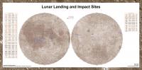
This is my latest version of the lunar landing/impact sites map, at reduced scale. A full size copy can be found here:
https://www.dropbox.com/s/wo60bbyfzoxhha2/m...te-map.jpg?dl=0 (it is about 30 MB) I made some changes. I added the Chang'e 5 T-1 upper stage impact on the far side. I added a current best guess as to the location of the Apollo 16 LM Ascent Stage impact. In the tables I removed the Apollo 10 and Apollo 11 LM stages which were previously thought to have crashed at unknown locations but are now thought to be still in orbit, according to Jim Meador's analysis, which I agree with. Phil
-------------------- ... because the Solar System ain't gonna map itself.
Also to be found posting similar content on https://mastodon.social/@PhilStooke Maps for download (free PDF: https://upload.wikimedia.org/wikipedia/comm...Cartography.pdf NOTE: everything created by me which I post on UMSF is considered to be in the public domain (NOT CC, public domain) |
|
 |
 
|
|
|
Apr 22 2022, 08:15 PM
Post
#467
|
|
|
Solar System Cartographer Group: Members Posts: 10229 Joined: 5-April 05 From: Canada Member No.: 227 |
Here is a link to an LRO page with the Apollo 16 EVA traverses (newly mapped from LRO images), a timeline and transcript. This is for the 50th anniversary.
Phil https://www.lroc.asu.edu/featured_sites/view_site/66 -------------------- ... because the Solar System ain't gonna map itself.
Also to be found posting similar content on https://mastodon.social/@PhilStooke Maps for download (free PDF: https://upload.wikimedia.org/wikipedia/comm...Cartography.pdf NOTE: everything created by me which I post on UMSF is considered to be in the public domain (NOT CC, public domain) |
|
|
|
|
May 3 2022, 08:26 AM
Post
#468
|
||
 Member Group: Members Posts: 349 Joined: 20-June 07 From: Slovenia Member No.: 2461 |
Apollo 16 traverse map, based on new tracks available from LROC site. |
|
|
|
|
|
|
May 19 2022, 07:54 PM
Post
#469
|
||
|
Member Group: Members Posts: 349 Joined: 20-June 07 From: Slovenia Member No.: 2461 |
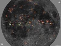
I was looking for Lunar Orbiter photographic footprints for some time as I wanted to add them to my Moon map.
To my surprise and given their importance in selecting Apollo sites for landings, I could not find the whole set as only partial selection is available from PDS. So I searched LO documentation and found tables in Lunar Orbiter Photography CR publications with corner coordinates for every photo taken. The downside was that all had to be typed manually, which took some time to complete. In addition the pdf for LO 3 misses half the pages, including the tables (if anyone has complete report please let me know), so I was forced to copy them directly from LOIRP data supporting files to complete the set. Anyway here are the results showing nearside coverage for missions 1,2,3 and 5, and separately one for LO 4. I plan to convert this data to GIS friendly archive so it can be used be anyone interested, but for now, if you need/want the source files, just drop me a note.
LO 1,2,3 and 5 near side coverage |
|
|
|
|
|
|
May 19 2022, 07:57 PM
Post
#470
|
||
|
Member Group: Members Posts: 349 Joined: 20-June 07 From: Slovenia Member No.: 2461 |
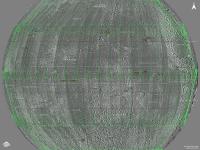
LO 4 coverage shown on original photos |
|
|
|
|
|
|
May 20 2022, 12:17 AM
Post
#471
|
|
|
Solar System Cartographer Group: Members Posts: 10229 Joined: 5-April 05 From: Canada Member No.: 227 |
I used to have his book:
https://www.lpi.usra.edu/resources/lunar_orbiter/photoGuide/ (now it's in our university library) It has maps showing footprints for each mission. Also I presume you have seen these resources: https://www.lpi.usra.edu/resources/lunarorbiter/#support Pretty good scans of all images (not as good as the LOIRP data, obviously) and supporting documents. Phil -------------------- ... because the Solar System ain't gonna map itself.
Also to be found posting similar content on https://mastodon.social/@PhilStooke Maps for download (free PDF: https://upload.wikimedia.org/wikipedia/comm...Cartography.pdf NOTE: everything created by me which I post on UMSF is considered to be in the public domain (NOT CC, public domain) |
|
|
|
|
Jun 24 2022, 02:56 AM
Post
#472
|
|
|
Senior Member Group: Members Posts: 2106 Joined: 13-February 10 From: Ontario Member No.: 5221 |
The crater(s!) from the impact have been found but still no positive ID on what it could have been!
http://lroc.sese.asu.edu/posts/1261 |
|
|
|
|
Jun 25 2022, 06:44 AM
Post
#473
|
|
|
Solar System Cartographer Group: Members Posts: 10229 Joined: 5-April 05 From: Canada Member No.: 227 |
No positive ID, but there seems to be wide agreement that it was the upper stage of the rocket which launched Chang'e 5-T1, the test flight of the re-entry capsule. China said no but they appear to have been talking about the Chang'e 5 upper stage.
Phil -------------------- ... because the Solar System ain't gonna map itself.
Also to be found posting similar content on https://mastodon.social/@PhilStooke Maps for download (free PDF: https://upload.wikimedia.org/wikipedia/comm...Cartography.pdf NOTE: everything created by me which I post on UMSF is considered to be in the public domain (NOT CC, public domain) |
|
|
|
|
Jul 5 2022, 07:29 AM
Post
#474
|
|
|
Solar System Cartographer Group: Members Posts: 10229 Joined: 5-April 05 From: Canada Member No.: 227 |
I have seen a lot of talk about the double crater nature of this impact. We don't know exactly what the situation was but the implication seems to be that there was a mass at each end of the empty tank. At one end the engines and associated plumbing provide the mass you would expect. At the other end, most likely there was a payload adapter to support the flight test model of the sample return capsule. That might be enough to account for what we see.
Phil -------------------- ... because the Solar System ain't gonna map itself.
Also to be found posting similar content on https://mastodon.social/@PhilStooke Maps for download (free PDF: https://upload.wikimedia.org/wikipedia/comm...Cartography.pdf NOTE: everything created by me which I post on UMSF is considered to be in the public domain (NOT CC, public domain) |
|
|
|
|
Feb 5 2023, 03:53 AM
Post
#475
|
|||
|
Solar System Cartographer Group: Members Posts: 10229 Joined: 5-April 05 From: Canada Member No.: 227 |
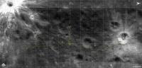
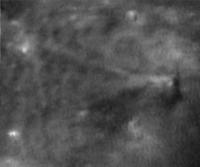
An earlier post (bottom of previous page) can now get an update. Jim Meador and I have been working on the problem of the Apollo 16 LM ascent stage. We have an LPSC abstract about it: https://www.hou.usra.edu/meetings/lpsc2023/pdf/1025.pdf I think we have found the impact site. It is extremely subtle but I think it is right. The abstract shows the location. This image shows 6 LRO-NAC images of the feature:
This is a merge of morning and afternoon illumination images, which suppress topographic shading and enhance albedo. The bright streaks and dark spots around the impact site are very similar to features seen at the Apollo 12 and 14 LM impact sites:
Phil -------------------- ... because the Solar System ain't gonna map itself.
Also to be found posting similar content on https://mastodon.social/@PhilStooke Maps for download (free PDF: https://upload.wikimedia.org/wikipedia/comm...Cartography.pdf NOTE: everything created by me which I post on UMSF is considered to be in the public domain (NOT CC, public domain) |
||
|
|
|
||
|
Mar 26 2024, 07:42 AM
Post
#476
|
||
|
Member Group: Members Posts: 349 Joined: 20-June 07 From: Slovenia Member No.: 2461 |
I was always tempted to try and convert Apollo Hasselblad Photography Index maps into vector form suitable to load into modern mapping software. As I could not find any numerical table (Apollo index only indicate image center coordinates) there was no other way but to load the maps and redraw all the data manually. This being time consuming process, I kept on postponing it indefinitely until recently. I started drawing Apollo 8 maps just to see if could be done, and on finding that the process produced adequate results, proceeded to the other missions. As for now the redrawing is almost complete, I only need to complete the footprints for the last mission, the Apollo 17. On the map stereographic photography footprints selection is plotted for all the missions except the Apollo 16, which took no Hasselblad stereo sequences. For Apollo 13 no index map exist, but I managed to find limited number of footprints from other sources. Color key for the map footprints is the following: A8 (light green, bordeaux red) A10 (green, light blue, violet) A11 (light yellow) A12 (blue and yellow) A13 (orange) A14 (red) A15 (ochre) A17 (cyan) I plan to post the data files as an archive once completed. You can always drop me a note if you would like to get the preliminary data. |
|
|
|
|
|
|

|
Lo-Fi Version | Time is now: 27th September 2024 - 10:38 AM |
|
RULES AND GUIDELINES Please read the Forum Rules and Guidelines before posting. IMAGE COPYRIGHT |
OPINIONS AND MODERATION Opinions expressed on UnmannedSpaceflight.com are those of the individual posters and do not necessarily reflect the opinions of UnmannedSpaceflight.com or The Planetary Society. The all-volunteer UnmannedSpaceflight.com moderation team is wholly independent of The Planetary Society. The Planetary Society has no influence over decisions made by the UnmannedSpaceflight.com moderators. |
SUPPORT THE FORUM Unmannedspaceflight.com is funded by the Planetary Society. Please consider supporting our work and many other projects by donating to the Society or becoming a member. |
|