Printable Version of Topic
Click here to view this topic in its original format
Unmanned Spaceflight.com _ Opportunity _ Opportunity Leaves Olympia
Posted by: Tesheiner Feb 24 2006, 09:06 AM
I think it deserves it's own thread!
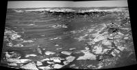
Sol 741 post-drive pancam "stamps" are finally made available at the tracking web. Here is the 4x1 mosaic and a similar one taken on sol 733.
|
Maybe I'm jumping too fast, but I believe Oppy left Olympia on sol 741 and is on the road again!
PS: I hope haz and navcams are promptly available at the MER webpage to confirm it.
Posted by: Analyst Feb 24 2006, 09:29 AM
Finally!
Posted by: Toma B Feb 24 2006, 09:30 AM
It was about time! 
Posted by: SFJCody Feb 24 2006, 11:13 AM
http://origin.mars5.jpl.nasa.gov/gallery/all/opportunity.html 
Posted by: Tesheiner Feb 24 2006, 11:20 AM
Confirmed!
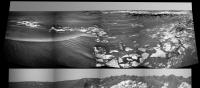
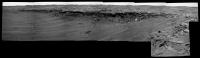
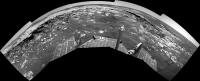
Here is a quick navcam panorama looking forward. Clear route to Mogollon AND tosol (742) is planned as another driving sol.
|
Let me light some fireworks. It's celebration time!


Posted by: climber Feb 24 2006, 11:23 AM

Sol 741 post-drive pancam "stamps" are finally made available at the tracking web. Here is the 4x1 mosaic and a similar one taken on sol 733.
|
|
Maybe I'm jumping too fast, but I believe Oppy left Olympia on sol 741 and is on the road again!
PS: I hope haz and navcams are promptly available at the MER webpage to confirm it.
Yes Yes Yes Yes [color=#FF0000]! But they can't believe it themselves since they had to put the IDD in the long forgotten fiture made by the weels as Oppy turn !!!
 http://marsrovers.jpl.nasa.gov/gallery/all/1/f/741/1F193969405EFF64TIP1214L0M1.HTML
Posted by: jamescanvin Feb 24 2006, 12:03 PM
Here is a quick navcam panorama looking forward. Clear route to Mogollon AND tosol (742) is planned as another driving sol.
|
|
Let me light some fireworks. It's celebration time!
Nice!
So great to see some images that don't look TOO familiar!
Looking forward to lots of driving
Lets get a LONG way away from Olympia ASAP!
James
Posted by: Bill Harris Feb 24 2006, 12:24 PM
Wonderful. We are now on the road again. I was a bit shocked when they whipped out the IDD, but this may be an encouraging sign that they are confident to use it after a short drive.
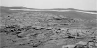
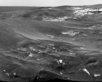
There are L456 Pancam of the outcrop at her wheels online. I don't have time now to make a color image, so feel free to do so! Interestingly, the bedrock here seems to be very fractured and jumbled.
Unless she fiddles around at this spot, we are within 1 Sol of Nirvana. More later today, no doubt.
--Bill
Posted by: Tesheiner Feb 24 2006, 12:48 PM
IIRC, unstowing the IDD after any drive is part of the "new strategy". If the shoulder motor gives up permanently, they want that to happen with the IDD deployed.
Drawbacks? Imo, we will see more unsuccessful drives in the future due to stowage failures.
Another point. I calculated the distance to the "suspect" outcrop where the rover is now located (the left one on previous route proposals) and the net drive was about 40m.
Edited: And based on the current navcams, the distance to the black outcrop is about 20m. Too close? Based on the route maps there should be about 50m until Mogollon.
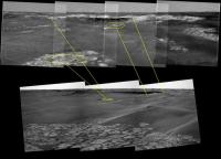
Posted by: Phil Stooke Feb 24 2006, 01:57 PM
This is the half-pan we have so far for Sol 741 in polar projection. Thanks for the original, Tesheiner.
Phil
|
and this is where I think we are now...
|
Posted by: MahFL Feb 24 2006, 02:04 PM
It's nice to see a new perspective

Posted by: Bill Harris Feb 24 2006, 02:09 PM
And thank you for the demi-polar.
Notice how the sand is moving in the trough south of Oppy. I don't recall seeing it "flow" like that before. I see other possibly interesting features here too, but let me look at the images before flapping my gums...
--Bill
EDIT: nevermind, I _was_ flapping my gums. I mentally inverted the dune crest and it wasn't a trough. Nothing unusual.
Another correction: all these months I've thought that the dark sand area to the left (east) of the views of Mogollon was the Payson promontory? Nope, Payson is a bit further down and much larger. Ths dark sand area is just an aeolian feature.
Posted by: djellison Feb 24 2006, 02:35 PM
That's the figure JB suggested at the last QnA
Posted by: Nirgal Feb 24 2006, 04:14 PM
http://mitglied.lycos.de/user73289/misc/oppy_f741_col_a.jpg
it's been views like this I've been missing so badly 
Posted by: mhoward Feb 24 2006, 04:29 PM
Thank goodness. What a relief.
The remaining Pancam images should be nice once they've come down (covering Mogollon, presumably). I wonder if we'll drive again right away.
Posted by: dilo Feb 24 2006, 06:14 PM
Finally!
Posted by: Olenthra Feb 24 2006, 06:23 PM
It's been soo long. I wonder if anybody can repost the last amazing Route Map by dilo in the Opportunity Route map thread.
Time to explore again!
Posted by: Zeke4ther Feb 24 2006, 06:30 PM
it's been views like this I've been missing so badly
Nice!...
On to new adventures.
Posted by: helvick Feb 24 2006, 06:32 PM
it's been views like this I've been missing so badly
Another Meridiani Masterpiece
Very nice Nirgal.
Posted by: Nix Feb 24 2006, 06:36 PM
So glad our Meridiani-girl is... On the road again! It's priceless Nirgal, one of your best
Nico
Posted by: Sunspot Feb 24 2006, 06:36 PM
Opportunity's hazard cams are very dirty......
Posted by: Burmese Feb 24 2006, 06:48 PM
Are they still playing songs each day for the rovers? Did they cue up some Willie Nelson for Oppy in the last day perhaps?
Posted by: DrZZ Feb 24 2006, 07:12 PM
At the MRO news conference they mentioned that they hoped to get detailed enough pictures of the Victoria region to be a big help to the MER team in route planning. I assume that means they are going to do some useful things during the aerobraking phase. The alternative (waiting until sometime in the fall when MRO gets into "science orbit") might be too much for some around here to bear.
Posted by: mhoward Feb 24 2006, 08:42 PM
I've never really figured out the Pancam Tracking web interface, but it looks to me like Sol 742 is another driving day. If Exploratorium were working, we'd probably be looking at the images already.
Posted by: Tesheiner Feb 24 2006, 09:21 PM
Indeed a driving day Michael, and a successful one.
The data on the tracking web tells again a significant change of "drive id": 64TI -> 640D. Let's wait for the images; I have the impression that the view will be magnificent.
Posted by: mhoward Feb 24 2006, 09:26 PM
The data on the tracking web tells again a significant change of "drive id": 64TI -> 640D. Let's wait for the images; I have the impression that the view will be magnificent.
Excellent! I tried to access the thumbnails, but I don't think they're up yet. Man, I miss Exploratorium.
Posted by: Tesheiner Feb 24 2006, 09:35 PM
The Exploratorium is up and running again!
http://qt.exploratorium.edu/mars/opportunity/navcam/2006-02-24/
Posted by: Marslauncher Feb 24 2006, 09:37 PM
wow beat me to it by 1 min!!
Posted by: SFJCody Feb 24 2006, 09:38 PM
http://qt.exploratorium.edu/mars/opportunity/navcam/2006-02-24/1N194058947EFF640DP0700L0M1.JPG
Posted by: mhoward Feb 24 2006, 09:43 PM
Holy... cow.
Posted by: Tesheiner Feb 24 2006, 09:47 PM
Beautiful!
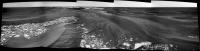
And here the two images stitched together.
|

PS: Today I had my mars fix. No doubt!
Posted by: Bob Shaw Feb 24 2006, 10:21 PM
The only problem is that, having moved six inches to the right, we've now got something else that demands a month of study! Ah, the curse of riches...
Bob Shaw
Posted by: climber Feb 24 2006, 10:31 PM
And here the two images stitched together.
|
|
PS: Today I had my mars fix. No doubt!
Too long drive. We ended up at the South side of Home Plate ! Is that Mogollon ?
Posted by: djellison Feb 24 2006, 10:37 PM
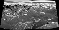
4 frames with a streth-a-thon of the horizon.
Doug
|
Posted by: Nirgal Feb 24 2006, 11:04 PM
this is sooo cool
I simply can't describe this feeling of sitting here in front of a computer screen and at the same time
virtually roving in near real time the bizarre landscapes of an entirely alien world, 100 millions miles away,
watching, through the roving machine's eyes, images of sceneries no one has ever seen before ...
thank you, JPL for the Rovers !
thank you, world, for the internet !
phantastic, absolutely phantastic
Posted by: Bill Harris Feb 25 2006, 12:13 AM
> Holy... cow.
...is right. It looks a as important as Homeplate and she doesn't have to be home by 11:00.
Attached is a crop from Tesheiner's recent Navcam pan of Sol 741 showing what I think the path was and might be tomorrow-Sol. "A" is where the end of drive Navcams and Pancans were taken; the path might continue straight ("B") or might go to the right ("C"). "B" is 1N194058757EFF640DP0700L0M1.jpg
and "C" is 1N194058947EFF640DP0700L0M1.jpg .
Let me get back to the images before I pass out....
--Bill
Posted by: Sunspot Feb 25 2006, 12:41 AM
Are we seeing similar structures to those seen in Burns Cliff?
Posted by: Bill Harris Feb 25 2006, 01:45 AM
We don't know, yet. It is layered, but it looks more like the Rimrock outcrop where we did penance at recently. Has it ever been determined why "rimrock", et al, erode like it does and not like the "usual" flat paving stones?
Looking forward to tomorrow's views.
--Bill
Posted by: RNeuhaus Feb 25 2006, 02:00 AM
And here the two images stitched together.
|
|
PS: Today I had my mars fix. No doubt!
That is great to feel that Oppy is back driving!
Wow, it looks even more interesting than I tought!
These Mogollon rim would be an alike to HP's strata
Rodolfo
Posted by: RNeuhaus Feb 25 2006, 02:33 AM
Not yet by sure. Need to approach closer to see the strata.
Rodolfo
Posted by: dvandorn Feb 25 2006, 03:22 AM
Well... let me be something like the 20th person here to say, "Finally!"
And the third or fourth person here to say, "Wait a second -- that's not Mogollon, that's Home Plate!"
-the other Doug
Posted by: Shaka Feb 25 2006, 03:24 AM
Wow, it looks even more interesting than I tought!
These Mogollon rim would be an alike to HP's strata
Rodolfo
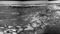
Na, richtig toll, Mensch, gel? I really wondered if I'd live to see the day.
From this distance there seems to be at least one area with a good basal exposure (yellow circle).
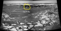
|
or else along the 'ramp' on the right. Man, it looks like a piece of cake to get around here. I was expecting a sandy morass.
Work it, boys! Science calls!
Posted by: dvandorn Feb 25 2006, 03:45 AM
This image, of the rim of Erebus, showing where the uppermost layers collapsed a la the collapses around the rim of Endurance, but with an almost-level paving of evaporite rock below the rover's wheels, just reinforces my impression that Erebus must have been inundated by standing water *after* it was formed. Perhaps a multitude of times.
Can anyone here say they don't see how it's impossible that the entire crater wasn't inundated by water after it formed? How else can it be *filled* with evaporite?
-the other Doug
Posted by: neb Feb 25 2006, 03:46 AM
From this distance there seems to be at least one area with a good basal exposure (yellow circle).
|
|
or else along the 'ramp' on the right. Man, it looks like a piece of cake to get around here. I was expecting a sandy morass.
Work it, boys! Science calls!The material beneath the planar rimrock appears from this distance to be massive with little bedding .
There are some near vertical fractures and it will be interesting if they project up to the openings we have seen in the planar slabs. The structure appears to be a small half saucer. I don't believe it is erosional and an impact would be more circular. Bill, what could have caused the subsidence that terminates in either direction?
Posted by: dilo Feb 25 2006, 07:40 AM
..perhaps this sharpened view could help.

|
Distance from the "piece of cake" highlighted by Shaka is 13m, outcrop height above the lower plain is close to 80cm in this point...
Posted by: abalone Feb 25 2006, 07:46 AM
Thats another Wow!!

|
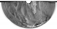
Posted by: dilo Feb 25 2006, 09:00 AM
Full 360 deg panorma from right cam (70% scale)
|
|
Posted by: Bill Harris Feb 25 2006, 09:55 AM
This is going to be a fascinating area to study. The underlying unit is somewhat massive but still laminated with a darker and redder tone than the overlying pavement unit. My impression is it represents the paleo- surface that Erebus impacted and later erosion and deposition occurred over it. We need to get many Pancam views of the sedimentary structure and get an idea of the minerology.
I'm wondering what keeps it open-- on this nice flat plain the tendency would be for sand deposition, these low areas would tend to decrease wind velocity and drop sand.
--Bill
Posted by: Tman Feb 25 2006, 10:24 AM
-the other Doug
No, but I'm still bemused how flat Erebus appears. I even think that the impact took place directly in standing water like a "shallow" lake and so the crater "drowned" by the floating back mud immediately - or after the impact the area experienced a flood (of what?) that was big enough to fill the crater. The same for Vostok.
Posted by: djellison Feb 25 2006, 11:35 AM
Wont post my stitch of the full 360, it's cack compared to dilos - but here's my polar of it.
Doug
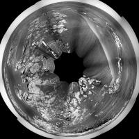
|
Posted by: jvandriel Feb 25 2006, 01:44 PM
Here is the pancam L2 view.
Taken on Sol 742.
jvandriel

|
Posted by: sranderson Feb 25 2006, 04:56 PM
It appears that the top layer on the cliff is the same as the evaporite layer below the cliff (that we are sitting on). There are probably a number of explanations for this, but I can think of two: 1) Subsidence, or 2) deposition after the cliff formed. In the second case, the evaporite would preferentially form on flat surfaces; any that formed on the cliff face would erode off, particularly as erosion forced the cliff to recede.
I think the cliff fairly clearly defines the Erebus crater rim, and that the evaporite clearly formed after the Erebus impact. This would argue for the scenario where the deposition occurred after the cliff formed -- and is missing from the cliff face due to erosion.
Thoughts?
Scott.
Posted by: Phil Stooke Feb 25 2006, 05:02 PM
Here is my version of a polar pan (not pure polar, but with a progressively compressed foreground to better approximate map geometry)... where was I? - oh yeah - pan from Sol 742. It's from dilo's pan - which has only 9 of the 10 pics in it.

|
I can't claim to be as excited as Bill about this location. It looks a lot blander than Burns Cliff or Home Plate to me. An outcrop with nearly a metre of visible section is good, but will it really give us much new? Maybe the remote sensing will show something interesting. I wouldn't expect to be here very long.
As for the shallowness of Erebus, another topic from above... I don't really see this as an impact into water or a crater once filled with water. I'd go for an ordinary crater in dry rock, but heavily eroded since then. It seems clear to me that the evaporite stuff we are seeing throughout this area erodes quite quickly in Martian terms - lack of blocky ejecta around all but the freshest craters, for instance, not to mention the large quantity of blueberry-containing material eroded away to create such a large lag deposit of blueberries. So I think Erebus and Terra Nova, and similar features throughout this area, are just the eroded roots of old, once-proud craters, a bit like Manicouagan in Quebec.
Phil
Posted by: Bill Harris Feb 25 2006, 05:11 PM
It really isn't all that exciting, but is it remarkably different than anything we've seen before. It is blander than Burns Cliff, but given the eroded state of Erebus, it is remarkable.
It's a geologist thing. Humor us.
Nice Polar.
--Bill
Posted by: neb Feb 25 2006, 06:55 PM
I think the cliff fairly clearly defines the Erebus crater rim, and that the evaporite clearly formed after the Erebus impact. This would argue for the scenario where the deposition occurred after the cliff formed -- and is missing from the cliff face due to erosion.
Thoughts?
Scott.
Scott: I agree that the two layers you mention are the same but I tend to lean toward subsidence along an old crater rim with the following sequence of events.
First - Deposition of some layered beds
second- Impact crater formed with small rim
third- Erosion and filling of crater to near plane
fourth- Deposition of layered Meridiani beds culminating in evaporite sequence
fifth- Minor erosion and dune formation
sixth- Differential subsidence along old crater rim which offsets evaporite layer
Posted by: jvandriel Feb 25 2006, 07:05 PM
Phil,
here is the complete one.
A 360 degree panoramic view on Sol 742.
Taken with the L0 navcam.
jvandriel
|
|
Posted by: mhoward Feb 25 2006, 07:20 PM
Here are a couple MMB views using a de-vignetting technique I'm playing with.
http://www.flickr.com/photo_zoom.gne?id=104269255&size=o http://www.flickr.com/photo_zoom.gne?id=104268944&size=o
Posted by: mars loon Feb 25 2006, 07:26 PM
Endlich etwas neues !!
Finally something new !!
WOW. "Holy Toledo" and perhaps a few more .....
And a real drive too not just a few cm.
Boy, I had to sadly do "real" work instead of "martian" work for a few days and missed this till I read the latest JPL update this morning and wandered over here.
ken
Posted by: lyford Feb 25 2006, 07:37 PM
Yes, please! They look fantastic.... can we start getting our hopes up for the next release?
Posted by: Zeke4ther Feb 25 2006, 07:42 PM
lyford, Michael has just put out a new release (1.4.4)
Check it out on his web site
Posted by: Burmese Feb 25 2006, 07:49 PM
http://marsrovers.jpl.nasa.gov/mission/status.html#opportunity
"Sol 741: Opportunity drove 34.5 meters (113 feet) closer to the Payson outcrop after rover drivers set the current limits back to nominal values. Motor currents at the start of the drive were a bit higher than normal but dropped closer to normal values as the drive progressed."
Looks like not moving for a long time allowed the lubricants to settle noticably. Keep that puppy moving!
Posted by: mhoward Feb 25 2006, 08:09 PM
Check it out on his web site
1.4.5 (the next one) will probably have the de-vignetting feature... but it may take me a while to finish it yet. I've got to experiment with it more, and I don't have any time to work on it... yadda yadda yadda. Glad you like it though, lyford.
Posted by: Shaka Feb 25 2006, 09:08 PM
Phil
I'm inclined to agree with you. I don't think there is a general appreciation of the destructiveness of a hypervelocity impact. Very little in the immediate vicinity of the impact point retains its original fabric or orientation. Although Erebus is a very small crater compared to the ones forming the basis of current cratering models, one couldn't really expect to see intact much of the surface layering present at the time of impact, right on the crater rim. That would be shattered and disrupted into impact breccia.
Posted by: Bob Shaw Feb 25 2006, 09:19 PM
Er... ...no, it's not that simple!
My understanding is that, generally, the pre-existing layers are deformed and may be turned back over themselves, and that the blocky debris closest to the crater rim is generally from deepest within the pre-existing structures. I'm sure that somebody else will have a more cogent technical description of the process, but suffice it to say that it's *not* just an almighty wallop - there's a formal structure to impact events of any decent scale. And then the erosion starts...
Bob Shaw
Posted by: Sunspot Feb 25 2006, 09:43 PM
Oh don't say the exploartorium is offline again already... images are down but nothing showing up on the site.
Posted by: lyford Feb 25 2006, 10:14 PM

zeke - I have it now- thanks - though I am running out of HD space - time to delete all those BeeGees MP3s
Posted by: dilo Feb 25 2006, 10:25 PM
Happy to ear this, Michael!
Posted by: mhoward Feb 25 2006, 10:30 PM
Happy to ear this, Michael!
Well, I wouldn't get too excited about it yet. MichaelT's anti-vignetting tool will probably remain a better choice when creating non-MMB panos. I just got tired of the ugly joins in MMB views, and am trying to see if I can do anything about it without too much effort.
Posted by: dvandorn Feb 26 2006, 12:55 AM
First - Deposition of some layered beds
second- Impact crater formed with small rim
third- Erosion and filling of crater to near plane
fourth- Deposition of layered Meridiani beds culminating in evaporite sequence
fifth- Minor erosion and dune formation
sixth- Differential subsidence along old crater rim which offsets evaporite layer
I don't entirely agree. First off, Erebus is several times larger than Endurance. It would not have had a small rim when it formed. It would have had a very pronounced rim, a bowl shape, and a deep floor. As time went on, it would have suffered collapse along the outer rim, as the very steep faces of the inner walls of the crater are not stable over long periods. You get a characteristic scalloped rim as a result of the edges of the rim falling into the crater, widening and shallowing it.
According to my understanding of lunar crater development and aging, it takes the better part of a billion years for a crater the size of Erebus to become as wide and as shallow as mass wasting is going to make it.
Note, too, how Endurance has been partially filled with dust, but is nowhere near "filled" to the extent that Erebus is. And Endurance may well be more than a billion years old.
The problem with Erebus spending eons being worn down to a nub of a crater *before* the evaporites were layed down over it is that, according to curren theory, Mars was only wet enough for the large mass of evaporites we observe to have been laid down for a fairly short period of Mars' early history. My best guess is that there was simply not enough time for an Erebus-sized crater to have been worn down to nearly planar before Mars froze up and standing water was no longer possible.
I would amend your timeline as follows:
First - Deposition of some layered beds (mostly from dune formations)
Second - A shallow sea forms cyclically in the area, laying down layer after layer of evaporite
Third - A cluster of impact craters (including Erebus and Terra Nova) form after some of the local evaporite is laid down
Fourth - Deposition of the rest of the layered Meridiani beds and subsequent groundwater alteration, filling the Erebus-Terra Nova complex with evaporite shot full of hematitic concretions
Fifth - General raising of the land by volcanic uplift of Meridiani Terra south and east of Meridiani Planum, putting an end to standing water by changing the landform and raising it above the then-current "sea level" where seas were able to form
Sixth - Erosion of evaporite, formation of hematite-enriched soils, and dune formation
Seventh - Differential subsidence along old crater rim which offsets evaporite layer along old rim
I just don't think there was time for Erebus and the cluster it's associated with to form and degrade to a filled-in status and *then* have a Mars warm and wet enough to cover that over with evaporite. I think there had to have been evaporite formation both before and after the creation of Erebus.
-the other Doug
Posted by: Shaka Feb 26 2006, 01:01 AM
First - Deposition of some layered beds
second- Impact crater formed with small rim
third- Erosion and filling of crater to near plane
fourth- Deposition of layered Meridiani beds culminating in evaporite sequence
fifth- Minor erosion and dune formation
sixth- Differential subsidence along old crater rim which offsets evaporite layer
I like your scenario, neb. Closer examination of what lies before us (Coming soon to a JPL website near YOU!!)
) might suggest alternatives, but even by Martian standards Erebus is a genuine antique. There seems to be little of the original structure accessible for us to look at.
Posted by: Shaka Feb 26 2006, 01:25 AM
My understanding is that, generally, the pre-existing layers are deformed and may be turned back over themselves, and that the blocky debris closest to the crater rim is generally from deepest within the pre-existing structures. I'm sure that somebody else will have a more cogent technical description of the process, but suffice it to say that it's *not* just an almighty wallop - there's a formal structure to impact events of any decent scale. And then the erosion starts...
Bob Shaw
I'm aghast, Bob, if anyone got the impression from my 'thumbnail summary' that impact crater formation is "simple". I would hardly call it that, although there has been enough progress made over the last 20 years with Hydrocode models of cratering on size scales that are of geological interest, to permit some reasonable quantification of the parameters, given reasonably representative impactors and target lithologies. For anyone seeking a good basic understanding of the process, I can recommend reading Jay Melosh's textbook: Impact Cratering: A Geologic Process from Oxford Monographs, 1989. Though obviously 15 years out of date, and probably out of print, it should be found in most decent university libraries, and is a good starting reference. The math, of course, is a bit daunting, but even an informed layperson will be able to read around that and get the gist.
Since then there has been continuing progress in the models, so a thorough updating will require some reading in the primary and secondary literature. Topics such as acoustic fluidization, shatter cone formation, and improved equations of state governing vaporization, are much better defined now, and make such a foray rewarding. I'm happy to provide a selected reference list by email to anyone who wants it.
Posted by: Zeke4ther Feb 26 2006, 03:42 AM
First - Deposition of some layered beds (mostly from dune formations)
Second - A shallow sea forms cyclically in the area, laying down layer after layer of evaporite
Third - A cluster of impact craters (including Erebus and Terra Nova) form after some of the local evaporite is laid down
Fourth - Deposition of the rest of the layered Meridiani beds and subsequent groundwater alteration, filling the Erebus-Terra Nova complex with evaporite shot full of hematitic concretions
Fifth - General raising of the land by volcanic uplift of Meridiani Terra south and east of Meridiani Planum, putting an end to standing water by changing the landform and raising it above the then-current "sea level" where seas were able to form
Sixth - Erosion of evaporite, formation of hematite-enriched soils, and dune formation
Seventh - Differential subsidence along old crater rim which offsets evaporite layer along old rim
I just don't think there was time for Erebus and the cluster it's associated with to form and degrade to a filled-in status and *then* have a Mars warm and wet enough to cover that over with evaporite. I think there had to have been evaporite formation both before and after the creation of Erebus.
-the other Doug
Doug, I have to agree with you, I like your time-line better. I think it fits more in line with how long water was available on Mars.
The lack of any large blocks that would have formed from the impact events that Bob mentions would have been eroded away during time point 'six' in your time-line above.
Posted by: CosmicRocker Feb 26 2006, 06:47 AM
I think the cliff fairly clearly defines the Erebus crater rim, and that the evaporite clearly formed after the Erebus impact. This would argue for the scenario where the deposition occurred after the cliff formed -- and is missing from the cliff face due to erosion.
Thoughts?
Scott.
I hate to come in as a contrarian, especially considering how difficult it seems to remotely interpret these busted-up rocks. But I am not convinced that the top layer is draping. Looking at the pavement above the escarpment and going off to the left of Opportunity, I see bedding planes coming to the surface and striking off, across the top surface of the outcrop. If I follow some of them back to the vertical section, they seem to dip off to the left. It's a tough call, since the rock is so broken up. I wouldn't bet more than a six-pack or it's equivalent until we get closer.
The dipping beds I think I see also have implications for the dark strata we have been waiting so long to see up close. If those dark beds are actually coming to the surface as such dips would suggest, they do not appear as dark stripes on the surface. I'm thinking the dark stuff is only evaporite-cemented sandstone that has collected some dust or other stain.
I made a crude animated gif to illustrate what I think I am seeing. It alternates between a view of the outcrop, and one displaying a few possible dip lines leading to strike lines on the surface.

|
Posted by: Sunspot Feb 26 2006, 12:05 PM
Sol 743:
http://origin.mars5.jpl.nasa.gov/gallery/all/opportunity_p743.html
Posted by: SigurRosFan Feb 26 2006, 12:15 PM
Welcome to Homeplate 2.
Posted by: abalone Feb 26 2006, 12:45 PM
The dipping beds I think I see also have implications for the dark strata we have been waiting so long to see up close. If those dark beds are actually coming to the surface as such dips would suggest, they do not appear as dark stripes on the surface. I'm thinking the dark stuff is only evaporite-cemented sandstone that has collected some dust or other stain.
The layers look fairly horizontal to me, that is allowing for some disturbance and disruption

|
Posted by: Bill Harris Feb 26 2006, 01:30 PM
>I hate to come in as a contrarian, especially considering how difficult it seems to remotely interpret these busted-up rocks
No kidding!
I'm still looking at this in awe, going "hmmmm".
More later; I've gotten behind in viewing, I installed a new firewall that did a good job protecting me from Internet hazards by keeping me OFF. 
Tom, what is your source image used in your animation? I'm thinking dilo's "pano 742 sharp". In addition to your dipping beds, look also at the several vertical fractures or joints. This area does look like a depression or sinkhole; think Anatolia???
This is looking more and more like Burns Cliff II. Attached is a section at Endurance for a refresher.
More later...
--Bill
Posted by: CosmicRocker Feb 26 2006, 02:38 PM
Bill: My image is a crop of an Autostitched panorama from the sol 742 navcams that I made. It looks as if some new imagery is in. I need to download it to see if we have any better views.
Posted by: Bob Shaw Feb 26 2006, 03:18 PM
Bill:
'Anatolia' was indeed the word I was toying with in my head when I saw the images - I also wonder how many unseen rover-traps we've skirted over!
Bob Shaw
Posted by: Bill Harris Feb 26 2006, 04:12 PM
Tom, then that is a good job of auto-stitching. I've developed somewhat of a lazy streak with all the fine imagery around here. If I see something I want to illustrate or annotate in an image I see here I tend to modify that image, keeping the same filename root and give credit. Technically that is "infringement" but that is fair use in a discussion and I never take an image to another site.
Bob, yep, when I see paving stones with sand funnelling around their edges, I've wondered where the sand goes. We don't have solid evidence that this is a karst-like situation, but that hasn't been ruled out.
This reminds me of a predicament I got myself into at work many years ago: I foolishly walked out onto a burning coal stockpile and 40' onto the pile a nearby square-meter section of the surface collapsed into a Burning Pit Of Hell. I carefully retraced my steps back out.... The folly of youth.
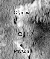
Attached find two stretched color images taken last year from the North Erebus rim and from Olympia. The first image shows the current outcrop on the right and the other "Payson" area on the left separated by that dark sand dune; the second image shows the outcrop we are currently looking at. This should give us an idea of colors until we get something current at this site.
There is going to be some excellent structure and petrology here.
--Bill
Posted by: RNeuhaus Feb 26 2006, 06:02 PM
From this distance there seems to be at least one area with a good basal exposure (yellow circle).
|
|
or else along the 'ramp' on the right. Man, it looks like a piece of cake to get around here. I was expecting a sandy morass.
Work it, boys! Science calls!Ja sehr ist der geehrte Herr, steuernd auf Mars immer faszinierend!
Keep watching on Mars. Have a fun time with the good picture and coments sharing of USMF's members!
Erebus's case is an unique . There is still not good hypothesis to prove about how it was formed. The Erebus was created when there was water, the reason is that the rims are low and rounded and not so deep since the water acts an moderator force to lease the impact force. The other hypothesis is that the Erebus is very much older than Endurance crater and it is very eroded by water and winds which have played the rol of higher rounded and degrated of Erebus' rim.)
Let us see about what is the best hypothesis about this but I feel that it won't be the final true since we are not a witness of this event. Hope, we will have a machine time to confirm this, and it is in utopia.
Rodolfo
Posted by: climber Feb 26 2006, 06:22 PM
I said it firts, I said it first
(I like so much to be right visualy and ...wrong technicaly...)
Posted by: djellison Feb 26 2006, 06:36 PM
Welcome to Burns Cliff 2 surely? It looks JUST like the top metre of Burns Cliff ( hardly unexpected )
Doug
Posted by: Bob Shaw Feb 26 2006, 08:43 PM
)Doug
Doug:
But here, it's up close and personal!
After all the complaints about sitting around for so long on one spot, it irks me to have to say that I hope we *don't* leave here in the near future!
Bob Shaw
Posted by: dilo Feb 26 2006, 09:34 PM
Parallax calculator output:
distance from features at the center of image: 8.36m (+/- 3cm)
height of the escarpment: about 50cm (scale is 2.35mm/pixel)
Posted by: RNeuhaus Feb 26 2006, 10:00 PM
http://qt.exploratorium.edu/mars/opportunity/navcam/2006-02-24/
I had just visited at qt.exploratorium.edu and it has stopped again the captation of pictures from Opportunity. Its last image update was February 24. Its does not happens uniquely to Opportunity but also to Spirit. So, now, the only updated source from MER is only of the Mars Rovers JPL web site. Isn't it?
Rodolfo
Posted by: climber Feb 26 2006, 10:10 PM
)Doug
I don't remember pieces of Burn Cliff falling around like what we can see here. In this aspect (at least?) it looks like HP. It's sure a smaller fiture and much more steeper.
What is even more puzzling is the fine strata that we can see on the top...this also look like much more like HP than Burn Cliffs to me. Fist time we see this in Meridianii ? I think yes.
Posted by: dilo Feb 26 2006, 10:16 PM
distance from features at the center of image: 8.36m (+/- 3cm)
height of the escarpment: about 50cm (scale is 2.35mm/pixel)
I was referring to features at the centrer of http://origin.mars5.jpl.nasa.gov/gallery/all/opportunity_p743.html PanCam views..

|
While waiting for true color sequences, I made this pseudo color view... it is a kind of divertissment, I cannot reach the level of great Nirgal works but I made many other improvements/changes over the original R1 version (do you guess which ones?)...
Posted by: Bob Shaw Feb 26 2006, 10:22 PM
|
|
While waiting for true color sequences, I made this pseudo color view... it is a kind of divertissment, I cannot reach the level of great Nirgal works but I made many other improvements/changes over the original R1 version (do you guess which ones?)...
Marco:
Move over HP - I got a new desktop!
Great image!
Bob Shaw
Posted by: Bill Harris Feb 26 2006, 10:34 PM
Woha! That is one great colorized view! I'm going to wait, though: my favorite desktop wallpaper is still Spirit at the Peak.
What puzzles me is how this bluff is eroding. It lays on the downwind side of the scarp: prevailing wind is from the NW.
--Bill
Posted by: Myran Feb 26 2006, 11:12 PM
Windpatterns might change over the milennia, yet we dont even have to assume that, simple temperature cycles might cause quite some eroding over the extensive timespans we're dealing with here.
Posted by: Nirgal Feb 26 2006, 11:42 PM
|
|
While waiting for true color sequences, I made this pseudo color view... it is a kind of divertissment, I cannot reach the level of great Nirgal works but I made many other improvements/changes over the original R1 version (do you guess which ones?)...
beautiful colorization, dilo ! ...
love this view with the ragged cliffs in front of sand dunes
I was about making a colored version of this too, but you beat me to it
Can't probably do much better than this anyway
... sure they will also do a full filter pan of this one
Posted by: Shaka Feb 26 2006, 11:44 PM
Rodolfo
 Good question. There may be websites you and I don't know about. What do the 'code' pages say about today's activities. Is Oppy rolling up to the section? Is Spirit crossing the Plate?
Maybe the techs at Exploratorium are so exhausted from last week's struggle to fix things that they fell asleep under their desks.
They've probably earned a day's rest. I hope they realize how much we appreciate their day-to-day efforts, despite our recent whingeing about the stoppage. Does anyone's grapevine indicate what the problem was? Hardware? Communications? Ho hum, tomorrow's another day.P.S. Herzlichen Gluckwunschen zum Erfolg eures Olympiamannschafts in Turin!
Posted by: mhoward Feb 27 2006, 01:19 AM
Some more views from near Payson:
http://flickr.com/photo_zoom.gne?id=104968202&size=l http://flickr.com/photo_zoom.gne?id=104970294&size=l http://flickr.com/photo_zoom.gne?id=104968512&size=l
http://flickr.com/photo_zoom.gne?id=104969364&size=l
Posted by: Bill Harris Feb 27 2006, 02:56 AM
And, embarrassingly, here I am accustomed to thinking in terms of geological timespans. It's still hard to think of an outcrop sitting on the surface and eroding for many, many millions of years.
Posted by: CosmicRocker Feb 27 2006, 05:37 AM
I am "allowing for some disturbance and disruption" as best I can. Anyway, I've got to stick with the interpretation from the 742 navcams until better imagery settles it one way or another. ...and now we're back in http://www.google.com/search?q=define%3Alimbo again.

Posted by: Tesheiner Feb 27 2006, 10:00 AM
Today (sol 745) is planned as driving sol.
They've probably earned a day's rest. I hope they realize how much we appreciate their day-to-day efforts, despite our recent whingeing about the stoppage. Does anyone's grapevine indicate what the problem was? Hardware? Communications? Ho hum, tomorrow's another day.I sent an email to the exploratorium webmaster (ronh@ exploratorium.edu) on the 24th telling about the situation and asking for news. No answer to the email but, coincidence or not, the webpage was updated that day.
Who wants to try this time?
Posted by: djellison Feb 27 2006, 11:53 AM
I'm hopefull that the colour will come thru a bit later.
Doug
|
Posted by: Bob Shaw Feb 27 2006, 12:06 PM
Doug
More outcrops in the distance? Or is that crater rim?
Bob Shaw

|
Posted by: Bill Harris Feb 27 2006, 12:15 PM
Doug, there is an L2,3,4,5,6,7 and Rx,x,x sequence at the JPL site for Sol-743.
Bob, those outcrops are the area around Payson, look at my route map from 25.02.06...
--Bill
Posted by: djellison Feb 27 2006, 12:16 PM
Going on the orbital imagery - and the pointing - I'd say it's little bits of southern erebus, but there's lots of bits and pieces like it all around.
Doug

|
Posted by: Bob Shaw Feb 27 2006, 12:21 PM
Bill and Doug:
Are you both talking about the same things, but with different names, or not? If you see what I mean.
Some nicely aligned outcrops would be a Good Thing, I think...
Bob Shaw
Posted by: djellison Feb 27 2006, 12:25 PM
There's a full filter sequence for one frame, but there was an L257 for all the frames in that little mosaic just about, that's the data I'm refering to. it's down at the tracking site in thumbnail form, nothing more yet.
Doug
Posted by: Phil Stooke Feb 27 2006, 01:56 PM
Do we know which feature was called 'Zane Grey'?
Phil
Posted by: Bill Harris Feb 27 2006, 01:56 PM
The full L23567 sequence is for one frame so far, but that will give us geo-geeks a good start on figuring out the lithologies here.
Bob, it _is_ confusing. The horrid 25 Feb route image was done on another 'puter using Winders Paintbrush and is linked to below. Oppy is at the area marked "Sol 742" and is moving, AFAIK, southward. The outcrops we are looking at now are to the map's left. "Payson", proper, as I understand it, is that large promontory of bedrock South of the word "Payson" on the map. We are currently at some dinky outcrops before the major outcrop sequence at Mogollon-Payson. The major outcrops are on the other side of that dark-toned sand dune we've seen on approach. This whole bedrock exposure is the Mogollon Rim with Payson being a locality within the Mogollon Rim, and I'd be inclined to call this outcrop and the next outcrop on the horizon "Mogollon" and call that promontory area "Payson". But the tendency here is to call this Payson, so I'll go along. I have no idea what Cornell/JPL is calling this current location.
"Burb's of Payson"?
ADDED: Phil, I don't know this as fact, but I have the impression that "Zane Grey" is one of the bedrock exposures between Purgatory II and this stop. You can see them on the righthand color image in my Post #80.
--Bill
http://www.unmannedspaceflight.com/index.php?act=Attach&type=post&id=4237
Posted by: djellison Feb 27 2006, 02:02 PM
Phil
I think Zane Grey was the midpoint between here and Olympia - where we stopped up between drives.
Doug
Posted by: Holder of the Two Leashes Feb 27 2006, 04:14 PM
I may have missed this from some earlier posts, but has Opportunity traveled outside it's landing target ellipse yet?
Posted by: SigurRosFan Feb 27 2006, 04:17 PM
Yes.
Posted by: Holder of the Two Leashes Feb 27 2006, 04:20 PM
Excellent. Thanks!
Posted by: Nirgal Feb 27 2006, 04:41 PM
>> but has Opportunity traveled outside it's landing target ellipse yet?
Yeah !
and that's the really great/new thing with the MERs: a single rover almost makes up for *multiple* spacecrafts landed on different parts of the planet
(provided it is sufficiently used for what it's made for: roving
Posted by: Tesheiner Feb 27 2006, 04:43 PM
IIRC, the landing ellipse crosses Erebus at its southern rim.
Here is a previous post: http://www.unmannedspaceflight.com/index.php?s=&showtopic=681&view=findpost&p=31084
So the answer is "not yet".
Posted by: djellison Feb 27 2006, 04:52 PM
http://www.msss.com/mars_images/moc/2004/01/24/MER_B_Ellipse_25m.gif (many meg)
Not so hasty - the ellipse goes to the Southern edge of Erebus - I'd say we're within a hundred M of it perhaps - but I wouldnt say we've crossed it as yet.
If you go to the larger image ( the 10m res one ) - and overlay some good MOC imagery - it's a close call.
Doug

|
Posted by: SigurRosFan Feb 27 2006, 04:53 PM
But ... i saw a image which shows the boundary in the northern Erebus.
Posted by: djellison Feb 27 2006, 05:06 PM
Depends what you call the ellipse. The Pre-launch ellipse, the most launch ellipse, or the entry ellipse.
http://marsoweb.nas.nasa.gov/landingsites/mer2003/topsites/final/HematiteWest/
specifically - http://marsoweb.nas.nasa.gov/landingsites/mer2003/topsites/final/HematiteWest/maps/Hematite.jpg
I'm not sure which one is on the MSSS imagery, but given that Opportunity was comparatively late in it's launch window, it's likely to be more the red ellipse with closed lines than anything else.
Using this one...
http://marsrovers.jpl.nasa.gov/gallery/press/opportunity/20040124a/MERB_Sol1_Ellipse_Zoom_LAD_3A-A0R1.jpg
Which is a pre-entry ellipse, the ellipse is much smaller and thus yes, Oppy crossed over that one some time ago - but personally - the ellipse I'd use is the one they had down before launch.
Doug
Posted by: Oersted Feb 27 2006, 09:33 PM
If you look carefully at this Opportunity sol 744 pancam image, you can actually see the landing ellipse in the background, so no, the rover hasn't reached it yet.
|
Posted by: dilo Feb 27 2006, 09:40 PM
LOL!
This is coulorized Sol744 R1 PanCam mosaic (70% original size):

|
and this the vertical stretch (3x), slightly cropped version:

|
I like especially last one. The horizon seems really close especially in the right portion, so we are very close to highest elevation point..
Posted by: climber Feb 27 2006, 09:52 PM
MBB is downloading sol 745 images. Exploratorium must be working again
Posted by: dilo Feb 27 2006, 10:22 PM
In fact (very rough NavCam stitch)..
|
Posted by: Bill Harris Feb 27 2006, 11:00 PM
Wonderful stitches, Dilo.
The Sol 744 3x-stretched is interesting. The exaggeration emphasizes surface textures. In this depression (which I think of informally as The Valley of the Shadow of Death) befoer us, note that many of the paving stones have the sand rings around them. Not unusual, many do. But some have the "sand sapping" feature going through significant ripples. Which suggests to me that there maybe a lot of sand going somewhere.
--Bill
Posted by: ElkGroveDan Feb 28 2006, 01:43 AM
|
|
and this the vertical stretch (3x), slightly cropped version:
|
|
I like especially last one.
The rover drivers prefer the first one.
Posted by: Nirgal Feb 28 2006, 01:45 AM
impressive view ...
here is a lens corrected and colorized version:
http://mitglied.lycos.de/user73289/misc/oppy_n745_col_a.jpg
Posted by: Shaka Feb 28 2006, 02:23 AM
So here we are at last! Thanks, Nirgal. The range of contrast makes it look almost 'snow-capped'. What seemed so black at a distance, apparently wasn't all that distinct from the upper part. Just lots of lamination overhangs shadowing the sides. To be honest, I can't discern more than one laminated unit in this exposure.
I haven't spotted any 'festoons', either. Maybe we won't have cause to linger here long. One close-up view might tell the whole story. Anybody got other ideas?
Victoria beckons!
Posted by: lyford Feb 28 2006, 03:00 AM
Wow - that is now one of my new favorites - great job!
Posted by: Bill Harris Feb 28 2006, 03:09 AM
Here is an L257 color image of the Mogollon outcrop from Sol 744. Nothing that astounding, although I did expect the bluff unit to be a bit darker than the overlying unit.
This is going to be a good area to study-- we have likely found our marker bed to correlate with.
--Bill
Posted by: Shaka Feb 28 2006, 05:12 AM
This is going to be a good area to study-- we have likely found our marker bed to correlate with.
--Bill
Hey, Bill, you're teasing us non-geologists with that kind of expression. "Our marker bed to correlate with." Please, explain to us what you mean by "marker bed". How is it distinctive from lots of other laminated evaporites we've seen since touchdown? If we are confronted with a five-meter exposure of laminated evaporites at Victoria (Oh God, Please let it be!), interspersed with 'festoon beds', volcanic tuffs, and other things I can't even imagine, how will we pick out this marker? Prof. Tim, can you help out explaining to us The Erebus Story ? I do think a lecture is needed.

Posted by: Tman Feb 28 2006, 08:44 AM
Just an explanatory note: The dunes behind Mogollon rim appear higher because they are on higher ground than Oppy currently, right? They aren't such monsters as they appear
Posted by: Tesheiner Feb 28 2006, 09:18 AM
I think so.
As a side note, see what would happen if Oppy is on a leveled terrain with dunes actually high like that: A very close horizon and the view blocked by the dunes i.e. a maze. Let's hope there is nothing like that on the way to Victoria.
Posted by: djellison Feb 28 2006, 09:22 AM
I think actually - some of these are biggies - as big as the ones we saw before on the North rim and skirted way north around.
I don't think they'll come up to camera height - we'll always be able to see over them, but we might have difficulty in planning longer drives
Doug
Posted by: Tesheiner Feb 28 2006, 09:39 AM
This is the current position (sol 745) as seen from the previous one (sol 742).
|
Posted by: CosmicRocker Feb 28 2006, 10:11 AM
Finally, the sol 744 pancams I was dying to see have arrived. The dipping beds I saw in the sol 742 navcams and described in http://www.unmannedspaceflight.com/index.php?showtopic=2300&st=60# are much more evident in the pancams. Fracturing and cover still make many of the contacts difficult or impossible to follow, but the geometry of the layering is apparent. Moving from right to left across this panorama, progressively younger layers come to the surface. I've used dashed and dotted lines to highlight the attached, cropped and annotated segment of my Autostitched panorama from the sol 744 L7 images.

|
Posted by: Tesheiner Feb 28 2006, 10:37 AM
Stay tuned!
Posted by: Bill Harris Feb 28 2006, 12:03 PM
Tom, the bedding geometry is quite apparent in this exposure and likely represents at least a local dip if not regional-- the orientation appears to be along the Erebus crater rim, so I don't think it reflects the upturned strata of the crater. We'll know more at the next Payson exposure, which is as prominent as this one from orbital imagery. Of equal or greater interest to me are the near-vertical joints and fractures.
>pancam_Payson_12x1_L7R1
Ah ha, so the NASA/JPL designation for this site _is_ Payson.
The dunes to the West and South are higher and appear moreso due to the view from _inside of_ Erebus. I'd suspect that this is due to orographic effects from the crater rim causing more sand to be deposited.
Again, if you don' t understand, Google is a lantern in the sea of enlightenment.
--Bill
Posted by: AndyG Feb 28 2006, 01:59 PM
Two pancam images from Sol 744 are http://personal.strath.ac.uk/a.goddard/stereo.html in a Flash movie for a sense of the topography of these dunes. It's hard to triangulate to the ridge line that make up the horizon, but it looks like 150 - 200m away (with the outcrop back edge at about 40m from this vantage point).
Personally, I'd leg it up a dune for a good look to the south towards Victoria to see whether this is a real high point on the road to the south, or merely a matter of viewing from a dip, but then if I'd been driving Opportunity the mission would have ended months ago...
Andy
Posted by: neb Feb 28 2006, 05:05 PM
Your annotated image showing the dip within the unit below the planar beds is good. IMO the subsidence is fairly recent because you can see a point along the escarpment in Nirgual's image where the lower beds form a wedge and vertical displacement dies out further to the right. Illustrated by horizontal continuity of the upper planar unit. The lack of rubble off the cliff is also further indication of its age
Posted by: Tesheiner Feb 28 2006, 09:18 PM
The "drive-direction" pancams from sol 745 are available at the exploratorium: http://qt.exploratorium.edu/mars/opportunity/pancam/2006-02-28/
Check for yourselves, but imo Oppy will take the route to the right of Payson i.e. by the top of the rim.
Posted by: neb Feb 28 2006, 10:43 PM
Check for yourselves, but imo Oppy will take the route to the right of Payson i.e. by the top of the rim.
These images show the unconformable and in some places rather complex relationship between the upper and lower beds. I look forward to panorama of this series.
Posted by: Bill Harris Mar 1 2006, 01:30 AM
I was hoping that Oppy would walk this outcrop but evidently the operators feel it may be safer to not traverse the trough.
Oppy has the IDD deployed; note that the flat rock to the left of te tool cluster has been displaced.
--Bill
http://qt.exploratorium.edu/mars/opportunity/forward_hazcam/2006-02-27/1F194321579EFF643IP1152L0M1.JPG
Posted by: Jeff7 Mar 1 2006, 01:49 AM
I love how adaptable the rover controllers are with the rovers' various ailments. Programming problems, low power in winter, sticky wheels, a broken switch, a fussy spectrometer, and now a broken motor winding. All that, and the rovers just keep going.
Fast forward to sol 1500, when Opportunity is just dragging itself along with its single working wheel and one working instrument. "Keep goin' little feller!"
Posted by: CosmicRocker Mar 1 2006, 06:41 AM
Well folks. It would appear I somehow managed to confuse the multi-quoter. Sorry about that.
...
Well a regional dip would be consistent with a prior SS comment that the Oppster has been climbing stratigraphically as we've gone south. At this location I have seen quite a bit of variability in the dips, so I am suspecting local, perhaps on a regional trend. The dips I highlighted may simply be dunes/sandsheets filling paleo-depressions, or maybe a channel filling.
If I haven't already said it, welcome to the forum, neb. I've enjoyed your comments, but I don't know where to look to see the things your are describing. It would sure help some of us if you'd post an annotated image with some of your comments. I'm not sure I see the upper planar unit you mention, nor continuity. There seems to be a fair amount of rubble below the eroded crater rim which Opportunity now faces, and I don't know where you see subsidence.
Check for yourselves, but imo Oppy will take the route to the right of Payson i.e. by the top of the rim.
Ahh, they're taking the high road, since the entrance ramp is nearby. That should be interesting. Like Bill, I was assuming they'd at least zip down the vertical exposure to collect better data from some other areas. Hmm, all I can see in the direction of the ramp, besides easy access to the top, are some possible...nope, I promised myself I wouldn't use the "f" word... It should be an interesting trip across the top though, as long as they take a few photos along the way.
Posted by: Tesheiner Mar 1 2006, 09:01 AM
That's my bet.
We should know the answer after tosol evening downlink; there is driving activity planned for sol 747.
Posted by: Bill Harris Mar 1 2006, 11:52 AM
The structure here tends to be confusing! From the MOLA data we seem to be climbing topographically, which means we have to be climbing stratigraphically if the beds are flat-lying. My "day job" is working with the Pennsylvanian Pottsville Fm in Alabama, which is a coal-bearing deltaic sequence. It is esssentially flat-lying with a gentle regional dip, but local sedimentary structures can make the local dip anything it wants to be. However, if the underlying "Payson Formation" can be correlated with the "Endurance Fm" this will help nail down the the structure and history of this area. This is our current ace-up-the-sleeve and something we should study as close as possible. I wanted Oppy to stop at the first exposure of the dark bedrock that we saw at "The Four Lane" on the North Erebus Rim but the priority then was to get on with the detour around that monster dune complex. Although forward progress is essential we should not pass up an opportunity to collect data. Although Victoria is an important site, we can't be sure it will be reached and we need to collect what we can when we can.
This current location is a bit troublesome to me: the trough reminds me of underground mine subsidence. It might just be a byproduct of desert winds and sand, but spot is spooky to me.
--Bill
Posted by: AndyG Mar 1 2006, 11:58 AM
I've just brewed this Flash-based application to calculate http://personal.strath.ac.uk/a.goddard/horizonator.html for those who are interested.
Andy
Posted by: SigurRosFan Mar 1 2006, 12:46 PM
Nice tool! Thanks Andy.
Posted by: helvick Mar 1 2006, 01:21 PM
Andy
Very slick.
Posted by: Bob Shaw Mar 1 2006, 02:01 PM
Bill:
Yes - my thoughts on this spot are less to do with the detailed stratigraphy, which is of course important, than why the rock that isn't there has decided not to be. There's not much in the way of debris below the outcrop (compare it to the talus slope around HP) which suggests that we're not looking at simply some mass-wasting process. I'm beginning to wonder whether there is a localised faulting process at work, perhaps following the lines of weakness created by (very old) frost polygons.
I hope we get a good look at some of the other outcrops!
Bob Shaw
Posted by: Phil Stooke Mar 1 2006, 02:54 PM
I think the evaporite rocks and cemented aeolian sandstones simply crumble and blow away after millions of years of weathering, which explains the lack of ejecta blocks on all but the freshest craters. Payson is not the pristine rim of a crater, it's the remnant of an old crater after a billion years or more of weathering, scarp retreat etc. The central bowl of Erebus might be closer to the original crater size.
Phil
Posted by: djellison Mar 1 2006, 03:29 PM
Just a thought - the fact that we already have drive direction imaging showing a route up onto the top of Payson suggests that they're not going to hang around here and investigate the front of the outcrop
Doug
Posted by: dvandorn Mar 1 2006, 03:37 PM
Scarp retreat is exactly what I think we're seeing at Mogollon and Payson. It's my belief that the original Erebus was only about twice as large as Endurance, and that it struck into the western side of the bowl of an even older, larger crater (Terra Nova) that had already been mostly filled with dunes, evaporite and sediments. (If Terra Nova had been an unfilled crater at the time of the Erebus impact, I would imagine that you wouldn't see such a pronounced east rim on Erebus, which lies roughly on top of what would have been the deepest portion of Terra Nova.)
Because the evaporite and weakly cemented sandstones are rather friable, scarp retreat ensued rather quickly, and continued even as Erebus' own bowl was filled with sand, sediments and evaporite. It probably continues slowly to this day -- Mogollon and Payson might be moving away from the center of Erebus at the rate of a few centimeters every hundred thousand years or so...
Remember, too, that most evaporites *shrink* a tiny bit as they completely dry out (think of the cracking you see in dried-out lakebeds). This process is complicated if the last stages of dessication involve ice as opposed to liquid water. There would be a tendency for an evaporite "cap" on the crater fill to shrink away from the crater rim a bit, encouraging a final subsidence along the rim line.
I think all of those factors are at work here...
-the other Doug
Posted by: Tesheiner Mar 1 2006, 04:10 PM
We should know the answer today at 20:35 GMT (assuming the exploratorium is still working at that time).
Posted by: SigurRosFan Mar 1 2006, 04:21 PM
From me, too: Goodbye Olympia
Last view of this outcrop shows 3 out of the 4 named bedrock regions. Roosevelt is out of sight.
3 targeted outcrops (447 KB):
http://xs70.xs.to/pics/06093/Opportunity_Olympia_new_marked.jpg
Posted by: neb Mar 1 2006, 04:55 PM
Phil
Phil : Payson may not be the rim but the scarp we see has not retreated or we would observe a linear fracture on the surface in the foreground seperating the downdropped planar unit from the now higher bedded unit. The fact that one unit butts against the other along the scarp suggests recent movement.
neb
Posted by: mhoward Mar 1 2006, 07:06 PM
Sol 745 drive direction:
http://flickr.com/photo_zoom.gne?id=106420531&size=o
Looking forward to new images today, maybe...
Posted by: Bill Harris Mar 1 2006, 08:21 PM
Last year we had a discussion on http://www.unmannedspaceflight.com/index.php?showtopic=1639 which outlined the impact, erosional and depositional history of this region. I agree with that we are looking at the erosional remnants of a crater rim and not the rim. From the annotated image in the above link, we have two or three overlapping craters in this area with overlapping effects.
My thought on Payson area is that it is an eroded version of the "scallops" or landslide scarps that we see in Victoria.
I hate to sound alarmist and suggest something like subsidence, but, as Elmer Fudd would say, "there is someting vewy, vewy scroowey" here. It might be something as simple the topography and orientation of this scarp concentrating the wind to efficiently remove sand from this spot; after all, there is an odd dune of dark sand between this spot and the larger scarp down the road.
--Bill
Posted by: dilo Mar 1 2006, 09:14 PM
Looking forward to new images today, maybe...

|
meanwhile a coulorized stitch of 3 pancam R2 images; very interesting formations in the left (look at this almost orthogonal cutted rock with festoons...
 )
)
Posted by: dilo Mar 1 2006, 09:37 PM
This is contest NavCam (now Sol745 panorama download is complete), showing also the path from Olympia:
|
(this image recall me something else, do you agre?
)
Posted by: Tesheiner Mar 1 2006, 09:51 PM
The tracking web tells the sol 747 drive was executed (new site id=645G) but I still can't find any pic at the exploratorium.
)At the other side of mars, right?
Posted by: dilo Mar 1 2006, 10:20 PM
Bingo!
Posted by: Bill Harris Mar 1 2006, 10:46 PM
What did you use to stitch these NavCam images with? I like the arc-like geometry.
--Bill
Posted by: dilo Mar 1 2006, 10:59 PM
--Bill
Very simple, Bill: I increased Psi angle in autostitch, up to 30deg...
Anyway, Sol747 imagery is coming and it seems there weren't stop on the outcrop: Oppy is directly going to South!
http://qt.exploratorium.edu/mars/opportunity/navcam/2006-03-01/1N194501291EFF645NP1824L0M1.JPG
Posted by: Tesheiner Mar 1 2006, 11:02 PM
Yup.
Call that a "distraction manouver": Shoot a "drive-direction" pancam mosaic looking north and then go directly south!
Posted by: mhoward Mar 1 2006, 11:26 PM
Call that a "distraction manouver": Shoot a "drive-direction" pancam mosaic looking north and then go directly south!
They sure faked us out on that one! (Drive direction was closer to east, though.) Here's a couple views:
http://www.flickr.com/photo_zoom.gne?id=106523587&size=o http://www.flickr.com/photo_zoom.gne?id=106523577&size=o
Posted by: sranderson Mar 1 2006, 11:28 PM
|
|
meanwhile a coulorized stitch of 3 pancam R2 images; very interesting formations in the left (look at this almost orthogonal cutted rock with festoons...
)Wow, that is the first rock I've seen that really looks like festoons to me. That is worth taking some time on.
Scott
Posted by: Bill Harris Mar 2 2006, 03:02 AM
That's what I figured, I'll play with that some.
Ha! Southward and eastward, along the trend of the scarp. Wonderful! We are going to have some fine imagery tomorrow!!
In Dilo's Sol 745 Navcam pan, I found something interesting: apparent fresh displacement in some of the bedrock. Shown in a crop of the central part of the image, the displacement fractures are aligned between arrows, like this --> <--.
BTW, I found out today that the URL //nasa.exploratorium.edu/ updates more quickly than the (older) URL //qt.exploratorium.edu/ (presented in part; note "nasa" vs "qt").
--Bill
Posted by: imran Mar 2 2006, 04:13 AM
Scott
Yeah looks interesting but it looks like they won't be stopping. I think they've already driven away from that spot.
Posted by: lyford Mar 2 2006, 05:56 AM
Is it an artifact of the images or are there vertical "cat scratches" running in those mosaics?

Posted by: CosmicRocker Mar 2 2006, 06:46 AM
Yeah, what a fake out. I didn't have time to try to figure out how that happened, but I am happy to see that they "walked" more of this segment of the rim.
Shsshhh...don't mention the "f" word, let alone "cat scratches." We don't want to wait for this rover to find it's way to Titan.
Posted by: Bill Harris Mar 2 2006, 11:35 AM
Those are the odd places where the sand is blowing away from/seeping into the joints between the evaporite paving stones. These features are shown between red arrows and the one mosaic seam is between the yellow arrow.
Interpret as you will.
--Bill
Posted by: Tesheiner Mar 2 2006, 02:13 PM
Here is a crop of sol 742 navcam mosaic illustrating the rover positions on sols 745 and 747.

|
Posted by: mhoward Mar 2 2006, 03:38 PM
Yes and yes. There is one "join" between two Navcam images in there, but the other linear features appear to be very real.
Posted by: Tesheiner Mar 2 2006, 04:23 PM
Same area, autostitched.
|
Posted by: Toma B Mar 2 2006, 05:02 PM
Are there any driving plans for today? 
Posted by: djellison Mar 2 2006, 05:20 PM
No - targetted remote sensing only looking at the tracking - I assume a fair ammount of Mini TES at the outcrop to determine if its worth staying around to look at.
Doug
Posted by: Toma B Mar 2 2006, 05:27 PM
Doug
According to this update they have already decided it is not worthy to stay...
http://www.planetary.org/news/2006/0228_Mars_Exploration_Rovers_Update_Spirit.html
Posted by: Nirgal Mar 2 2006, 06:09 PM
how long have I been waiting for exactly these few words of Steve's 50-100 Sols (less than the total time spent at Olympia alone !) of determined driving
can put us there ... which then hopefully leaves plenty of Sols with still functioning equipment
for the most exciting science target operations at the Great Victoria Crater
Looking forward to following this great coming southward Trek with lots of driving days and lots of new images coming in every day (and the possibility for exciting new discoveries even along the way)
here on the forum
Posted by: Sunspot Mar 2 2006, 06:30 PM
Fabulous picture from navcam:
http://qt.exploratorium.edu/mars/opportunity/navcam/2006-03-02/1N194501141EFF645NP1824R0M1.JPG
Posted by: Bob Shaw Mar 2 2006, 08:12 PM
Phil
Phil:
The scalloping is certainly there, I just wonder whether it is a surface expression of buried structures. Hopefully we'll see enough of such eroded and eroded and eroded crater rims to make a judgement within the next few months!
Bob Shaw
Posted by: Nirgal Mar 2 2006, 08:27 PM
from http://www.planetary.org/news/2006/0228_Mars_Exploration_Rovers_Update_Spirit.html:
"From this point on, Opportunitys objective is to put her pedal to the metal. We wont stop for IDD work unless there is something really new and exciting, said Arvidson..."
I'm sure, even the most "hard line" geologists won't regret this descision when we will have reached
Victoria ! Of course it is a very real possibility that Oppy could prematurely die on its way to this goal ...
but I'm with Steve and the JPL team that it's well worth the risk !
... and at least we will have tried !
Oppy will either reach it's ultimate destination Victoria or will die while trying.
Posted by: Tesheiner Mar 2 2006, 09:08 PM
http://qt.exploratorium.edu/mars/opportunity/navcam/2006-03-02/1N194501141EFF645NP1824R0M1.JPG
Thanks Sunspot.
Now I have all the pics to do this 360º navcam panorama (sol 747).
|
|
Posted by: RNeuhaus Mar 2 2006, 10:46 PM
Now I have all the pics to do this 360º navcam panorama (sol 747).
|
|
Fantastic pictures. Around the Spirit's zone has lots of fractures. Under some land zone, has shown lines of drift down sand. Hope that any of them won't be any big fissure. Unless, Oppy might be again stuck into the fissure. It depends upon to the size of fissure with relative to the wheel size.
Rodolfo
Posted by: Phil Stooke Mar 3 2006, 02:41 AM
Here is Tesheiner's latest panorama in polar form. I find this view particularly interesting.
Phil

|
Posted by: dvandorn Mar 3 2006, 05:36 AM
Just for y'all to chew on -- Opportunity spent more time at Olympia than it was originally scheduled to survive for its *entire* primary mission.
Boy, it seems like there's something wrong with that -- but it's the truth.
-the other Doug
Posted by: Bill Harris Mar 3 2006, 11:26 AM
And the majority of that time was spent in one spot. I remember how everybody was thrilled when Oppy wheeled up to the Rimrock outcrop.
But it is good to be alive and kicking...
--Bill
Posted by: Bill Harris Mar 3 2006, 05:32 PM
Referring back to Phil's Polar of Tesheiner's Sol 747 panorama at: http://www.unmannedspaceflight.com/index.php?act=Attach&type=post&id=4353, I went back and located a color image of Payson made during the trek across the North Erebus Rim. North is up on the Poalr and the view is to the Southwest on the Color image.
The dark outcrop slope at the 4:00 to 9:00 position in the Polar is shown as the right dark outcrop in the color image; currently Oppy is at the left side of this first area. The sand dune at the 3:30 position in the Polar is shown in the color image just right of center. In both, the odd evaporite chunk high in the dune can be seen. The Payson promontory area is behind that dune in both the Polar and the color image. The second dark bluff area is hidden behind a ripple about the 4:30 position on the Polar and is on the left side of the color image.
Enjoy both views (the ultimate in long-baseline stereo)!
--Bill
http://www.unmannedspaceflight.com/index.php?act=Attach&type=post&id=4353
Posted by: centsworth_II Mar 3 2006, 05:59 PM
-the other Doug
And more time at Endurance Crater, and more time at and around Purgatory. And hopefully more time at Victoria!
Posted by: Sunspot Mar 3 2006, 11:56 PM
http://qt.exploratorium.edu/mars/opportunity/pancam/2006-03-03/
Wonderful set of high res L7/R1 Pancam images of the outcrop in front of Opportunity.
Posted by: Shaka Mar 4 2006, 01:47 AM
Wonderful set of high res L7/R1 Pancam images of the outcrop in front of Opportunity.
Yes, nice, but not recent. The timestamps indicate they were taken before yesterdays pans. Does anyone know what Oppy is doing today? Where are todays pics?
Posted by: Steve Mar 4 2006, 04:41 AM
Seems like we may have some IDD work scheduled.
751 p1212.09 2 0 0 2 0 4 front_haz_ultimate_2_bpp_pri15
751 p1214.05 2 0 0 2 0 4 front_haz_ultimate_4bpp_pri15
Posted by: Shaka Mar 4 2006, 05:09 AM
751 p1212.09 2 0 0 2 0 4 front_haz_ultimate_2_bpp_pri15
751 p1214.05 2 0 0 2 0 4 front_haz_ultimate_4bpp_pri15
God, I wish I could figure out these "*$##@^(*! codes! I know about the "idd_unstow" business, - you can see it unstowed in the haz shot - but I thought they were doing that after every run for safety's sake. There's nothing under the idd but sand! The next two lines differ in their page number, and the end statements: "2_bpp_" versus "4bpp_" . So what does the change from "2 space" to "4 no space" signify?
...sigh... guess I'll just wait for the next briefing.
Posted by: djellison Mar 4 2006, 07:19 AM
Go and listen to the second Pancam update I did with Jim Bell - we talk all about the bpp and so forth.
http://www.planetary.org/explore/topics/mars_exploration_rovers/audio.html
Doug
Posted by: dilo Mar 4 2006, 08:51 AM
Thanks, Doug.
About your great super-resolution image of Spirit's heat shield attached to the article, I made a further sharpening/contrast/noise reduction in order to better see fine details... even if OT here, hope you'll appreciate!

|
Posted by: tedstryk Mar 4 2006, 03:11 PM
Doug, how did you produce this? Did you stack it manually or with an auto-stacking program?
Posted by: djellison Mar 4 2006, 04:13 PM
Registax
Doug
Posted by: algorimancer Mar 4 2006, 06:09 PM
http://www.planetary.org/explore/topics/mars_exploration_rovers/audio.html
Doug
Speaking of pancam updates ... might we be due for another soon?
Posted by: djellison Mar 4 2006, 06:12 PM
Waiting for Jim to get back to base, then we'll sort something out
Doug
Posted by: Shaka Mar 4 2006, 08:41 PM
http://www.planetary.org/explore/topics/mars_exploration_rovers/audio.html
Doug
Thanx, Doug, that is a fascinating and informative discussion. I understand a bit better now the activities of Spirit around HP. I guess Jim Bell confirmed that the matrix of the 'sandstone' in the upper unit is not iron sulfate from the analyses, and this is a major reason why the 'volcanic origin hypothesis' is in ascendancy at the moment. (I wish he had said what it is, but perhaps that is still not conclusive.
)Obviously I have to put the Planetary Society page on my daily rounds, since answers to my questions can be there without making it to UMSF.
Is there somewhere a page of code explanations to help me understand the meaning of the lines that get posted here? I would like to be more 'in-the-know' than I am.
Posted by: abalone Mar 5 2006, 11:40 AM
Things are pretty quiet so I thought I might add this for those, like me, who enjoy anaglyphs

|
Posted by: Tesheiner Mar 5 2006, 08:27 PM
Not for too long.
Today, Sunday (sol 751), is planned as driving sol.
Posted by: Tesheiner Mar 5 2006, 09:06 PM
A martian? 
Original image: http://qt.exploratorium.edu/mars/opportunity/pancam/2006-03-05/1P194409381EFF643IP2353L7M1.JPG
Posted by: Astro0 Mar 6 2006, 01:28 AM
Just a quick SFX while we wait.
Fullsize on my http://www.zip.com.au/~gjn/MERSFX/indexSFX.html.
Enjoy
Astro0
Posted by: Sunspot Mar 6 2006, 01:42 AM
The latest pictures are down
http://qt.exploratorium.edu/mars/opportunity/rear_hazcam/2006-03-05/1R194854663EFF648IP1312R0M1.JPG
Posted by: mhoward Mar 6 2006, 03:39 AM
http://qt.exploratorium.edu/mars/opportunity/rear_hazcam/2006-03-05/1R194854663EFF648IP1312R0M1.JPG
Astro0, I love that.
I spent some time today experimenting more with anti-vignetting. Here are some Autostitched mosaics from Sol 751 using MMB anti-vignetted and brightness-adjusted images as input. On the Flickr pages you can click the "Original Size" link at the top for the 100% size versions. I *don't* know much about Autostitch configuration (and don't intend to learn) so the Navcam one in particular may be a bit off from what an expert would produce.
Navcam Sol 751 (incomplete):
http://www.flickr.com/photo_zoom.gne?id=108492661&size=l
Pancam (probably incomplete?):
http://www.flickr.com/photo_zoom.gne?id=108504892&size=l
Here are the MMB views:
http://www.flickr.com/photo_zoom.gne?id=108509939&context=photostream&size=l http://www.flickr.com/photo_zoom.gne?id=108509443&context=photostream&size=l
Posted by: Oersted Mar 6 2006, 11:56 AM
Great "poster" Astro0!!
Posted by: Nirgal Mar 6 2006, 08:58 PM
phantastic work again, Astro0 !
it's always amazing how your Rover-SFX bring "life" and sense of scale into those images
Posted by: DFinfrock Mar 7 2006, 02:38 AM
Pancam (probably incomplete?):
http://www.flickr.com/photo_zoom.gne?id=108504892&size=l
Does anyone have a reasonable explanation for the almost rectilinear appearance of the ripples in the far left of this image? I'm totally perplexed. It seems... unnatural!
David
Posted by: Nix Mar 7 2006, 01:19 PM
aeolian?
Nico
Posted by: Phil Stooke Mar 7 2006, 03:06 PM
I'm not sure which 'rectilinear' features DFinfrock is referring to. If it is the pattern of small ripples perpendicular to the crests of the very large drifts, this is a common result of changes in wind direction, seasonal or even daily. It's been seen frequently at Meridiani.
Phil
Posted by: tedstryk Mar 7 2006, 04:36 PM
Fullsize on my http://www.zip.com.au/~gjn/MERSFX/indexSFX.html.
Enjoy
Astro0
Great website! Wow...those really look convincing!
Posted by: Phil Stooke Mar 7 2006, 04:42 PM
I too really like Astro0's images. They are very well done. I like the way they can take us back to different mission phases, a great walk down memory lane. And I had never been so aware of the value of seeing something familiar to give a sense of scale. Keep it up!
I just showed the Payson image in my Space Exploration class. It was well received.
Pil
Posted by: Astro0 Mar 7 2006, 10:15 PM
Thanks everyone for your words of support and encouragement for these SFX images.
On my site you'll notice that there has been a heavy weighting towards Spirit images, but I am going back to look at some of the earlier Opportunity shots and producing a few views from earlier sols.
Keep an eye out for a new one of Oppy at its heatshield soon!
I have to acknowledge again though all the incredible work done by UMSF'ers in producing many of the backgrounds from the raw data, as well as for the various sources of Rover shots. Brilliant work!
Just in regards to the rover scale... the wheel tracks certainly help, but for some views without those references it's a combination of just looking at the various camera views and making an educated guess.
A lot of art is really just interpretation - beauty in the eye of the beholder so to speak.
I'm just so in awe of these two amazing vehicles and the human minds behind them.
This Martian "adventure" - and that's what it's been - is inspiring at so many levels.
I remember SS saying that while he wanted the rovers to help us learn about Mars, it was also always about education and inspiration to a new generation of space explorers (young and old).
The MER teams have achieved all that and more
Astro0
Posted by: Shaka Mar 7 2006, 10:30 PM
On my site you'll notice that there has been a heavy weighting towards Spirit images, but I am going back to look at some of the earlier Opportunity shots and producing a few views from earlier sols.
Keep an eye out for a new one of Oppy at its heatshield soon!
I have to acknowledge again though all the incredible work done by UMSF'ers in producing many of the backgrounds from the raw data, as well as for the various sources of Rover shots. Brilliant work!
Just in regards to the rover scale... the wheel tracks certainly help, but for some views without those references it's a combination of just looking at the various camera views and making an educated guess.
A lot of art is really just interpretation - beauty in the eye of the beholder so to speak.
I'm just so in awe of these two amazing vehicles and the human minds behind them.
This Martian "adventure" - and that's what it's been - is inspiring at so many levels.
I remember SS saying that while he wanted the rovers to help us learn about Mars, it was also always about education and inspiration to a new generation of space explorers (young and old).
The MER teams have achieved all that and more
Astro0
Hear! Hear!
And true art can do so much. In Opportunity at Payson Passage I swear I can hear Oppie buzzing and humming with a stoic yet eager determination! He can't see his ultimate destination, but he knows it's out there, and he has a will to keep on truckin' until it's reached. (insert emoticon for a little misty-eyed)
Note added: I haven't felt this way about a robot since Artoo Deetoo.
Posted by: DFinfrock Mar 8 2006, 12:58 AM
Phil
I suppose you're right. On the Large size view, it is apparent that the perpendicular lines extend downwind from the dune crests. But is you look at the Original size view, and pan over to the left, it still looks strange to me, seen up close.
David
Posted by: Ames Mar 8 2006, 04:36 PM
And true art can do so much. In Opportunity at Payson Passage I swear I can hear Oppie buzzing and humming with a stoic yet eager determination! He can't see his ultimate destination, but he knows it's out there, and he has a will to keep on truckin' until it's reached. (insert emoticon for a little misty-eyed)
Note added: I haven't felt this way about a robot since Artoo Deetoo.
Wouldn't it be cool to know what noises MER makes when it drives, flips open its dust covers, extends its arm...
Can we get any from SS...?
Adding some sounds to a slide show of Astro0's perspectives would be spine tingling.
Maybe with the sound of the wheezey wafts of Mars's tenuous atmosphere.
Nick
Posted by: djellison Mar 8 2006, 04:59 PM
I have some footage from the 'Eyes on Mars' DVD of MER testing, and they're very very quiet actually. Nothing I could really hear - apart from the bang of pyro's.
Doug
Posted by: Shaka Mar 8 2006, 07:10 PM
Can we get any from SS...?
Adding some sounds to a slide show of Astro0's perspectives would be spine tingling.
Maybe with the sound of the wheezey wafts of Mars's tenuous atmosphere.
Nick
Sounds like a winner, Astro0! There must be somebody at the tracking station as good with sound effects as you are with visuals.
Posted by: Marcel Mar 8 2006, 08:16 PM
Maybe with the sound of the wheezey wafts of Mars's tenuous atmosphere.
Nick
On Mars itself (if that's what you mean) the low pressure probably makes it a very quiet place for human ears. I doubt if the small actuators can be heard at all. The amplitude of movement of the moving parts of the ear is a factor 100 lower on Mars compared to earths circumstances. That means a sound of 80 dB(A) here is about 59 dB(A) up there (half the energy is a 3 dB decline in sound pressure) . I'd say, that means you'd have to scream your lungs out of your body to make yourself clear to someone right next to you. The problem of not being able to breath there will even make that harder to do
 RATting might be heard from up close though......
Posted by: SigurRosFan Mar 8 2006, 09:23 PM
Astro0, you've got the rover the wrong way round!
Posted by: Astro0 Mar 8 2006, 09:52 PM
In my image Oppy is heading in the right direction. A little past this position, before heading out of Payson Passage it does a 180° turn and drives out backwards. Take a close look the Hazcam drive images as well as some of the panoramas and polar projections produced by other UMSF'ers.
Thanks
Astro0
Posted by: Shaka Mar 8 2006, 10:08 PM
Game, Set, Match. 
Oppy's walking backwards for New Years, across the Hematite Sea...
Posted by: Nirgal Mar 8 2006, 10:17 PM
Yeah ! soon we'll be setting sails again, crossing the vast Meridiani Sea Of Black Sands ...
... towards the land of final destination: The Great Victoria Crater
Posted by: SigurRosFan Mar 8 2006, 11:00 PM
Damn ...
I found what you meant on the navcam images of Sol 747 and Sol 751.
Posted by: ElkGroveDan Mar 8 2006, 11:38 PM
Look at the route map again. There's as much cracked pavement as seas of black sand.
Posted by: edstrick Mar 9 2006, 09:58 AM
".....Adding some sounds to a slide show of Astro0's perspectives would be spine tingling."
You want spine-tingling?
Just use a Theremin!
Posted by: jvandriel Mar 9 2006, 10:18 AM
Opportunity leaving Erebus crater on its way to Victoria crater?
A panoramic view from Sol 753 taken with the L0 navcam.
jvandriel
|
|
Posted by: Ant103 Mar 9 2006, 12:35 PM
Good pano Jvandriel
Yes, I think that Opportunity will going to Victoria.
"Go to Victoria! Go to Victoria! Go to Victoria! Go to Victoria! Go to Victoria! "
Posted by: Steve G Mar 10 2006, 02:27 AM
Yes, I think that Opportunity will going to Victoria.
"Go to Victoria! Go to Victoria! Go to Victoria! Go to Victoria! Go to Victoria! "
Nice site. Being a former Anglo Montrealer, my french is still hanging in there since moving to BC.
Posted by: Toma B Mar 10 2006, 08:40 AM
Way ahead picture... sol 755

|
Are we still in period of "restricted sols" ; is that reason why Opportunity drives once every 2 days...
Powered by Invision Power Board (http://www.invisionboard.com)
© Invision Power Services (http://www.invisionpower.com)