Mars Express Results |

  |
Mars Express Results |
 Jun 5 2013, 09:26 AM Jun 5 2013, 09:26 AM
Post
#31
|
|
|
Member  Group: Members Posts: 247 Joined: 17-February 07 From: ESAC, cerca Madrid, Spain. Member No.: 1743 |
New global maps of Mars released on the 10th anniversary of the launch of ESAs Mars Express trace the history of water and volcanic activity on the Red Planet, and identify sites of special interest for the next generation of Mars explorers.
The full post is here on the MEX website. And also presented was an overview of the MEX mission after 10 years, which can be found here on the MEX site. -------------------- --
cndwrld@yahoo.com |
 |
 
|
|
Jun 12 2013, 07:44 AM
Post
#32
|
|
|
Member Group: Members Posts: 247 Joined: 17-February 07 From: ESAC, cerca Madrid, Spain. Member No.: 1743 |
Mars Kasei Valles
MEX has released a great mosaic image. In the Kasei Valles, one can clearly see that flood events carved the channel system on Mars covering 1.55 million square kilometres. The mosaic is made up of 67 images taken with the spacecrafts high-resolution stereo camera and is released during the week of the 10th anniversary of the spacecrafts launch to the Red Planet. The web page is here. -------------------- --
cndwrld@yahoo.com |
|
|
|
|
Jul 11 2013, 09:03 AM
Post
#33
|
|
|
Member Group: Members Posts: 247 Joined: 17-February 07 From: ESAC, cerca Madrid, Spain. Member No.: 1743 |
MEX put out some information on 04 Julyl, with nice images of lava flows on the sides of Olympus Mons. It is sort of old news by now, but you may not have seen it.
The web site announcement is here. From the web page: Hundreds of individual lava flows are seen frozen in time on the flanks of Olympus Mons, the largest volcano in the Solar System. The images, taken on 21 January 2013 by ESAs Mars Express, focus on the southeast segment of the giant volcano, which towers some 22 km above the surrounding plains. This is more than double the height of Mauna Kea, the tallest volcano on Earth at 10 km, when measured from its oceanic base to summit. -------------------- --
cndwrld@yahoo.com |
|
|
|
|
Jul 15 2013, 12:53 PM
Post
#34
|
|
|
Member Group: Members Posts: 247 Joined: 17-February 07 From: ESAC, cerca Madrid, Spain. Member No.: 1743 |
A pretty neat animation was just released.
15 July 2013 Glide through part of the largest canyon on Mars, Valles Marineris, in this stunning colour movie from ESAs Mars Express. Valles Marineris is not just the largest canyon on Mars, but at 4000 km long, 200 km wide and 10 km deep it is the largest in the entire Solar System. The movie focuses on an enclosed 8 km-deep trough in the northern most part of Valles Marineris, called Hebes Chasma. The page with the movie and the information is here. -------------------- --
cndwrld@yahoo.com |
|
|
|
|
Sep 6 2013, 08:19 AM
Post
#35
|
|
|
Member Group: Members Posts: 247 Joined: 17-February 07 From: ESAC, cerca Madrid, Spain. Member No.: 1743 |
More beautiful Mars images. Exceptional structures deposited and shaped by water and winds adorn interlocking craters and sculpt radiating patterns in the sands of Mars. This mosaic, which focuses on Becquerel crater in Arabia Terra, is composed of four images taken by the high-resolution stereo camera on ESAs Mars Express. Arabia Terra is in the transition zone between the southern highlands and the northern lowlands of Mars.
You can see the images and read the description on the ESA pages, at the link here. -------------------- --
cndwrld@yahoo.com |
|
|
|
|
Oct 11 2013, 07:25 AM
Post
#36
|
|
|
Member Group: Members Posts: 247 Joined: 17-February 07 From: ESAC, cerca Madrid, Spain. Member No.: 1743 |
Some really nice images. "Ripped apart by tectonic forces, Hebes Chasma and its neighbouring network of canyons bear the scars of the Red Planets early history." Take a look at the images on this
ESA web site. -------------------- --
cndwrld@yahoo.com |
|
|
|
|
Oct 29 2013, 08:10 AM
Post
#37
|
|
|
Member Group: Members Posts: 247 Joined: 17-February 07 From: ESAC, cerca Madrid, Spain. Member No.: 1743 |
The German Space Agency (DLR) released this 4 minute video, using results from the Mars Express digital model of the planet.
From the highest volcano to the deepest canyon, from impact craters to ancient river beds and lava flows, this showcase of images from ESAs Mars Express takes you on an unforgettable journey across the Red Planet. Mars Express was launched on 2 June 2003 and arrived at Mars six-and-a-half months later. It has since orbited the planet nearly 12 500 times, providing scientists with unprecedented images and data collected by its suite of scientific instruments. The data have been used to create an almost global digital topographic model of the surface, providing a unique visualisation and enabling researchers to acquire new and surprising information about the evolution of the Red Planet. The images in this movie were taken by the High Resolution Stereo Camera and the video was released by the DLR German Aerospace Center as part of the ten years of Mars Express celebrations in June 2013. The music has been created by Stephan Elgner of DLRs Mars Express planetary cartography team. DLR developed and is operating the stereo camera. The page is: http://spaceinvideos.esa.int/Videos/2013/10/Mars_showcase -------------------- --
cndwrld@yahoo.com |
|
|
|
|
Nov 18 2013, 10:59 AM
Post
#38
|
|
|
Member Group: Members Posts: 247 Joined: 17-February 07 From: ESAC, cerca Madrid, Spain. Member No.: 1743 |
An image has been added to the MEX pages showing glacial and alluvial effects.
The page is http://www.esa.int/Our_Activities/Space_Science/Highlights/Deep_freeze ://http://www.esa.int/Our_Activities/S...ts/Deep_freeze . -------------------- --
cndwrld@yahoo.com |
|
|
|
|
Jan 8 2014, 08:50 AM
Post
#39
|
|
|
Member Group: Members Posts: 247 Joined: 17-February 07 From: ESAC, cerca Madrid, Spain. Member No.: 1743 |
Some information out of the MEX team from around Christmas time, that is pretty interesting:
Image release: Mystery Mounds on Mars Polar cap animation: Animation of polar cap -------------------- --
cndwrld@yahoo.com |
|
|
|
|
Jan 8 2014, 03:13 PM
Post
#40
|
|
 Member Group: Members Posts: 408 Joined: 3-August 05 Member No.: 453 |
QUOTE (cndwrld @ Jan 8 2014, 03:50 AM)  Image release: Mystery Mounds on Mars It seems to me that the description there could be relevant to the discussions on the origin of Mt. Sharp too. Airbag |
|
|
|
|
Feb 11 2014, 06:57 PM
Post
#41
|
|
 Member Group: Members Posts: 710 Joined: 28-September 04 Member No.: 99 |
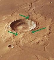
New press release. "The flood after the impact".
Like the commenters, I think the description is wrong. The crater came after the river, not the other way around. Even a non-geologist like me can see that the river flowed from left to right, towards the crater. And a quick look in Google-mars clearly shows where the riverbed originated; a fissure to the south, not that crater. Also, this is Hebrus Valles, not Hephaestus Fossae. |
|
|
|
|
Feb 11 2014, 09:32 PM
Post
#42
|
|
 Senior Member Group: Members Posts: 2173 Joined: 28-December 04 From: Florida, USA Member No.: 132 |
QUOTE (OWW @ Feb 11 2014, 01:57 PM) ... Even a non-geologist like me can see that the river flowed from left to right, towards the crater.... You may well be right. However as this non-geologist sees it, if an impact melts a large area of subsurface ice, the rivers formed will flow downhill whether that is toward or away from the crater. And the water from the subsurface melt will escape to the surface via the route of least resistance which may be a preexisting fissure. |
|
|
|
|
Feb 11 2014, 10:18 PM
Post
#43
|
|
|
Member Group: Members Posts: 710 Joined: 28-September 04 Member No.: 99 |
QUOTE (centsworth_II @ Feb 11 2014, 10:32 PM) You may well be right. However as this non-geologist sees it, if an impact melts a large area of subsurface ice, the rivers formed will flow downhill whether that is toward or away from the crater. And the water from the subsurface melt will escape to the surface via the route of least resistance which may be a preexisting fissure. If this were the case, wouldn't the river flow around the rim (or lobes) of this large fresh crater? I don't see any sign of that in the image; no erosion. |
|
|
|
|
Feb 11 2014, 10:26 PM
Post
#44
|
|
 Member Group: Members Posts: 754 Joined: 9-February 07 Member No.: 1700 |
And today's trip to UMSF causes brellis to learn more about the Coriolis Effect, because I was going to ask in which direction the 'river' should be traveling. Thanks!
p.s. - I must confess I was wondering about compass-type of stuff at the time, lol |
|
|
|
|
Feb 12 2014, 03:21 AM
Post
#45
|
||
|
Senior Member Group: Members Posts: 2173 Joined: 28-December 04 From: Florida, USA Member No.: 132 |
QUOTE (OWW @ Feb 11 2014, 05:18 PM) If this were the case, wouldn't the river flow around the rim (or lobes) of this large fresh crater? I don't see any sign of that in the image; no erosion. Not around the crater, but I've marked what looks like flow out of the crater. Was the crater like an overflowing well?
http://www.esa.int/spaceinimages/Images/20...erspective_view |
|
|
|
|
|
|

|
Lo-Fi Version | Time is now: 24th September 2024 - 08:26 PM |
|
RULES AND GUIDELINES Please read the Forum Rules and Guidelines before posting. IMAGE COPYRIGHT |
OPINIONS AND MODERATION Opinions expressed on UnmannedSpaceflight.com are those of the individual posters and do not necessarily reflect the opinions of UnmannedSpaceflight.com or The Planetary Society. The all-volunteer UnmannedSpaceflight.com moderation team is wholly independent of The Planetary Society. The Planetary Society has no influence over decisions made by the UnmannedSpaceflight.com moderators. |
SUPPORT THE FORUM Unmannedspaceflight.com is funded by the Planetary Society. Please consider supporting our work and many other projects by donating to the Society or becoming a member. |
|