MSL Route Map |

  |
MSL Route Map |
 Jul 14 2016, 06:59 PM Jul 14 2016, 06:59 PM
Post
#826
|
||
|
Solar System Cartographer  Group: Members Posts: 10153 Joined: 5-April 05 From: Canada Member No.: 227 |
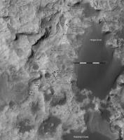
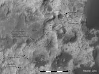
Map updated to sol 1400 with a few corrections on the recent drives.
Phil
-------------------- ... because the Solar System ain't gonna map itself.
Also to be found posting similar content on https://mastodon.social/@PhilStooke Maps for download (free PD: https://upload.wikimedia.org/wikipedia/comm...Cartography.pdf NOTE: everything created by me which I post on UMSF is considered to be in the public domain (NOT CC, public domain) |
|
 |
 
|
|
|
Jul 15 2016, 07:45 PM
Post
#827
|
||
|
Solar System Cartographer Group: Members Posts: 10153 Joined: 5-April 05 From: Canada Member No.: 227 |
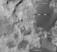
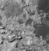
Sol 1401 - a drive south and then southwest a bit, nicely revealed by tracks.
Phil
-------------------- ... because the Solar System ain't gonna map itself.
Also to be found posting similar content on https://mastodon.social/@PhilStooke Maps for download (free PD: https://upload.wikimedia.org/wikipedia/comm...Cartography.pdf NOTE: everything created by me which I post on UMSF is considered to be in the public domain (NOT CC, public domain) |
|
|
|
|
|
|
Jul 16 2016, 07:22 PM
Post
#828
|
||
|
Solar System Cartographer Group: Members Posts: 10153 Joined: 5-April 05 From: Canada Member No.: 227 |
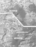
It's time for one of my very infrequent overview maps of activities in the last 150 sols. The square grid has 100 m spacing, with distance labels counted from the landing site. Despite the fact that the bases are orthophotos which should remove relief distortion, there are always residual distortions, so the grid line positions may be slightly off, but they give a reasonable estimate of distances from the landing site. Black dots are end of drive positions, white squares are the main science stops (basically anything involving the arm, including DRT, MAHLI and APXS, but possibly I have missed one or two sites where only MAHLI was used).
Phil
-------------------- ... because the Solar System ain't gonna map itself.
Also to be found posting similar content on https://mastodon.social/@PhilStooke Maps for download (free PD: https://upload.wikimedia.org/wikipedia/comm...Cartography.pdf NOTE: everything created by me which I post on UMSF is considered to be in the public domain (NOT CC, public domain) |
|
|
|
|
|
|
Jul 20 2016, 09:28 PM
Post
#829
|
||
|
Solar System Cartographer Group: Members Posts: 10153 Joined: 5-April 05 From: Canada Member No.: 227 |
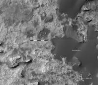
On the road again! Sol 1405, around the corner and up to the southern edge of Bimbe.
Phil
-------------------- ... because the Solar System ain't gonna map itself.
Also to be found posting similar content on https://mastodon.social/@PhilStooke Maps for download (free PD: https://upload.wikimedia.org/wikipedia/comm...Cartography.pdf NOTE: everything created by me which I post on UMSF is considered to be in the public domain (NOT CC, public domain) |
|
|
|
|
|
|
Jul 22 2016, 10:29 PM
Post
#830
|
|
 Member Group: Members Posts: 890 Joined: 15-June 09 From: Lisbon, Portugal Member No.: 4824 |
It took me longer than I expected to "come back to operations". After some vacation I found myself really busy. Then things pile up. There was a lot to catch up with, here and in other threads. With recourse to Phil's maps, the JPL site, and Paul and Jan's images, I managed to finally update MSL's route to sol 1405.
I did notice the route change for sol 1376, from the images posted for sol 1378 and for sol 1383, but I did not implement it. PDS release 12, due on August 1st, will not cover up to that sol, but Release 13, due on December 5, will. If the change is in that data I'll pick it up automatically. Fernando Update to sol 1405:  The_Martian_Way_MSL_Curiosity_Sol_1405_2016JUL22.kmz ( 406.72K )
Number of downloads: 372
The_Martian_Way_MSL_Curiosity_Sol_1405_2016JUL22.kmz ( 406.72K )
Number of downloads: 372 |
|
|
|
|
Jul 25 2016, 05:50 PM
Post
#831
|
||
|
Solar System Cartographer Group: Members Posts: 10153 Joined: 5-April 05 From: Canada Member No.: 227 |
We had a good drive to the southwest, nearly 60 m, as Midnight Planets informed us. Here is the updated map. The path is only a guess so far.
Phil
-------------------- ... because the Solar System ain't gonna map itself.
Also to be found posting similar content on https://mastodon.social/@PhilStooke Maps for download (free PD: https://upload.wikimedia.org/wikipedia/comm...Cartography.pdf NOTE: everything created by me which I post on UMSF is considered to be in the public domain (NOT CC, public domain) |
|
|
|
|
|
|
Jul 27 2016, 01:34 PM
Post
#832
|
|
|
Member Group: Members Posts: 890 Joined: 15-June 09 From: Lisbon, Portugal Member No.: 4824 |
Update to sol 1410 plus provisional to sol 1412 (based on some poorly stitched images).
Fernando
The_Martian_Way_MSL_Curiosity_Sol_1412_2016JUL27.kmz ( 408.58K )
Number of downloads: 325 |
|
|
|
|
Jul 28 2016, 04:23 AM
Post
#833
|
||
|
Solar System Cartographer Group: Members Posts: 10153 Joined: 5-April 05 From: Canada Member No.: 227 |
Update to sol 1412. I may have been only 10 cm out in my distance (see other thread) but I was 20 m out in my tentative location, so it was a pure fluke. Good job I refrained from posting until Tim Parker at JPL could set me straight.
Phil
-------------------- ... because the Solar System ain't gonna map itself.
Also to be found posting similar content on https://mastodon.social/@PhilStooke Maps for download (free PD: https://upload.wikimedia.org/wikipedia/comm...Cartography.pdf NOTE: everything created by me which I post on UMSF is considered to be in the public domain (NOT CC, public domain) |
|
|
|
|
|
|
Jul 29 2016, 06:53 PM
Post
#834
|
||
|
Solar System Cartographer Group: Members Posts: 10153 Joined: 5-April 05 From: Canada Member No.: 227 |
This time a good position, but a guessed path. Sol 1414.
Phil
-------------------- ... because the Solar System ain't gonna map itself.
Also to be found posting similar content on https://mastodon.social/@PhilStooke Maps for download (free PD: https://upload.wikimedia.org/wikipedia/comm...Cartography.pdf NOTE: everything created by me which I post on UMSF is considered to be in the public domain (NOT CC, public domain) |
|
|
|
|
|
|
Aug 2 2016, 05:08 PM
Post
#835
|
||
|
Solar System Cartographer Group: Members Posts: 10153 Joined: 5-April 05 From: Canada Member No.: 227 |
Update to sol 1417. I have extended this to include Sossus Vlei, which had been promoted as a second dune study site (Bridges et al. abstract at LPSC) but which looks as if it may be bypassed now.
Phil
-------------------- ... because the Solar System ain't gonna map itself.
Also to be found posting similar content on https://mastodon.social/@PhilStooke Maps for download (free PD: https://upload.wikimedia.org/wikipedia/comm...Cartography.pdf NOTE: everything created by me which I post on UMSF is considered to be in the public domain (NOT CC, public domain) |
|
|
|
|
|
|
Aug 6 2016, 03:04 AM
Post
#836
|
|
|
Member Group: Members Posts: 890 Joined: 15-June 09 From: Lisbon, Portugal Member No.: 4824 |
It was four years ago today ...
Update to sol 1417. Congratulations to the team and Many Happy Returns, Curiosity.
The_Martian_Way_MSL_Curiosity_Sol_1417_2016AUG06.kmz ( 409.1K )
Number of downloads: 421 |
|
|
|
|
Aug 6 2016, 08:19 AM
Post
#837
|
|
|
Newbie Group: Members Posts: 3 Joined: 5-July 16 From: France Member No.: 7989 |
Excuse me, with what application opens this file ".kmz" please ? Thank you !
-------------------- [color="#0000FF"][/color][size="4"][/size]Viking on Mars 1976-2016
|
|
|
|
|
Aug 6 2016, 09:38 AM
Post
#838
|
|
 Senior Member Group: Members Posts: 2428 Joined: 30-January 13 From: Penang, Malaysia. Member No.: 6853 |
QUOTE (Geopardy @ Aug 6 2016, 04:19 PM)  Excuse me, with what application opens this file ".kmz" please ? Thank you ! The file opens in 'Google Earth' when installed on a computer. It does not run on mobile operating systems which use a cut down version of Google Earth. So install Google Earth, then double click the .zmz file, Google Earth will do the rest. |
|
|
|
|
Aug 6 2016, 01:55 PM
Post
#839
|
|
|
Member Group: Members Posts: 890 Joined: 15-June 09 From: Lisbon, Portugal Member No.: 4824 |
|
|
|
|
|
Aug 6 2016, 02:34 PM
Post
#840
|
||
|
Member Group: Members Posts: 890 Joined: 15-June 09 From: Lisbon, Portugal Member No.: 4824 |
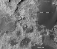
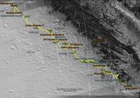
Here is MSL "Curiosity"'s full 4-year traverse, with some milestones and major locations.
Fernando
|
|
|
|
|
|
|

|
Lo-Fi Version | Time is now: 28th April 2024 - 12:53 AM |
|
RULES AND GUIDELINES Please read the Forum Rules and Guidelines before posting. IMAGE COPYRIGHT |
OPINIONS AND MODERATION Opinions expressed on UnmannedSpaceflight.com are those of the individual posters and do not necessarily reflect the opinions of UnmannedSpaceflight.com or The Planetary Society. The all-volunteer UnmannedSpaceflight.com moderation team is wholly independent of The Planetary Society. The Planetary Society has no influence over decisions made by the UnmannedSpaceflight.com moderators. |
SUPPORT THE FORUM Unmannedspaceflight.com is funded by the Planetary Society. Please consider supporting our work and many other projects by donating to the Society or becoming a member. |
|