Mars 2020 - Perseverance data in the PDS and the Analyst's Notebook, Working with the archived science & engineering data |

Mars 2020 - Perseverance data in the PDS and the Analyst's Notebook, Working with the archived science & engineering data |
 Aug 21 2021, 02:25 PM Aug 21 2021, 02:25 PM
Post
#1
|
|
 Member  Group: Members Posts: 893 Joined: 15-June 09 From: Lisbon, Portugal Member No.: 4824 |
PDS has released its first set of Mars 2020 Perseverance data.
Meanwhile, the Analyst's Nobebook for Perseverance is still "under construction". Here is the full text of the release: The NASA Planetary Data System announces the first release of data from the Mars 2020 Perseverance Rover mission to Mars. This release contains raw, calibrated, and derived data products covering the first 90 sols of the mission, February 18 to May 20, 2021. The data are archived at various PDS Nodes. Links to all the archives can be found at |
 |
 
|
 |
|
Aug 21 2021, 07:21 PM
Post
#2
|
|
|
Member Group: Members Posts: 406 Joined: 18-September 17 Member No.: 8250 |
Great stuff.
Full resolution EDL raw videos look awesome - no YouTube/Twitter re-compression artifacts. Thumbnail videos include some new footage (ddc_00000005_020_000000.mp4 has more movement of exterior lighting). https://pds-imaging.jpl.nasa.gov/data/mars2...document_video/ |
|
|
|
|
Aug 21 2021, 10:18 PM
Post
#3
|
|
 Newbie Group: Members Posts: 8 Joined: 21-February 21 Member No.: 8960 |
Amazing. The documentation looks amazing, they really nailed it this time!
I am extremely happy they got around to publishing what the pipeline looked like https://pds-geosciences.wustl.edu/m2020/urn...peline_Flow.pdf I wonder, was there ever a similar document released for MSL or MER missions? |
|
|
|
|
Aug 27 2021, 04:00 AM
Post
#4
|
||
|
Member Group: Members Posts: 248 Joined: 25-February 21 From: Waltham, Massachussetts, U.S.A. Member No.: 8974 |
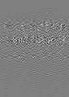
PDS now also has the first RIMFAX (radar) data, and I started to look at browse images (see map thread). The browse images have full horizontal resolution and somewhat limited vertical resolution (reduced by a factor of 8). They are very contrast stretched.
It turns out it is very possible to turn the calibrated sounding data in the csv file into images. I ended up using this script: CODE #!/bin/bash # usage: csv2pgm.sh < rimfax_calibrated_IN.csv > rimfax_calibrated_OUT.pgm export TEMP=csv2pgm.tmp # extract Shallow mode and ignore calibration records # field 91 is where the data start grep Shallow, | grep XM | cut -d"," -f91- > $TEMP export height=`wc $TEMP | awk '{print $1}'` export width=`head -1 $TEMP | awk -F"," '{print NF}'` #echo $width $height # use numeric sort to find min. and max. tr , \\n < $TEMP | awk '{printf "%f\n", $1}' | sort -h > S$TEMP export min=`head -1 S$TEMP` export max=`tail -1 S$TEMP` #echo $min $max # use awk to generate plain pgm format. Just normalize to one value per line, and normalize the values to 2 bytes. tr , \\n < $TEMP | awk -F, -v width=$width -v height=$height -v min=$min -v max=$max '\ BEGIN { print "P2" print width, height maxC = 65535 s = maxC / (max - min) print maxC } {print int(s * ($1 - min) + 0.5)} ' | pnmflip -xy | pnmscale 1 rm $TEMP S$TEMP It is centered around creating a plain pgm format image which is a very simple format and close to the csv data. The resulting file preserves 2 byte gray values which is nice. Gimp and probably Imagemagick understand the format, and there are many netpbm tools for it. Using the script I could reproduce browse images, so I am pretty sure it is correct. I will convert all available recordings soon. Here is an example of sol 65, without stretching and double vertical resolution (lower section removed):
-------------------- --
Andreas Plesch, andreasplesch at gmail dot com |
|
|
|
|
|
|
Oct 15 2021, 04:40 PM
Post
#5
|
|||
 Member Group: Members Posts: 665 Joined: 9-May 21 From: Germany Member No.: 9017 |
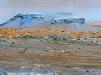
The problem of inhomogeneous filter flatfields in raw images no longer exists in the radiation calibrated (RAD) images available in the Planetary Data System (PDS) Geosciences Node.
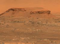
Here is an infrared multispectral false-color image, created from sol 69 Mastcam-Z right eye infrared filters 1 to 6 radiation calibrated images using principal components analysis. The foreground in the lower halfth of the first image with bluish-gray rocks belongs to the basaltic unit. The rocks in Séítah show a yellow-orange false color. Kodiak hill stands out with a blue false color. So we have at least three different rock types in this image. The second image is the Mastcam-Z right eye filter 0 (visible RGB) RAD image (with increased brightness) for comparison. Séítah and the basaltic foreground are almost indistinguishable in visible RGB colors.
|
||
|
|
|
||
|
Nov 23 2021, 05:43 AM
Post
#6
|
|
 Senior Member Group: Members Posts: 2428 Joined: 30-January 13 From: Penang, Malaysia. Member No.: 6853 |
PDS release 2 covering sols 90 - 179 (November 22, 2021) is now available link
|
|
|
|
|
Nov 24 2021, 01:00 AM
Post
#7
|
|
|
Solar System Cartographer Group: Members Posts: 10157 Joined: 5-April 05 From: Canada Member No.: 227 |
Let me recommend this specific page:
https://pds-geosciences.wustl.edu/m2020/urn...ta_special_rmi/ All RMI mosaics with target names. If you are looking for names as I always am, this is gold. I am just in the process of getting them onto the maps. There will be other names associated with Mastcam-Z targets and WATSON targets but this is a good start. The Analyst's Notebook is not up yet but will be soon with limited functionality, and ultimately that will give all names. Phil -------------------- ... because the Solar System ain't gonna map itself.
Also to be found posting similar content on https://mastodon.social/@PhilStooke Maps for download (free PD: https://upload.wikimedia.org/wikipedia/comm...Cartography.pdf NOTE: everything created by me which I post on UMSF is considered to be in the public domain (NOT CC, public domain) |
|
|
|
|
Nov 24 2021, 04:21 AM
Post
#8
|
|
|
Senior Member Group: Members Posts: 2428 Joined: 30-January 13 From: Penang, Malaysia. Member No.: 6853 |
QUOTE (Phil Stooke @ Nov 24 2021, 09:00 AM)  Let me recommend this specific page: https://pds-geosciences.wustl.edu/m2020/urn...ta_special_rmi/ All RMI mosaics with target names. If you are looking for names as I always am, this is gold. I am just in the process of getting them onto the maps. There will be other names associated with Mastcam-Z targets and WATSON targets but this is a good start. The Analyst's Notebook is not up yet but will be soon with limited functionality, and ultimately that will give all names. Phil Thanks Phil, Can you kindly check the link? I'm getting: "Page is down.... Service Unavailable HTTP Error 503. The service is unavailable." I'll try again later in case it's temporary... Cheers Paul |
|
|
|
|
Nov 24 2021, 06:38 PM
Post
#9
|
|
|
Solar System Cartographer Group: Members Posts: 10157 Joined: 5-April 05 From: Canada Member No.: 227 |
It's fine now.
Phil -------------------- ... because the Solar System ain't gonna map itself.
Also to be found posting similar content on https://mastodon.social/@PhilStooke Maps for download (free PD: https://upload.wikimedia.org/wikipedia/comm...Cartography.pdf NOTE: everything created by me which I post on UMSF is considered to be in the public domain (NOT CC, public domain) |
|
|
|
|
Dec 9 2021, 08:15 PM
Post
#10
|
|
|
Solar System Cartographer Group: Members Posts: 10157 Joined: 5-April 05 From: Canada Member No.: 227 |
Just a heads up that the Analyst's Notebook for Perseverance is now up. No targets, but day to day activity summaries. I will be looking for names.
Phil -------------------- ... because the Solar System ain't gonna map itself.
Also to be found posting similar content on https://mastodon.social/@PhilStooke Maps for download (free PD: https://upload.wikimedia.org/wikipedia/comm...Cartography.pdf NOTE: everything created by me which I post on UMSF is considered to be in the public domain (NOT CC, public domain) |
|
|
|
 |

|
Lo-Fi Version | Time is now: 4th May 2024 - 02:46 PM |
|
RULES AND GUIDELINES Please read the Forum Rules and Guidelines before posting. IMAGE COPYRIGHT |
OPINIONS AND MODERATION Opinions expressed on UnmannedSpaceflight.com are those of the individual posters and do not necessarily reflect the opinions of UnmannedSpaceflight.com or The Planetary Society. The all-volunteer UnmannedSpaceflight.com moderation team is wholly independent of The Planetary Society. The Planetary Society has no influence over decisions made by the UnmannedSpaceflight.com moderators. |
SUPPORT THE FORUM Unmannedspaceflight.com is funded by the Planetary Society. Please consider supporting our work and many other projects by donating to the Society or becoming a member. |
|