Printable Version of Topic
Click here to view this topic in its original format
Unmanned Spaceflight.com _ InSight _ InSight Cruise Phase
Posted by: nprev May 8 2018, 05:35 AM
Hey again, everyone. This thread will be for discussion of anything that happens between now & landing day, currently 26 Nov US Pacific time (UTC-8 hrs during that part of the year).
Posted by: Tycho May 10 2018, 08:27 PM
Just to put it in my calendar: Is it possible to already determine at what time exactly the landing will happen? Does anybody know?
Posted by: Phil Stooke May 10 2018, 08:41 PM
hasty reply deleted!
Phil
Posted by: mcaplinger May 10 2018, 09:25 PM
Press kit says Nov. 26, 2018, about noon PST (3 p.m. EST; 20:00 UTC).
Posted by: nprev May 11 2018, 12:01 AM
Just out of curiosity <rimshot>, how much control over the landing date & time does InSight really have? Since it's a direct EDL I can't see the possible variance being more than a few minutes at most else it would miss the target area completely. Also, I'm sure that the amount of attitude control propellant on board is just enough to get that specific job done throughout cruise and entry with perhaps a small contingency reserve for leaks, etc.
Posted by: djellison May 11 2018, 12:25 AM
The TCMs between now and entry are not only designed to reach the appropriate target - but to do so at the exact right time. If you're targetting the landing ellipse at the wrong time, they your entry angle will be bad. If you target the right entry angle, but at the wrong time...you won't be landing in your ellipse...and so on and so on.
Timing is also crucial so that MRO will be in the right place to record UHF telemetry during EDL (MRO can only store and forward that data - no realtime bent-pipe)
Hopefully, if they make it, the MarCOs WALL-E and Eva will conduct bent pipe realtime UHF to XBand!
Posted by: nprev May 11 2018, 03:49 AM
Got it, and thanks for the great details, Doug. So, there is very little flex possible (none, really; it's all about error correction).
X-band...yes, please, and here's rooting for the MarCOs! A bit surprised that MRO doesn't have a bent pipe capability while MODY does, but I assume that's probably because a- MRO's primary mission payloads took up the mass budget and b- nobody seriously thought at the time that we'd have more than one operational surface asset AT a time for long enough to justify it.
Posted by: Explorer1 May 11 2018, 04:13 AM
There is a bit of margin in terms of inclement weather though, right? If I recall, was it Spirit's landing that was modified a bit in the exact timing of certain sequences due to dust storms? Or was that Curiosity?
Posted by: djellison May 11 2018, 05:06 AM
A shift in when to deploy the parachute.....but not a shift to the entry time and entry attitude. The landing time will remain unchanged to within a few seconds.
Posted by: djellison May 11 2018, 05:10 AM

So - as I understand it - MRO could, kind of, do a semi immediate store and forward approximating a bent pipe. It's not a mass problem. (TGO and MAVEN have basically the same UHF antenna and Electra radio system).
BUT - the choice has been made to record data in an open loop canister mode. Not immediately decoding the 1's and 0's - but recording all the Electra can hear. This entire data set will then be dumped back to Earth enabling a deeper analytical dive into the data if something goes wrong, and to throw computationally intensive analysis at it that MRO couldn't do in real time.
Back when MSL landed - MRO was doing the same thing, but Odyssey was also overhead doing the bent pipe. If you could only have one - you would take the recorded data because while it lacks immediacy of bent pipe....it makes up for it in potential to have more useful information after the fact.
The relevant facts start on page 28 - https://descanso.jpl.nasa.gov/DPSummary/MRO_092106.pdf
The MRO - MSL Mode is discussed on page 108 - https://descanso.jpl.nasa.gov/DPSummary/Descanso14_MSL_Telecom.pdf
"MRO cannot provide delay-free (bent-pipe) relay, as it first records the return-link relay data as it
is received from the descending spacecraft during the overflight and then sends the data to the
DSN. Both telemetry relay (specifically, unreliable bit-stream reception at MRO for EDL and the
Proximity 1 protocol [6F26] for normal relay) and open-loop recording (known as canister mode in
CE505 radio terminology) are being considered for the relay reception onboard MRO. The
current baseline is open-loop recording on MRO during EDL. However, open-loop recording
was successful during Phoenix EDL. MSL will choose either Prox-1 unreliable or open loop for
EDL in 2012 based on the predicted link signal level and variability.
"
This... https://ipnpr.jpl.nasa.gov/progress_report/42-197/197A.pdf appears to discuss it after the fact on page 6
"The UHF signal emitted by MSL was received by MROs Electra radio. The in-phase and
quadrature components of the signal were recorded on board MRO in open-loop fashion.
These signal data were relayed to a NASA DSN antenna on Earth over MROs DTE X-band
telemetry link. The spectra extracted from the open-loop data as a function of time were
examined and processed at different bandwidths to extract carrier-to-noise ratio (CNR) and
frequency estimates"
Posted by: nprev May 11 2018, 07:14 PM
Rocketcam video of launch and spacecraft separation:
https://spaceflightnow.com/2018/05/11/video-rocketcam-replay-of-insights-launch-to-mars/
Posted by: Explorer1 May 11 2018, 08:02 PM
https://spaceflightnow.com/2018/05/11/video-rocketcam-replay-of-insights-launch-to-mars/
Farewell InSight! Safe travels!
And not to be seen again by human eyes until the first good HiRise pass in November...
Posted by: Decepticon May 14 2018, 04:17 AM
https://spaceflightnow.com/2018/05/11/video-rocketcam-replay-of-insights-launch-to-mars/
Was this shown Live?
I don't remember seeing this!?
Posted by: Explorer1 May 14 2018, 02:09 PM
No, it was released a few days later.
Posted by: Explorer1 May 16 2018, 05:01 AM
First light from the cubesats: https://www.jpl.nasa.gov/news/news.php?release=2018-099&rn=news.xml&rst=7124
If all goes well in November, we might very well get a pale red dot too... getting larger and larger...
Posted by: propguy May 24 2018, 07:00 PM
TCM1 was completed 5/22 (yeah!).  Press release at: https://www.jpl.nasa.gov/news/news.php?feature=7138
Can't provide much more data than in the news release but the S/C performance was great and we hit the desired DV well within 1 sigma. Very healthy spacecraft and now we are on a path to Mars! Lots to do in the coming months, but so far a really smooth cruise!
Posted by: nprev May 25 2018, 12:42 AM
Music to our ears, Propguy; thank you!!! 
Posted by: MahFL May 25 2018, 12:53 AM
Press release at: https://www.jpl.nasa.gov/news/news.php?feature=7138 Can't provide much more data than in the news release but the S/C performance was great and we hit the desired DV well within 1 sigma. Very healthy spacecraft and now we are on a path to Mars! Lots to do in the coming months, but so far a really smooth cruise!
Good to hear.
Posted by: Explorer1 Jun 2 2018, 12:23 AM
The cubesats have done their TCMs as well ( https://www.jpl.nasa.gov/news/news.php?release=2018-123 )
Looks like B has a leaky valve, but it should be able to make it as well (showing how useful twin spacecraft are!)
Posted by: PaulH51 Aug 21 2018, 01:13 AM
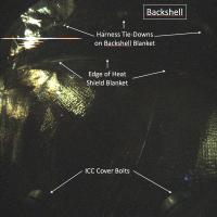
InSight's Inner Sanctum Revealed (PIA22647): This long-exposure image (24 seconds) was taken by Instrument Context Camera (ICC) of NASA's InSight Mars lander. The image shows some of the interior features of the backshell that encapsulates the spacecraft. The backshell carries the parachute and several components used during later stages of entry, descent, and landing. Along with the heatshield, the backshell protects NASA's InSight Mars lander during its commute to and entry into the Martian atmosphere. The annotations in this image call out discernable components in the backshell -- the heatshield blanket, harness tie-downs, and cover bolts for the ICC. The heat shield blanket provides thermal protection from the hot and cold temperature swings encountered during cruise, and the high heat that will occur during Mars atmospheric entry. The tie-downs are used to secure harnesses (or other objects) so they do not move around inside the aeroshell while in flight. The ICC cover bolts secure a protective transparent window to the camera during cruise and entry, descent and landing. The cover is opened after landing and is not visible during surface operations. This image has been stretched to bring out details in the dimly lit scene. The illumination of the components on the inside of the backshell comes from sunlight entering around the edges of cutouts in the backshell to accommodate steering thrusters. https://photojournal.jpl.nasa.gov/catalog/PIA22647

|
|
EDIT: Not sure why I cant see the images in this post, they looked fine in the preview, but are not shown. I'm seeing them as downloads, but I cant download them. I removed and re uploaded them but the issue remains. You can get both images from the link to the Photojournal post.
Posted by: Phil Stooke Oct 24 2018, 02:00 AM
Do we know anything yet about the image release policy for Insight? I would hope we will see all images released quickly, as we have come to expect from NASA Mars missions. Hopeful cartographers need to know!
Phil
Posted by: MahFL Oct 26 2018, 12:09 AM
Any news on Insight being updated on Eyes, so we can watch the approach and landing ?
Posted by: Hungry4info Oct 26 2018, 01:10 AM
I'm certainly looking forward to your routemaps

Posted by: djellison Oct 28 2018, 03:02 PM
Not going to happen Im afraid - there just arent the resources to pull it off.
Posted by: mcmcmc Oct 29 2018, 02:49 PM
I don't know where he gets the data, anyway here they are:
http://www.whereisroadster.com/insight/
I'll see if I can turn them into something more graphical like I did for https://programmi.000webhostapp.com/hayabusa2/simulator/simulator3.html and https://programmi.000webhostapp.com/osiris/osiris-counter.html.
Posted by: Explorer1 Oct 31 2018, 06:07 PM
InSight press conference on now, everything with the spacecraft remains nominal. Newest thing is confirming MRO will try to image the landing (and I can update my avatar at last)!
Posted by: mcmcmc Nov 7 2018, 07:07 PM
Insight will have same EDL profile of Phoenix, so while we wait for november 26th we can imagine how it will be: this video mixes real mission control audio+video with video simulation to show what happened 10 years ago and what will happen 3 weeks from now:
https://www.youtube.com/watch?v=hH5pNFROlYU
Note: for some reasons, the "freefall phase" after parachute jettisoning is not called like that for Insight, but instead called "gravity turn"; then engines are started ("Powered descent phase"), and after 3 seconds of freefall+deceleration Insight will enter the "Constant velocity phase"; once Insight slows down to 30 km/h (around 50m from ground) it turns on ground contact sensors on legs; at 8 km/h engines are turned off, to prevent too much regolite from being blown around, and a final free-fall (few centimeters) starts, and we are on Mars.
This document analyses actual Phoenix EDL recorded data:
https://ntrs.nasa.gov/archive/nasa/casi.ntrs.nasa.gov/20080034645.pdf
Reconstructed Insight timeline (from multiple inconsistent sources):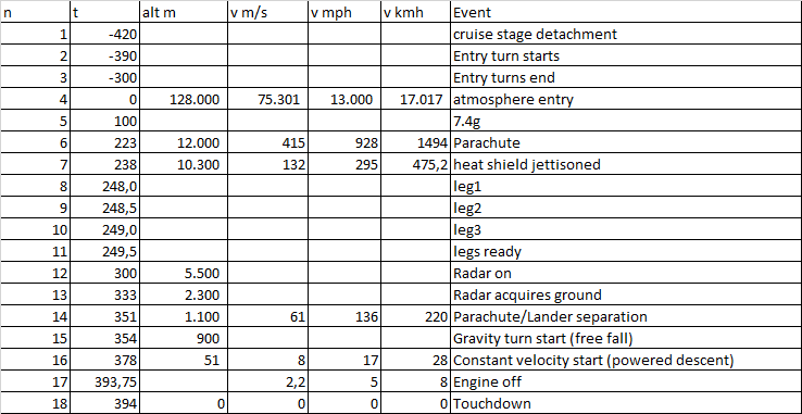
Text version:
1 -420 cruise stage detachment
2 -390 Entry turn starts
3 -300 Entry turns end
4 0 128000 75301 13000 17017 atmosphere entry
5 100 7.4g
6 223 12000 415 928 1494 Parachute
7 238 10300 132 295 475.2 heat shield jettisoned
8 248.0 leg1
9 248.5 leg2
10 249.0 leg3
11 249.5 legs ready
12 300 5500 Radar on
13 333 2300 Radar acquires ground
14 351 1100 61 136 220 Parachute/Lander separation
15 354 900 Gravity turn start (free fall)
16 378 51 8 17 28 Constant velocity start (powered descent)
17 393.75 2.2 5 8 Engine off
18 394 0 0 0 0 Touchdown
Status monitor:
http://win98.altervista.org/space/exploration/
Phoenix EDL analysis:

Sources:
https://www.seis-insight.eu/en/public-2/the-insight-mission/landing
https://mars.nasa.gov/insight/timeline/landing/entry-descent-landing/
https://www.jpl.nasa.gov/news/press_kits/insight/assets/images/mission/Layer-2.jpg
Posted by: propguy Nov 9 2018, 09:11 PM
Actually gravity turn is not a freefall. There is a very short freefall once we separate from the backshell and parachute (~0.5 second) and then we begin the tip-up portion of powered descent. That lasts ~2.5 seconds (the tip-up is the align the lander with the velocity vector, which should still have some appreciable horizontal velocity, whereas when we drop out of the backshell we will mostly be dropping down). Then we begin gravity turn which is the main portion of powered descent where we are eliminating the horizontal velocity and reducing vertical velocity down to 2.5 m/sec or so. After we hit that vertical velocity limit we enter the final phase of powered descent called constant velocity. Constant velocity is where we descend at the 2.5 m/sec rate until one of the three legs achieves contact with the surface and the descent engines are then turned off. This is one of the keys to powered descent. The main goal is to achieve constant velocity not too close to the surface (or you risk hitting at too high a speed) or too high (or you end up using too much fuel since you have a very long time at this slow descent rate). As shown in the above Phoenix diagram we spend a third of powered descent in constant velocity while only descending the last 50 meters or so (luckily also at a lower thrust since at this point we only have to thrust at a value equal to the Mars gravity of the lander, so fuel usage is lower). So to summarize, the freefall begins at separation from the backshell and parachute, followed by tip-up, then gravity turn, and then constant velocity, and then landing (Whoohoo!).
Here is a little InSight summary too (without providing any true details, which I am not allowed to provide, that must come from official sources). We are as you know nearing Mars. S/C is performing beautifully. We have 3 potential maneuvers left (TCM4, 5, and 6) set on the next 3 Sundays (11/11, 18, and 25). These are only required to fine tune the entry location and time (i.e. TCM3 pointed us at the correct location, these are used to adjust for errors in final arrival location). This is the same plan that Phoenix had and they only performed the middle one (TCM5). If I were to guess I think that may be or path to entry too, but that is simply a guess. Also today I am reviewing the final EDL sequence for upload (one of the many reviewers who have to approve) and that should go up in the next week (same sequence we have had for a while, we just rerun one final time with the latest vehicle state and entry parameters for timing). Starting to get very real and will be quite busy in 2 weeks as we get ready for entry.
P.S. My company has put out a website about InSight EDL and it has lots of facts plus a podcast I am in with one of our system engineers. You can even see what I look like (I am the guy in the dark shirt on the right in the photo). I hope you find the website interesting.
Go InSight and Go Marco! (so hopefully we get real time EDL data just like we did on Phoenix).
https://www.lockheedmartin.com/en-us/news/features/2018/returning-to-mars.html
Posted by: mcmcmc Nov 13 2018, 01:16 PM
Thanks, very interesting. NASA site has a lot of pictures but very few science/engineering data!
I really would like to setup a simulator for Insight http://programmi.000webhostapp.com/osiris/osiris-counter.html, but specifically for Insight EDL, with multiple countdowns for each phase. I was thinking about synching it with youtube animation of EDL. Synching it also to realtime telemetries would be great! I don't know if it is feasible in just 12 days, but I want to try.
Planned development phases:
1) Setup multicounter page - quick & easy once I have the timeline... which I posted above.
2) Synch to youtube - I need to study youtube API and find the most suitable video/animation of Insight; looks quite feasible in time.
3) Synch to realtime telemetries - Possible only if:
a) fast network available
B) official json data available
c) anonymous CORS access to data allowed
d) only main events shown (at least 10 seconds one from the other)
Do you think you could setup in such a short time a json URL with realtime telemetries?
Posted by: mcaplinger Nov 13 2018, 03:22 PM
Not to rain on your parade, but this is extremely unlikely to happen. For past missions the EDL data were released to PDS years after the landing. Even the MSL landing simulation on Eyes wasn't based on realtime data AFAIK.
Posted by: mcmcmc Nov 13 2018, 03:40 PM
He said "so hopefully we get real time EDL data just like we did on Phoenix"; assuming that people officially involved in the uploading EDL firmware will receive realtime telemetry by sure, I deduced he was talking abouth something like publishing realtime telemetries. Did it happen for Phenix?
Anyway, telemetries of "just" surface operations like initially happened for Philae would be good too. :-) (I followed in realtime the depletion of the battery... until DLR cut the feed :-( )
Posted by: mcaplinger Nov 13 2018, 04:03 PM
No.
Posted by: propguy Nov 13 2018, 04:22 PM
Anyway, telemetries of "just" surface operations like initially happened for Philae would be good too. :-) (I followed in realtime the depletion of the battery... until DLR cut the feed :-( )
Sorry to create confusion. By real time telemetry I mean that we on the ops team would see real time UHF telemetered EDL data through the Marco small sats. On Phoenix we got a real time link through Odyssey (it was very cool to see the real time data, I remember thinking, wow I'm seeing data from a spacecraft on a parachute over Mars!). If the Marco links do not work we will still get the open loop recording of the UHF data stream from MRO (the program decided to record the open loop stream, then if there were any issues the full transmitted stream would be available for data extraction). That will downlink later in the day for review by the ops team. Of course with a successful landing we will also get the playback of the data in the first Odyssey pass about 5 1/2 hours after landing, so the MRO data is primarily for anomaly review.
Of course the real time data is not something that will be available outside of the project. When and how they will publish that data is not something I know anything about. Sorry to provide a false hope of seeing this data on NASA TV or other sources. Any animation you see of EDL will be purely open loop with estimated timelines from prior to EDL. Assuming we do get the UHF data in real time there should still be a running status of the EDL progress over NASA TV (as you are used to with Phoneix and MSL). If we do not get the link from Marco we get a few blips on the UHF direct to Earth transmit (too low a signal to see data, just get the open loop signal strength) in EDL that provide progress such as on the parachute and landing. Certainly critical data, but not the same as receiving real time data.
Things looking good less than 2 weeks to EDL!
Posted by: mcmcmc Nov 14 2018, 05:42 PM
Not exactly "realtime telemetries", but a good approximation! ;-)
11 a.m. to 12:30 p.m. PST (2 p.m. to 3:30 p.m. EST) - Live landing commentary on the NASA TV Public Channel and online. In addition, an uninterrupted, clean feed of cameras from inside JPL mission control, with mission audio only, will be available at the same time on the NASA TV Media Channel, at www.nasa.gov/ntv and at https://www.youtube.com/user/JPLraw/live.
https://www.jpl.nasa.gov/news/news.php?feature=7279
My extended/international version of the schedule:

Posted by: mcmcmc Nov 16 2018, 01:24 PM
Any chance that data used to plot charts in this document are available in numerical format somewhere? (XLS, CSV, whatelese...)
https://arc.aiaa.org/doi/pdf/10.2514/1.48239
Posted by: mcmcmc Nov 16 2018, 02:42 PM
Well I eventually found something. They're only altitude and speed data, which will be enough for my Insight EDL 2D simulator, but in the future it would be interesting to also find pitch, roll and yaw data to create even a 3d simulator using Sketchfab API or Clara.io APIs (in this dataset I can only find accelerometer data, not gyro data, which are instead used for charts in above document)
https://pds-atmospheres.nmsu.edu/pdsd/archive/data/phx-m-ase-5-edl-rdr-v10/phxase_0002/DATA/
Posted by: mcaplinger Nov 16 2018, 04:09 PM
There are SPICE predict files at https://naif.jpl.nasa.gov/pub/naif/INSIGHT/kernels/ but I don't know how well they model the final descent.
The raw IMU data from Phoenix including angles and rates is at https://atmos.nmsu.edu/pub/PDS4/Version_1.1.0.0/ASE_Bundle_1100/data/ but it's quite difficult to do anything with the raw data.
Posted by: mcmcmc Nov 17 2018, 09:59 AM
Thanks, they're the same data I found. In theory they are clearly explained in .LBL files, but actually I am a little in trouble becausehttps://pds-atmospheres.nmsu.edu/pdsd/archive/data/phx-m-ase-5-edl-rdr-v10/phxase_0002/DATA/PHXPROFILES.TAB, which should contain whole EDL data, ends with:
2316.9030 0.0000 3.3774E+06 1.4861E+03 ( ....) 8.1841E+01 3.6288E+00 -4.4009E+01 3.5347E+00 3.1595E+00 5.2946E+00
Which should mean, by https://pds-atmospheres.nmsu.edu/pdsd/archive/data/phx-m-ase-5-edl-rdr-v10/phxase_0002/DATA/PHXPROFILES.LBL
*2316 seconds elapsed since reference time "2008-05-25T23:00:00.000" (defined in https://pds-atmospheres.nmsu.edu/pdsd/archive/data/phx-m-ase-5-edl-rdr-v10/phxase_0002/CATALOG/DATASET.CAT)
*Radial distance from Mars center of mass: 3377.4 km, sigma 1.486m
*SpeedX = 81 m/s, sigma 4.6 m/s
*SpeedY = -44 m/s, sigma 3.5 m/s
*SpeedZ = 3 m/s, sigma 5.2 m/s
(distance of landing site from Mars center: https://pds-atmospheres.nmsu.edu/pdsd/archive/data/phx-m-ase-5-edl-rdr-v10/phxase_0002/CATALOG/DATASET.CAT)
Ok for altidue and SpeedZ... but 81 m/s horizontal speed at landing???
Last line has a timestamp = 2316.9030, which is 459 seconds after first timestamp (1857,733), and 459 seconds are a duration compatible with EDL duration... but why those nonsens X and Y speeds?
Figure 1-7 in https://descanso.jpl.nasa.gov/DPSummary/PhxArticle_--RC100915ADocX_COMPRESSED_amf_26.pdf says (of course) a different story: 0.1 m/s horizontal speed, but I can't find it in the data.
https://pds-atmospheres.nmsu.edu/pdsd/archive/data/phx-m-ase-5-edl-rdr-v10/phxase_0002/DATA/PHXCOMPACT.TAB has no speed data, only altitude and atmospheric data at 1km interval:
Radial distance (m) MRADIAL_DISTANCE
sigma
Altitude (km) MALTITUDE
sigma
Density (kg m^(-3)) MRHO
sigma
Pressure (Pa) MPRESS
sigma
Temperature (K) MTEMP
sigma
Posted by: mcmcmc Nov 17 2018, 10:37 AM
Damn... How do I calculate/find SpeedX, SpeedY and SpeedZ of landing site w.r.t. Mars center in each moment of the EDL sequence???
associated uncertainties; X_VELOCITY, Y_VELOCITY, Z_VELOCITY and
associated uncertainties) are given in an XYZ cartesian frame
whose origin is at the center of mass of Mars. The +Z axis
passes through the north pole and the +X axis passes through the
equator at zero degrees east areocentric longitude at a specified
time. The +Y axis completes a right-handed set.
https://pds-atmospheres.nmsu.edu/pdsd/archive/data/phx-m-ase-5-edl-rdr-v10/phxase_0002/CATALOG/DATASET.CAT
Posted by: mcaplinger Nov 17 2018, 10:34 PM
Presumably you are still seeing the rotation rate of Mars in the Phoenix data.
However, I'm not sure what the point of doing anything with the Phoenix data is anyway unless you are going to pretend that the Insight trajectory is exactly the same, which of course it won't be.
One could write a very simple program to extract position from the Insight SPK files using the SPICELIB spkezr function, but I don't know how accurately those files try to model EDL.
Posted by: mcaplinger Nov 18 2018, 12:24 AM
Attached is a text file with 1-minute sampling from the SPK file https://naif.jpl.nasa.gov/pub/naif/INSIGHT/kernels/spk/insight_nom_2016e09o_edl_v1.bsp -- items are J2000 time, distance from Mars center in km, and XYZ position and velocity in km from Mars center and km/sec, both in Mars body-fixed (iau_mars) reference frame.
Most of the SPK files on NAIF don't appear to have the landing portion modeled in them, they fly past Mars (atmosphere unmodeled, maybe.) edl.txt ( 34.22K )
: 806
edl.txt ( 34.22K )
: 806
Posted by: mcmcmc Nov 18 2018, 07:36 PM
Too many variables and randoms factor to predict anything during EDL: each major event (parachute, heatshield, backshield) spans in a range of 20 seconds, i.e. "who knows when it will happen"?
No luck also with https://ssd.jpl.nasa.gov/horizons_batch.cgi?batch=1&MAKE_EPHEM=%27YES%27&TABLE_TYPE=%27VECTORS%27&OUT_UNITS=%27KM-S%27&REFTemplateANE=%27ECLIPTIC%27&REF_SYSTEM=%27J2000%27&VECT_CORR=%27NONE%27&VEC_LABELS=%27YES%27&VEC_DELTA_T=%27NO%27&CSV_FORMAT=%27YES%27&OBJ_DATA=%27YES%27&VEC_TABLE=%276%27&START_TIME=%272018-11-26%2019:00%27&STOP_TIME=%272018-11-26%2020:38%27&STEP_SIZE=%271%20m%27&COMMAND=%27-189%27&CENTER=%27@499%27
Anyway what I am actually trying to build is a Phoenix simulator... which can be used, with a little of imagination and manually starting/restarting each event when NASA announces it has been confirmed, to "visualize" what is (approximately) happening in Mars sky during those 6 minutes of terror on 26/11. :-)
And it will also be useful to analyze actual data after landing.
Posted by: mcaplinger Nov 18 2018, 08:06 PM
Well, the way this works for the team (and I was pretty involved in this for MPL, PHX, and MSL) is that hundreds of Monte Carlo runs are done and the probability distribution of when major events could happen is calculated. Some parts of the descent are pretty locked down (for example, powered descent duration can't vary by much because you run out of fuel if it goes too long and you crash if it goes too short) whereas some parts are highly variable (time spent on parachute, for example).
BTW, I can't download the attachment from my last message and maybe you can't either (some forum issue?), but I guess you're not interested anyway.
Posted by: mcmcmc Nov 18 2018, 09:52 PM
you said it does not cover EDL part, so I didn't even try downloading it. Thanks for the attempt anyway.
I don't think so, altitude, position and speed are given w.r.t Mars center.
Anyway I just figured out that vertical speed w.r.t. landing site can be calculated as Vz/cos(90°-Latitude), being Vz speed along Z axis of Mars w.r.t. Mars center. Vx and Vy are way too complex... but who cares? :-) I don't need them... and anyway I have latitude and longitude of Phoenix every 0.005 seconds, which I could use to determine Vx and Vx w.r.t landing site. (it drew a strange "U" curve above surface .... was it due to the wind?!?)
Acceleration data are given w.r.t spacecraft axes, not Mars axes, and I get a 9.2g value along X axis of spacecraft, w.r.t foreseen 9.2g and recorded 8.5g (?) in https://descanso.jpl.nasa.gov/DPSummary/PhxArticle_--RC100915ADocX_COMPRESSED_amf_26.pdf.
Posted by: mcaplinger Nov 18 2018, 10:55 PM
I said most of the kernels on the NAIF site don't model the landing. The one I extracted the data from does at least at some level, otherwise I wouldn't have bothered with it.
Posted by: mcmcmc Nov 19 2018, 10:25 AM
Download is not working for me neither.
Posted by: mcmcmc Nov 19 2018, 03:21 PM
this remembers me of something...
how do Phoenix and Insight prevent Schiaparelli final event from happening?
And by the way, recorded data on Phoenix show and incredibly wrong modelization of Pitch, Roll and Yaw for Phoenix:
https://ntrs.nasa.gov/archive/nasa/casi.ntrs.nasa.gov/20080034645.pdf
(fig. 6, 7, 8).
By the way, is anything similar to Phoenix raw data available for unfortunate Schiaparelli mission? Or was it supposed to upload them once landed?
Posted by: mcaplinger Nov 19 2018, 03:48 PM
By the way, is anything similar to Phoenix raw data available for unfortunate Schiaparelli mission? Or was it supposed to upload them once landed?
Has it occurred to you that maybe the problem is your interpretation of the data, not that they are "incredibly wrong"?
There was some realtime downlink of Schiaparelli data, I think it's described in the failure report. I'd be very surprised if it was online in raw form.
Here's the Insight dump with 1-second intervals.
 edl.zip ( 2.37MB )
: 342
edl.zip ( 2.37MB )
: 342Posted by: mcmcmc Nov 19 2018, 09:17 PM
Suggestions?
I just see two heavily different curves named "predicted" amd "reconstructed".
No way to download this file, still gives an error, anyway never mind, I tried setting up the simulator with data I have:
http://win98.altervista.org/space/exploration/insight/insight-edl-simulator.html
It has yet to be cleaned up and I'll try to also add some fancy graphical instrument like I did https://programmi.000webhostapp.com/hayabusa2/simulator/simulator3.html, if I have time, but time is short, only one week remains.
Posted by: propguy Nov 20 2018, 12:38 AM
Latest status. We did TCM5 yesterday (could not mention until official announcement came out https://www.google.com/url?sa=t&rct=j&q=&esrc=s&source=web&cd=2&cad=rja&uact=8&ved=2ahUKEwj_9Pih2-HeAhUG3FMKHUKRDQsQglQwAXoECAMQCA&url=https%3A%2F%2Ftwitter.com%2FNASAInSight%2Fstatus%2F1064663978939375616%3Fref_src%3Dtwsrc%255Egoogle%257Ctwcamp%255Eserp%257Ctwgr%255Etweet&usg=AOvVaw11HzCTcTyl7Aq2AbdIMsM3). So far looks like very good maneuver (well than 1 sigma error) and just waiting for Nav results to see if we are setup for entry as expected. Hoping to skip TCM6 this weekend, but ready if we have to do it. Things looking good for EDL.
On a side note, I have been trying to come up with a good EDL song to play that day on the way into work. For launches there are lots of ones that work, but none that seem to cover landing. Best I could think of was Helter Skelter "Coming down fast from miles above you". Good line but the rest of the song does not fit my hopes for that day. Any good ideas?
Posted by: nprev Nov 20 2018, 02:39 AM
Thanks for the insight (rimshot!) as always, Propguy.
EDL songs...hmm...Rock Lobster? (down, down, down!)
Posted by: mcaplinger Nov 20 2018, 04:16 AM
"Eight Miles High" by the Byrds?
Posted by: RoverDriver Nov 20 2018, 07:08 AM
Going Down, Jeff Beck
"Well I'm going down
Down, down, down, down, down
I'm going down
Down, down, down, down, down
I've got my head out the window
And my big feet on the ground"
It's even 7 minutes long. And play it LOUD!!!
Paolo
Posted by: akuo Nov 20 2018, 07:55 AM
The Rasmus - F-F-F-Falling
"I need a flame, I need a spark
Don't be afraid to open my heart
I need a game, I need a shock
Don't be afraid my heart is unlocked
Made up my mind 'bout the music
Made up my mind 'bout the style
I know that I'm stable and able
To settle down
F-f-falling"
Posted by: mcmcmc Nov 20 2018, 10:02 AM
Good to hear that.
I just found out a weird thing I did not know: during travel toward Mars, probes are not oriented as we see in all videos, but in such a way that solar panels are correctly oriented toward sun, then the "tip turn" (which I would call "Entry Attitude Setup Maneuver") is performed.
I also read that only a short time before Phoenix arrival at atmosphere interface somebody thought that there was a possibility of recontact between cruise stage (or parts of it) and lander after lander deployment, as they're both on same ballistic trajectory, and cruise module is only slightly slowed down by the pyro devices during lander deployment: it was calculated a minimum distance of 6 meters between lander and cruise module during EDL!
So, if I understand correctly, now the lander deployment is performed before EASM, so cruise module is not just slowed down by lander deployment, but it is also put on a different trajectory due to the transverse force impressed by pyro devices; is this interpretation correct?
But if this "Cruise Module Avoidance Maneuver" was introduced only with Phoenix... how did it go for Pathfinder and MERs?
And I wonder if cruise stage falling parts could have messed up Schiaparelli descent.
During Phoenix EDL they also figured out through simulation that thrusters in the backshell can't be used as designed (i.e. during hypersonic phase), because simulations showed that due to "werid" aerodynamic effects and interactions at high speed they could result in a force being applied to the lander in the OPPOSITE direction w.r.t. what the thrusters were supposed to do! So they were not used at all during descent, unless an "emergency situation" was encountered.
These are all interesting manuevers and "rocket science things" which I've never seen in any video, but they would look much more interesting in a video than in a PDF!
Posted by: mcmcmc Nov 20 2018, 10:08 AM
I found https://www.researchgate.net/profile/Giacomo_Colombatti/publication/326859133_ExoMars_2016_Schiaparelli_Module_Trajectory_and_Atmospheric_Profiles_Reconstruction/links/5b7e628c299bf1d5a71e5543/ExoMars-2016-Schiaparelli-Module-Trajectory-and-Atmospheric-Profiles-Reconstruction.pdf which led me tohttps://archives.esac.esa.int/psa/#!Table%20View/ExoMars%202016=mission which I will have to investigate a lot!
Posted by: mcmcmc Nov 20 2018, 02:18 PM
Found another interesting page, which makes more simple to use SPICE (I don't know anything about SPICE but I was able to gather some data):
https://wgc.jpl.nasa.gov:8443/webgeocalc/#StateVector
Unfortunately I can't find data for Insight and Phoenix.
Phoenix is "-84" and Insight is "-189".
Posted by: propguy Nov 20 2018, 07:53 PM
I just found out a weird thing I did not know: during travel toward Mars, probes are not oriented as we see in all videos, but in such a way that solar panels are correctly oriented toward sun, then the "tip turn" (which I would call "Entry Attitude Setup Maneuver") is performed.
I also read that only a short time before Phoenix arrival at atmosphere interface somebody thought that there was a possibility of recontact between cruise stage (or parts of it) and lander after lander deployment, as they're both on same ballistic trajectory, and cruise module is only slightly slowed down by the pyro devices during lander deployment: it was calculated a minimum distance of 6 meters between lander and cruise module during EDL!
So, if I understand correctly, now the lander deployment is performed before EASM, so cruise module is not just slowed down by lander deployment, but it is also put on a different trajectory due to the transverse force impressed by pyro devices; is this interpretation correct?
But if this "Cruise Module Avoidance Maneuver" was introduced only with Phoenix... how did it go for Pathfinder and MERs?
And I wonder if cruise stage falling parts could have messed up Schiaparelli descent.
During Phoenix EDL they also figured out through simulation that thrusters in the backshell can't be used as designed (i.e. during hypersonic phase), because simulations showed that due to "werid" aerodynamic effects and interactions at high speed they could result in a force being applied to the lander in the OPPOSITE direction w.r.t. what the thrusters were supposed to do! So they were not used at all during descent, unless an "emergency situation" was encountered.
These are all interesting maneuvers and "rocket science things" which I've never seen in any video, but they would look much more interesting in a video than in a PDF!
We do jettison the cruise stage prior to the slew to entry attitude (what you call EASM). That event occurs roughly 30 seconds before the slew begins, which is about 6-7 minutes prior to the start of entry. I am not allowed by ITAR to discuss the why or how come we decided to do that (sorry). I can say that all the EDL monte carlo sims also look for cruise stage contract and flag those runs, so it is not something we have missed or have forgotten. From the limited info I know about the Schiaparelli failure this is an unrelated topic (the publicly available report https://www.google.com/url?sa=t&rct=j&q=&esrc=s&source=web&cd=1&ved=2ahUKEwjNn8rK3ePeAhUIn1MKHaGbBWoQFjAAegQIBhAC&url=http%3A%2F%2Fexploration.esa.int%2Fscience-e%2Fwww%2Fobject%2Fdoc.cfm%3Ffobjectid%3D59175&usg=AOvVaw3Dzh84PrMA7jlFFTIAuqBh shows their failure was due to high rates on the parachute swamping some fault protection values for rates and thus the IMU data was ignored and they miss estimated altitude and shut off the descent engines too early). I doubt any rate that could come from contact with the cruise stage prior to entry could result in rates that created an issue at parachute deployment while still allowing for a successful entry portion (where angles of attack are very narrow for survival).
Regarding the roll reversal issue on the RCS thruster in hypersonic. That was a predict on Phoenix that came out of some a CFD analysis (see page 12 of this paper https://www.google.com/url?sa=t&rct=j&q=&esrc=s&source=web&cd=1&ved=2ahUKEwiq1fzq3OPeAhXE2lMKHW5TDEQQFjAAegQICRAC&url=https%3A%2F%2Fntrs.nasa.gov%2Farchive%2Fnasa%2Fcasi.ntrs.nasa.gov%2F20080034446.pdf&usg=AOvVaw0KFM5gcqpOEDPli4PtgYlV). No one is sure if that is accurate or not, but to be safe Phoenix (and InSight) inhibit thruster usage after a certain time in the entry portion to avoid any potential issue. The only thing the RCS would be doing a that time anyway is roll control and as opposed to MSL we do not have a tight roll control requirement on entry (just don't spin up like a top).
Posted by: mcmcmc Nov 20 2018, 10:07 PM
I imagine debris from cruise stage falling over the open parachute amd causing a mess.
Anyway, in the meantime I slightly updated my simulator, now you can see something moving eventually! :-)
http://win98.altervista.org/space/exploration/insight/insight-edl-simulator.html
Unfortunately data at low altitude are quite low in precision.
It's a pity I have no time to further study and process telemetry data to get a yaw/pitch/roll graphical representation, maybe I'll do on real Insight data once available; for now I can try adding acceleration, and possibly atmosphere data (temp, pressure and density), all contained in same https://pds-atmospheres.nmsu.edu/pdsd/archive/data/phx-m-ase-5-edl-rdr-v10/phxase_0002/DATA/PHXPROFILES.TAB file.
I also see "https://pds-atmospheres.nmsu.edu/pdsd/archive/data/phx-m-ase-5-edl-rdr-v10/phxase_0002/CATALOG/DATASET.CAT" in https://pds-atmospheres.nmsu.edu/pdsd/archive/data/phx-m-ase-5-edl-rdr-v10/phxase_0002/DATA/PHXPROFILES.TAB, I wonder if I can turn it into an image of Phoenix/Insight rotating while going down in these remaining 4 days.
Posted by: djellison Nov 20 2018, 10:41 PM
Not a statistically likely event. For InSight, the cruise stage separates before the turn to entry - it's not directly following InSight into the atmosphere.
http://win98.altervista.org/space/exploration/insight/insight-edl-simulator.html
Both the image and the URL are missing...
The requested URL /space/exploration/insight/screenshot1.png was not found on this server.
The requested URL /space/exploration/insight/insight-edl-simulator.html was not found on this server.
Posted by: PaulH51 Nov 21 2018, 03:32 AM
Does anyone know what happens to MarCO-A & MarCO-B after they complete the communications relay of the InSight EDL data?
Is there any more science planned? Or do they simply head away from Mars basically following the cruise stage?
Posted by: ElkGroveDan Nov 21 2018, 04:41 AM
Bruce Springsteen
I'M GOIN' DOWN
We sit in the car outside your house, I can feel the heat coming 'round
I go to put my arm around you and you give me a look like I'm way out of bounds
Well, you let out one of your bored sighs, well lately when I look into your eyes
I'm going down, down, down, down
I'm going down, down, down, down
I'm going down, down, down, down
I'm going down, down, down, down
https://www.youtube.com/watch?v=3fdZWbIsrFk
Posted by: Paolo Nov 21 2018, 05:54 AM
I think the cruise stage re-enters with the lander
Posted by: MahFL Nov 21 2018, 10:48 AM
Is there any more science planned? Or do they simply head away from Mars basically following the cruise stage?
They are in the orbit of the upper stage, not the cruise stage.
Posted by: dmuller Nov 21 2018, 11:05 AM
Hello again ... those who have been here a decade ago(!) for Phoenix may remember my realtime simulations. They've been running since, however I was too busy at work to further develop them, but I am once again sacrificing sleep trying for a new home for them and managed to get one up for InSight (fingers crossed bug-free):
https://spaceoutreach.com/spaceflight/insight/
Note times are SCET (I dont have time to do ERT) and Entry Interface is inferred from the published trajectory data. Also, my main interest is in the astrodynamics of it all, i.e. until we hit entry interface, so EDL data may not make it into the sim in time for landing.
Re cruise stage, it separates too close to Mars to deflect it, so it will trail (I presume) InSight and burn up in the atmosphere. If the separation speed is 1m/s (I think it's more in reality), it will be almost 500 meters behind InSight, and has lots more drag so even if something isnt burning up it will not match the downrange of Insight itself.
Dont forget to buy peanuts.
Posted by: PaulH51 Nov 21 2018, 11:11 AM
I'm not sure how much they adjusted that trajectory, but they both completed at least one trajectory-correction maneuver after they separated from the upper stage, see this (https://www.space.com/40780-nasa-mars-cubesats-deep-space-maneuver.html)
The reports I have read, state that their mission will end shortly after the Insight EDL communication link is completed, I was just curious if there were any other science activities planned before their mission ends. For example, could they use any of the remaining thruster propellants to point their camera at Mars as they pass by? Be great outreach if they could do that
Posted by: mcmcmc Nov 21 2018, 12:45 PM
For Phoenix it was calculated a minimum distance of 6 meters between cruise stage (or its debris) and the lander during EDL, before they uploaded the corrective maneuver.
The requested URL /space/exploration/insight/screenshot1.png was not found on this server.
The requested URL /space/exploration/insight/insight-edl-simulator.html was not found on this server.
of course! I forgot the server name...
http://win98.altervista.org/space/exploration/insight/insight-edl-simulator.html
Posted by: mcmcmc Nov 21 2018, 12:57 PM
Good because I wasn't able to find any data for pre-entry phase!
Posted by: Explorer1 Nov 21 2018, 02:28 PM
They already took images of Earth after departure, and there was one of Mars approach as well back at the start of October ( https://www.jpl.nasa.gov/news/news.php?feature=7263 ). It would be nice to see just one more, though since their main mission is data relay, it's hard to say if we can get an 'approach movie' that doesn't interrupt that.
Posted by: mcmcmc Nov 21 2018, 02:46 PM
Can anybody help? I foundhttps://pds-atmospheres.nmsu.edu/pdsd/archive/data/phx-m-ase-2-edl-v10/phxase_0001/CATALOG/DATASET.CAT:
Spacecraft Clock count: Units = seconds
Relative time from a defined entry state: Units = seconds
The altitude of the spacecraft above the landing site: Units = seconds
Planetocentric latitude of the spacecraft at the time of sample acquisition: Units = degrees
Planetocentric east longitude of the spacecraft at the time of sample acquisition: Units = degrees
Speed of the Phoenix entry probe at the given location: Units = m/s
But I can't find this RDR_DATA folder it refers to.
Apart from the wrong unit of measure, the highlighted data could be possibly more precise than radial distance from Mars center I'm currently using for the simulator.
Posted by: mcmcmc Nov 21 2018, 02:48 PM
BTW, will MRO be in good position for this EDL?
Posted by: Explorer1 Nov 21 2018, 03:50 PM
Yes, 3 minutes before touchdown an image will be attempted (see Emily's excellent write-up): http://www.planetary.org/blogs/emily-lakdawalla/2018/mars-insight-landing-preview.html
Posted by: djellison Nov 21 2018, 04:27 PM
Is there any more science planned? Or do they simply head away from Mars basically following the cruise stage?
The cruise stage enters Mars and burns up (maybe a few pieces will survive to impact)
MarCO A and B each get a little gravity assist that changes their trajectory - so they start getting further and further apart from one another.
From an engineering perspective, I believe the intent is to keep in contact with them for as long as they hold up. At some point their prop systems will be exhausted and they'll no longer be able to maintain pointing for solar power and comms - and they'll go silent.
(InSight, MarCO A and B are all in Eyes on the Solar System......there just isn't a landing module for InSight like there was for Curiosity)
They have cameras. They'll be flying by Mars. Fingers crossed...there will be pics.

Posted by: mcmcmc Nov 21 2018, 04:43 PM
Who better than you can know?
(nice avatar)Posted by: Gerald Nov 21 2018, 05:18 PM
Maybe https://atmos.nmsu.edu/PDS/data/phxase_0002/DOCUMENT/REPORT.PDF, and the according server and directories could be a better point to start from.
See also https://atmos.nmsu.edu/PDS/data/phxase_0002/DATA/PHXCOMPACT.LBL together with https://atmos.nmsu.edu/PDS/data/phxase_0002/DATA/PHXCOMPACT.TAB.
Posted by: PaulH51 Nov 21 2018, 11:47 PM
Fingers and Toes crossed
Thanks for the info Doug
Posted by: djellison Nov 22 2018, 01:49 AM
And then some......
Spoiler alert - I'm helping with planning and processing of pics from their tiny camera. Trying our best to estimate reasonable exposure times in the next 48hrs before committing on Sat AM.
Posted by: PaulH51 Nov 22 2018, 03:19 AM
Excellent news indeed
Posted by: mcmcmc Nov 22 2018, 07:59 AM
See also https://atmos.nmsu.edu/PDS/data/phxase_0002/DATA/PHXCOMPACT.LBL together with https://atmos.nmsu.edu/PDS/data/phxase_0002/DATA/PHXCOMPACT.TAB.
Yes, that table (and PHXPROFILES) is all I was able to find, but I think they do not match with that description.
In https://atmos.nmsu.edu/PDS/data/phxase_0002/CATALOG/DATASET.CAT you find the list of all fields:
Time (relative to reference time, seconds) UTC_TIME
Radial distance (m) RADIAL_DISTANCE
Areocentric latitude (degrees north) LATITUDE
Areocentric longitude (degrees east) LONGITUDE
X-component of position (m) X_POSITION
Y-component of position (m) Y_POSITION
Z-component of position (m) Z_POSITION
Element 0 of quaternion (dimensionless) Q0
Element 1 of quaternion (dimensionless) Q1
Element 2 of quaternion (dimensionless) Q2
Element 3 of quaternion (dimensionless) Q3
X-component of velocity (m/s) X_VELOCITY
Y-component of velocity (m/s) Y_VELOCITY
Z-component of velocity (m/s) Z_VELOCITY
Speed of spacecraft relative to atmosphere (m/s) VREL
X-component of acceleration (m s^(-2)) X_ACCELERATION
Y-component of acceleration (m s^(-2)) Y_ACCELERATION
Z-component of acceleration (m s^(-2)) Z_ACCELERATION
Angle of attack (degrees) ALPHA
Axial force coefficient, CA (dimensionless) CA
Normal force coefficient, CN (dimensionless) CN
Mach number (dimensionless) MA
Knudsen number (dimensionless) KN
Density (kg m^(-3)) RHO
Pressure (Pa) PRESS
Temperature (K) TEMP
Radial distance (m) MRADIAL_DISTANCE
Altitude (km) MALTITUDE
Density (kg m^(-3)) MRHO
Pressure (Pa) MPRESS
Temperature (K) MTEMP
The description in my previous post says:
Relative time from a defined entry state: Units = seconds
The altitude of the spacecraft above the landing site: Units = seconds
Planetocentric latitude of the spacecraft at the time of sample acquisition: Units = degrees
Planetocentric east longitude of the spacecraft at the time of sample acquisition: Units = degrees
Speed of the Phoenix entry probe at the given location: Units = m/s
So I think they are different datasets.
-------------------------
I got weird results while turning "angle of attack" data into something graphical, i.e. an image of the lander rotating as per AoA data, so then I analysed visually last seconds of the data and also plotted them, and they're weird: how can AoA become greater than 90°? (AoA is column 2x19=38 in PHXPROFILES.TAB). It also remaines greater than 90° after landing.
Definition:
vector velocity of the atmosphere relative to the spacecraft, was also determined using the
assumption that the atmosphere rotates with the solid body of the planet.
Translation: angle w.r.t ground.
In the animation I obtained by rotating the image of spacecraft in realtime according to AoA (animation not yet online) it's clearly visible the effect of the engines being turned on (vibration of the lander), so one can assume that AoA>90° is due to backshell avoidance maneuver, but I expected AoA to become again 90° at landing, but it last value is 132°.
Posted by: mcmcmc Nov 22 2018, 01:43 PM
These links provide raw numerical data for https://ssd.jpl.nasa.gov/horizons_batch.cgi?batch=1&MAKE_EPHEM=%20%27YES%27&&TABLE_TYPE=%20%27VECTORS%27&&OUT_UNITS=%20%27KM-S%27&&REF_SYSTEM=%20%27J2000%27&&VEC_LABELS=%20%27YES%27&&CSV_FORMAT=%20%27YES%27&&OBJ_DATA=%20%27NO%27&&VEC_TABLE=%20%272%27&&STEP_SIZE=%20%271%20h%27&&START_TIME=%20%272018-09-1%2000:00%27&&STOP_TIME=%20%272018-12-03%2017:01%27&&COMMAND=%20%27-65%27&CENTER=%20%27500@499%27& (code "-65") and https://ssd.jpl.nasa.gov/horizons_batch.cgi?batch=1&MAKE_EPHEM=%20%27YES%27&&TABLE_TYPE=%20%27VECTORS%27&&OUT_UNITS=%20%27KM-S%27&&REF_SYSTEM=%20%27J2000%27&&VEC_LABELS=%20%27YES%27&&CSV_FORMAT=%20%27YES%27&&OBJ_DATA=%20%27NO%27&&VEC_TABLE=%20%272%27&&STEP_SIZE=%20%271%20h%27&&START_TIME=%20%272018-09-1%2000:00%27&&STOP_TIME=%20%272018-12-03%2017:01%27&&COMMAND=%20%27-66%27&CENTER=%20%27500@499%27& (code "-66") as per https://ssd.jpl.nasa.gov/horizons.cgi?show=1#results.
Position & speed are expressed w.r.t. Mars center.
Posted by: ElkGroveDan Nov 22 2018, 05:43 PM
Spoiler alert - I'm helping with planning and processing of pics from their tiny camera.Just make sure you don't get your thumb or the camera strap in the images and you should be OK.
Posted by: mcmcmc Nov 22 2018, 05:55 PM
Spoiler alert - I'm helping with planning and processing of pics from their tiny camera. Trying our best to estimate reasonable exposure times in the next 48hrs before committing on Sat AM.Don't forget the switch to turn the images upside-down (somebody said on july 20th, 1969...) ;-)
Posted by: nprev Nov 22 2018, 08:09 PM
Forum note: The EDL thread will go live at 0800 PST (1600 GMT) this Monday, 26 Nov, and discussion concerning that will happen there. Will post a link to it then.
Posted by: mcmcmc Nov 22 2018, 09:15 PM
Added manometers for deceleration and attack angle.
http://win98.altervista.org/space/exploration/insight/insight-edl-simulator.html
It's cool to see even parachute oscillations and legs deployment in the "amplified" accelerometer! (first gauge)
Paper says attack angle is unreliable after chute deployment, I don't know why.
Posted by: mcmcmc Nov 23 2018, 09:44 AM
from official papers it results that even NASA does not why attack angle data are totally unreliable after parachute deployment, but i can't find any further update after 2010.
There are 3 different issues on attack angle reconstruction:
1) discrepancies between predicted and re-constructed angles of attack addressed by Desai et al.(2008).
2) discrepancies (+/- 2° , which could be "explained" by a 300 m/s wind) between results from direct reconstruction from gyros and indirect reconstruction from accelerometers - "Results from the Phoenix Atmospheric Structure Experiment" Paul Withers and David Catling - 2010
3) nonsense values of angle attack at parachute deployment (46°) and after (up to 132°) - "Production of Reduced Data Records for the Phoenix Atmospheric Structure Experiment" - Paul Withers, D. C. Catlingb -
From data it also appears that Phoenix touched ground... 1.2 km above ground ("Results from the Phoenix Atmospheric Structure Experiment" Paul Withers and David Catling - 2010). I'm not sure if they are talking about "above MOLA level" or "above ground level".
MSL EDL data just stop at 12 km above surface.
I've yet to examine EDL data for MPF, MER, and Schiaparelli, anyway last part of EDLs looks quite "mysterious" yet. Still a lot of work to do till safe manned capsule landing on Mars!
Now I am very curious about what Insight EDL data will show.
----------------
I also found another interesting paper about an unexpected issue on Phoenix mission: descent radar locking on jettisoned heatshield and thus providing false values for altitude!
https://arc.aiaa.org/doi/pdf/10.2514/1.51801
Together with high possibility of Phoenix cruise stage recontact with Phoenix lander during EDL, it's an issue I was totally unaware of till a week ago.
Posted by: mcmcmc Nov 23 2018, 02:08 PM
Just to better know what Insight is about to face:
https://arc.aiaa.org/doi/pdf/10.2514/1.46548
Posted by: nogal Nov 23 2018, 04:09 PM
For the Google Mars community, here is a KMZ file with InSight's landing ellipse.
Unfortunately, Google Mars does not have any CTX registered for this area, so I suggest going to GE's left panel and in the Layers section, select under Global Maps the Daytime Infrared. This is the base map appearing, for instance, in landing ellipse image contained in the press kit.
To install the file, download it to your favorite location and double click it. This should startup Google Earth, if not already opened, and initiate a switch to Google Mars (a pop-up will display). The globe should automatically rotate and position itself over the ellipse area. Acknowledgements, credits, and a short explanation are available on the file's help panel. To get to the panel select the file's name on GE's Places panel.
The ellipse is approximated by a 180-sided polygon. I'd welcome information on any errors that may exist.
Fernando InSight.kmz ( 4.74K )
: 244
InSight.kmz ( 4.74K )
: 244
Posted by: mcmcmc Nov 23 2018, 06:58 PM
Damn!

If just you'd remebered me before about existence of Google Earth, I could have set up something better than this....
I totally forgot that I can create animations in google earth!
This is the Phoenix EDL:
http://win98.altervista.org/space/exploration/Phoenix-EDL.kmz
It's even possibile to make the marker shape change depending on altitude, and shift whole trajectory to Insight site (just for fun, it's a simulator)... but I think it would require more time than remaining time to the event. :-(
In case anybody has time/wish to help, this is the source code which converts EDL data into KML format:
http://win98.altervista.org/space/exploration/insight/crea-EDL.html
Data are here:
http://win98.altervista.org/space/exploration/insight/js/coords.js
Taken as usual from PHXPROFILES.TAB .
This line gets one sample every 200 to make things faster; change "200" to "1" for a realtime animation:
Posted by: nprev Nov 23 2018, 08:20 PM
I believe that angle of attack information after chute deployment is irrelevant. The aeroshell is no longer providing any significant lift; it's all about the inflated chute at that point, which had better be normal to the flight path.
Posted by: mcmcmc Nov 23 2018, 08:37 PM
Irrelevant for what?
Posted by: djellison Nov 23 2018, 10:02 PM
It doesn't actually matter. The s/c will be swinging backwards and forwards under the parachute. It's 'angle of attack' isn't really a thing any more. The s/c uses the IMU at this point to interpret RADAR data, but the actual angle really doesn't matter.
Posted by: nprev Nov 24 2018, 01:15 AM
Another way to put it: The angle of attack of the parachute with respect to prevailing airflow should be 90 deg.
Posted by: nogal Nov 24 2018, 02:23 AM
If just you'd remebered me before about existence of Google Earth, I could have set up something better than this....
I totally forgot that I can create animations in google earth!
Here it is, quick and dirty, using Phoenix's EDL data (rotated and re-centered). You have to play with the slider controls to see the full path. Maybe I'll polish it latter but right now it is way past my shuteye time. Cheers
Fernando
InSight_EDL_Sim.kmz ( 11.12K )
: 300Posted by: mcmcmc Nov 24 2018, 12:04 PM
Fernando
InSight_EDL_Sim.kmz ( 11.12K )
: 300Cool.
We should also find a method to:
- make a real time video (Google Earth settings do not allow a speed lower than "10 seconds per second")
- make markers representing different phases of the landing (I have the images, I have tocleanup them and see if I can make their background transparent)
- add camera orientation to each point to create kind of a movie centered on lander
In the meantime, I have to finish http://win98.altervista.org/space/exploration/insight/insight-edl-simulator.html.
All in around 55h.

The point is: if you are going to land on Mars (not "generic you", but you nprev or djellison), wouldn't you like to know in advance how your spaceship/spacecraft/aircraft/whatelse will be oriented during final descent? I would. All this EDLs have to be (also) interpreted as test for future manned landings, but we currently don't know anything about lander attitude between parachute deployment and landing.
Additionally, an error in merging and crossprocessing radar data and IMU data by GNC caused fatal failure of Exomars 2016, so design needs a little improvement for this phase, IMHO.
Posted by: mcmcmc Nov 24 2018, 12:29 PM
NASA horizons data about Insight usually stopped after 2018-11-26 20:40, and they did not implement at all the landing.
https://ssd.jpl.nasa.gov/horizons_batch.cgi?batch=1&MAKE_EPHEM=%27YES%27&TABLE_TYPE=%27VECTORS%27&OUT_UNITS=%27KM-S%27&REFTemplateANE=%27ECLIPTIC%27&REF_SYSTEM=%27J2000%27&VECT_CORR=%27NONE%27&VEC_LABELS=%27YES%27&VEC_DELTA_T=%27NO%27&CSV_FORMAT=%27YES%27&OBJ_DATA=%27YES%27&VEC_TABLE=%276%27&START_TIME=%272018-11-25%2018:00%27&STOP_TIME=%272018-11-26%2020:00%27&STEP_SIZE=%271%20m%27&COMMAND=%27-189%27&CENTER=%27@499%27 that landing will happen on november 25th?!?
2458448.318055556, A.D. 2018-Nov-25 19:38:00.0000, 9.125119431869558E-01, 2.735641984023738E+05, -3.024901901551133E+00,
2458448.318750000, A.D. 2018-Nov-25 19:39:00.0000, 9.119065406414170E-01, 2.733827032851672E+05, -3.024935345862831E+00,
2458448.319444444, A.D. 2018-Nov-25 19:40:00.0000, 1.131818709765760E-02, 3.393107130110657E+03, 4.196530165013691E-14,
2458448.320138889, A.D. 2018-Nov-25 19:41:00.0000, 1.131818656712531E-02, 3.393106971061080E+03, -5.212723928404643E-06,
4th datum is distance in km from Mars center; Phoenix landing site in Phoenix EDL data is stated as to be 3376.3 km distant from Mars center, so 3rd line here above appears to describe a landing happening at right time but in wrong date.
Posted by: mcmcmc Nov 24 2018, 12:34 PM
Declared sources for Horizons data:
-------------------------------------- ----------------- -----------------
od002_v1.V0.1 2018-May-05 12:39 2018-May-05 21:00
od037_v1_delTCAL.V0.1 2018-May-05 21:00 2018-Jun-08 00:00
od092_v1.V0.1 2018-Jun-08 00:00 2018-Jul-29 00:01
od102_v1.V0.1 2018-Jul-29 00:01 2018-Nov-25 19:40
4day_landed.V0.1 2018-Nov-25 19:40 2018-Nov-29 19:40
are we missing something?!?
Posted by: mcmcmc Nov 24 2018, 03:30 PM
Simulator is eventually finished: I cleaned it up, added official Twitter feed, NASA live video and descriptions for all phases.
http://win98.altervista.org/space/exploration/insight/insight-edl-simulator.html
|
Posted by: djellison Nov 24 2018, 03:33 PM
What point are you trying to make?
That we should be able to invent some impossible simulation technology in advance of EDL in complete defiance of chaos theory?
Or that a spacecraft swinging under a parachute should expend fuel unnecessarily to control it's attitude?
The vehicle knows it's attitude at the time, and conducts an appropriate heading change during the powered decent stage so it lands at the correct orientation. Phoenix executed the same EDL method well. I'd suggest reading several of the post landing reconstruction analysis papers such as this one http://citeseerx.ist.psu.edu/viewdoc/download?doi=10.1.1.472.1649&rep=rep1&type=pdf
This landing system has no common heritage with ExoMars.
Posted by: mcaplinger Nov 24 2018, 03:34 PM
You need to calm down a little.
Certainly for previous landings there have been a lot of simulations of what the attitude on chute was, and we used them to calculate exposure times, photometric angles, etc, but at best they were measures of what could have happened. Nobody expected them to look much like reality, and they didn't. For example, the MSL descent was much less oscillatory than some of the simulations.
Posted by: mcmcmc Nov 24 2018, 03:43 PM
Thanks, I've already read 6 of them: all complain about unexpainable terribly wrong data about attack angle after parachute deployment, and some of them presume that wind could be a possible cause, and the authors presume that radar could help fixing the data, but I was not able to find any EDL analysis report taking into account radar data.
Note that they don't say that this is a critical point; they just say that "nothing is known about spacecraft attitude between parachute jettisoning and landing, but it's evident that it is good as spacecrafts usually land safely" (this sounds a little scary to me, being an engineer).
This is why I think that the parachute-to-landing phase design needs some improvements (currently it sounds like "hey, let's hope all goes fine, we can't do anything better here"). Instead, all other phases look very precisely designed against any possible Murphy attack.
Posted by: mcmcmc Nov 24 2018, 03:53 PM
Certainly for previous landings there have been a lot of simulations of what the attitude on chute was, and we used them to calculate exposure times, photometric angles, etc, but at best they were measures of what could have happened. Nobody expected them to look much like reality, and they didn't. For example, the MSL descent was much less oscillatory than some of the simulations.
I have 4 questions about parachute-to-landing phase:
1) which is the maximum tilt any lander can tolerate for a safe landing?
2) which is the maximum transverse wind speed any lander can tolerate for a safe landing?
3) How can I determine the better direction for BAM if I don't know wind direction and speed?
4) How can we answer above questions without any method available to know lander tilt and wind speed and direction during landing? (or maybe there are methods, but I dind't find them in stuff I 've read).
Posted by: mcaplinger Nov 24 2018, 04:25 PM
The way EDL is validated is that many Monte Carlo runs are done with all of the parameters varied across their expected ranges and we see if the landing is successful.
Most of this is covered by ITAR so I wouldn't expect to see public information about the specifics.
Posted by: mcaplinger Nov 24 2018, 04:41 PM
The tilt at landing is well-known from looking at the gravity vector and the vehicle is actively controlling its attitude during powered descent. The tilt in the last 10 seconds of parachute descent, for example, is completely irrelevant to the tilt at landing.
Varying atmospheric conditions are the major reason that the landing ellipses are relatively large.
Posted by: mcmcmc Nov 24 2018, 05:43 PM
To "touch with your hand" Insight, or at least to get an idea of its real size, here it is the official NASA JPL app with ARCore support (i.e. no printed markers needed, just Android 7+ and a floor):
https://play.google.com/store/apps/details?id=gov.nasa.jpl.spacecraftAR&hl=en
Posted by: mcmcmc Nov 24 2018, 07:14 PM
Fernando
InSight_EDL_Sim.kmz ( 11.12K )
: 300http://win98.altervista.org/space/exploration/insight/EDL002.zip includes:
- same descent profile of my previous file (centered on Phoenix landing site)
- different images with transparency, representing lander in various configurations.
Unfortunately I can no more work on it till 2018-11-25 10:00 GMT, maybe you've best luck?
Posted by: nogal Nov 24 2018, 11:37 PM
[Unfortunately I can no more work on it till 2018-11-25 10:00 GMT, maybe you've best luck?
[/quote]
Thank you so much for sharing. I'm afraid I won't be able to work on them until mid week...
Cheers
Fernando
Posted by: nprev Nov 25 2018, 01:02 AM
Here's a useful https://blogs.nasa.gov/insight/2018/11/21/nasa-insight-landing-on-mars-milestones/ of EDL and post-landing events. If all goes well we may see a surface image as early as 1204 PDT (2004 GMT); however, this may not happen until the following day.
I don't know what the landing site local time will be.
Posted by: dmuller Nov 25 2018, 03:56 AM
-------------------------------------- ----------------- -----------------
od002_v1.V0.1 2018-May-05 12:39 2018-May-05 21:00
od037_v1_delTCAL.V0.1 2018-May-05 21:00 2018-Jun-08 00:00
od092_v1.V0.1 2018-Jun-08 00:00 2018-Jul-29 00:01
od102_v1.V0.1 2018-Jul-29 00:01 2018-Nov-25 19:40
4day_landed.V0.1 2018-Nov-25 19:40 2018-Nov-29 19:40
are we missing something?!?
They made a mistake, seem fixed now (at least the wrong day above)
4day_landed.V0.1 2018-Nov-26 19:40 2018-Nov-29 19:40
It seems Horizons has flight data to entry interface, and from then on static, on the ground coordinates for 4 days. I.e. no EDL data in Horizons, which I dont think they ever had anyway. I suspect, however, they may have pasted the static data a tad too early over the flight data.
A.D. 2018-Nov-26 19:40:00.0000 3,393.11 (distance from Mars center to landing site)
At :39:59 distance is about 20km greater than for nominal EI (125km above equator radius Mars, or 3522 from center), so that data infers EI at 19:40:16. I'll check back in 24 hours, will update my stuff then. The good thing is, Mars will be there, regardless :-)
Posted by: Phil Stooke Nov 25 2018, 04:34 AM
https://mars.nasa.gov/insight/multimedia/raw-images/
This is where we will get to see the images as they come in.
Phil
Posted by: MahFL Nov 25 2018, 06:09 AM
Is the last TCM going to be used ?
Posted by: nogal Nov 25 2018, 02:15 PM
Fernando
Posted by: nprev Nov 25 2018, 06:10 PM
Bit late, but press briefing https://www.nasa.gov/nasalive. Appears that there will be a TCM-6 later today.
EDIT: Great brief. Lots of detail on MARCO and the seismometer thus far. The replay will be worth watching. Also just spotted Emily in the front row, and she's asking the first question!
EDIT2: TCM-6 will be "a few cm/sec" delta V, will offset current target point approx. 11 nm (yeah, I know) SE to avoid rougher terrain.
EDIT3: Forgot to mention that Emily's questions involved MARCO. Periapsis around 2500-3000 nm, imagery will be attempted but not guaranteed due to tech demo nature of mission. Was emphasized that the cams were off-the-shelf.
Posted by: nogal Nov 25 2018, 09:40 PM
Here is a new version of the EDL simulation. Just a few tweaks, really, all I had time to do, but it includes the original ellipse and the new one that was presented at today's briefing. I could be wrong because I had just a few seconds to see it and it seemed to me its center was ENE and 11 km from the old. nprev says 11nm SE.
Anyway, here it is.
Fernando
InSight_EDL_Sim.kmz ( 17.32K )
: 248
Posted by: nprev Nov 25 2018, 10:25 PM
<shrug> I could be wrong too about the direction. Think that what was said was that the terrain 11 (nautical?) miles (note the units!) NW of the original target point was potentially unsuitable so TCM-6 was gonna shift away from that.
Posted by: MahFL Nov 25 2018, 10:35 PM
The landing point before TCM 6 was in less suitable terrain, so it's been moved 11 miles SW to a better place with TCM 6.
One question I never heard was how accurate is the desired landing point to where they actually land, usually ?
Posted by: nprev Nov 25 2018, 10:37 PM
MARCO-B image released during today's briefing.
https://www.nasa.gov/sites/default/files/thumbnails/image/pia22830-16.jpg
Posted by: ChrisC Nov 25 2018, 10:59 PM
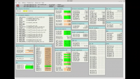
During the press briefing today, I just about fell out of my chair when they showed this example of one of the EDL status screens. Here's my best attempt at screenshotting it.
|
Posted by: djellison Nov 26 2018, 03:50 AM
https://www.nasa.gov/sites/default/files/thumbnails/image/pia22830-16.jpg
For those trying to figure out the geometry.......Martian north is basically 'down' in this image.
Posted by: nprev Nov 26 2018, 07:39 AM
TCM update:
"At 1:47 p.m. PST (4:47 p.m. EST) engineers successfully conducted a last trajectory correction maneuver to steer the spacecraft within a few kilometers of its targeted entry point over Mars. Engineers still need to conduct a last trajectory correction maneuver to steer the spacecraft toward its entry point over Mars. About two hours before hitting the atmosphere, the entry, descent and landing (EDL) team might also upload some final tweaks to the algorithm that guides the spacecraft safely to the surface."
https://mars.nasa.gov/news/8391/nasas-insight-is-one-day-away-from-mars/?site=insight
Posted by: propguy Nov 26 2018, 07:54 AM
"At 1:47 p.m. PST (4:47 p.m. EST) engineers successfully conducted a last trajectory correction maneuver to steer the spacecraft within a few kilometers of its targeted entry point over Mars. Engineers still need to conduct a last trajectory correction maneuver to steer the spacecraft toward its entry point over Mars. About two hours before hitting the atmosphere, the entry, descent and landing (EDL) team might also upload some final tweaks to the algorithm that guides the spacecraft safely to the surface."
https://mars.nasa.gov/news/8391/nasas-insight-is-one-day-away-from-mars/?site=insight
That is a somewhat confusing report on activities. We did perform TCM6 today and it was very successful. We do not have any more TCM's to perform (that is the somewhat confusing portion of the report). Latest Navigation report show us very close to the entry corridor and estimates of the ground landing ellipse shows over 99% chance of landing on the perfect terrain for InSight (think Bonneville Salts Flat). The last portion is accurate in that the EDL tream is reviewing atmosphere models and entry location to set the last set of parameters for entry. Prop system preheats of the portions of the system used for EDL only (pressurization system and descent components) are well underway and looking good. Just about E-12 hrs and we are ready for EDL! Going to be a great day tomorrow! Go InSight and Go Marco!
Posted by: ollopa Nov 26 2018, 08:09 AM
[i]"At 1:47 p.m. PST (4:47 p.m. EST) engineers successfully conducted a last trajectory correction maneuver to steer the spacecraft within a few kilometers of its targeted entry point over Mars. Engineers still need to conduct a last trajectory correction maneuver to steer the spacecraft toward its entry point over Mars.
https://mars.nasa.gov/news/8391/nasas-insight-is-one-day-away-from-mars/?site=insight
This seems very ambiguous. Does anyone have authoritative information that would clarify? Does the press release mean there is to be a TCM-6x at 12:42:27 UTC, or did they just forget to remove the reference to a "last trajectory correction" when they updated the post?
Also, can anyone remember if MPL and PHX used a TCM-6 or TCM-6x?
Posted by: nprev Nov 26 2018, 08:15 AM
Yeah, I don't know. Might be a bad edit on their part.
I don't really think that they have enough time left for another TCM because I'd assume that it'd take substantially more propellant to produce the same effect with every passing minute right now.
EDIT: Whups, missed Propguy's post above; much clearer. Thanks, man. Think it's all good, ollopa; no further TCMs, just entry parameter updates.
GO INSIGHT!!!
Posted by: propguy Nov 26 2018, 08:23 AM
Also, can anyone remember if MPL and PHX used a TCM-6 or TCM-6x?
See my post on the end of page 8. No additional TCM's will be conducted. PHX did not do a TCM6, but we only did it to ensure we were right on the center of the ellipse (all trajectory values pre-TCM6 met entry requirements, just being extra safe, which is a great idea). Got to get to bed to be ready for EDL. Hope you all enjoy the day tomorrow (actually later today). I am sure I will get my track record above 50/50 (MPL and PHX being my previous landing missions).
Posted by: dmuller Nov 26 2018, 08:26 AM
Yeah, propguy clarified in post #120. From what I've read, TCM-6X wouldnt have been more of a alternate or part 2 of TCM6 rather than clean up a TCM6 gone wrong.
Also, I see you quote "12:42:27 UTC" ... if you've taken that from my website, thanks for the visit, and a note that it was just my best guess based on descriptions I had ("so-and-so many hours before landing" which I took as "before EI" based on EI info I had at the time). I havent coded functionality yet for events that are not known (to me) to the second precise. If it was the actual time considered, that'd be spooky

Posted by: dmuller Nov 26 2018, 08:27 AM
What time is Entry Interface, SpaceCraft Event Time, to the second precise? Does anybody here know
Posted by: dmuller Nov 26 2018, 12:28 PM
I have MarCO closest approach numbers, inferred from what's in Horizons now:
MarCO-B 19:47:45 UTC SCET at 1,750km altitude
Posted by: climber Nov 26 2018, 02:34 PM
MarCO-B 19:47:45 UTC SCET at 1,750km altitude
Daniel, one important information is missing in your simulation timeline: Start eating Peanuts.
Posted by: nogal Nov 26 2018, 03:09 PM
It was already late (so I couldn't do an update) when I found in YouTube the https://www.youtube.com/watch?v=0tfyFRKa3Vk. At about 9:30 minutes into the video Tom Hoffman describes how the successive TCMs adjusted the landing ellipse ever closer to the intended target and shows (at about 10:25) the ellipse after TCM 5, which (center) was about 11 miles (ENE) away from the desired target location. So it was decided to perform another TCM, which has already been discussed in this thread.
For what it is worth, here is the InSight EDL file again (I have merged the two files from posts http://www.unmannedspaceflight.com/index.php?showtopic=8384&view=findpost&p=241918 and http://www.unmannedspaceflight.com/index.php?showtopic=8384&view=findpost&p=241930) including the target, the landing ellipse after TCM 5, and the EDL path now leading to the target.
Less than 5 hours now... GO, GO INSIGHT!
InSight_EDL_Sim.kmz ( 18.87K )
: 913
Posted by: nprev Nov 26 2018, 04:01 PM
Here we go! http://www.unmannedspaceflight.com/index.php?s=&showtopic=8430&view=findpost&p=241909, please move discussion over there. NASA TV coverage will begin in three hours (1900 GMT).
Posted by: Explorer1 Feb 5 2019, 07:49 PM
Not sure if there's a more appropriate thread: the MarCO's have fallen silent: https://www.jpl.nasa.gov/news/news.php?feature=7327
They might try to contact them again next perihelion, but not very likely. Congrats to the team on a unique (and very helpful) experiment!
Powered by Invision Power Board (http://www.invisionboard.com)
© Invision Power Services (http://www.invisionpower.com)