Dawn approaches Vesta, Approach phase, 3 May to 16 July 2011 |

  |
Dawn approaches Vesta, Approach phase, 3 May to 16 July 2011 |
 Jul 14 2011, 04:37 PM Jul 14 2011, 04:37 PM
Post
#406
|
||
|
Solar System Cartographer  Group: Members Posts: 10170 Joined: 5-April 05 From: Canada Member No.: 227 |
I have made a VERY crude attempt to combine the existing images into a cylindrical projection map, more to show approximate coverage than anything else. The previous (July 1st) image extended up into equatorial latitudes in the hemisphere opposite to the side seen in the new view.
Phil
-------------------- ... because the Solar System ain't gonna map itself.
Also to be found posting similar content on https://mastodon.social/@PhilStooke Maps for download (free PD: https://upload.wikimedia.org/wikipedia/comm...Cartography.pdf NOTE: everything created by me which I post on UMSF is considered to be in the public domain (NOT CC, public domain) |
|
 |
 
|
|
|
Jul 14 2011, 05:06 PM
Post
#407
|
|
|
Member Group: Members Posts: 220 Joined: 13-October 05 Member No.: 528 |
QUOTE (ElkGroveDan @ Jul 14 2011, 06:45 AM)  OK that was nice. How long before we get to Ceres? LOL. A while back I was looking at the best Hubble shot of Ceres and was thinking the same thing. But first we shall have to suffer through the detailed mapping and higher resolution images of Vesta before moving on. There are worse fates, I suppose. How long until the Pallas flyby? |
|
|
|
|
Jul 14 2011, 05:30 PM
Post
#408
|
|
 Member Group: Members Posts: 259 Joined: 23-January 05 From: Seattle, WA Member No.: 156 |
I'm wonder if, due to Vesta's low gravity, the ridge on the central peak is ejecta from the impact. Might some of it have sailed all the way around Vesta and landed back more or less where it started?
|
|
|
|
|
Jul 14 2011, 05:58 PM
Post
#409
|
|
|
Solar System Cartographer Group: Members Posts: 10170 Joined: 5-April 05 From: Canada Member No.: 227 |
That's pretty much what pjam suggested up above. I think a tectonic explanation looks better, especially now.
If the grooves are graben, a high-standing block between them would be a horst. So it might be called the Keller Horst to celebrate one of the most prominent Dawn team members. (just kidding!) Phil -------------------- ... because the Solar System ain't gonna map itself.
Also to be found posting similar content on https://mastodon.social/@PhilStooke Maps for download (free PD: https://upload.wikimedia.org/wikipedia/comm...Cartography.pdf NOTE: everything created by me which I post on UMSF is considered to be in the public domain (NOT CC, public domain) |
|
|
|
|
Jul 14 2011, 08:11 PM
Post
#410
|
||
 Senior Member Group: Members Posts: 2492 Joined: 15-January 05 From: center Italy Member No.: 150 |
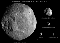
I processed the tiff image (thanks for highlight, Juramike!) and I used it to update the scale comparison:
This side do not show the dicothomy (smoothed vs rough) previously seen while the nature of disturbed terrain inside the super-south-crater is now clear... HEY! this picture was shoot during my birthday! 
-------------------- I always think before posting! - Marco -
|
|
|
|
|
|
|
Jul 15 2011, 02:06 AM
Post
#411
|
|
|
Member Group: Members Posts: 903 Joined: 30-January 05 Member No.: 162 |
How much bigger does that montage have to be to get Itokawa bigger than 1 pixel?
(  , just amazed at the scaling we now have good data on these interesting objects) , just amazed at the scaling we now have good data on these interesting objects)And we are all probably still antsy to see the antipode of the big ole peak! |
|
|
|
|
Jul 15 2011, 04:27 AM
Post
#412
|
|
|
Newbie Group: Members Posts: 13 Joined: 14-October 07 Member No.: 3937 |
Dilo that is well done, It will be nice when Ceres gets added to it!
|
|
|
|
|
Jul 15 2011, 05:32 AM
Post
#413
|
||
|
Newbie Group: Members Posts: 12 Joined: 2-September 08 From: Bad Gandersheim, Germany Member No.: 4327 |
QUOTE (dilo @ Jul 14 2011, 10:11 PM) I processed the tiff image (thanks for highlight, Juramike!) and I used it to update the scale comparison:
This side do not show the dicothomy (smoothed vs rough) previously seen while the nature of disturbed terrain inside the super-south-crater is now clear... HEY! this picture was shoot during my birthday! New winner for the Ops Room door 
|
|
|
|
|
|
|
Jul 15 2011, 07:46 AM
Post
#414
|
|
|
Member Group: Members Posts: 315 Joined: 1-October 06 Member No.: 1206 |
That central uplift sure looks like its made of different material. It almost looks diapir-like. Material squeezed/rebounded up from the deep mantle?
Also look at the size of that cliff/basin wall in the sunlight to the left on the picture. Thats gotta be kilometres high! (Miranda again). Wow. P |
|
|
|
|
Jul 15 2011, 08:19 AM
Post
#415
|
|
|
Member Group: Members Posts: 362 Joined: 13-April 06 From: Malta Member No.: 741 |
would the hump be a volcano and the surrounding grooves, lava flows?
|
|
|
|
|
Jul 15 2011, 08:30 AM
Post
#416
|
|
|
Member Group: Members Posts: 315 Joined: 1-October 06 Member No.: 1206 |
Hmmmm, cropping Dilo's image, all sorts of interesting things crop up. Crater chains, albedo differences etc. But this caught my eye.
 An odd, 'cartouche' like set of grabens? with what looks like a cinder cone? in the middle? Or just artefacts? And that arrowed crater with two sections of dark floor - shadows? lava flooded? This is going to get interesting.... P |
|
|
|
|
Jul 15 2011, 10:28 AM
Post
#417
|
||
|
Senior Member Group: Members Posts: 2492 Joined: 15-January 05 From: center Italy Member No.: 150 |
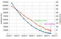
The following plots shows the progress of distance and relative velocity during the approach phase, based on mission status updates and, for the last points, on the simulator in the Dawn site (thanks to people who collected snapshot of it in this thread!):
On june 26, Dawn entered the Vesta gravitational sphere of influence (about 125000 km radius, green arrow); however, speed need to be reduced below parabolic-trajectory limit for gravitational capture and orbit insertion. Based on latest JPL press release, this will happen tomorrow around 5:00 UTC at 15900 km distance; this implies a relative speed between 33,5 and 47,5 m/s, adopting a mass of 2,67e20 kg for Vetsa. Even assuming an initially elliptic orbit (indicative insertion speed of 40m/s), current declared speed of 48 m/s implies an average deceleration of 1,3e-4 m/s2 which is probably too high unless they use chemical propulsion (ion motor deceleration never went above 6.6e-5 m/s2 during approach phase), so I tend to suspect actual speed is lower than declared in the simulator. A confirm of this suspect arises from last Mission Status which declares only 37 m/s on July,13; at 23000km, such a speed would garantee Dawn is already gravitationally captured, even though on a highly elliptic orbit! Do someone knows more details on incoming insertion maneuver? -------------------- I always think before posting! - Marco -
|
|
|
|
|
|
|
Jul 16 2011, 02:39 AM
Post
#418
|
|
 Member Group: Members Posts: 714 Joined: 3-January 08 Member No.: 3995 |
Just some early hypothesizing for my own entertainment....
I'm starting to wonder if the striations could be linear plutonic structures (i.e. a system of more-or-less parallel dikes) that were exposed after the giant impact blew away the overlying material. They seem to reside within the impact basin but not in the surrounding terrain. This may indicate that they represent some structures deep beneath the surface. Also, the younger and thinner regolith within the basin should preserve any surface expression of subsurface features better than in the surrounding landscape. These are also present on the central mountain, but to a lesser degree. Such features should be preserved within an impact rebound, I would think. Their appearance strike me as being albedo features -- at least to some extent. Could this represent different rock types (i.e. the origin of the Eucrite and Diogenite metorites)? Could these be relicts from the time of 'planetary' differentiation, when heavier and lighter materials separated from each other? Why are the features parallel? Who knows, but this would possibly give valuable insight into differentiation processes (and perhaps mantle processes within the earth). Oh, and any topographic relief along these features would be due to fault movement between the units. Thoughts? Again, I know it's early, but still.... ---------- A (simplified) cross-section of Vesta's interior and impact basin (not necessarily to scale): [attachment=24808:Vesta_interior_2.PNG] The arrows indicate the movement of magma during differentiation. |
|
|
|
|
Jul 16 2011, 03:39 AM
Post
#419
|
|
|
Senior Member Group: Members Posts: 1018 Joined: 29-November 05 From: Seattle, WA, USA Member No.: 590 |
QUOTE (dilo @ Jul 15 2011, 02:28 AM) The following plots shows the progress of distance and relative velocity during the approach phase, based on mission status updates and, for the last points, on the simulator in the Dawn site (thanks to people who collected snapshot of it in this thread!): Why are you so sure there's a strictly linear relationship between velocity and distance from Vesta? --Greg |
|
|
|
|
Jul 16 2011, 04:50 AM
Post
#420
|
|
 Member Group: Members Posts: 404 Joined: 5-January 10 Member No.: 5161 |
The kiwi hypotheses.
|
|
|
|
|

|
Lo-Fi Version | Time is now: 28th May 2024 - 02:29 PM |
|
RULES AND GUIDELINES Please read the Forum Rules and Guidelines before posting. IMAGE COPYRIGHT |
OPINIONS AND MODERATION Opinions expressed on UnmannedSpaceflight.com are those of the individual posters and do not necessarily reflect the opinions of UnmannedSpaceflight.com or The Planetary Society. The all-volunteer UnmannedSpaceflight.com moderation team is wholly independent of The Planetary Society. The Planetary Society has no influence over decisions made by the UnmannedSpaceflight.com moderators. |
SUPPORT THE FORUM Unmannedspaceflight.com is funded by the Planetary Society. Please consider supporting our work and many other projects by donating to the Society or becoming a member. |
|