Printable Version of Topic
Click here to view this topic in its original format
Unmanned Spaceflight.com _ Cassini PDS _ Dione Image Products
Posted by: Exploitcorporations Oct 15 2005, 10:19 AM
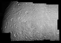
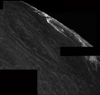
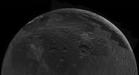
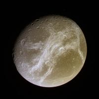
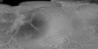
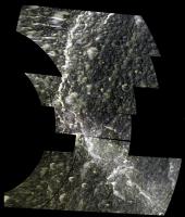
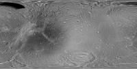
Padua Linea mosaic:
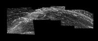
|
Posted by: Exploitcorporations Oct 15 2005, 11:11 AM
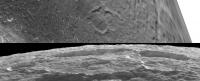
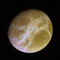
Just for fun:
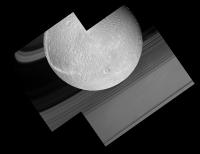
|
Posted by: SigurRosFan Oct 15 2005, 11:57 AM
No words, just great!!
Posted by: SigurRosFan Oct 15 2005, 12:13 PM
What is that straight line in the bottom part of the second mosaic ?
Posted by: Rob Pinnegar Oct 15 2005, 01:04 PM
Looks like the rings to me.
Posted by: SigurRosFan Oct 15 2005, 01:25 PM
But which ring?
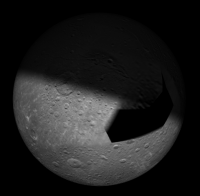
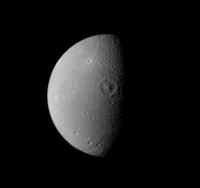
Posted by: Exploitcorporations Oct 15 2005, 01:31 PM
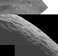
Crescent(no s--t, huh?):
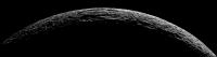
|
Posted by: dilo Oct 15 2005, 01:55 PM
Exploitcorporations, your mosaics are really impressive...  great job!
About SRFan question (which ring?), the answer is here:
http://saturn.jpl.nasa.gov/multimedia/images/raw/raw-images-details.cfm?feiImageID=51438
Posted by: Mariner9 Oct 15 2005, 03:12 PM
SiguRosFan - I think the "ring" you asked about is the Enke Division. So you are not seeing a ring, per se, but an absence of rings.
Posted by: Mariner9 Oct 15 2005, 03:20 PM
Oops..... or all of the rings as the case may be.
I suspect dilo is correct. Since the spacecraft was close to Dione when it took the pic, it would have been nearly in the plane of the rings. Therefore the "rings" we see at the top of the image are the shadow of the rings on Saturn's cloudtops, and the "ring" we see at the botton of the picture is actually all of saturn's rings edge on.
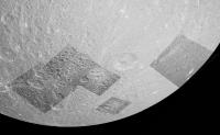
Posted by: Exploitcorporations Oct 15 2005, 10:26 PM
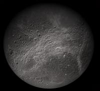
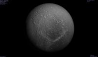
9-frame globe:
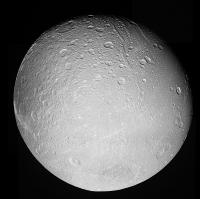
|
Posted by: um3k Oct 17 2005, 03:12 PM
|
|

You clipped all the shadow detail!

Posted by: Exploitcorporations Oct 18 2005, 12:22 AM
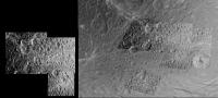
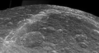
Regional map:
|
Posted by: Exploitcorporations Oct 21 2005, 01:40 AM
Trying to identify the locations of WAC and Saturnshine frames, as well as those last few NAC frames before the crescent mosaic. Maybe there's a better way to do this than visually? Any help would be appreciated.
Steve's map with WAC 00011127-00011130 & last frame of big regional mosaic:
|
Posted by: jmknapp Oct 26 2005, 07:54 PM
I'd think a way to approach it might be to use the SPICE kernels to get the instrument pointing as a function of time. It's possible to get the intersection of the camera boresight and the surface of the target (longitude, latitude) for any given time. That would give the lon/lat of the center of the image if the time that it was taken is known.
Unfortunately, the Cassini website doesn't give the time, just the date of each photo. But it does give the distance, so the spacecraft distance could be used as a proxy for the time. There would be some error, but it might give the location within a degree.
Posted by: Exploitcorporations Oct 27 2005, 06:23 PM
Unfortunately, the Cassini website doesn't give the time, just the date of each photo. But it does give the distance, so the spacecraft distance could be used as a proxy for the time. There would be some error, but it might give the location within a degree.
Thank you. I'm curious as to the exact process used by imaging scientists to construct the spectacular (and accurate) mosaics that are publicly released. As is certainly obvious, my own "handlaid" composites exhibit gross distortions and misalignments, particularly with global views(see the squashed-looking south pole of Dione above). I would imagine that the lat/lon centerpoints could be positioned on a spherical model and the individual images reprojected accordingly as they are placed.
Posted by: volcanopele Oct 27 2005, 06:40 PM
I use the SPICE kernels and information provided to us where we download the raws (similar interface to the PDS) to navigate each image in a program called ISIS (publically available from the USGS website). I refine those solutions using a combination of limb fits, tieing to a basemap, or tieing to adjacent images. once I am confident that the lat and lons in my images are accurate, I can use ISIS to reproject each image to the same geometry. For the Dione and Tethys mosaics released recently, those are orthographic projections centered on the same lat and lon and with the same pixel scale. For public release products, I just piece these together in Photoshop, just to speed things along. I can also mosaic the images in ISIS, but often that's a slower process.
Posted by: djellison Oct 27 2005, 07:34 PM
I must admit - doing mosaics with a combo of PTGui and Photoshop is a lot easier now Photoshop has the warp tool, very powerfull and usefull
Doug
Posted by: Exploitcorporations Oct 28 2005, 02:54 PM
Thanks for the fascinating primer. I must admit that my learning curve with image assembly has been a comedy of errors.
 I made my first composite in Photoshop last January(a crescent Iapetus), but only figured out how to use the transform feature shortly after the Tethys flyby( I stumbled upon the warp tool by using an unintended key combo). I spent roughly three years doing cut-and-paste Galileo mosaics with a printer and a stack of 14x17 "magnetic" photo albums. The only people who were remotely interested in this bizzare hobby were a couple of clerks at the local USGS map store, where I would occasionaly drag one of those ridiculouly massive albums for them to pore over. Photoshop is a little less messy...
Posted by: scalbers Oct 29 2005, 03:29 PM
Greetings,
I learned recently that there is a SPICE kernel interface for IDL on the naif.jpl.nasa.gov site. It could take me quite a while, yet this would be interesting to incorporate into my satellite mapping software. Then if I can set up a PDS/IMG interface I'd be all set...
BTW my latest Dione map update uses about as much of the released global (3x3) mosaic from the latest flyby as is reasonable. Now I can consider whether to include some of the regional imagery.
http://laps.fsl.noaa.gov/albers/sos/sos.html#DIONE
Posted by: Exploitcorporations Jan 11 2006, 08:41 AM
A few of the southern high-resolution frames(updated).
Background mosaic by NASA/JPL:
|
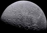
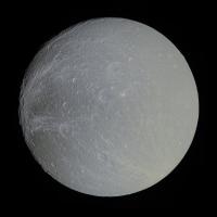
Posted by: dilo Mar 25 2006, 05:22 PM
Beautiful view of Dione at low phase angle, taken from 1425000 Km on 23MAR2006/20:02:18 UTC
(clear background should be E ring...)
|
Original images:
luma channel: N00055875.jpg (clear filter)
chroma components: R=N00055873 (MT2), G=N00055874 (G), B=N00055873 (UV)
Posted by: Exploitcorporations May 27 2006, 01:26 PM
Here's an update on the D1 encounter last October, looking at the context for crescent and Saturnshine observations following closest approach. Thanks to Steve Albers for your astonishing maps and Chris Laurel for Celestia.
Amata mosaic:
|
Broad context:
|
High resolution frames:
|
Crescent mosaic (apologies to um3k for first attempt):
|
Posted by: Exploitcorporations May 27 2006, 03:09 PM
Full context:
|
Posted by: um3k May 27 2006, 03:21 PM
Totally excellent, dude! 
Posted by: Exploitcorporations May 27 2006, 11:38 PM
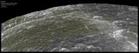
Just a heads-up for the rev after next...it looks as though Cassini will have an outstanding moderate-resolution view of pretty much the whole fracture system, as well as additional gap fill coverage to the north. This view of Dione on 24 July 2006 from Celestia's reference trajectory is from a distance of 260,000km, the field of view narrowed by a factor of two for visibility.
|
Posted by: angel1801 May 28 2006, 05:44 AM
Using the Solar System Simulator, I also have some good imaging opportunties for Dione:
November 20, 2006 (260,000km)
Good imaging of the moons south pole area as a crescent (like Iapetus on April 11, 2006!)
September 30, 2007 (78,000km)
The entire saturn facing hemisphere is sunlit!
Posted by: SigurRosFan May 29 2006, 01:59 PM
Some compositions ...
|
|
Posted by: belleraphon1 Jun 23 2006, 06:43 PM
Has anyone noted tthe CASSINI CHARM presentation from 06/29/06?
"Magnetic Portraits of the Icy Satellites of Saturn"
Slide 27 to 32 and slide 45 conclude there is mass-loading at Dione so there may also be plume activity from this moon as well as Enceladus. The Dione mass-loading is an order of magnitude less than the Enceladus mass loading but the the team feels sure this is a REAL event.
Very cool and maybe we should be looking for some very faint plumes at Dione.
Also interesting that Dione and Enceladus both appear to have the greater density of any of the mid sized moons.
Posted by: belleraphon1 Jun 23 2006, 06:47 PM
"Magnetic Portraits of the Icy Satellites of Saturn"
Slide 27 to 32 and slide 45 conclude there is mass-loading at Dione so there may also be plume activity from this moon as well as Enceladus. The Dione mass-loading is an order of magnitude less than the Enceladus mass loading but the the team feels sure this is a REAL event.
Very cool and maybe we should be looking for some very faint plumes at Dione.
Also interesting that Dione and Enceladus both appear to have the greater density of any of the mid sized moons.
Sorry all... the date on the presentation web site is 05/29/06...... I fumble fiingered ....
Also, these image mosaics are just awesome..... congrats to all.................

Posted by: belleraphon1 Jun 23 2006, 06:56 PM
All.... trying to do this from work and keep forgetting things I meant to add in the first note I posted...
Here is the presentation I was talking about ............
http://saturn.jpl.nasa.gov/multimedia/products/pdfs/20060527_CHARM_Krishan.pdf
Dione ....... a scent of water/nitrogen perfume still wafting the Saturnian system????
Posted by: Bart Jul 5 2006, 08:17 PM
Yeah, I pointed this out here http://www.unmannedspaceflight.com/index.php?s=&showtopic=1067&view=findpost&p=55911
I thought it was pretty cool too, but the response seemed to be deafening silence.
Bart
Posted by: tedstryk Jul 5 2006, 08:48 PM
Fantastic work. Might I suggest changing your name to Exploitphotomosaics ?
Posted by: edstrick Jul 6 2006, 09:54 AM
I did read that, but didn't get back to the thread...
"Curiouser and Curiouser, said Alice"
Dione has higher density than most of the small moons, doesn't it?.. more isotope heat..
It's the only moon other than the hot enchilada with relatively pristine fracture patterns.
It has flat areas largely lacking large impacts and they seem relatively textureless other than smaller impact crater populations... as though they'd been resurfaced.
Isn't Dione the sat in a resonance with Enceladas?
It'd be the only other candidate in the system for any internal heating driven outgassing, "fer sure". Tethys had activity and resurfacing but looks pretty thoroughally dead now.
Posted by: angel1801 Jul 25 2006, 08:44 AM
|
|
The Dione images were successfully taken and transmitted to earth and the 11 images are available as raw images. Also there are some good images of Rhea's south pole area in a crescent position from about 170,000 km out too.
Posted by: MarcF Jul 25 2006, 08:19 PM
After watching these pictures I'm still wondering about the reality of the Amata basin.
These pictures as well as most of the pictures of the same region taken with a lower resolution (Voyager 1 included) seem to show that it indeed exists. However, the high resolution pictures (which were all taken at low sun angle) do not show any trace of the basin. After the close flybys I was convinced about its non-existence, but now, I again have a doubt. So could it be a kind of palimpsest indicating a very old basin almost erased by the younger overlying tectonic patterns or is it just an optic illusion due to fortuitous placing of tectonic, impact and albedo features ?
Posted by: dilo Jul 25 2006, 11:11 PM
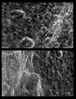
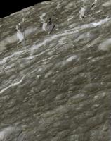
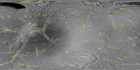
I made this pseudo color (MT2+CL+UV filters) of last Dione view and only now I noticed the stright, narrow, bright features in the right/bottom region. Some of them clearly originate from a common point (impact?)...
Can someone explain these "channels"?
|
|
Posted by: Michael Capobianco Jul 25 2006, 11:45 PM
They were originally thought to be crater rays and named Cassandra. Current theory says that they're a system of radial fractures and scarps.
Michael
Posted by: dilo Jul 26 2006, 05:57 AM
Thanks Michael; this is amazing and recall me Europa, even if here channels aren't curved...
Posted by: Ian R Jul 26 2006, 04:45 PM
Dilo,
Here's a couple of earlier Cassini pictures of Dione that show Cassandra to good effect:
http://saturn.jpl.nasa.gov/multimedia/images/raw/casJPGFullS13/N00037561.jpg
http://saturn.jpl.nasa.gov/multimedia/images/raw/casJPGFullS11/N00035168.jpg
And here's a PDF discussing the origin of the feature:
http://www.planetary.brown.edu/m42/m42_68.pdf
Cheers,
Ian.
Posted by: dilo Jul 26 2006, 05:46 PM
Wow, this "wispy material" could be a surficial deposit associated with (cryo)volcanic exhalations along cracks!
Thanks, Ian.
Posted by: dvandorn Jul 27 2006, 01:09 AM
Yeah, when you look at the lines in detail, it appears that there may have been upwelling along the thicker portions.
These do look more like cracks than rays, don't they? They are emplaced radially, and would seem to have been caused by some type of impact at the center of the radia. You'd think the surface would only do that if it were a fairly thin layer of ice floating on a liquid ocean, wouldn't you?
-the other Doug
Posted by: Phil Stooke Jul 27 2006, 01:01 PM
I might have looked instead at diapir effects - let's say Cassandra marks a diapir that stalled, just producing a few radial cracks, while the main fracture system was produced by a major diapir-induced uplift, lots of basically radial fractures in broad lanes, plus a bit of central subsidence as the process ended, producing Amata. I think an impact would be more obvious.
Phil
Posted by: MarcF Jul 27 2006, 04:53 PM
Is there any chance that Dione is still active ? I would not be so surprised.
I heard about rumors of plumes. Does anyone know more about that ?
Dione is for me the third most interesting moon of Saturn (after Titan and Enceladus of course), far more interesting than the curious but likely old and frozen Iapetus. The tectonic features appear to be really "fresh" (as it seems to be also the case for the giant basin near the south pole).
Posted by: belleraphon1 Jul 28 2006, 04:13 PM
Any one look at the current CASSINI RAWS.....
probably just my bad eye eight (or blurry glasses), but I think I see a hint of diffuse activity along Dione's
crescent in this image.........
http://saturn.jpl.nasa.gov/multimedia/images/raw/raw-images-details.cfm?feiImageID=80462
Again..... see my earlier post to this thread regarding the CHARM presentation. Mass loading at Dione
was detected and the team suggests looking for plume activity...... wonder if this set of images is an attempt to do just that?????
Craig
Posted by: MarcF Jul 28 2006, 04:53 PM
Thanks Graig. It was indeed in your earlier post regarding the CHARM presentation that I heard about the possibility of a dionean plume. But no other info about it anywhere else.
Concerning the crescent picture, I can also see a kind of "hazy feature" above the limb. But it's really difficult to conclude. Moreover, it's not apparent in the second picture (artefact or different viewing angle ?).
It would be so great to detect a current active Dione !!
Marc.
Posted by: ugordan Jul 28 2006, 05:05 PM
That's definitely looking like a scattered light artifact. It appears right below the thickest and brightest part of the crescent. These are probably just optical navigation images, the phase angle isn't all that favorable for a plume search.
Posted by: dilo Jul 28 2006, 08:23 PM
I have to agree with ugordan, following elaboration with negative/smoothed weak details show that there isn't any trace of extended plume "à la Enceladus".

|
Posted by: belleraphon1 Jul 28 2006, 10:27 PM
Thanks for the comments MarcF, ugordon, and dilo....
Have to "kinda" agree. Wondered if the other image was taken at a slightly different exposure setting.
The CHARM presentation says the mass loading at Dione is an order of magnitude below what is seen at Enceladus. So I picture that as, perhaps, diffuse shedding of internal gassy molecules. It may not show up as a distinct plume. It may be distributed along the fracture systems......
What was the geometry of the Dione 16 encounter? What longitudes did that cover at closest approach?
Craig
Posted by: dilo Aug 3 2006, 09:13 AM
Another couple of false color elaborations based on a sequence of increasing exposures, clear filter images:

|

|
First one associate an RGB channel to each image while in the second one I tried to highlight dimmest details.
To highlight the small difference between position angle of subsolar point and the faint glow, which seems slightly rotated toward left (the difference is about 20 deg, measured from Dione center).
Again, not enough to say if there is a weak plume or an artifact but seems interesting...
Posted by: JRehling Aug 3 2006, 03:07 PM
|
|
|
|
First one associate an RGB channel to each image while in the second one I tried to highlight dimmest details.
To highlight the small difference between position angle of subsolar point and the faint glow, which seems slightly rotated toward left (the difference is about 20 deg, measured from Dione center).
Again, not enough to say if there is a weak plume or an artifact but seems interesting...
Just as a skeptical hypothesis, I wonder if this cometlike halo could be due to the summation of light coming from Dione plus some generalized light leak placed to the right.
Posted by: Big_Gazza Aug 21 2006, 10:59 AM
Some nice Dione images from Rev 27:
crescent stitch
http://www.members.optusnet.com.au/ics_gs/pics/Dione_N00064755_mosaic.JPG
night side
http://www.members.optusnet.com.au/ics_gs/pics/Dione_N00064758_mod.JPG
Posted by: ugordan Aug 21 2006, 11:16 AM
That's probably about right. All Cassini images exhibit an ever-so-slight halo around bright objects. I don't know if it's an inherent "feature" of the narrow angle camera or residual haze traces or simply diffraction/PSF effects. Probably a bit of everything. In any case, if the Dionian hypothetical plumes are real and much weaker than Enceladean (as it's been suggested), about the only way to see them would be to occult the Sun so there's no illuminated crescent visible. No saturnshine would be a bonus, too. Even then, it's a question of the plumes themselves being in sunlight. That's a lot of geometry constraints.
AFAIK, this is not going to happen since Cassini already executed its dedicated Dione flyby and is left with only a couple of distant flybys in the primary mission. The chance of the geometry being such that Dione will occult the sun is miniscule. We're likely stuck with only hints of activity from the magnetometer readings.
Posted by: dilo Aug 21 2006, 03:05 PM
I agree about the weak, estended halo similar to a cometary coma: probaly it is an artifact due to sensor + spurious light diffusion.
I was talking about the inner, "blue" (referred to 2nd image) halo within 1 Dione radius, which appear elongated and not exactly allineated to the Sun illumination... but, yes, I still in doubt about real interpretation and, yes, probably the only way to know is through unprogrammed eclipse...
What about magnetometer readings?
Posted by: dilo Aug 22 2006, 02:21 PM
Also very last images of Dione limb are odd, with a glare not aligned with Sun direction...
http://saturn.jpl.nasa.gov/multimedia/images/raw/casJPGFullS23/N00064895.jpg
I do not have photo-elaboration instruments in order to betteer see weak details but the fact they are still taking lot of images like this is a clear hint that they search/suspect something on Dione volcanism, IMO 
Posted by: dilo Aug 22 2006, 02:37 PM
Perhaps I have to step back on my last post... more careful analysis of entire sequence showed that, probably, glare is simply due to higher albedo in the left portion, as clear from this lower exposure:
http://saturn.jpl.nasa.gov/multimedia/images/raw/casJPGFullS23/N00064886.jpg
anyway, they are still taking lot of images like this. 
Posted by: ugordan Aug 22 2006, 02:52 PM
Well, it's not like they can choose NOT to take very high phase images right now

Posted by: MarcF Aug 25 2006, 02:59 PM
Some new hints about a current Dione internal activity from the 38th annual division for planetary science meeting :
Oral session 72
abstract presentation 72.01, Gerald Schubert.
Interiors of Enceladus, Dione and Rhea
http://www.abstractsonline.com/viewer/viewAbstract.asp?CKey={4E797BB2-0CC2-48FA-B6B5-C89AA4762D5D}&MKey={66F0352A-30DC-4B9F-B0CC-E851495B78DC}&AKey={AAF9AABA-B0FF-4235-8AEC-74F22FC76386}&SKey={FF55957F-841A-470E-BD22-AB52D1F706C5}
Marc.
Posted by: scalbers Sep 7 2006, 06:22 PM
Thought I'd mention a Dione map update using one of the July, 2006 images (as suggested in another thread). The URL for my latest map is:
http://laps.noaa.gov/albers/sos/sos.html#DIONE
Posted by: MarcF Oct 23 2006, 02:03 PM
A little reminder of the Voyager 1 Dione flyby, a long time ago:
http://saturn.jpl.nasa.gov/multimedia/images/image-details.cfm?imageID=2333
Marc.
Posted by: Exploitcorporations Nov 22 2006, 10:52 PM
Golden oldies, in anticipation for the 21 November encounter...if there was one. Here's the 15 December 2004 high-res view, with a few enhancements thanks to Mr. Albers and Celestia:

|
Posted by: Exploitcorporations Nov 22 2006, 10:54 PM
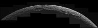
The Padua Linea mosaic in wide-angle context (11 October 2005):
|
Posted by: tasp Nov 23 2006, 03:20 AM
I reiterate my support for the term 'Enceledosian'.
It sounds more alienesque.

Posted by: dvandorn Nov 24 2006, 05:40 AM
I think I prefer "Enceladan"...
-the other Doug
Posted by: Exploitcorporations Feb 12 2007, 07:10 AM
I just came across these today, and don't remember having seen them at all before. They obviously seem to have been taken at the same time as the crescent mosaic. Just wanted to share:

|

|
Posted by: CAP-Team Apr 26 2007, 02:38 PM
I did a quick 'n dirty ir3/grn/uv3 combo to create a "color" image of the latest Dione flyby on april 24th, then I stitched them together.

|
Below is a simulated view of the same scene, using Steve Albers' map and xplanet.

|
Posted by: tedstryk Jun 4 2007, 05:57 PM
Here is a recent Dione mosaic compared to the Voyager high resolution mosaic. It is amazing how illumination effects crater visibility. The first link is to the full resolution version, the second link is to one without the lines showing the craters I am talking about.
http://www.strykfoto.org/outericymoons/dioniillumarked.jpg
http://www.strykfoto.org/outericymoons/dioniillu.jpg
Posted by: scalbers Jun 4 2007, 06:15 PM
Ted,
Yes I agree that illumination has an important effect on crater visibility. This area in particular was a consideration in prioritizing images for an updated Dione map version that I just posted on my website. I may want to tweak this some more, we'll see. The update is at this URL:
http://laps.noaa.gov/albers/sos/sos.html#DIONE
Posted by: tedstryk Jun 4 2007, 06:34 PM
It really is a troublesome area. By the way, here is the full resolution version of my Voyager mosaic, in case it is useful.
http://www.strykfoto.org/outericymoons/vdionef.png
Posted by: volcanopele Jun 6 2007, 06:29 PM
This mosaic has been officially released:
http://ciclops.org/view.php?id=3214
I have to say this is one my favorite views of Dione. A version of this image has been my desktop background for a while now.
Posted by: ugordan Jun 6 2007, 06:39 PM
While geometrically correct, I dislike the jaggedness at the limb these reprojections produce. It makes the mosaics look too artificial. I'd personally much prefer if the limb at these positions was slightly blurred/antialiased in Photoshop, the images are for public consumption and not scientific analysis anyway.
That said, this part of the release puzzles me:
Posted by: volcanopele Jun 6 2007, 06:46 PM
Yeah, that is an unfortunate side-effect. But I would rather that than not have the images align correctly. I stumbled on a solution when working on the until recently missing Tethys images, make my software think the radius of the satellite is bigger than it actually is. This caused my software to reproject the black background and Tethys, making the actual limb look at little more natural. Not my intended result, and if I were really working on Tethys maps, I might have complained a bit more.
Yeah, the image was a UV3/GRN/IR3 (or was it IR1..., grr, I can't remember) image, but rather than make it color ratio image (as has been done to similar false color images), it was made into a greyscale image.
Posted by: ugordan Jun 6 2007, 06:52 PM
Posted by: scalbers Jun 7 2007, 09:10 PM
http://www.strykfoto.org/outericymoons/vdionef.png
Yes this is a good one to add in - thanks much. You can see how it looks now on my updated map at this URL:
http://laps.noaa.gov/albers/sos/sos.html#DIONE
Posted by: Exploitcorporations Jun 9 2007, 05:34 AM
That is an outstanding version of the V1 Dione mosaic, Ted. The new map looks wonderful...that nasty seam between the Cassini and Voyager coverage has all but evaporated with the April imagery. It looks like there may be an opportunity to plug the remaining lower-resolution gap in September.

|
Posted by: scalbers Jun 10 2007, 04:28 PM
Thanks EC for the September preview - I'll keep an eye out for that. I also found your Dione poster to be inspirational and helpful in figuring out the image coverage from recent flybys. There are perhaps further clues lurking therein.
Posted by: tedstryk Jun 19 2007, 01:58 AM
Thanks! I had an earlier version of the Voyager mosaic I made, but I foolishly made it in 8-bit mode, and lost a lot of the benefit of stacking the images three-thick (I didn a super-resolution style processing, although I think the boosted SNR and more precise grayscale are the real improvements.
Posted by: MarcF Dec 20 2007, 04:07 PM
Dione images from December 19th are up: nice global view of the Odysseus-like basin:
http://saturn.jpl.nasa.gov/multimedia/images/raw/casJPGFullS36/N00098820.jpg
Marc.
Posted by: Ian R Dec 20 2007, 05:15 PM
Here's my IR-Green-UV composite:

|
Edit: changed the orientation so that the south pole is now at the bottom of the image.
Posted by: scalbers Dec 24 2007, 07:38 PM
I wonder where this alter-Odysseus has been hiding all this time. Perhaps it's the roughly depicted basin near 70S 210E on this map?
http://laps.noaa.gov/albers/sos/sos.html#DIONE
Posted by: ugordan Dec 24 2007, 08:04 PM
It wasn't hiding at all, it was seen back in 2005 when Cassini was still spending most of its time below the ringplane.
http://www.flickr.com/photos/ugordan/221191972/
Posted by: scalbers Dec 24 2007, 08:16 PM
Interesting Gordan, this is a good refresher for me on this basin. I'll have to consider adding the recent imagery to my map to see how much detail can be added. I've been using some raw imagery from the June 2005 flyby that you show above. Part of the basin rim appears to be overlain (and hidden) in the map by some low phase angle imagery (albeit at high resolution). Perhaps I can try to rework the image priorities to show a little more of the rim, particularly the northern portion. It looks like this was done in the http://photojournal.jpl.nasa.gov/jpeg/PIA08341.jpg. The Dec 2007 imagery looks like it will again benefit this northern rim area.
Taking a south-polar projection look at the map may be of interest in this assessment. Some features have the appearance of emanating from this basin.
(Edited 9:27PM UTC)
Posted by: ugordan Dec 24 2007, 08:31 PM
A tip on using Cassini images of gray targets like Dione for mapping purposes: the wisest choice would probably be the green filtered images ("CL1/GRN" for NAC and "GRN/CL2" for WAC), not clear filter, due to chromatic aberration issues. This especially goes for wide angle imagery. The point spread function is by far the tightest through that filter combo for WAC and to a lesser degree it's also the case for the narrow angle camera. The aberration is IIRC caused by field flattening optics (in the NAC at least, WAC is one big refractor anyway) and it was optimized for the visual wavelength range, centered at the green bandpass.
Posted by: scalbers Dec 24 2007, 09:46 PM
Thanks for the tip. I think I can see a slight improvement with the GRN filter on the Dec 2007 imagery, particularly near the limb.
Posted by: Exploitcorporations Dec 25 2007, 11:31 AM
This explains the apparent fuzziness of the basin in your maps, Steve...I always wondered why it wasn't more clearly defined. This feature is pretty subdued, but noticeable in Cassini pics as far back as May 2005. If I remember correctly, Phil identified this basin from Voyager imagery years ago. There are excellent high-resolution views at low phase angles obtained during the October 2005 encounter as well. It just seems to disappear from certain perspectives because the relief is so low. Dr. Stooke also stated here that features radial to basins like this are likely ejecta patterns rather than fractures (the "cat scratch" troughs near "Joan" on Iapetus are almost certainly of the same stripe IMHO). The Saturnian system seems like a remarkably good place to inventory large impact structures and related landforms across a broad range of ages and scales ("Claude" looks fresh enough to lick the frosting off of, and "S. Tirawa" looks old enough to make a Trilobite feel youthful).
Posted by: Bill Harris Dec 25 2007, 01:25 PM
LOL, I like that. The Saturnian system seems to be a encyclopedia of Things That Go WHUMP. It seems to have taken the LHB and improvised a few bars...
--Bill
Posted by: nprev Dec 25 2007, 03:31 PM
Yeah, I get that impression, too. Maybe the rings are all that's left of a WAY bigger cloud o' rocks that beat the moons until their morale improved a few billion years back. (Must've worked; you don't hear them complaining now... )
Posted by: scalbers Dec 28 2007, 12:39 AM
Here is a Celestia view of my current map, centered on the basin of interest. It looks extra large from the close perspective:

|
I think the Oct 2005 high resolution imagery is being used just in the northern (upper right) section at present. It is a bit tricky (as mentioned in post #82) since this is a low contrast region of that mosaic. Hopefully I can still make some improvements though.
Some of those features streaming off to the lower left may be only quasi-radial?
Steve (younger than a trilobite)
Posted by: MarcF Dec 28 2007, 12:08 PM
I like this view. With the December 19th pictures, I'm sure you will be able to make some improvements, Steeve.
The whole rim and internal structures are for the first time clearly visible, with a lot of details.
Marc.
Posted by: Decepticon Jan 5 2008, 01:02 AM
New images are up. http://saturn1.jpl.nasa.gov/multimedia/images/raw/raw-images-list.cfm?browseLatest=0&cacheQ=0&storedQ=0
Posted by: CAP-Team Jan 5 2008, 12:08 PM
I hope more images will follow, since this flyby greatly improves our map of the north pole of Dione.
|
Posted by: jasedm Jan 5 2008, 07:33 PM
Unfortunately I think that may be all there is on this flyby - the pointing seems to be a little off, as some frames duplicate coverage of craters Dido, Romulus and Remus (towards the 'western' limb), using the same suite of filters in each case.
Hope I'm wrong though..
Jase
Posted by: scalbers Jan 5 2008, 08:26 PM
Just in case, perhaps there's another opportunity to show this region on Feb 8th?

|
Posted by: scalbers Jan 11 2008, 06:52 PM
Greetings,
I've made a few updates to the Dione map, the latest being from 1/11/2008. There were a few additional images from the recent encounter after all, and one of them from January 3rd helps fill in the dione incognita near the north pole.
This version also has a reworking of the image priorities (plus the addition of a Dec 19th image) in the region of the southern basin we've been discussing. Hopefully some of it is more easily visible now. There is still a bit of a tradeoff between resolution, phase angle, and solar elevation for the northern rim. Here is a southern Celestia view...

|
The updated version of the 4K global cylindrical map is at the URL shown below:

|
http://laps.noaa.gov/albers/sos/sos.html#DIONE
That's the latest (edited 1/12),
Steve
Posted by: ugordan Jan 11 2008, 07:46 PM
There's a somewhat interesting spot visible in this recent raw imagery. It's bright in UV and is incospicuous in GRN and IR imagery. It's not an artifact of raw images, it's visible in polarized UV as well and it moves in the FOV following Dione so it's not a cosmic ray hit or flatfield effect. This UV-only-bright property sets it apart from many other UV bright features like fresh crater walls and other brighter splotches. I've located the spot in older imagery from the PDS as well, confirming it's a real feature:
http://i108.photobucket.com/albums/n15/ugordan/uv_bright.gif
Does anyone have an idea what kind of process would produce such a feature in the ice? My first thoughts are that it must be a very fresh impact crater. It's detectable in Ian Regan's composite in post http://www.unmannedspaceflight.com/index.php?s=&showtopic=1540&view=findpost&p=106010 as a bluish spot in otherwise yellow terrain in his composite.
Posted by: ugordan Mar 23 2008, 01:01 PM
Dione, Rev62:

|
Rough merge of green filter sunlit image and clear filter saturnshine image.
Posted by: tedstryk Mar 23 2008, 01:25 PM
I can't wait to see that made from real raw data!
Posted by: scalbers Mar 23 2008, 02:04 PM
I ran the flyby in Celestia and I see this is showing us more of the unknown northern terrain. Cassini has been approaching even closer this morning, so perhaps we'll see some higher resolution imagery coming up? On the other hand, the "Looking Ahead" section on the CICLOPS page mentions just the above observations at 665000km range on March 22.
Posted by: tedstryk Mar 23 2008, 04:54 PM
Voyager 2 got a pretty good view of this area.
|
Posted by: scalbers Mar 23 2008, 05:43 PM
Here is a possible Cassini view from 0600UTC today, that would add more to the map it seems. The sunlight would be on the opposite side of the north pole compared with the lower res Cassini view shown in post #96. I think the Voyager view above is reflected in my current map (3/13/2008 version).
So overall this flyby covers many longitudes around the north pole, if there is sufficient imagery being planned. As per the Celestia depiction, Dione could potentially be filling the NAC field of view around closest approach.

|
Posted by: Decepticon Mar 23 2008, 05:44 PM
I don't expect more images, why image Dione when hundreds of ring images need to be taken.
Posted by: tedstryk Mar 25 2008, 10:04 PM
Steve,
There is now a good opnav that shows the "hole" region - http://saturn.jpl.nasa.gov/multimedia/images/raw/raw-images-details.cfm?feiImageID=146810
There is a also a lone wide angle frame from the 23rd, which is odd. Makes me wonder if there are more Dione shots waiting to be transmitted.
Posted by: elakdawalla Mar 25 2008, 10:25 PM
Dione is slightly off center -- I'll bet you your lone wide angle shot is a context shot for a CIRS observation. A reminder of the various boresights:
--Emily
Posted by: john_s Mar 26 2008, 01:12 AM
That diagram looks pretty accurate except for the CIRS fields of view, which in reality are offset in the direction of the round "FP1" detector- FP1 is just outside the ISS NAC field of view and the other two detectors, FP3 and FP4, are both on the right-hand side of the NAC field of view.
John.
Posted by: Decepticon May 21 2008, 05:10 PM
A update Dione Map http://saturn.jpl.nasa.gov/multimedia/images/image-details.cfm?imageID=3079
Posted by: jasedm May 21 2008, 05:39 PM
Very noticeable that the feature previously known as Cassandra (~245deg West 42 deg South) doesn't show up too well on the new map. It was exceptionally prominent in distant Voyager images because of the albedo differential (and was assumed to be a ray crater)
The name Cassandra has now been used for a nearby crater by the IAU as the 'rays' with Cassini's better vision appear to be a series of tectonic features radiating from a central source.
Great to be party to the mapping of new worlds
Posted by: tedstryk May 22 2008, 02:23 PM
This is some very interesting work. The first, third, and fifth pages are the most interesting:
http://www.dlr.de/en/desktopdefault.aspx/tabid-1/86_read-12542/gallery-1/51_read-1/
http://www.dlr.de/en/desktopdefault.aspx/tabid-1/86_read-12542/gallery-1/51_read-2/
http://www.dlr.de/en/desktopdefault.aspx/tabid-1/86_read-12542/gallery-1/51_read-3/
http://www.dlr.de/en/desktopdefault.aspx/tabid-1/86_read-12542/gallery-1/51_read-4/
http://www.dlr.de/en/desktopdefault.aspx/tabid-1/86_read-12542/gallery-1/51_read-5/
Posted by: ugordan Mar 19 2009, 08:23 PM
I've recently been playing around with the September 30th 2007 flyby PDS data. Here's the inbound 2-frame mosaic, IR1/GRN/UV3 stretched, low-res color overlaid on full frame clear images:
http://www.flickr.com/photos/ugordan/3368850518/
Here's one of the highest resolution footprints in enhanced (boosted saturation and UV channel) IR1/GRN/UV3 color, taken from 47 000 km:
http://www.flickr.com/photos/ugordan/3368708936/
Notice the small, yellowish craters. There's material for a high resolution color mosaic, but there might be several data dropouts. I didn't even attempt it due to substantial viewing geometry change. I did do the outbound global mosaic, 7 NAC frames also in IR1/GRN/UV3 color, about 90 000 km distance:
http://www.flickr.com/photos/ugordan/2811548770/
Lastly, here's a quick-n-dirty enhancement of the splat subtly visible in even more distant imagery:

|
Posted by: jasedm Mar 19 2009, 08:31 PM
Fabulous work! - I particularly like the crescent view.
Posted by: tedstryk Mar 19 2009, 09:09 PM
|
|
Wow, that crater left quite a splat! Great work, Ugordan!
Posted by: ugordan Mar 19 2009, 10:05 PM
Here's the raw image merge from http://www.unmannedspaceflight.com/index.php?s=&showtopic=1540&view=findpost&p=111197 using calibrated data for comparison:

|
Posted by: tedstryk Mar 19 2009, 11:38 PM
By "raw" do you mean true raw images or the "raw" jpegs?
Posted by: dvandorn Mar 20 2009, 12:23 AM
Seconded! That splat is quite remarkable. Makes you wonder whether a darker, redder body impacted Dione, or an impactor exhumed a darker, redder layer out from under the bland icy crust.
Doesn't look like a deeper or fresher crater than others which left no splat, so I'm leaning towards the former.
-the other Doug
Posted by: Phil Stooke Mar 20 2009, 12:37 AM
No, that's not the real color.
Phil
Posted by: ugordan Mar 20 2009, 08:37 AM
I was referring to the raw (as in JPEG) merge from that post, only done with PDS data this time.
Posted by: ugordan Mar 20 2009, 08:41 AM
Phil is right, that's not the actual color, it's an enhancement to show the outlines of the splat. The ejecta blanket is subtly yellowish in stretched colors - similar to the high res shot showing a small crater inside. In natural color it's effectively unnoticeable.
Posted by: Decepticon Mar 23 2009, 03:20 PM
Amazing work.
Posted by: scalbers Jul 3 2009, 05:58 PM
Anything coming up for the non-targeted flyby on July 11? Looks about 87000km distance on dmuller's Cassini timeline.
Posted by: jasedm Jul 3 2009, 06:28 PM
Hi Steve,
Having checked out the Ciclops 'looking ahead' article for the next revolution, it appears there are no plans to image Dione on this pass. A shame, as I think some N. polar territory which has been poorly imaged hitherto would have been in view at Voyager-class distances (see SSS simulation below).
Obviously equinox studies are rightly taking precedence for the next month or so at or around periapse.
Dione will have a handful of very good passes in the XXM (if approved) so that's yet another thing to look forward to on this mission.
Jase

|
Posted by: jasedm Jul 15 2009, 01:04 PM
I spoke too soon, and reckoned without the ingenuity of the image-sequencing people....
They nabbed an opnav-range image of Dione which reveals some more detail in the N. polar region.
Range 427,997 taken on 11th July, slightly enhanced and cropped and rotated to match the solar system simulator view alongside.

|

|
Posted by: scalbers Jul 25 2009, 06:47 PM
Jase,
Thanks for the heads up, the new image indeed fills in northern areas in my map:
http://laps.noaa.gov/albers/sos/sos.html#DIONE
|
Kind of neat with the solar declination close to zero now and going towards positive.
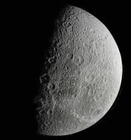
Steve
Posted by: ugordan May 9 2010, 03:12 PM
Here's a revisited Dione crescent mosaic from October 11, 2005. Official release is http://www.ciclops.org/view.php?id=1584. Due to the substantial amount of saturnshine present (remember, the flyby was low phase inbound with Saturn as backdrop so practically a "full" Saturn illuminates Dione's nightside here), there's a lot of detail present on the nightside, but it's lost in the official version.
http://farm5.static.flickr.com/4070/4588483985_e415037027_o.jpg
Sunstruck WAC frame for context:
http://i108.photobucket.com/albums/n15/ugordan/dione_20051011_wac_context.jpg
Posted by: jasedm May 9 2010, 09:02 PM
Magnificent Gordan.
Your version of the hi-res crescent shows unequivocally how icy the surface actually is, rather than being composed mostly of silicates.
It's easy to forget that these moons, were they orbiting closer to the sun, would have surfaces covered with water oceans.
Posted by: antipode May 9 2010, 10:13 PM
Wow!  Not only that, but look at that looooong slump face near the terminator - there are two large craters that have been so neatly sectioned in half they look like illustrations out of a book!
P
Posted by: Hungry4info May 9 2010, 11:05 PM
Wouldn't the water just boil instead of becoming liquid? The idea of a liquid ocean on these moons implies an atmospheric pressure suitable to allow water to exist in a liquid phase.
If Dione were near the sun, I would expect it to resemble a giant comet instead.
Posted by: jasedm May 10 2010, 07:51 PM
Yes, I'm sure you're correct H4I - I neglected to account for the atmospheric pressure....
Posted by: Explorer1 May 11 2010, 01:35 AM
It would have to be large enough to have enough gravity to hold on to an atmosphere. Other than Titan (rather obviously) only Ganymede has enough mass to hold on to one, correct?
Posted by: volcanopele May 11 2010, 01:51 AM
Yes and no. Keep in mind that surface temperature plays a role. In general, the higher the temperature, the faster the molecular speed. At Ganymede, that speed is faster than the escape velocity. At Titan, it isn't.
Posted by: DrShank May 11 2010, 01:49 PM
That splat is also visible in my color ratio maps and in stephans recent dione paper. Creusus is the name i think. nice to see the global view too!
Posted by: JohnVV May 13 2010, 06:15 AM
that is a good "splat" all right
a few views from a mesh in blender
[attachment=21615:Screenshot_4.png][attachment=21614:Screenshot_3.png] [attachment=21616:Screenshot_5.png][attachment=21617:Screenshot_6.png] [attachment=21618:Screenshot_7.png]
and a bump map - dem
[attachment=21619:di.png]
Posted by: Hungry4info May 13 2010, 11:07 AM
All four Galilean moons have tenuous atmospheres. Triton and Luna as well.
All of them except Triton, if I recall correctly, are constantly replenished (else they would quickly leave).
Posted by: volcanopele May 13 2010, 07:02 PM
Creusa. The flyby during Rev129 also provided some great views of that crater as well.
Posted by: machi Aug 10 2010, 07:20 AM
My first hi-res Dione (at 72 m/pix).
Filters IR3+GRN+UV3.
|
Posted by: ugordan Aug 10 2010, 07:35 AM
Heh, you have a good eye! I picked that exactly the same footprint to http://www.flickr.com/photos/ugordan/4589463582/ a while ago. Never did get the willpower to do the whole globe, but the lighting in this one seemed the best. Looks like I managed to upload a mirror image somehow - if it weren't for you I'd never figure it out 
Posted by: machi Aug 10 2010, 07:52 AM
So this is funny
I controlled all your images, which I downloaded to my computer and I thought, that you haven't this.
Another interesting thing - We both used same image orientation!
Posted by: JohnVV Aug 10 2010, 08:11 AM
with IR and UV the color can " be fun" to get near right
on average i use this formula -- give or take some--
------ Red ------------Green -----------Blue
(IR+ "20% green") ,( green) , (UV + " 20% green" )
10 to 30 % depending on just how FAR the IR and UV are away from the Visible
most of the time this works well
Posted by: machi Aug 11 2010, 06:45 PM
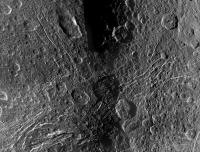
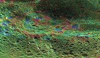
Padua Linea mosaic. Images from NAC camera overlaid over WAC frame (respective part of it).
Color from IR3, GRN and UV3 filters.
Images were calibrated by IMG2PNG (thanks Bjorn!) and warped by unwarpJ plugin in ImageJ.
|
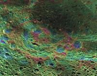
Posted by: DrShank Aug 12 2010, 12:44 AM
Padua Linea registered and reprojected (and subsampled)!
|
Posted by: CAP-Team Sep 5 2010, 10:17 PM
Looks like the most recent flyby adds a bit to Steve Albert's Dione Map!
|
Posted by: scalbers Sep 19 2010, 08:36 PM
Yes looks like some northern areas in particular were in view. Do any of the raw images show this well?
Posted by: Exploitcorporations Oct 5 2010, 07:25 AM
The September 3rd encounter really had some jaw-droppy stuff! Here's the monster mosaic, with 22 clear-filter footprints using one of the WAC frames for control. Steve, this one is unusually precise for me so parts of it might be useful for your map, at least until the professionals release the definitive version:
|
Posted by: Exploitcorporations Oct 5 2010, 07:31 AM
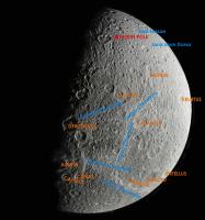
Color and annotated versions with north at the top. The location of the pole is a guesstumentation, as it was Terra Incognito until a few weeks ago. I'm sure someone can correct it.
|
|
Posted by: Exploitcorporations Oct 5 2010, 07:39 AM
ISS managed to cram in some amazing Saturnshine coverage complementary to the mosaic, and by complementary I mean an awesome Rorschach-blot split right down the terminator. The crater in the middle is Dercennus, with the Clusium Fossae to the northwest and Eurotas Chasmata to the northeast.
|
Posted by: Exploitcorporations Oct 5 2010, 09:12 AM
Wild speculation,...I'm convinced that the area surrounding Amata is a large, badly degraded palimpsest. The name Amata was of course reassigned to a crater because the feature that had that name pre-Cassini proved to be imaginary due to low resolution. There does seem to be a big, obvious circular feature there in low sun, but since I have a habit of imagining circular features, I will just leave this vaguely misleading, conspiracy-theorist-looking graphic and shuffle away whistling....
That's Neith in the middle of the bottom row:
|
Posted by: tedstryk Oct 5 2010, 01:29 PM
AMAZING! 
You should really change your username to "exploitimagery"
Posted by: Ian R Oct 5 2010, 02:39 PM
I agree Ted!
Posted by: DrShank Oct 5 2010, 03:58 PM
indeed, i presented my poster yesterday at DPS that showed this very same basin in my global topographic map of Dione. (I think i also showed it at the London meeting in 2008). it is about 350 km across and very visible as an asymmetric topographic ring with an offset central mound. the floor is relaxed, tho the rim and mound are about 2-3 km high.
(ps. preparing a blog on this and the other moons for later today . . . or tmrw!)
|
Posted by: jasedm Oct 5 2010, 10:02 PM
Oh that's simply gorgeous. Jaw-droppy indeed. Thanks for sharing.
Posted by: Explorer1 Oct 6 2010, 02:13 AM
Wow, thanks for the new desktop! It never ceases to amaze me what talent exists out here....
Posted by: nprev Oct 6 2010, 02:25 AM
EC strikes again!!! Great stuff, always; thank you!
Posted by: eoincampbell Oct 6 2010, 03:34 AM
Thanks for those wonderful images EC. Desk-topped!
Posted by: machi Oct 6 2010, 12:30 PM
Excellent mosaic!
Posted by: DrShank Oct 6 2010, 04:59 PM
I tried a perspective view of this ancient basin (which i tried to get named Amata by the IAU but they decided to use the name for a itty bitty crater). Here they are. they are not all that pretty but perhaps will help everyone visuallize its shape.
what is really cool about this structure is the way that the younger grabens make a right angle curve right in the floor of this basin, as if following the rim
|
|
Posted by: volcanopele Oct 6 2010, 05:13 PM
I'm guessing the odd shape and off-center central bulge of "The impact basin formerly known as Amata" is the result of extension on its west side, given all the graben on the west side.
At least that's how it is making sense in my mind.
Posted by: hendric Oct 7 2010, 01:46 PM
EC,
Great work! Makes a great background for a large display.
Posted by: stevesliva Oct 8 2010, 06:28 AM
You've scooped yourself:
http://saturn.jpl.nasa.gov/news/newsreleases/newsrelease20101007/
Posted by: scalbers Oct 10 2010, 03:34 PM
[attachment=22683:Dione_20100903.jpg]
Very nice mosaic EC - thanks for the suggestion about mapping. It's fun to dust off the Dione map and see how this fits in and adds new territory. So far so good. I'm posting here a grid overlay on your image. Looks like your north pole is fairly close to what I have at this point.
|
Posted by: scalbers Oct 10 2010, 05:27 PM
And here it is added onto a test version of the map...
|
I'm also working on refining a version that includes the Saturnshine images.
Posted by: scalbers Oct 23 2010, 03:49 PM
Here's a new version I processed this week:
|
And a full 8K resolution version (link below) that retains much of the detail in the images being used:
http://laps.noaa.gov/albers/sos/sos.html#DIONE
That's the latest,
Steve
Posted by: kyokugaisha May 28 2011, 09:46 PM
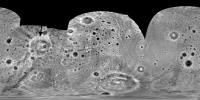
Apologies if someone has already posted something like this somewhere but here is a full, uncompressed montage of Dione using the recent PDS data from COISS 2062 (1649316409 to 1649319522). I believe the level of detail is about 250m/pix.
Its my first proper attempt at doing a montage. The only issue was with colouring as the IR1, GRN & UV3 filters give everything a yellowy tinge. So I'm not sure how accurate my amended colouring is.
The download is the full 9MB file
https://picasaweb.google.com/lh/photo/TZoh4hy_5w5m5nflc2EQ929Ah74aZ5n9sjAgH2UYRNQ?feat=directlink
and this is a very low res version.
|
Posted by: Hungry4info May 28 2011, 10:56 PM
Very nice!
Posted by: machi May 29 2011, 02:24 AM
Very nice and majestic mosaic!
If you want compare colors in your mosaic with real colors, you can compare images from ISS camera with VIMS cubes.
Gordan Ugarkovic (Ugordan) has very nice program http://www.unmannedspaceflight.com/index.php?act=attach&type=post&id=22060, which converts cubes to real color images.
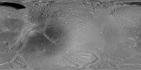
Posted by: scalbers Feb 27 2012, 12:18 AM
Greetings,
Here is a Dione map version with the feature names added to help in getting to know the place:
|
Full Resolution: http://laps.noaa.gov/albers/sos/features/combined_dione_lon_180_center.png
Steve
Posted by: Hungry4info Feb 27 2012, 03:05 AM
The Full resolution link doesn't work for me.
Posted by: scalbers Feb 27 2012, 04:57 PM
Ooops - I fixed this now. Hope it will satisfy your appetite
Posted by: machi Nov 25 2013, 06:17 PM
Finally, after long pause, I did some mosaic.
It's Dione (and rings) from images which Cassini took on 12.12.2011.
Mosaic contains high resolution data from 14 images and color from another 42 (filters UV3, GRN, and IR1).
Colors are set to approximately natural look.
Original high resolution images had resolution 349 - 476 m/pix and final mosaic has 300 m/pix resolution.
http://www.flickr.com/photos/109586958@N03/11015428253/
Posted by: Bjorn Jonsson Nov 28 2013, 11:31 PM
Great mosaic and one of the best ones of Dione I have seen. The Cassini ISS data set contains a huge amount of interesting stuff - it should be easy to find source data to make thousands of spectacular mosaics if time permitted.
Posted by: machi Nov 29 2013, 11:56 AM
Thanks! BTW, such mosaics are relatively easy to assemble thanks to your IMG2PNG calibration routine. So I thank you!
I looked at Cassini's data and for moons we can assemble a few dozens of larger mosaics (3×3 individual frames or more).
Little problem is, that several image processors are doing such mosaics and it's probably good idea not to duplicate works of others.
So every time before assembly of mosaic I'm doing little research who did what.
Posted by: elakdawalla Nov 29 2013, 05:37 PM
If you find nice large mosaics that are not in my image library already, please tell me (or just post links here)! I will include them and hopefully that will help you not duplicate others' work. I have your lovely Dione mosaic queued for posting but there has been so much good stuff to post lately that it's still in reserve.
Posted by: kyokugaisha Nov 29 2013, 05:56 PM
I used the same data for a greyscale montage a while back http://www.flickr.com/photos/76658917@N04/8236569838/. Your processing is much better though and you've taken the time to add the colour as well which I just ran out of patience with.
I'm interested to know why you didn't add in the other moons which were part of the data.
In regards to people producing images with the same data as others, I can't see a problem. I find it interesting and exiting to see other interpretations
Posted by: machi Nov 29 2013, 08:14 PM
I'll try to do some list.
I've used data from the same flyby but they are not the same data as yours.
Three reasons. 1. Data with moons have lower resolution. 2. Data with moons are BW only. 3. I saw BW Emily's mosaic with moons on the Planetary Society blog.
Making bigger mosaic is time consuming. I'm doing mosaics only when I can do such mosaic with some "added value" and highest added value is when mosaic
is entirely new.
Posted by: elakdawalla Nov 29 2013, 08:57 PM
I agree with both kyokugaisha and machi on this discussion. As a curator, I like seeing multiple (good) versions of image products, because it helps me to demonstrate how subjective choices are made during processing, and those choices differ from person to person. Of course, I also like seeing unique, new products, because there is so much underappreciated data in the archives. Both are valued!
Posted by: jccwrt Apr 7 2019, 04:18 PM
Here is my take on a crescent Dione taken on approach to the Rev 16 flyby (October 11, 2005). It uses a high-resolution NAC mosaic along the daylit limb of Dione, and then fills the remainder with a WAC image where Dione's night side is backlit by Saturnshine.
https://flic.kr/p/2ehhAZs
https://flic.kr/p/2ehhAZs
I also found a nice three-frame black and white mosaic from Rev 27 (August 18, 2006) looking over Dione's south pole. The Saturn-facing side of the trailing hemisphere is nicely backlit here as well.
https://flic.kr/p/24LFaJT
https://flic.kr/p/24LFaJT
Powered by Invision Power Board (http://www.invisionboard.com)
© Invision Power Services (http://www.invisionpower.com)