Mercury Flyby 2 |

  |
Mercury Flyby 2 |
 Oct 13 2008, 03:14 PM Oct 13 2008, 03:14 PM
Post
#116
|
|
 Interplanetary Dumpster Diver  Group: Admin Posts: 4404 Joined: 17-February 04 From: Powell, TN Member No.: 33 |
QUOTE (Phil Stooke @ Oct 12 2008, 04:00 AM)  We have very limited coverage of Triton, not many craters, and an unknown effect from regional variations in geology (Canteloup terrain vs the plains units elsewhere) - it's not a very robust analysis. Phil I have found the analysis to be relatively good, at least given the coverage we have. However, with Triton being in a retrograde orbit, the reason for the asymmetry may have nothing to do with the reason for the asymmetry on Mercury. -------------------- |
 |
 
|
|
Oct 13 2008, 04:06 PM
Post
#117
|
|
|
Solar System Cartographer Group: Members Posts: 10227 Joined: 5-April 05 From: Canada Member No.: 227 |
The limited coverage and poorly understood geology are the keys. If the crater retention age on canteloup terrain is different from that on the plains on the other side of the disk - or even if our ability to identify small craters varies between the two areas - the whole analysis is out the window.
Phil -------------------- ... because the Solar System ain't gonna map itself.
Also to be found posting similar content on https://mastodon.social/@PhilStooke Maps for download (free PDF: https://upload.wikimedia.org/wikipedia/comm...Cartography.pdf NOTE: everything created by me which I post on UMSF is considered to be in the public domain (NOT CC, public domain) |
|
|
|
|
Oct 14 2008, 08:06 PM
Post
#118
|
||
|
Solar System Cartographer Group: Members Posts: 10227 Joined: 5-April 05 From: Canada Member No.: 227 |
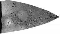
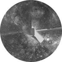
Back to Mercury! Some new images released today, including a limb view which I have rectified here.
Phil
-------------------- ... because the Solar System ain't gonna map itself.
Also to be found posting similar content on https://mastodon.social/@PhilStooke Maps for download (free PDF: https://upload.wikimedia.org/wikipedia/comm...Cartography.pdf NOTE: everything created by me which I post on UMSF is considered to be in the public domain (NOT CC, public domain) |
|
|
|
|
|
|
Oct 17 2008, 02:07 PM
Post
#119
|
||
|
Solar System Cartographer Group: Members Posts: 10227 Joined: 5-April 05 From: Canada Member No.: 227 |
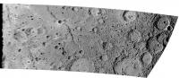
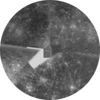
A new limb view, a new reprojection...
Phil
-------------------- ... because the Solar System ain't gonna map itself.
Also to be found posting similar content on https://mastodon.social/@PhilStooke Maps for download (free PDF: https://upload.wikimedia.org/wikipedia/comm...Cartography.pdf NOTE: everything created by me which I post on UMSF is considered to be in the public domain (NOT CC, public domain) |
|
|
|
|
|
|
Oct 17 2008, 02:41 PM
Post
#120
|
|
|
Interplanetary Dumpster Diver Group: Admin Posts: 4404 Joined: 17-February 04 From: Powell, TN Member No.: 33 |
These work better with flatter worlds!
-------------------- |
|
|
|
|
Oct 19 2008, 04:59 PM
Post
#121
|
||
 Senior Member Group: Members Posts: 1669 Joined: 5-March 05 From: Boulder, CO Member No.: 184 |
QUOTE (Phil Stooke @ Oct 6 2008, 07:59 PM) This is a rough fit of the inbound coverage to Steve's map, to give an idea of the locations of features. I took IanR's image (above) and projected it to make the terminator a straight line, then overlaid it on Steve's map and fiddled with the scales until there was a reasonable match between features in the radar images and these new navigation images. There are about 10 or 12 matches between radar and messenger, so I think it's roughly correct. I emphasize roughly though, as the distortions to fit this to the map are very ad hoc. Following up on this placement, here is how a new test version of my map shows the Flyby 2 coverage. It's interesting how the previous radar coverage matches the Messenger images, such as in the multi-ringed crater near the upper left limb of the approach crescent image.
Steve |
|
|
|
|
|
|
Oct 20 2008, 01:18 AM
Post
#122
|
|
|
Senior Member Group: Members Posts: 1276 Joined: 25-November 04 Member No.: 114 |
That looks great!
Can't wait to see final product! 
|
|
|
|
|
Oct 22 2008, 01:40 PM
Post
#123
|
|
|
Senior Member Group: Members Posts: 1075 Joined: 21-September 07 From: Québec, Canada Member No.: 3908 |
A new image from flyby 2 on the Messenger website.
|
|
|
|
|
Oct 25 2008, 06:01 PM
Post
#124
|
||
|
Senior Member Group: Members Posts: 1669 Joined: 5-March 05 From: Boulder, CO Member No.: 184 |
Here's the full resolution post Decepticon...
http://laps.noaa.gov/albers/sos/sos.html#MERCURY Also shown here at slightly lower resolution as an attachment:
Steve |
|
|
|
|
|
|
Oct 25 2008, 10:51 PM
Post
#125
|
|||
|
Solar System Cartographer Group: Members Posts: 10227 Joined: 5-April 05 From: Canada Member No.: 227 |
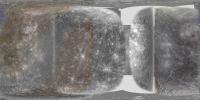
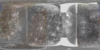
Here's Steve's new map in polar equidistant azimuthal projection. North:
and South:
Phil -------------------- ... because the Solar System ain't gonna map itself.
Also to be found posting similar content on https://mastodon.social/@PhilStooke Maps for download (free PDF: https://upload.wikimedia.org/wikipedia/comm...Cartography.pdf NOTE: everything created by me which I post on UMSF is considered to be in the public domain (NOT CC, public domain) |
||
|
|
|
||
|
Oct 26 2008, 01:32 AM
Post
#126
|
|
|
Merciless Robot Group: Admin Posts: 8785 Joined: 8-December 05 From: Los Angeles Member No.: 602 |
Beautiful...and distinctly alien. This is not the Moon's bigger brother.
-------------------- A few will take this knowledge and use this power of a dream realized as a force for change, an impetus for further discovery to make less ancient dreams real.
|
|
|
|
|
Oct 26 2008, 02:50 PM
Post
#127
|
|
|
Senior Member Group: Members Posts: 1669 Joined: 5-March 05 From: Boulder, CO Member No.: 184 |
Phil's north polar projection nicely illustrates the rays emanating from that crater at a high northern latitude. Looks like in both polar regions we see (mostly from radar) some craters where ice is suspected.
I might be able to expand the usage of a Mariner 10 south polar region image in the map. However there are apparently other high resolution Mariner 10 images near the south pole that could be added. An example would be if I can find an image that looks similar to this link below without the labels (and projected from a spacecraft point of view). http://upload.wikimedia.org/wikipedia/comm...alia_region.jpg Here is one such image mosaic that may work even if it's a bit contrasty looking: http://photojournal.jpl.nasa.gov/catalog/PIA03101 The Chao-Meng Fu (very close to the south pole) and Bernini craters region would be the most interesting. http://en.wikipedia.org/wiki/Chao_Meng-Fu_(crater) So perhaps with these and other images if anyone can point to any I can improve the south polar appearance. Steve |
|
|
|
|
Oct 30 2008, 02:28 PM
Post
#128
|
|
|
Member Group: Members Posts: 544 Joined: 17-November 05 From: Oklahoma Member No.: 557 |
Latest news from MESSENGER.
More of Mercury The pictures, graphs, and accompaning caption stories from the new conference yesterday: Science results from NASA conference Edit - Some more stuff: Diverse color Close up color Exospheric magnesium Solar wind interaction Exosphere comparison |
|
|
|
|
Oct 30 2008, 07:00 PM
Post
#129
|
|
|
Solar System Cartographer Group: Members Posts: 10227 Joined: 5-April 05 From: Canada Member No.: 227 |
The lack of a hemispherical dichotomy is interesting, though not surprising since they are likely to be the result of random events, the biggest survivable impacts. Particularly interesting to me, though not mentioned, is the small number of large basins. A few more might appear in the areas of high sun or near-limb imaging, or the small gaps still remaining, but it looks now as if Caloris is the only big basin. The Moon has quite a few roughly Caloris-sized basins (within a factor of 2 diameter, I mean) on a smaller surface.
Phil -------------------- ... because the Solar System ain't gonna map itself.
Also to be found posting similar content on https://mastodon.social/@PhilStooke Maps for download (free PDF: https://upload.wikimedia.org/wikipedia/comm...Cartography.pdf NOTE: everything created by me which I post on UMSF is considered to be in the public domain (NOT CC, public domain) |
|
|
|
|
Nov 8 2008, 11:59 PM
Post
#130
|
|
|
Senior Member Group: Members Posts: 1669 Joined: 5-March 05 From: Boulder, CO Member No.: 184 |
It's proving to be interesting to navigate the Mariner South Polar mosaic (middle link two posts up) in a consistent way with the other imagery. The location of Bach from the Mariner 10 basemap (and USGS Gazeteer) at latitude -68.5 S appears to be inconsistent with the position of the south polar crater Chao-Meng Fu in the map from the top link. This map has Bach straddling the -70 S line. My next step is to try and match the Mariner SP mosaic with the -68.5 S location of Bach. I'll be curious to see if the South Pole with this solution remains inside Chao-Meng Fu. Perhaps the Wikipedia position of this crater (87.3 S, 132 W) may be a good reference point as well.
In Phil's polar projection one can see the circular feature in the underlying radar data that looks like it may in fact be Chao-Meng Fu. A cursory glance suggests that the location seems consistent with the narration above, and with the suggestion that the South Pole may lie barely outside the rim of this crater. The south pole mosaic looks to be able to improve the resolution of my map south of around 55 S latitude, or maybe a bit further north. Steve |
|
|
|
|

|
Lo-Fi Version | Time is now: 24th September 2024 - 04:09 PM |
|
RULES AND GUIDELINES Please read the Forum Rules and Guidelines before posting. IMAGE COPYRIGHT |
OPINIONS AND MODERATION Opinions expressed on UnmannedSpaceflight.com are those of the individual posters and do not necessarily reflect the opinions of UnmannedSpaceflight.com or The Planetary Society. The all-volunteer UnmannedSpaceflight.com moderation team is wholly independent of The Planetary Society. The Planetary Society has no influence over decisions made by the UnmannedSpaceflight.com moderators. |
SUPPORT THE FORUM Unmannedspaceflight.com is funded by the Planetary Society. Please consider supporting our work and many other projects by donating to the Society or becoming a member. |
|