Jezero Delta Campaign, Sols 414-1000, 21 Apr 2022- 23 Dec 2023 |

  |
Jezero Delta Campaign, Sols 414-1000, 21 Apr 2022- 23 Dec 2023 |
 May 1 2022, 04:49 PM May 1 2022, 04:49 PM
Post
#61
|
|||
 Member  Group: Members Posts: 670 Joined: 9-May 21 From: Germany Member No.: 9017 |
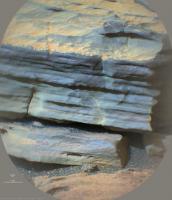
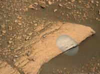
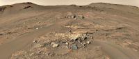
Here comes a sol 424 SuperCam RMI mosaic of the presumed siltstone/mudstone with sol 423 Mastcam-Z context.
The graininess in the bluish-gray parts of the SuperCam image is most likely image noise. Possible mineral grains are too small to be visible. If there are grains, their diameter should be less than 0.15 mm assuming that at least 3 pixels are necessary to resolve a grain. The vertical sequence of laser shots in the center of the SuperCam mosaic indicates that a chemical-mineralogical analysis is in progress.
|
||
 |
 
|
||
|
May 1 2022, 07:48 PM
Post
#62
|
|
 Member Group: Members Posts: 856 Joined: 9-September 17 From: UK Member No.: 8241 |
-------------------- |
|
|
|
|
May 1 2022, 09:26 PM
Post
#63
|
|
|
Senior Member Group: Members Posts: 2998 Joined: 30-October 04 Member No.: 105 |
QUOTE (HSchirmer @ May 1 2022, 08:19 AM)  Snippity-snip Meanwhile- What's that? Everyone's looking at the silt layers, what's with the 'worm castings?" I'm not willing to stick my neck out on that just yet!! Aeolian weathering can create the strangest shapes!! --Bill -------------------- |
|
|
|
|
May 1 2022, 09:42 PM
Post
#64
|
|
|
Senior Member Group: Members Posts: 2998 Joined: 30-October 04 Member No.: 105 |
QUOTE (serpens @ May 1 2022, 12:54 AM) If you are right that the deposition was fallout in the lake prior to delta formation Bill then couldn't the banded layers reflect variations in oxygenation conditions within the lake? Assuming an abiotic influence, say periodic changes in cloud or ash cover affecting levels of UV at the surface and potentially shallow water. Absolutely. In (polluted) terrestrial waters you can have low dissolved oxygen due to BOD (Biological Oxygen Demand) and COD (Chemical Oxygen Demand). The chemistry of the water can scavenge oxygen. And still water in the bottom of a basin or Cup (  ) can certainly produce anoxic zones. ) can certainly produce anoxic zones. --Bill -------------------- |
|
|
|
|
May 2 2022, 09:54 AM
Post
#65
|
||||
|
Member Group: Members Posts: 670 Joined: 9-May 21 From: Germany Member No.: 9017 |
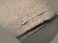
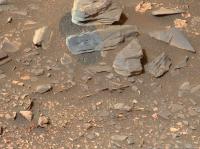
Sol 424 SuperCam RMI mosaic no. 2 with Mastcam-Z context and sol 422 Navcam context
|
|||
|
|
|
|||
|
May 2 2022, 10:04 AM
Post
#66
|
||||
|
Member Group: Members Posts: 670 Joined: 9-May 21 From: Germany Member No.: 9017 |
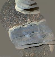
Sol 425 SuperCam RMI mosaic with sol 423 Mastcam-Z context and sol 422 Navcam context
|
|||
|
|
|
|||
|
May 2 2022, 11:29 AM
Post
#67
|
||
 Member Group: Members Posts: 684 Joined: 24-July 15 Member No.: 7619 |
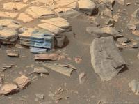
QUOTE (tau @ May 2 2022, 11:04 AM) Sol 425 SuperCam RMI mosaic ...
Interesting shapes- they remind me a bit of the raindrop casts you find in some eastern USA Triassic red shales. Anyone heard any guesses on what size raindrops on Mars would grow to? |
|
|
|
|
|
|
May 2 2022, 11:57 AM
Post
#68
|
|
 Member Group: Members Posts: 593 Joined: 20-April 05 Member No.: 279 |
QUOTE (HSchirmer @ May 2 2022, 12:29 PM) Anyone heard any guesses on what size raindrops on Mars would grow to? I know Ralph Lorenz has 'previous' on this matter! In brief - it appears to depend on the atmospheric pressure. Andy |
|
|
|
|
May 2 2022, 07:09 PM
Post
#69
|
||||
|
Solar System Cartographer Group: Members Posts: 10162 Joined: 5-April 05 From: Canada Member No.: 227 |
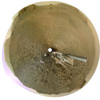
We have had some really nice panoramas posted by Damia and Thomas recently, certainly much better than I could manage. I have been playing with circular versions of them so here are some examples.
Damia, sol 419:
Thomas, sol 422:
and the same with some contrast enhancement and other processing:
And we just had another drive, this time to the east, looking like we will approach an interesting outcrop north of where we are now. Phil -------------------- ... because the Solar System ain't gonna map itself.
Also to be found posting similar content on https://mastodon.social/@PhilStooke Maps for download (free PD: https://upload.wikimedia.org/wikipedia/comm...Cartography.pdf NOTE: everything created by me which I post on UMSF is considered to be in the public domain (NOT CC, public domain) |
|||
|
|
|
|||
|
May 3 2022, 06:11 PM
Post
#70
|
|
|
Solar System Cartographer Group: Members Posts: 10162 Joined: 5-April 05 From: Canada Member No.: 227 |
Just reporting in from the MEPAG meeting. Ken Farley reports that the rover will now move back to the Three Forks area and up into Hawksbill Gap. It will survey outcrops on the way up, then sample them on the way down. At the end of 2022 it will be back at Three Forks and that may be the site of the first sample cache, because it is so flat and benign for operation of the later sample collection missions. Then Perseverance will climb onto the delta top for more sampling. It is possible that the cache will be closer to the crater Belva on the delta top, some time in 2023, but there is a desire to get a good cache safely deployed fairly soon. Later the rover moves to the main channel of the delta and finally up onto the crater rim in about 2024. A second cache would be further southwest after more sampling.
Phil -------------------- ... because the Solar System ain't gonna map itself.
Also to be found posting similar content on https://mastodon.social/@PhilStooke Maps for download (free PD: https://upload.wikimedia.org/wikipedia/comm...Cartography.pdf NOTE: everything created by me which I post on UMSF is considered to be in the public domain (NOT CC, public domain) |
|
|
|
|
May 3 2022, 08:08 PM
Post
#71
|
||
|
Solar System Cartographer Group: Members Posts: 10162 Joined: 5-April 05 From: Canada Member No.: 227 |
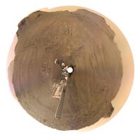
This is Damia's panorama for sol 419 (as posted above) but with enhanced contrast and adjusted colour. Changing contrast messes up the colour, which is why I make changes to it. I know it's not realistic.
I have not worked on the latest panorama, hoping someone else will do it first. Phil
-------------------- ... because the Solar System ain't gonna map itself.
Also to be found posting similar content on https://mastodon.social/@PhilStooke Maps for download (free PD: https://upload.wikimedia.org/wikipedia/comm...Cartography.pdf NOTE: everything created by me which I post on UMSF is considered to be in the public domain (NOT CC, public domain) |
|
|
|
|
|
|
May 4 2022, 02:23 AM
Post
#72
|
||
|
Senior Member Group: Members Posts: 1074 Joined: 21-September 07 From: Québec, Canada Member No.: 3908 |
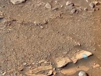
Sol 425 RMastcam-Z (34mm):
|
|
|
|
|
|
|
May 5 2022, 06:56 AM
Post
#73
|
||
|
Solar System Cartographer Group: Members Posts: 10162 Joined: 5-April 05 From: Canada Member No.: 227 |
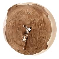
sol 426, a circular panorama with lots of aeolian bedforms AKA drifty-like ripply-like objects.
Phil
-------------------- ... because the Solar System ain't gonna map itself.
Also to be found posting similar content on https://mastodon.social/@PhilStooke Maps for download (free PD: https://upload.wikimedia.org/wikipedia/comm...Cartography.pdf NOTE: everything created by me which I post on UMSF is considered to be in the public domain (NOT CC, public domain) |
|
|
|
|
|
|
May 5 2022, 09:05 AM
Post
#74
|
||
 Senior Member Group: Members Posts: 2428 Joined: 30-January 13 From: Penang, Malaysia. Member No.: 6853 |
More of those lovely aeolian bedforms (See Phil's post) this time after the drive on sol 428 (site 24-1970)
|
|
|
|
|
|
|
May 5 2022, 11:22 AM
Post
#75
|
|
 Senior Member Group: Members Posts: 1619 Joined: 12-February 06 From: Bergerac - FR Member No.: 678 |
Sol 428 Navcam panoramic. Look at this very nice place !
-------------------- |
|
|
|
|

|
Lo-Fi Version | Time is now: 16th May 2024 - 03:46 AM |
|
RULES AND GUIDELINES Please read the Forum Rules and Guidelines before posting. IMAGE COPYRIGHT |
OPINIONS AND MODERATION Opinions expressed on UnmannedSpaceflight.com are those of the individual posters and do not necessarily reflect the opinions of UnmannedSpaceflight.com or The Planetary Society. The all-volunteer UnmannedSpaceflight.com moderation team is wholly independent of The Planetary Society. The Planetary Society has no influence over decisions made by the UnmannedSpaceflight.com moderators. |
SUPPORT THE FORUM Unmannedspaceflight.com is funded by the Planetary Society. Please consider supporting our work and many other projects by donating to the Society or becoming a member. |
|