Mission: Hayabusa 2 |

  |
Mission: Hayabusa 2 |
| Guest_mcmcmc_* |
 Oct 15 2018, 07:18 AM Oct 15 2018, 07:18 AM
Post
#616
|
|
Guests |
Big real time chart:
https://programmi.000webhostapp.com/hayabus...aya2-dates.html Big real time chart with speed: https://programmi.000webhostapp.com/hayabus...dates-test.html |
 |
 
|
| Guest_mcmcmc_* |
Oct 15 2018, 08:51 AM
Post
#617
|
|
Guests |
|
|
|
|
| Guest_mcmcmc_* |
Oct 15 2018, 02:44 PM
Post
#618
|
|
Guests |
TD1-R1a mission ended, H2 now raising again.

|
|
|
|
|
Oct 15 2018, 08:51 PM
Post
#619
|
|
|
Newbie  Group: Members Posts: 11 Joined: 1-March 10 Member No.: 5237 |
QUOTE (mcmcmc @ Oct 15 2018, 08:40 AM)  Theorical MASCOT size in ONC-T camera crossed 1 pixel, so it could be visible from now on, at least as a bright dot where no bright dots were visible before. MINERVA rovers still around 0.6 pixel. But please note that most of the released images are form ONC-W, which has 1/10 resolution of ONC-T. There is a bright point on these images, north hemisphere, so cannot be Mascot... http://www.hayabusa2.jaxa.jp/galleries/onc...01810150957.jpg http://www.hayabusa2.jaxa.jp/galleries/onc...01810151026.jpg http://www.hayabusa2.jaxa.jp/galleries/onc...01810151055.jpg http://www.hayabusa2.jaxa.jp/galleries/onc...01810151123.jpg |
|
|
|
| Guest_mcmcmc_* |
Oct 16 2018, 07:28 AM
Post
#620
|
|
Guests |
QUOTE (OrbitrapInSpace @ Oct 15 2018, 08:51 PM) There is a bright point on these images, north hemisphere, so cannot be Mascot... http://www.hayabusa2.jaxa.jp/galleries/onc...01810150957.jpg http://www.hayabusa2.jaxa.jp/galleries/onc...01810151026.jpg http://www.hayabusa2.jaxa.jp/galleries/onc...01810151055.jpg http://www.hayabusa2.jaxa.jp/galleries/onc...01810151123.jpg is MASCOT final resting position known? |
|
|
|
| Guest_mcmcmc_* |
Oct 16 2018, 08:04 AM
Post
#621
|
|
Guests |
TD1-R1A mission interactive video now availbale:
https://programmi.000webhostapp.com/hayabus...r(TD1-R1A).html Images source Previous missions: https://programmi.000webhostapp.com/hayabus...or(MASCOT).html https://programmi.000webhostapp.com/hayabus...INERVAII1).html |
|
|
|
|
Oct 16 2018, 07:26 PM
Post
#622
|
|
 Senior Member Group: Members Posts: 1417 Joined: 26-July 08 Member No.: 4270 |
The bright dot was seen before the MASCOT deployment. Link.
-------------------- -- Hungry4info (Sirius_Alpha)
|
|
|
|
|
Oct 17 2018, 02:00 AM
Post
#623
|
||
|
Solar System Cartographer Group: Members Posts: 10145 Joined: 5-April 05 From: Canada Member No.: 227 |
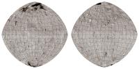
A little something I've been working on...
As time permits I will label the grids and add landing sites, feature names etc. This is a composite of Roman's map and some data from JAXA, but as new material comes out i will improve it. The map projection is an azimuthal equidistant projection modified slightly to represent the familiar diamond-shaped cross-section of Ryugu. Phil
-------------------- ... because the Solar System ain't gonna map itself.
Also to be found posting similar content on https://mastodon.social/@PhilStooke NOTE: everything created by me which I post on UMSF is considered to be in the public domain (NOT CC, public domain) |
|
|
|
|
|
|
Oct 17 2018, 05:00 PM
Post
#624
|
||
|
Solar System Cartographer Group: Members Posts: 10145 Joined: 5-April 05 From: Canada Member No.: 227 |
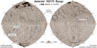
Here is a first map showing the information I have at the moment. The MINERVA location is shown as an ellipse. If anyone has more information on a specific location I would be interested to see it. Are there any other names for features? I haven't seen any.
I will update this as we go. Phil
-------------------- ... because the Solar System ain't gonna map itself.
Also to be found posting similar content on https://mastodon.social/@PhilStooke NOTE: everything created by me which I post on UMSF is considered to be in the public domain (NOT CC, public domain) |
|
|
|
|
|
|
Oct 18 2018, 06:23 AM
Post
#625
|
|
 Senior Member Group: Members Posts: 1079 Joined: 19-February 05 From: Close to Meudon Observatory in France Member No.: 172 |
QUOTE (Phil Stooke @ Oct 17 2018, 07:00 PM) Here is a first map showing the information I have at the moment. The MINERVA location is shown as an ellipse. If anyone has more information on a specific location I would be interested to see it. Are there any other names for features? I haven't seen any. I will update this as we go. Phil Phil, you are the best  as usual as usual 
|
|
|
|
|
Oct 19 2018, 02:23 AM
Post
#626
|
|
|
Member Group: Members Posts: 156 Joined: 22-May 09 From: Ireland Member No.: 4792 |
What can one say...Phil
|
|
|
|
| Guest_mcmcmc_* |
Oct 19 2018, 07:53 AM
Post
#627
|
|
|
Guests |
QUOTE (Phil Stooke @ Oct 17 2018, 05:00 PM) Here is a first map showing the information I have at the moment. The MINERVA location is shown as an ellipse. If anyone has more information on a specific location I would be interested to see it. Are there any other names for features? I haven't seen any. I will update this as we go. Phil
Wherer did JAXA publish information about Lat0-Lon0 point? About the 3d model, did anybody successfully build an high-res one, now that hundreds of images are available? I am collecting all of them: http://programmi.000webhostapp.com/hayabus...ayer-index.html |
|
|
|
|
|
|
Oct 19 2018, 11:39 AM
Post
#628
|
|
 Member Group: Members Posts: 112 Joined: 20-August 12 From: Spain Member No.: 6597 |
QUOTE (mcmcmc @ Oct 19 2018, 07:53 AM) Wherer did JAXA publish information about Lat0-Lon0 point? About the 3d model, did anybody successfully build an high-res one, now that hundreds of images are available? I am collecting all of them: http://programmi.000webhostapp.com/hayabus...ayer-index.html I have tried with the latest available images, but no luck creating a good 3D model, at least not with the software I'm using 
|
|
|
|
|
Oct 19 2018, 05:02 PM
Post
#629
|
|
|
Solar System Cartographer Group: Members Posts: 10145 Joined: 5-April 05 From: Canada Member No.: 227 |
"Where did JAXA publish information about Lat0-Lon0 point?"
It's in this JAXA press conference PDF: http://global.jaxa.jp/projects/sat/hayabus...ss20180719e.pdf And of course, it is also illustrated in every JAXA map since then which includes a coordinate grid. Phil -------------------- ... because the Solar System ain't gonna map itself.
Also to be found posting similar content on https://mastodon.social/@PhilStooke NOTE: everything created by me which I post on UMSF is considered to be in the public domain (NOT CC, public domain) |
|
|
|
|
Oct 19 2018, 10:39 PM
Post
#630
|
|
 Member Group: Members Posts: 101 Joined: 3-May 12 From: Massachusetts, USA Member No.: 6392 |
A 3D digital shape model of Ryugu has been created by Mattias Malmer, and he has physically printed a copy as well. (I hope he doesn't mind me sharing this information.)
|
|
|
|
|

|
Lo-Fi Version | Time is now: 16th April 2024 - 10:38 PM |
|
RULES AND GUIDELINES Please read the Forum Rules and Guidelines before posting. IMAGE COPYRIGHT |
OPINIONS AND MODERATION Opinions expressed on UnmannedSpaceflight.com are those of the individual posters and do not necessarily reflect the opinions of UnmannedSpaceflight.com or The Planetary Society. The all-volunteer UnmannedSpaceflight.com moderation team is wholly independent of The Planetary Society. The Planetary Society has no influence over decisions made by the UnmannedSpaceflight.com moderators. |
SUPPORT THE FORUM Unmannedspaceflight.com is funded by the Planetary Society. Please consider supporting our work and many other projects by donating to the Society or becoming a member. |
|