Exploring Mt Sharp - The Dunes - Part 2: Naukluft Plateau, Sites 53-54, Sols 1274-1352, March 7-May 27 2016 |

  |
Exploring Mt Sharp - The Dunes - Part 2: Naukluft Plateau, Sites 53-54, Sols 1274-1352, March 7-May 27 2016 |
 Mar 16 2016, 12:11 PM Mar 16 2016, 12:11 PM
Post
#46
|
||
 Senior Member  Group: Members Posts: 2428 Joined: 30-January 13 From: Penang, Malaysia. Member No.: 6853 |
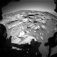
FL HazCam: Midnight Planets reports a drive of approximately 38.5m W (-99º) on Sol 1283. Not enough NavCams for the 360 mosaic yet...
|
|
 |
 
|
|
|
Mar 16 2016, 02:12 PM
Post
#47
|
||
 Member Group: Members Posts: 334 Joined: 11-December 12 From: The home of Corby Crater (Corby-England) Member No.: 6783 |
A partial NavCam anaglyph from Sol1283, a lot of transforming going on so a bit ropey in the extremeties

|
|
|
|
|
|
|
Mar 16 2016, 02:41 PM
Post
#48
|
|
 Administrator Group: Admin Posts: 5172 Joined: 4-August 05 From: Pasadena, CA, USA, Earth Member No.: 454 |
QUOTE (atomoid @ Mar 15 2016, 07:04 PM)  I was trying to figure out the little hole in the sand sol1278 which seems to have been poked sometime between sol1276 and sol1277, from the MAHLI instrument? If the MAHLI prongs made contact with anything, it would halt the motion of the arm. Holes are generally caused by ChemCam. Here's the before and the after. -------------------- My website - My Patreon - @elakdawalla on Twitter - Please support unmannedspaceflight.com by donating here.
|
|
|
|
|
Mar 16 2016, 04:13 PM
Post
#49
|
|
|
Member Group: Members Posts: 923 Joined: 10-November 15 Member No.: 7837 |
-------------------- |
|
|
|
|
Mar 16 2016, 11:32 PM
Post
#50
|
|
|
Senior Member Group: Members Posts: 2428 Joined: 30-January 13 From: Penang, Malaysia. Member No.: 6853 |
Curiosity Mission Update from Ken Herkenhoff (March 16th) Sol 1284: Driving Across the Plateau
QUOTE MSL drove almost 40 meters over the rough terrain on the Naukluft plateau, as planned, and again there are many interesting features near the rover. Many of the rocks appear to have been abraded by windblown sand, resulting in some bizarre shapes in places. The chemical and morphological diversity of these nearby rocks will be sampled before the rover drives toward the west on Sol 1284: ChemCam and Mastcam will observe outcrop targets named "Rooirand," "Grootberg," and "Gratzplatz." The Left Mastcam will also acquire mosaics of the outcrop around Rooirand and sedimentary structures to the south of the rover. After the drive, the usual post-drive imaging is planned, including a MARDI twilight image (my only responsibility today).
|
|
|
|
|
Mar 17 2016, 02:16 AM
Post
#51
|
|
|
Member Group: Members Posts: 306 Joined: 4-October 14 Member No.: 7273 |
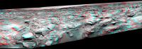
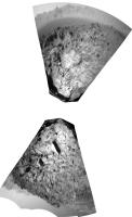
Here's the RMI mosaic. It's spectacular!
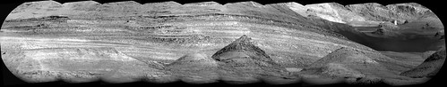 It looks like the mound in center foreground has had the entire right side blasted off. There's also a neat hoodoo-like feature hiding in the background at right, and you can get a better sense of its profile by its shadow on the cliff behind it. What a scene! |
|
|
|
|
Mar 17 2016, 05:07 AM
Post
#52
|
|
|
Senior Member Group: Members Posts: 2083 Joined: 13-February 10 From: Ontario Member No.: 5221 |
That damage would have been caused by an impact, right?
|
|
|
|
|
Mar 17 2016, 06:09 AM
Post
#53
|
|
|
Member Group: Members Posts: 306 Joined: 4-October 14 Member No.: 7273 |
An impact was my first guess, but I can think of a couple other things that it might be. If a stream was running off Mt. Sharp, it might have undercut the mound and caused landslides until the slope stabilized at where we see it. It could also be a minor fault network that weakened that half of the mound and allowed it to erode more quickly. I'm not exactly sure where this mosaic was looking, but an orbital context shot would probably be useful in figuring out exactly what's going on.
|
|
|
|
|
Mar 17 2016, 12:11 PM
Post
#54
|
|
|
Member Group: Members Posts: 923 Joined: 10-November 15 Member No.: 7837 |
-------------------- |
|
|
|
|
Mar 17 2016, 01:36 PM
Post
#55
|
||
|
Senior Member Group: Members Posts: 2822 Joined: 22-April 05 From: Ridderkerk, Netherlands Member No.: 353 |
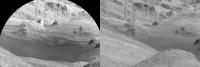
The Navcam L view on Sol 1283.
Jan van Driel
|
|
|
|
|
|
|
Mar 17 2016, 07:13 PM
Post
#56
|
|||
|
Solar System Cartographer Group: Members Posts: 10154 Joined: 5-April 05 From: Canada Member No.: 227 |
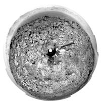
Thanks, Jan - here is a circular view from sol 1283:
and a projection of the Hazcams for sol 1284:
Phil -------------------- ... because the Solar System ain't gonna map itself.
Also to be found posting similar content on https://mastodon.social/@PhilStooke Maps for download (free PD: https://upload.wikimedia.org/wikipedia/comm...Cartography.pdf NOTE: everything created by me which I post on UMSF is considered to be in the public domain (NOT CC, public domain) |
||
|
|
|
||
|
Mar 17 2016, 10:40 PM
Post
#57
|
|
|
Member Group: Members Posts: 866 Joined: 15-March 05 From: Santa Cruz, CA Member No.: 196 |
QUOTE (jccwrt @ Mar 16 2016, 11:09 PM) An impact was my first guess, but I can think of a couple other things that it might be. If a stream was running off Mt. Sharp, it might have undercut the mound and caused landslides until the slope stabilized at where we see it. It could also be a minor fault network that weakened that half of the mound and allowed it to erode more quickly. I'm not exactly sure where this mosaic was looking, but an orbital context shot would probably be useful in figuring out exactly what's going on. incredibly impressive fantastic imagery, thanks. its such a good view from here i hope we get some m100s for follow-up. One of the more striking ones is the vertical cliff (hoodoo?) and just love the little ripples in the foreground. I was under the impression the current surface is tens(?) of meters underneath the layers of the final wet epochs, suggesting long term wind action as a cause of undermining the blasted-off hillside (all that detritus oblated to some other locale), but could just as much consider the blasted-off appearance to be a well-preserved relic of that original stream-erosion, itself only recently exhumed. It just looks so fresh, but there doesn't seem to be anywhere for all that to have gone but there may be plenty of room down there. |
|
|
|
|
Mar 17 2016, 11:03 PM
Post
#58
|
|||
 Senior Member Group: Members Posts: 4246 Joined: 17-January 05 Member No.: 152 |
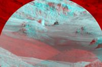
It is a very cool looking area. Here's a stereo view using the 1181 MR with the 1283 RMI. The baseline gives a pretty severe stereo effect. Anaglyph:
Cross-eyed:
The bright, nearly vertical face towards the back was mostly hiding behind a foreground knob in the MR view. There was another view on 1270, but that was only ML so it doesn't show much. There is a new MR view in the pipeline... |
||
|
|
|
||
|
Mar 17 2016, 11:20 PM
Post
#59
|
||
|
Senior Member Group: Members Posts: 2428 Joined: 30-January 13 From: Penang, Malaysia. Member No.: 6853 |
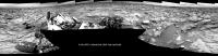
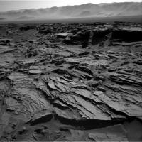
4Days, 4 Drives
1284 L-NavCam mosaic, roughly assembled in MS ICE, dimensions reduced to fit the upload limits
|
|
|
|
|
|
|
Mar 18 2016, 12:48 AM
Post
#60
|
||
|
Senior Member Group: Members Posts: 2428 Joined: 30-January 13 From: Penang, Malaysia. Member No.: 6853 |
Curiosity Mission Update from Lauren Edgar, March 17th - Sol 1285: Still driving across the Naukluft Plateau
QUOTE Curiosity is still working her way across the Naukluft Plateau. On Sol 1284 Curiosity drove ~27 m, which brings our total traverse distance to ~12,549 m. Todays plan is fairly straightforward. In the morning, Curiosity will acquire Mastcam and ChemCam on targets named Mulden and Koigab to characterize the bedrock that weve been driving over. Well also take a Mastcam mosaic to investigate the local stratigraphy. Then Curiosity will continue driving towards the northwest, and will take post-drive imaging to prepare for contact science over the weekend. Early the next morning, Curiosity will take several Navcam, Mastcam, and ChemCam observations to monitor the atmospheric composition and opacity and search for clouds. Ill be on duty tomorrow as GSTL, so Im looking forward to planning some contact science!
|
|
|
|
|
|
|

|
Lo-Fi Version | Time is now: 1st May 2024 - 08:18 AM |
|
RULES AND GUIDELINES Please read the Forum Rules and Guidelines before posting. IMAGE COPYRIGHT |
OPINIONS AND MODERATION Opinions expressed on UnmannedSpaceflight.com are those of the individual posters and do not necessarily reflect the opinions of UnmannedSpaceflight.com or The Planetary Society. The all-volunteer UnmannedSpaceflight.com moderation team is wholly independent of The Planetary Society. The Planetary Society has no influence over decisions made by the UnmannedSpaceflight.com moderators. |
SUPPORT THE FORUM Unmannedspaceflight.com is funded by the Planetary Society. Please consider supporting our work and many other projects by donating to the Society or becoming a member. |
|