Opportunity Route Map |

  |
Opportunity Route Map |
 Aug 21 2006, 12:47 PM Aug 21 2006, 12:47 PM
Post
#1801
|
|
 Member  Group: Members Posts: 656 Joined: 20-April 05 From: League City, Texas Member No.: 285 |
QUOTE (mcaplinger @ Aug 20 2006, 11:30 PM)  For what purpose? We know where the rover is, and it's hard to improve on s11-471 for route planning. Can't get a much more precise position fix, in terms of synchronizing rover position to ground imagery, than identifying a pixel (or several) in that imagery that is known to be the rover at a given time. |
 |
 
|
|
Aug 21 2006, 12:59 PM
Post
#1802
|
|
|
Junior Member Group: Members Posts: 21 Joined: 5-July 06 Member No.: 955 |
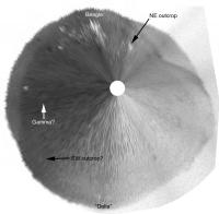
QUOTE (Tesheiner @ Aug 20 2006, 02:07 PM) You should be quick or Oppy will run by that rock before we can locate it!  Updated route map for sol 914. [attachment=7068:attachment] I'm astounded and delighted with the progress that Oppy is making toward Victoria crater. From the overhead satellite pictures,I assumed that the Victoria ejecta blanket would be full of loose sand and imposing dunes. The NASA team indicated that this journey would take a month but as of this moment it appears that the arrival could be much sooner. Also, I wonder if the unexpected reboot of the rover at Beagle crater caused the sudden rush to get to Victoria crater. I would also like to thank Tesheiner and the rest of the mapper makers very much for your outstanding work and you guys have really made this rover experience much more enjoyable. Thanks. |
|
|
|
|
Aug 21 2006, 02:20 PM
Post
#1803
|
|
 Senior Member Group: Members Posts: 4246 Joined: 17-January 05 Member No.: 152 |
Tesheiner, Delta is visible in the latest navcams - in principle the angular separation between Delta and Epsilon would help fix our location. (Technically it would confine us to a curve - I'm not sure of the shape of the curve, but it wouldn't be hard to work out.) In practice they're both not very well defined...
Gamma crater would help even more - I've looked for Gamma but can't see it in navcam. |
|
|
|
|
Aug 21 2006, 02:54 PM
Post
#1804
|
|
|
Senior Member Group: Moderator Posts: 4279 Joined: 19-April 05 From: .br at .es Member No.: 253 |
I've seen that when the navcams were downlinked --actually, almost all features commonly seen only on the pancams are currently visible on the navcams too-- so I made a polar projection of that navcam mosaic to use on the route map (I usually do it) and see how it fits when compared with the basemap.
The result is that there are some discrepancies; the problem is that given the poor resolution and distortion on the navcams I can't tell which sol 914 position is wrong; if the one you can currently see on my route map or the one provided by using the navcam polar projection. That's why I want to wait until we are closer to Epsilon (end of this week?) to gather some precise heading and distance measurements and then refine the route. |
|
|
|
|
Aug 21 2006, 03:11 PM
Post
#1805
|
|
 Senior Member Group: Members Posts: 2492 Joined: 15-January 05 From: center Italy Member No.: 150 |
QUOTE (fredk @ Aug 21 2006, 02:20 PM) (Technically it would confine us to a curve - I'm not sure of the shape of the curve, but it wouldn't be hard to work out.) I think a simple circle in a vertical plane, intercepting surface in only two points... too simple? -------------------- I always think before posting! - Marco -
|
|
|
|
|
Aug 21 2006, 04:03 PM
Post
#1806
|
|
|
Senior Member Group: Members Posts: 4246 Joined: 17-January 05 Member No.: 152 |
I don't quite get you dilo - it might be an ellipse in general, I'll work it out though.
|
|
|
|
|
Aug 21 2006, 10:28 PM
Post
#1807
|
|
|
Member Group: Senior Member Posts: 136 Joined: 8-August 06 Member No.: 1022 |
QUOTE (algorimancer @ Aug 21 2006, 05:47 AM) Can't get a much more precise position fix, in terms of synchronizing rover position to ground imagery, than identifying a pixel (or several) in that imagery that is known to be the rover at a given time. As you probably are aware from the MOC website, we've done this for both rovers. But it's expensive, in terms of MGS operations, and as Mike pointed out, we do know where the rover is with respect to the MOC images that have been taken. -Tim. |
|
|
|
|
Aug 22 2006, 03:14 AM
Post
#1808
|
||
|
Solar System Cartographer Group: Members Posts: 10150 Joined: 5-April 05 From: Canada Member No.: 227 |
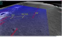
Here is an example of a truly bizarre vertical stretch of the latest navcam pan, made into a polar. This was mhoward's pan, and I cropped out just a thin strip - maybe 100 pixels or so high - from a 7000 pixel wide pan, made it 3000 by 3000 and did a polar of it. At this level of stretching various distant features become apparent, including crater Delta (as shown on Tesheiner's map), possibly crater Gamma, and a couple of outcrops which are obvious on his route map. Several other dark spots ahead of us are clear as well. This is enough to triangulate a decent position. The flatter an area is, the more useful this sort of trick is.
Also, of course, it shows the distant relief really well. The broad depression north of Victoria, the double horizon west of the current location, etc. Phil
-------------------- ... because the Solar System ain't gonna map itself.
Also to be found posting similar content on https://mastodon.social/@PhilStooke NOTE: everything created by me which I post on UMSF is considered to be in the public domain (NOT CC, public domain) |
|
|
|
|
|
|
Aug 22 2006, 03:33 AM
Post
#1809
|
|
 Senior Member Group: Members Posts: 2228 Joined: 1-December 04 From: Marble Falls, Texas, USA Member No.: 116 |
I stand corrected. They'll *never* put you in a box. ...and I learned something valuable about polar projections that should have been, but wasn't previously apparent to me. Thanks.

-------------------- ...Tom
I'm not a Space Fan, I'm a Space Exploration Enthusiast. |
|
|
|
|
Aug 22 2006, 03:14 PM
Post
#1810
|
||
 Member Group: Members Posts: 239 Joined: 20-April 05 From: Bruxelles, Belgium Member No.: 278 |
My first estimate for sol 916 , but i think is correct ...
Attached thumbnail(s)
-------------------- |
|
|
|
|
|
|
Aug 22 2006, 04:07 PM
Post
#1811
|
||
|
Senior Member Group: Moderator Posts: 4279 Joined: 19-April 05 From: .br at .es Member No.: 253 |
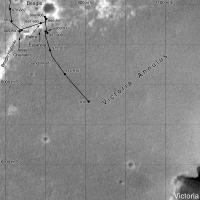
My route map, updated to sol 916.
|
|
|
|
|
|
|
Aug 22 2006, 05:42 PM
Post
#1812
|
|
|
Member Group: Members Posts: 540 Joined: 17-November 05 From: Oklahoma Member No.: 557 |
Everyone got their seat belt strapped on?
|
|
|
|
|
Aug 22 2006, 05:43 PM
Post
#1813
|
|
 Member Group: Members Posts: 578 Joined: 5-November 04 From: Denmark Member No.: 107 |
QUOTE (Holder of the Two Leashes @ Aug 22 2006, 07:42 PM) Everyone got their seat belt strapped on? Everyone got their image stitchers warmed up? This is gonna be huge
-------------------- "I want to make as many people as possible feel like they are part of this adventure. We are going to give everybody a sense of what exploring the surface of another world is really like"
- Steven Squyres |
|
|
|
|
Aug 23 2006, 01:32 AM
Post
#1814
|
||
|
Solar System Cartographer Group: Members Posts: 10150 Joined: 5-April 05 From: Canada Member No.: 227 |
My latest position.
Phil
-------------------- ... because the Solar System ain't gonna map itself.
Also to be found posting similar content on https://mastodon.social/@PhilStooke NOTE: everything created by me which I post on UMSF is considered to be in the public domain (NOT CC, public domain) |
|
|
|
|
|
|
Aug 23 2006, 02:37 AM
Post
#1815
|
|
|
Member Group: Members Posts: 656 Joined: 20-April 05 From: League City, Texas Member No.: 285 |
Here's my estimate of Opportunity's position on Sol 916.
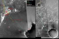
I used the position(s) for Hawking Rock which I'd determined using wide baseline photogrammetry from Oppy's positions on Sols 887 and 904 (see the posting in the Route Map thread). Using AlgorimancerPG I measured the range and azimuth to Hawking Rock from the Sol 916 pancam images, finding an azimuth of 158.3 degrees and range of 95 +/-10 meters. I used this information to predict the Sol 916 position, entirely based upon that azimuth, range, and error, plus also estimated the east-west error in the Hawking Rock position (likely worst case). Here are the results (big file, 4.4 Megs, yes I could make it smaller, but I have other priorities at the moment): http://www.clarkandersen.com/R1500822_NWVi..._Hawking916.PNG The colored pixels are the predicted positions as exact offsets from the Hawking predictions. The bounding quadrilateral is an estimate of the error range. The white cross is the current position from Tesheiner's route map, the white circle is an estimate of the position from Phil Stooke's route map (it was harder to match up the exact position on that one). I'm pretty happy with the results. Tesheiner's position falls neatly within my error region. I may have misplaced Phil's position. This makes me a bit more confident in my Hawking position  Looking forward to the next move. |
|
|
|
|

|
Lo-Fi Version | Time is now: 23rd April 2024 - 11:08 PM |
|
RULES AND GUIDELINES Please read the Forum Rules and Guidelines before posting. IMAGE COPYRIGHT |
OPINIONS AND MODERATION Opinions expressed on UnmannedSpaceflight.com are those of the individual posters and do not necessarily reflect the opinions of UnmannedSpaceflight.com or The Planetary Society. The all-volunteer UnmannedSpaceflight.com moderation team is wholly independent of The Planetary Society. The Planetary Society has no influence over decisions made by the UnmannedSpaceflight.com moderators. |
SUPPORT THE FORUM Unmannedspaceflight.com is funded by the Planetary Society. Please consider supporting our work and many other projects by donating to the Society or becoming a member. |
|