

Intuitive Machines IM-1 mission, CLPS mission with NASA and commercial payloads |

  |
Intuitive Machines IM-1 mission, CLPS mission with NASA and commercial payloads |
 Feb 26 2024, 06:49 PM Feb 26 2024, 06:49 PM
Post
#121
|
||
|
Solar System Cartographer  Group: Members Posts: 10160 Joined: 5-April 05 From: Canada Member No.: 227 |
Could be, John.
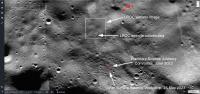
Here is the location of the site in an image I posted earlier, showing different targets mentioned before landing. Phil
-------------------- ... because the Solar System ain't gonna map itself.
Also to be found posting similar content on https://mastodon.social/@PhilStooke Maps for download (free PD: https://upload.wikimedia.org/wikipedia/comm...Cartography.pdf NOTE: everything created by me which I post on UMSF is considered to be in the public domain (NOT CC, public domain) |
|
 |
 
|
|
|
Feb 26 2024, 07:00 PM
Post
#122
|
||
|
Member Group: Members Posts: 106 Joined: 25-November 04 From: Dublin, Ireland Member No.: 113 |
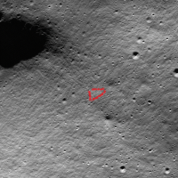
QUOTE (john_s @ Feb 26 2024, 05:44 PM)  The LROC blink image also shows a new bright patch next to the lander- arrowed here. Could that indicate a bounce? [attachment=54671:odysseus...oc_annot.png] John I inerpret that as the descent plume. But there is also a suggestion of a much wider and much fainter fan-shaped disturbance in the blink image that may or may not mean something. IM-1 in the Moon
|
|
|
|
|
|
|
Feb 26 2024, 08:19 PM
Post
#123
|
|
|
Solar System Cartographer Group: Members Posts: 10160 Joined: 5-April 05 From: Canada Member No.: 227 |
Great observation. I hadn't noticed until you pointed it out.
Phil -------------------- ... because the Solar System ain't gonna map itself.
Also to be found posting similar content on https://mastodon.social/@PhilStooke Maps for download (free PD: https://upload.wikimedia.org/wikipedia/comm...Cartography.pdf NOTE: everything created by me which I post on UMSF is considered to be in the public domain (NOT CC, public domain) |
|
|
|
|
Feb 27 2024, 01:23 AM
Post
#124
|
|
|
Solar System Cartographer Group: Members Posts: 10160 Joined: 5-April 05 From: Canada Member No.: 227 |
https://twitter.com/ILOA_Hawaii/status/1762203591962767780
ILO has images on the ground, hi-res apparently, and will be shared soon. Phil -------------------- ... because the Solar System ain't gonna map itself.
Also to be found posting similar content on https://mastodon.social/@PhilStooke Maps for download (free PD: https://upload.wikimedia.org/wikipedia/comm...Cartography.pdf NOTE: everything created by me which I post on UMSF is considered to be in the public domain (NOT CC, public domain) |
|
|
|
|
Feb 27 2024, 03:37 AM
Post
#125
|
|
|
Senior Member Group: Members Posts: 2516 Joined: 13-September 05 Member No.: 497 |
FWIW, DSS-56 Madrid is receiving data at 50 kbps from Lunar Node 1 right now.
-------------------- Disclaimer: This post is based on public information only. Any opinions are my own.
|
|
|
|
|
Feb 27 2024, 11:54 AM
Post
#126
|
|
|
Member Group: Members Posts: 200 Joined: 20-November 05 From: Mare Desiderii Member No.: 563 |
Various of the outlets reporting on IM's prognosis of going dark today suggest EagleCam won't get a chance to deploy (dunno if based on an actual source).
E.g., Space News, which links to the EagleCam team's update page (last updated Sunday), which has some details of how it will/would deploy: QUOTE We are currently running simulations which show that EagleCam should deploy a total distance of somewhere between 3 to 5 meters, with a best guess at about 4.1 meters QUOTE The imagery would then be transferred via Wi-Fi back to the lander and then transmitted down to engineers on Earth for analysis
|
|
|
|
|
Feb 27 2024, 01:46 PM
Post
#127
|
|
|
Senior Member Group: Members Posts: 2085 Joined: 13-February 10 From: Ontario Member No.: 5221 |
QUOTE (mcaplinger @ Feb 26 2024, 10:37 PM) FWIW, DSS-56 Madrid is receiving data at 50 kbps from Lunar Node 1 right now. 62.6 now. Better late than never! |
|
|
|
|
Feb 27 2024, 04:29 PM
Post
#128
|
|
|
Member Group: Members Posts: 200 Joined: 20-November 05 From: Mare Desiderii Member No.: 563 |
Update from IM's update page dated <2h ago:
QUOTE Lunar Surface Day Five Update Flight Controllers continue to communicate with Odysseus. This morning, Odysseus efficiently sent payload science data and imagery in furtherance of the Company’s mission objectives. Flight controllers are working on final determination of battery life on the lander, which may continue up to an additional 10-20 hours. The images included here are the closest observations of any spaceflight mission to the south pole region of the Moon. Odysseus is quite the photographer, capturing this image approximately 30 meters above the lunar surface while his main engine throttled down more than 24,000 mph. Another day of exploration on the south pole region of the Moon. 2/27/24 0845 CST Has five small images in a carousel; full-resolution versions (by hand-hacking the URLs) linked here individually for convenience: UPDATE-CSYS-1, -2, -3, -4, -5. |
|
|
|
|
Feb 27 2024, 10:02 PM
Post
#129
|
|
|
Senior Member Group: Members Posts: 2516 Joined: 13-September 05 Member No.: 497 |
https://arstechnica.com/space/2024/02/it-tu...altimetry-data/ has some interesting items. Apparently more images will be released tomorrow.
As for whether this was a success -- I'm reminded of one of my favorite quotes about the Scott expedition: QUOTE I now see very plainly that though we achieved a first-rate tragedy, which will never be forgotten just because it was a tragedy, tragedy was not our business. -- Apsley Cherry-Garrard, The Worst Journey in the World -------------------- Disclaimer: This post is based on public information only. Any opinions are my own.
|
|
|
|
|
Feb 27 2024, 10:20 PM
Post
#130
|
|
|
Member Group: Members Posts: 200 Joined: 20-November 05 From: Mare Desiderii Member No.: 563 |
The article mentions a press conference tomorrow. IM's site confirms that will be at 2pm ET (19:00 UTC).
|
|
|
|
|
Feb 28 2024, 06:54 PM
Post
#131
|
|
|
Member Group: Members Posts: 200 Joined: 20-November 05 From: Mare Desiderii Member No.: 563 |
Pre-press-conference "day six update" from a little over four hours ago. Not much info beyond "Odysseus continues to generate solar power on the Moon" and implication it was still talking.
Yesterday I set up logging for GHY-6 (aka 'DSS-59', apparently) status (should have thought of it earlier). Haven't fully digested logs yet, but so far I can see that in last night's IM-1 session, GHY-6 was transmitting on S-band between 0300 and 0710 GMT (possibly not continuously, haven't checked), and at no point did the GHY-6's S-band receiver show as being 'in lock'. (Yesterday's Eric Berger article talked about them using IM-1's 'powerful Quasonix transmitter' for the first time; dunno if/how that would affect the reported status.) |
|
|
|
|
Feb 28 2024, 07:11 PM
Post
#132
|
|
|
Senior Member Group: Members Posts: 2085 Joined: 13-February 10 From: Ontario Member No.: 5221 |
Wow, now that's a broken leg!
|
|
|
|
|
Feb 28 2024, 07:14 PM
Post
#133
|
|||
 Member Group: Members Posts: 185 Joined: 4-January 19 Member No.: 8523 |
More upright that they initially thought...
Tilted 45o?
Attached thumbnail(s)
-------------------- "The Earth is a very small stage in a vast cosmic arena"
|
||
|
|
|
||
|
Feb 28 2024, 08:15 PM
Post
#134
|
|
|
Senior Member Group: Members Posts: 2085 Joined: 13-February 10 From: Ontario Member No.: 5221 |
Eaglecam was ejected, but no images yet....
|
|
|
|
|
Feb 28 2024, 09:42 PM
Post
#135
|
|
|
Member Group: Members Posts: 200 Joined: 20-November 05 From: Mare Desiderii Member No.: 563 |
Bits and pieces I took away from the press conference not already mentioned:
|
|
|
|
|

|
Lo-Fi Version | Time is now: 13th May 2024 - 02:50 PM |
|
RULES AND GUIDELINES Please read the Forum Rules and Guidelines before posting. IMAGE COPYRIGHT |
OPINIONS AND MODERATION Opinions expressed on UnmannedSpaceflight.com are those of the individual posters and do not necessarily reflect the opinions of UnmannedSpaceflight.com or The Planetary Society. The all-volunteer UnmannedSpaceflight.com moderation team is wholly independent of The Planetary Society. The Planetary Society has no influence over decisions made by the UnmannedSpaceflight.com moderators. |
SUPPORT THE FORUM Unmannedspaceflight.com is funded by the Planetary Society. Please consider supporting our work and many other projects by donating to the Society or becoming a member. |
|


 so they landed on opnav/IMU alone. Didn't realise they had landed without lidar until day 3 after landing, when they started getting telemetry data down. (In response to Jeff Foust, Irene Klotz)