Perseverance Route Map |

  |
Perseverance Route Map |
 May 5 2024, 01:48 PM May 5 2024, 01:48 PM
Post
#406
|
||
 Member  Group: Members Posts: 669 Joined: 9-May 21 From: Germany Member No.: 9017 |
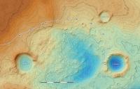
QUOTE (Glevesque @ May 3 2024, 04:58 PM)  I don't know if any of you know the diameter of these three craters located north of the Perseverance landing site: "La Orotava", "Hahoots'aa", "Port Angeles. . . . " Diameters of craters measured on the crater rim (rough estimates, because they are not perfect circles): La Orotava 330 m Port Angeles 180 m Hahóóts'aa 320 m
|
|
 |
 
|
|
|
May 5 2024, 03:29 PM
Post
#407
|
|
 Member Group: Members Posts: 118 Joined: 19-November 14 From: Québec Member No.: 7339 |
Thanks tau
-------------------- |
|
|
|
|
May 8 2024, 04:06 PM
Post
#408
|
||
|
Member Group: Members Posts: 669 Joined: 9-May 21 From: Germany Member No.: 9017 |
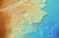
QUOTE (Glevesque @ May 3 2024, 04:58 PM) . . . I am also looking for the list of Sols for each kilometers covered. (1 km = Sol 130 (02-07-2021), 2 km = Sol 177 (19-08-2021), 3 km = ?, etc...) . . . Here is my attempt to create a map of kilometer marks and the sols when the rover reached them. For calculation I used the json file under "Rover Drive Path" in the Perseverance's location map. The first complication I encountered was that the individual drives are not in chronological order. The rover seemed to be jumping around. After re-arranging them in chronolocical order, a continuous polyline was created for calculation of the kilometer marks. As cartographical projection (which has influence on the calculated lengths) I applied an equidistant cylindrical projection with standard parallel at 18.4663°N (the center of the planned landing ellipse) on a spherical Mars with a radius of 3396190 m, which is most likely the projection used in the json files and JPL's location map. Then I tried to find out the UTC date and time on Earth when the kilometer marks were reached by the rover. There are two entries in the json drive path file for every drive: SCLK_START and SCLK_END (SCLK= spacecraft clock). They are counted in seconds which can be correlated to UTC. But the time between start and end of an individual drive is in some cases more than one Earth day, on sol 340 even more than five days which obviously is not real. Maybe, it is possible to narrow down the time interval of the drive with the help of the raw images, where the large number following the sol number in the file name is the SCLK time when the image was taken. If I'm not wrong, the clock seems to be a little bit slow, about 0.7 seconds behind per day.
|
|
|
|
|
|
|
May 8 2024, 04:26 PM
Post
#409
|
|
|
Senior Member Group: Members Posts: 2516 Joined: 13-September 05 Member No.: 497 |
QUOTE (tau @ May 8 2024, 09:06 AM) ...the clock seems to be a little bit slow, about 0.7 seconds behind per day. According to https://naif.jpl.nasa.gov/pub/naif/MARS2020...KSCET.00009.tsc the clock has been a little fast relative to UTC over most of the mission (if I have the sense of the correction right). It would be tough to figure out exactly which images correspond most closely to the end of a drive. I'm not sure why the JSON file has the problems you describe. If I were going to do this, I would look at https://naif.jpl.nasa.gov/pub/naif/MARS2020...f_rover_loc.bsp which contains 52 site coordinates, but I've always been a little unsure how sites correlate to drives. I think short drives don't change the site? -------------------- Disclaimer: This post is based on public information only. Any opinions are my own.
|
|
|
|
|
May 8 2024, 05:56 PM
Post
#410
|
|
|
Member Group: Members Posts: 118 Joined: 19-November 14 From: Québec Member No.: 7339 |
A big thank you tau. I will adjust my narrative in volume 2 to include the mileage (km) traveled by Perseverance.
THANKS tau -------------------- |
|
|
|
|

|
Lo-Fi Version | Time is now: 13th May 2024 - 11:34 PM |
|
RULES AND GUIDELINES Please read the Forum Rules and Guidelines before posting. IMAGE COPYRIGHT |
OPINIONS AND MODERATION Opinions expressed on UnmannedSpaceflight.com are those of the individual posters and do not necessarily reflect the opinions of UnmannedSpaceflight.com or The Planetary Society. The all-volunteer UnmannedSpaceflight.com moderation team is wholly independent of The Planetary Society. The Planetary Society has no influence over decisions made by the UnmannedSpaceflight.com moderators. |
SUPPORT THE FORUM Unmannedspaceflight.com is funded by the Planetary Society. Please consider supporting our work and many other projects by donating to the Society or becoming a member. |
|