Cape York DEM |

Cape York DEM |
 Jul 15 2011, 09:32 PM Jul 15 2011, 09:32 PM
Post
#1
|
||||||||
 Member  Group: Members Posts: 656 Joined: 20-April 05 From: League City, Texas Member No.: 285 |
pgrindrod was kind enough to share his DEM of western Endeavour with me (thank you
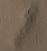
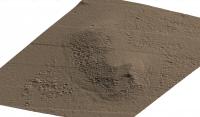
 ); this is the same DEM he used to generate the visibility maps about Cape York. Following much effort spread over a couple of weeks (largest data set I've ever worked with), I was able to convert it to an STL file format and snip-out the vicinity of Cape York (once I found it) so that I could get a sense of scale. While there's a good drop-off to the east (nearly 30 meters), Cape York doesn't rise much above the plains approaching from the west. ); this is the same DEM he used to generate the visibility maps about Cape York. Following much effort spread over a couple of weeks (largest data set I've ever worked with), I was able to convert it to an STL file format and snip-out the vicinity of Cape York (once I found it) so that I could get a sense of scale. While there's a good drop-off to the east (nearly 30 meters), Cape York doesn't rise much above the plains approaching from the west. Here's an overview image, with north at top. I have illumination coming from the west at an angle of 30 degrees from horizontal. There is no vertical exaggeration.
The wedge/valley feature at the northeast corner is not very prominent here (perhaps it is more albedo feature than topological). As I recall, the resolution of the DEM is about .3 meters vertically on about a 1-meter grid. The dunes to the east show nicely, as does the crater that Oppy's headed towards at the south. Here's a profile view from the west. The target crater is hidden by a small rise to the right.
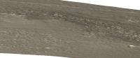
Here's a profile view from the south. The target crater is to the left, and you can get a sense of topography and how the ground descends rapidly to the east (right). There is no vertical exaggeration in any of these views.
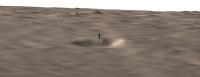
Here's a close-up view of the target crater from the south with a 2 meter figure standing near the north rim to provide scale. Cape York rises gently behind it.
Here's an oblique view from the north of Cape York -- you can just see the 2 meter figure as a blueish spike in the distance, though the crater it stands next to is hidden.
Another oblique view from the southest, where the 2 meter figure is just visible by the crater to the lower right.
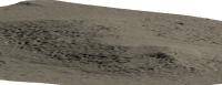
An oblique view from the northeast, nicely showing the dunes to the east (left) and all of Cape York.
And that's enough images for one post. Apologies for the color -- I tried a couple of variations. Enjoy. Credit goes to pgrindrod for the DEM and assistance in converting it to a format I could work with. |
|||||||
 |
 
|
|||||||
 algorimancer Cape York DEM Jul 15 2011, 09:32 PM
 Stu Genuinely brilliant work, well done.
Looks like ... Jul 16 2011, 12:15 AM Phil Stooke Don't worry, Stu, we can fix that.
Phil Jul 16 2011, 12:18 AM algorimancer Glad you like it. For context, here's the bea... Jul 17 2011, 01:33 PM fredk I vote for topography. The lighting (from the wes... Jul 17 2011, 03:39 PM Stu While I don't believe in an Emerald City anymo... Jul 17 2011, 03:54 PM algorimancer Here's the topography spanning the north end o... Jul 18 2011, 03:35 PM algorimancer I did 4 height transects, 3 near the north of CY a... Jul 18 2011, 07:25 PM
Stu Genuinely brilliant work, well done.
Looks like ... Jul 16 2011, 12:15 AM Phil Stooke Don't worry, Stu, we can fix that.
Phil Jul 16 2011, 12:18 AM algorimancer Glad you like it. For context, here's the bea... Jul 17 2011, 01:33 PM fredk I vote for topography. The lighting (from the wes... Jul 17 2011, 03:39 PM Stu While I don't believe in an Emerald City anymo... Jul 17 2011, 03:54 PM algorimancer Here's the topography spanning the north end o... Jul 18 2011, 03:35 PM algorimancer I did 4 height transects, 3 near the north of CY a... Jul 18 2011, 07:25 PM
 MoreInput It's just about 10% slope down to the bottom, ... Jul 18 2011, 08:53 PM algorimancer The target crater may be a bit underwhelming.
Jul 20 2011, 05:19 PM
MoreInput It's just about 10% slope down to the bottom, ... Jul 18 2011, 08:53 PM algorimancer The target crater may be a bit underwhelming.
Jul 20 2011, 05:19 PM  |

|
Lo-Fi Version | Time is now: 27th April 2024 - 09:18 AM |
|
RULES AND GUIDELINES Please read the Forum Rules and Guidelines before posting. IMAGE COPYRIGHT |
OPINIONS AND MODERATION Opinions expressed on UnmannedSpaceflight.com are those of the individual posters and do not necessarily reflect the opinions of UnmannedSpaceflight.com or The Planetary Society. The all-volunteer UnmannedSpaceflight.com moderation team is wholly independent of The Planetary Society. The Planetary Society has no influence over decisions made by the UnmannedSpaceflight.com moderators. |
SUPPORT THE FORUM Unmannedspaceflight.com is funded by the Planetary Society. Please consider supporting our work and many other projects by donating to the Society or becoming a member. |
|