Printable Version of Topic
Click here to view this topic in its original format
Unmanned Spaceflight.com _ Spirit _ Sliding into 'Home Plate North'
Posted by: Astro0 Nov 2 2007, 04:55 AM
So, perhaps a new topic is warranted now that the MER team has decided on the location for Spirit's 2008 winter retreat - 'Home Plate North'. (See: http://www.planetary.org/news/2007/1031_Mars_Exploration_Rovers_Update_Spirit.html)
So, first question to our UMSF team - 'Could someone pinpoint the winter location on a Hi-Rise photo of Home Plate?'
|
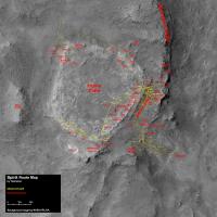
Tesheiner's route map (above).
I note with interest, that the last time I started a topic on Spirit (http://www.unmannedspaceflight.com/index.php?s=&showtopic=3446&view=findpost&p=74530) it was on November 7th, 2006. As I write this, it's November 2nd 2007 and we are seeing the Rovers move into their THIRD Martian year (coming up to four Earth years).
An incredible achievement, an incredible journey, and it's not over yet!
Astro0
Posted by: dvandorn Nov 2 2007, 05:07 AM
I really think Spirit ought to traverse along the western edge of HP to get to the north slopes. I'm still intrigued by the large crack that runs parallel to the west edge -- I can think of a lot less interesting places to visit on HP than that long crack.
If we're going to find anything different on top of HP than we found along the edges, that crack is the first palce I'd be looking for it.
-the other Doug
Posted by: alan Nov 2 2007, 07:13 PM

Astro0
The steepest north facing part of Home plate is the area where Spirit first arrived. I suspect they selected a spot 10 m east of Gibson.
Posted by: Stu Nov 2 2007, 08:15 PM
So we'll be resting up near my fave ever rock, "Mackay"? 
Posted by: peter59 Nov 2 2007, 10:49 PM
I'm completly dissapointed. Spirit's days are really counted,
only 355 watt-hours 4 or 5 months before winter. Undoubtedly
it's last Spirit's weeks, maybe months. It's very bad decision,
Goodard / von Braun should be the last target.
Posted by: djellison Nov 2 2007, 10:52 PM
Drive to Goddard and Spirit WILL die.
Drive somewhere with better slopes, and it probably wont and Goddard will still be there next Spring.
It's a no brainer. Given our very low power experience of the dust storm- there's no reason to think this winter will be any less survivable than the last.
Excessive doom-mongering or misinformation (such as 'Undoubtedly it's last Spirit's weeks') are utterly unjustified and will not be tolerated on this forum.
Doug
Posted by: brellis Nov 3 2007, 02:11 AM
It's amazing how longterm the planning has gotten for these rovers. If they are still working at the time of MSL's arrival, the comm relay schedule will get pretty crowded!
Speculative question: could there come a time when budget constraints limit the mission, or force planners to send the rovers to riskier targets in order to fit an arbitrary mission time frame? That would be very unfortunate.
Posted by: CosmicRocker Nov 3 2007, 04:23 AM
Well, the decision to delay the visit to von Braun until the next Martian spring is yet another brutal reminder of the realities of 'extreme' robotic exploration on an alien planet. I don't know that attempting a drive to von Braun/Goddard "WILL" result in Spirit's demise, but I've learned over the past several years not to second-guess the "rover handlers." They obviously know what it is they are doing.  I interpret the long term planning as well-earned optimism. I probably would have voted for a less conservative layover, but the recent global dust storm has taught us just how valuable 10 watt-hrs can be when sunlight is limited.
Posted by: nprev Nov 3 2007, 05:53 AM
Been thinking about that. I think that the chief limiting factor will be DSN coverage, which in addition to rising maintenance problems will also be tasked to support several other missions at the same time. I'm sure that there's a scheduling solution at least under development, but it will definitely be a challenge.
Posted by: Astro0 Nov 4 2007, 06:15 AM
The DSN has always risen to these sorts of challenges.
Data return is number one along with maintenance - infact the majority is preventative maintenance rather than reactionary.
There have been some problems recently (Madrid's 70-metre bearing and pump filter problems come to mind), but other than that, the DSN continues to be the unsung heroes of space exploration. You don't leave here, get there and return cool data without us.
The downshift in current budgets is definitely tight, but the sheer dedication of the people working at the three antenna communication complexes will see it through.
Astro0
Posted by: climber Nov 4 2007, 04:14 PM
I interpret the long term planning as well-earned optimism. I probably would have voted for a less conservative layover, but the recent global dust storm has taught us just how valuable 10 watt-hrs can be when sunlight is limited.I (hate) to agree on that. I'd have liked the agressive plan to get to VB/G and not spend a full (very long) winter with no move even if the location will be visualy very nice. But we have so many experiences in mind, not only regarding Rovers, where JPL just did the right decision. You're talking about long term planning and I think that they're already planning what we're going to do this winter.
Hope they'll find a new "heaven"

Posted by: fredk Nov 4 2007, 05:50 PM
I was mostly surprised by the abruptness of the decision. Obviously that's a sign of the seriousness of the power situation this coming winter. I might have thought they'd get better imagery of the route towards von Braun/Goddard first, by driving a bit towards the "Saddle". In particular, the feature called Crossfield hasn't been imaged very well, and could have provided north-facing slopes along the route. Still, the imagery we have, plus the stereo hirise imagery, don't look promising.
There definitely appear to be very steep north facing slopes high enough up on von Braun, but the problem is driving up its slopes with five wheels. Perhaps more promising was the north facing outside rim of Goddard. But the pancam imagery looks like the approach may be slippery.
In the end, the north side of homeplate is easy to get to, and we don't have to drive upwards onto the slope, so we're essentially guaranteed to be able to get into a favourable position.
Posted by: fredk Nov 4 2007, 07:44 PM
http://qt.exploratorium.edu/mars/spirit/navcam/2007-11-03/2N247374350EFFAWCCP0615R0M1.JPG
Posted by: Aussie Nov 4 2007, 11:12 PM
It probably wasn't all that abrupt - we were just not privy to the decision making process and expected Spirit to thunder off in the direction of VB without delay. But the power situation does seem serious. During the storm the power levels were comparable to what we can expect this winter but the dust provided a warmer environment. While Spirit can probably survive the winter it will be a close run thing and we can not expect much work. But then again, she had surprised us with cleaning events before.
Posted by: dvandorn Nov 5 2007, 07:11 AM
Lovely! That crack is a little thinner than it looks from above... but the system still looks constructional to me (as opposed to dessicative).
Oh, how I wish we still had a working RAT on Spirit! I'd love to take a good close look at the vertical faces in the top 10cm of the crack (i.e., the exposed face).
-the other Doug
Posted by: tanjent Nov 5 2007, 04:11 PM
It will be nice to know the wintering target location if someone can figure that out. Looking at CosmicRocker's anaglyph on the map thread it does indeed seem that the best slopes might be found near the site of Spirit's first HP encounter circa sol 750. Of course I am not sure if the map orientation is precisely north-top. If not, Tesh might want to add a little pointer to the next edition of his map.
Pessimism may be unjustified, but the abrupt change of direction is difficult to understand unless they are really worried that the remaining fallout may curtail mobility unexpectedly and much sooner than originally planned. That little crack referred to by o'Doug seemed like a very tempting target, and anyway why turn back when you're already more than 180 degrees around unless the drivers have quite suddenly come to fear tackling unfamiliar terrain? Or perhaps the target location might be over by Fuzzy Smith, site of the second ascent on sol 768. To one who is not well equipped to savor the full significance of the science results (as opposed to the scenic attractions...) it seems to wind up a rather disappointing Mars Year for Spirit since the first arrival in the HP area.
I do hope she will see another spring, but in my blithe ignorance of the inside information behind the latest urgency to hunker down I sense a bit too much risk aversion on behalf of a girl who literally represents the human spirit. As Stu might cite it:
Yet all experience is an arch wherethrough
Gleams that untravelled world, whose margin fades
For ever and for ever when I move.
How dull it is to pause, to make an end,
To rust unburnished, not to shine in use!
(OK now before nostalgia sets in let's repeat the Blue Mars mantra - Gotta keep that much perspective on the situation.)
We're on Mars! We're on Mars! We're on Mars!
tanjent
Posted by: djellison Nov 5 2007, 04:43 PM
When poetry provides Whr's - let me know.
Until that point, the conservative option of heading for local, known, accessible, power positive slopes opens the opportunity for another full summer of exploration next year. The braver option might bring us those two new geological features more quickly - but it could very well eliminate the chance for any exploration beyond. i.e. an over zealous exploratory nature now, would eradicate further exploration in the future.
If you ignore the romance and the speculation and the 'desire' for exploration and simply put on a hat marked 'sensible' - they're doing the right thing. The right decision is rarely the most popular or exciting one.
Doug
Posted by: BrianL Nov 5 2007, 05:44 PM
Never been an "armchair quarterback", Doug? (or whatever the equivalent over there is).
Anyway, I am still hopeful that they might play it by ear over the next few weeks, and perhaps extend the exploration a bit based on power levels and mobility at the time, before finally hunkering down on a sunny slope. I think the situation is much more forgiving this year. The terrain is known to be rover friendly, not like last time when Spirit was faced with a long trip over unknown territory that ultimately proved to be impassable.
Brian
Posted by: fredk Nov 5 2007, 05:46 PM
I would add the following observation. From what we've heard, it sounds like von Braun/Goddard are the next science targets the team is most interested in. Power levels on Spirit are currently sufficient for driving and science, and (depending on how favourable the surface is en route) they could probably make a good shot at reaching vB/G before winter. So I would argue that if the planners thought the odds were poor that we would survive another winter at Home Plate North, then for the sake of maximizing science return an attempt would be made to reach vB/G immediately. This would be done with the understanding that she would probably not survive this coming winter, so it would be her final target. Drive to vB/G as quickly as possible and study it as much as possible before her final Big Sleep.
But this hasn't happened, and so the fact that she's been sent to HP North with its more favourable and easily accessible slopes suggests to me that they think the odds are reasonable that she will survive another winter and continue to vB/G next year. That's good news. As frustrating as it is to have to wait until another Martian spring, I'd certainly prefer long term life to a brief final hurrah.
Posted by: djellison Nov 5 2007, 05:53 PM
You've not seen me watch an F1 race
Doug
Posted by: climber Nov 5 2007, 06:30 PM
I have to agree to this but, come on, once we'll stop in the right spot that'll be another 7 months waiting for spring to bloom with no move at all.
OK, that wayyyyy shorter than waiting for NH to get to Jupiter. Anyway I'm having hard time to figure out how our F1 fan can be facinated by such a slow vehicule.

Posted by: Holder of the Two Leashes Nov 5 2007, 06:45 PM
I've read that they're going to put Spirit on a 25 degree slope. I wonder if it can get back up that slope on five wheels, or whether they will have to drive on down in the spring?
Posted by: TheChemist Nov 5 2007, 06:45 PM
Maybe he's a Jenson Button fan
Posted by: djellison Nov 5 2007, 07:00 PM
My two favorite vehicles of all time - Thrust SSC, and MER - just about the fastest and slowest vehicles made my man.
My two favorite noises - a BRM H16, and a Delta II
Technology, engineering - I love it - in any form.
Doug
Posted by: Tesheiner Nov 7 2007, 01:49 PM
Yes it is.
Posted by: Astro0 Nov 13 2007, 09:33 PM
Is it just me, or has it gone a bit quiet on both threads at the moment 
The '08 winter haven 'North Homeplate' intrigues me. Where will it be and what sort of science can we do at this location?
Here's a little SFX image - no idea if the scale is right nor the location, but perhaps we can get some discussion going on the question above.

|
Enjoy
Astro0
Posted by: climber Nov 13 2007, 10:03 PM
Enjoy
Astro0
I love when Spirit is pointing her camera toward us

Posted by: mhoward Nov 13 2007, 10:36 PM
Actually that's approximately where "Gibson" was (if I'm remembering the name correctly) - where we first arived at Home Plate, more or less on the west side (or maybe northwest). The north side would be to the left in your mosaic. Spirit's winter home might be off the left-hand side, even, IMHO. As for scale, I would say pretty good guess, maybe a little too big. Still, I reckon your rendition gives a pretty good idea what Spirit's winter home will look like.
The tracking data isn't entirely accurate, but here's what it shows for Spirit at Gibson:
http://www.flickr.com/photo_zoom.gne?id=2007454454&context=photostream&size=l
http://www.flickr.com/photo_zoom.gne?id=2006662035&size=l
Posted by: fredk Nov 13 2007, 10:43 PM
Astro0, thanks for the image. I'd say that the NHP site would be quite a bit farther to the left in your image, maybe roughly centred left-right. You've got her pointing more east west than north.
Even a very good northwards tilt only gives you a good solar illumination angle near noon. It would be very cool to see Spirit parked on an inclined cyllinder-shaped slope, so she could roll to several positions during the day to follow the sun, basking lizard-style as I've written before. I could see this working to some extent if she parked near the extreme NW corner of HP. Of course in reality even a very short drive may cost more energy than you gain. And in her current state she likely would slide irreversibly downslope with each short drive. Fun to imagine though.
"Is it just me, or has it gone a bit quiet on both threads at the moment?"
It's not just you! Lack of movement from Oppy helps. Spirit moved on sol 1371, but no navcams are in yet. I estimate from the hazcams that she's now roughly halfway from the 1363 to the 759 positions (and a bit east).
Posted by: Shaka Nov 13 2007, 10:56 PM
Astro0,
Unless I'm badly disoriented, it appears that you have put Spirit around the NW corner facing more to the West than the North. That would not help us from the standpoint of solar energy over winter. I would look for a place further to the left (east) on the north rim of HP - somewhere where we can ease down over the lip and have enough traction on bedrock to stay put on the upper half of the face. The idea there would be to study with the IDD the upper layers of HP in detail for a month or two; then to go a little farther down, where we would repeat the studies on the middle layers, and ultimately to reach the bottom of the slope. We want a location where we won't lose traction and slide straight to the bottom. Getting back up could be a problem. We don't want to come off the slope until spring insolation allows us to go level and track south along the base of the west side looking for the deepest exposures.
One question needing consideration is whether to descend the north slope with the IDD (and the stuck wheel) ahead of us (and below) or trailing above and behind us. Opinions? 
Edit: Blast, Freddo beat me to the punch! 
Posted by: Shaka Nov 13 2007, 11:09 PM
I don't understand why we are racing north so fast, unless the intent is to scout out our overwintering location first and then go back to study the shiny rocks - they are worthy of scrutiny. It only takes a few sols to cross HP, and I understood that the power crisis was still some weeks away?
Or am I mistaken?
Posted by: djellison Nov 13 2007, 11:12 PM
Currently 320 Whrs - and falling rather fast. Given the fact that mobility with one stuck wheel is always a slight unknown - better to be ahead of the curve toward winter than be near..or behind it.
Doug
Posted by: Shaka Nov 13 2007, 11:24 PM
OK, that is a reasonable precaution. A pity though. Assuming the drop in energy continues at this rate, how long before we must assume the northerly position? (Allowing some safety margin)
Posted by: fredk Nov 14 2007, 01:03 AM
That's a very real possibility. From http://marsrovers.jpl.nasa.gov/mission/status_spiritAll.html#sol1363
And mhoward beat me!
Posted by: fredk Nov 14 2007, 01:15 AM
From http://www.planetary.org/news/2007/1031_Mars_Exploration_Rovers_Update_Spirit.html
Posted by: Astro0 Nov 14 2007, 01:23 AM
Yippee! It worked.
We are talking again
Just because we aren't moving and pictures are a bit thin on the ground, shouldn't mean that we stop the discussion.
While the position wasn't correct (I sort of guessed that) it did get people talking about just where Spirit's drivers will target the rover for its Winter lodgings - and that was my first question when I started this thread.
I think that Shaka raises a very important question, which way will Spirit be oriented on its 25 degree slope - IDD facing upslope or downslope - will the right front wheel be a brake or an anchor?
Watch for a revised SFX image with various people's suggestions incorporated.
Doug - perhaps a 'winter haven guessing pool' is in order to figure out where Spirit will end up.
|
|
I'll go crazy and say it's here!
What does anyone else think?
Astro0
Posted by: Shaka Nov 14 2007, 01:42 AM
I would prefer to find a place considerably closer to the NW corner, where there is a thicker exposure profile (and perhaps greater slope). But before I plunk down my X, I would like to drive along the north rim looking for places where the descent and 'footing' may be more secure. I am worried about the risk of sliding beyond our desired lodging. Getting back up may be impossible.
Gasp...I can TALK! ... Astro0 has cured me! Ta' muchly, Cobber.
Posted by: mhoward Nov 14 2007, 01:51 AM
What does anyone else think?
I think that's the spot I'd guess, as well.
Here's a view looking straight west:
http://www.flickr.com/photo_zoom.gne?id=2008953831&size=l
http://www.flickr.com/photo_zoom.gne?id=2009752112&context=photostream&size=l
I'm guessing home will be on the slope just to the left of the rover model. Not a very exciting spot, perhaps, but a nice, clean, safe slope.
I don't post anaglyphs, but there's a crude anaglyph on the flickr page which helps gain some perspective.
Posted by: djellison Nov 14 2007, 07:54 AM
No. 100,000,000 times no.
A disucssion, a debate, great. But not a 'pool' again. Please. The debate on exactly which point is the actual winter haven and which person is most close to that is just utterly pointless and I don't want to wade through it.
Doug
Posted by: Sunspot Nov 14 2007, 08:07 AM
If they have just 320Whr now, how low do they expect power levels to drop in the depth of winter?
Posted by: Tesheiner Nov 14 2007, 08:31 AM
It's not just you! Lack of movement from Oppy helps. Spirit moved on sol 1371, but no navcams are in yet. I estimate from the hazcams that she's now roughly halfway from the 1363 to the 759 positions (and a bit east).
Yeah, this thread needed a little bump!
And Fredk, based on the rover data from the tracking web I think you are right on the money regarding sol 1371 position. Sol 1373 was a driving sol too and I'm right now trying to update the route map.
Posted by: fredk Nov 14 2007, 06:17 PM
With tosol's drive we've almost completed the circumnavigation of HP. Compare http://qt.exploratorium.edu/mars/spirit/navcam/2007-11-14/2N248257431EFFAWGSP0655R0M1.JPG with http://marsrovers.jpl.nasa.gov/gallery/all/2/n/760/2N193832374EFFAODQP0795R0M1.JPG The old tracks are just barely visible in the new image as light markings - obviously the dust storm has cleaned up after us nicely here. The circular tracks from the 90 degree turn should be easy to make out once we get closer or use pancam.
Posted by: alan Nov 14 2007, 08:34 PM
Looking at Helvick's power chart from last year
http://www.unmannedspaceflight.com/index.php?s=&showtopic=2195&view=findpost&p=68095
it appears that Spirit's power levels dropped by half between sol 704 (sol 1373-669) and the minimum 200 sols later, from 540 W hrs to 270 W hrs.
Spirit's going to need every degree of north tilt it can get.
Posted by: djellison Nov 14 2007, 08:54 PM
We have a filthy rover, and a rapidly coming winter - BUT - we have two things in our favour.
1 : We know we'll have a good slope to drive down onto without worrying about climbing up to a slope
2 : We're VERY good at VERY low power survival following the worst of the dust storm ( i.e. the traditional 240 Whrs minimum was cut almost in half for a while)
Doug
Posted by: Astro0 Nov 14 2007, 09:39 PM
OK Doug. I was just joking about the 'pool'. I know how much people dislike them.
At least we're not talking about whether Spirit will be parking on the 'nearside' or the 'farside' of HP

Just glad to see that we are debating the issue again after 4-5 quite days.
Astro0
Posted by: fredk Nov 14 2007, 10:10 PM
Remembering that the dust storm was summer, and this is winter we're talking about now, so colder temperatures. This will be new territory.
Posted by: climber Nov 14 2007, 10:32 PM
Doug
Can we hold such low level for several months AND do some science or at least communications ?
Posted by: Aussie Nov 14 2007, 11:09 PM
There is a limit to power conservation. The RHU provide 8 W heating but during the dust storm they had to keep the electronics operating to generate sufficient heating to prevent the heaters cutting in. So they will almost certainly do some science and data transmission as a pragmatic way of keeping the WEB above -40C. Since the heaters cut in last winter there is a high probability that they will do so again. Anyone have any knowledge as to the power draw for these heaters?
Posted by: djellison Nov 14 2007, 11:31 PM
That's the way they held such low levels - by doing no science save for a single Tau observation one day in three, and communicating one-day-in-three
Doug
Posted by: Del Palmer Nov 14 2007, 11:51 PM
According to the MER thermal design document at JPL's reference archive, the MiniTES survival heater would consume 55 W on a cold night. Of course, Spirit could opt to use Deep Sleep to avoid survival heater usage at night. During the day, the WEB survival heaters use 60 W, so you'd want to avoid those from kicking in by running the computer for longer periods, as was done on Oppy.
Posted by: djellison Nov 15 2007, 12:02 AM
During the dust storm - they didn't do that. They didn't have the power to run the thing in the afternoon just to pump heat into the system. They just left the basic level circuitry for charging and clock running and the survival heaters kicked in when necessary. The most efficient way to keep the vehicle above a critical temperature is to use a heater when, and only when, it is about to hit that temperature. Anything other than that and you're wasting Whrs keeping the vehicle warmer than it essentially needs to be.
Doug
Posted by: helvick Nov 15 2007, 12:45 AM
Lets get our units straight folks. The resource that we are worried about is Watt-hours [per sol]. The individual systems draw Watts [per second\minute\hour\sol\whatever ] so you have to know the power draw _and_ the duration of the event in order to figure out how much of an issue it might be. My understanding is that the temperature triggered survival heaters draw 15 Watts and the total number of Watt-hours they draw in a given sol depends on when the switches get turned on [ in the evening as temp drops < -40 ] and turned off [ in the early morning as temp rises above something slightly higher than -40].
I can't throw any light on the critical numbers here apart from pointing out that they survived substantially lower power levels during the dust storm than any of us had believed possible before the storm so I am now firmly of the opinion that [a] The rover management team knows best and [b] they will only stop working when they are good and ready.
Posted by: Del Palmer Nov 15 2007, 01:08 AM
Yes, sorry I wasn't clearer. W = Watt-hours per sol.
Posted by: Aussie Nov 15 2007, 05:49 AM
Squires statement from the Planetary Society Update 31 Jan 07: 'What the rover needs to survive in winter is something between 200 and 250 watt-hours'.
Given current power levels I think we can appreciate why an extra 10 Whrs is so critical and why they want to be in place as early as possible.
Posted by: centsworth_II Nov 15 2007, 09:25 PM
Without another cleaning event, does this even look possible?
Posted by: Aussie Nov 16 2007, 02:04 AM
Probably the most cold vulnerable module is the battery pack and I think the -40 C operating limit is a function of battery electrolyte freezing temperature, so this temperature is a critical limit, not a heater activation level. As I understand it heater switching is autonomous and the battery heaters activate at - 20 C. I also believe that 6 of the 8 RHU are dedicated to the battery pack . So rather than the WEB being maintained at a common temperature are there more vulnerable sections within the WEB that have additional insulation and heating, with 'last ditch' WEB survival heaters that activate at -40 C to reduce the temperature gradient from vulnerable areas should electronic activity not provide sufficinet buffering. An incremental defence makes for good energy efficiency. This would certainly maximise the effect of the RHU and explain why the heaters did not kick in last winter until the external temperature dropped to around a - 95 C minimum, but when the electronics were shut down, in the comparatively warm dust storm environment WEB temperatures reached -37 C . Activating some electronic activity was probably a more energy effective way of minimising the temperature gradient and associated risk than survival heaters.
Posted by: fredk Nov 16 2007, 05:26 AM
Tracks from 616 sols ago (that's pushing two years!) visible in the left half, a bit below centre, http://qt.exploratorium.edu/mars/spirit/pancam/2007-11-15/2P248432475EFFAWH6P2422L7M1.JPG
There was a tiny bump on sol 1375. Open up http://qt.exploratorium.edu/mars/spirit/navcam/2007-11-14/2N248257431EFFAWGSP0655R0M1.JPG and http://qt.exploratorium.edu/mars/spirit/navcam/2007-11-15/2N248431770EFFAWH6P0615R0M1.JPG in identically positioned windows and flip from one to the other for a cute flicker animation between the two sites.
Posted by: climber Nov 16 2007, 05:48 PM
May be a wild thought, but anyway.
Instead of hoping for a cleaning event, do you think that the (actual) dust, coat Spirit enough to preserve temperature exchanges with the atmosphere i.e. keep more heat inside ?
Posted by: djellison Nov 16 2007, 06:19 PM
I doubt it makes much of a difference be honest. It's a very thin, very fine layer. Indeed - because it's a lighter colour than the dark solar arrays themselves, it might even make the rover less able to absorb what ever solar heating there is.
Doug
Posted by: Stu Nov 17 2007, 10:27 AM
Time for a few new views, I think...

|
|

|
Posted by: djellison Nov 17 2007, 11:44 AM
Given that we are treating Home Plate as a roundabout - can I just say that I think they went about it the right way - clockwise - and took a wrong turning without asking for directions
Look on the bright side - it could be :
http://en.wikipedia.org/wiki/Magic_Roundabout_(Swindon)
Doug
Posted by: Stu Nov 17 2007, 01:09 PM
Nice mini-trench you cut out for us there, Spirit...

|
Posted by: fredk Nov 17 2007, 06:44 PM
I don't know, Doug, where I come from we go counterclockwise around roundabouts. I think it was perhaps a bit reckless on the drivers' part choosing to go clockwise without checking the local traffic regulations. Very fortunately, they didn't run into any opposing traffic! 
Climber - I think what we really need is for someone to knit a sweater and scarf for Spirit for the winter.
Posted by: climber Nov 17 2007, 07:12 PM
Arfffggg! Have I knew this a bit earlier, I would have asked TPS to propose to board this on Phoenix instead of the CD .
Posted by: fredk Nov 18 2007, 04:27 AM
http://marsrovers.jpl.nasa.gov/mission/tm-spirit/spirit-sol1376.html show a possible winter haven location, marked WH3, together with upcoming stops at sites 7 and 8.
Posted by: alan Nov 18 2007, 07:02 AM
My interpretation of WH3 viewed from sol 742, nice outcrop to examine during the winter, and a convenient ramp below to roll down in the spring:
|
|
and a closeup from sol 767

|
Posted by: Stu Nov 18 2007, 11:08 AM
|
|
|
Loving the layers here...
Posted by: Floyd Nov 18 2007, 02:23 PM
Was the plan to be in the winter haven spot by early January? After exploring site 7 and site 8, do you think there will be time to visit Fuzzy Smith? FS is only about 2 driving days from site 8, and less from WH3. Seems to me that Spirit could do lots of exploring of northern Home Plate as long as we stay within 1-2 day's drive of WH3. Might spirit be moving around examining rocks and taking pictures within 20 feet of WH3 into March and move into final position only when the power stars to drop?
Posted by: dvandorn Nov 18 2007, 06:13 PM
There is one factor that I don't think even the MER drivers are taking into account, here. Winds. Or lack thereof.
Oppy has had several cleaning events since the Storm, and Spirit has had really none. Oppy is in and around a big crater, which intensifies winds. Spirit seems to be in a mostly wind-dead area, a depositional trap more than anything.
If we want Spirit to survive the winter, I think we need to find a wind-positive location somewhere near Home Plate. I'm hoping the north edge will have more winds than LRH did and than we've yet seen, but with all the dust I see deposited at the foot of WH3, I have my doubts...
-the other Doug
Posted by: centsworth_II Nov 18 2007, 06:27 PM
Spirit's wintering may turn out to be more of a nail-biter than the Dust Storm of 2007. 
Posted by: Tesheiner Nov 21 2007, 09:13 AM
Here's the latest navcam mosaic taken on sol 1380.
|
|
Spirit drove "back" a few meters, perhaps looking for a different path to "site 7". Note that the sites explored around sols 750-760 are on the leftmost two frames of the mosaic.
Posted by: djellison Nov 21 2007, 10:23 AM
That's a nice bit of rover donut that'll be visible from HiRISE
Doug
Posted by: fredk Nov 21 2007, 04:29 PM
I certainly don't want to raise alarm bells unnecessarily, but I'm starting to wonder about Spirit. Are her movements the past week or so intentional or is she struggling to leave this area? It's hard to tell from the current imagery, including Tesheiner's nice pan, but she's actually in a bit of a hollow right now. You can see it in http://marsrovers.jpl.nasa.gov/gallery/all/2/n/759/2N193748672EFFAODQP0695R0M1.JPG We're currently in the depression that slopes down to the right behind the rocky outcrops in the foreground.
Anyone gather any clues from pancam database?
Posted by: jamescanvin Nov 21 2007, 04:57 PM
I don't see any indications of anything unusual in the tracking database.
I don't know what Spirit is up to, but I'm not worried at the moment.
James
Posted by: Tesheiner Nov 22 2007, 09:13 AM
This is my guess (no info to support it, for the time being): They attempted to continue moving north on sols 1375 and 1378 but the drives were aborted due to excessive slippage. The move "backwards" on sol 1380 was with the intention to try another path northeastwards.
|
By the way, the next drive is currently planned to sol 1384, and this is not a guess.
Posted by: fredk Nov 22 2007, 03:58 PM
I have two more guesses to add to yours, Tesheiner. We know they're interested in imaging the valley to our west. Perhaps this maneuvering was intended for long baseline stereo imaging? The 1378 and 1380 locations look promising. But that should've showed up in pancam tracking.
The other idea is that they're thinking about the spring drive. There's a good chance they won't be able to drive back up onto HP from WH3. But the hollow we're in now might serve as an onramp back up to HP where the driving is probably easier than the valley below (recall the navcam view from sol 759 I posted above). Maybe they wanted to image it and test the surface.
Posted by: CosmicRocker Nov 23 2007, 02:46 AM
It looks as if Spirit may have had some difficulty climbing the slope to the north on the previous sols. Here is a MidnightMarsBrowser perspective view of the rover's most northerly advancement as seen from the sol 1380-81 location. I haven't mastered the MMB movie making yet, but I think the last several sols would make a good one.

|
Posted by: fredk Nov 25 2007, 07:08 PM
http://qt.exploratorium.edu/mars/spirit/forward_hazcam/2007-11-24/2F249232785EFFAWMQP1212L0M1.JPG followed by yet another virtually identical navcam panorama...
Posted by: mhoward Nov 25 2007, 09:01 PM
She seems to be having trouble getting out the way she came in, now, as well. According to the tracking data, she did a strange stuttering step trying to climb out, which you can see in http://www.youtube.com/watch?v=cW27OVVumVw. I don't understand why she would be driving forward and back; maybe it's an error in the data, or maybe she's trying to dislodge some more rocks? We'll just have to wait to find out.
Posted by: djellison Nov 25 2007, 09:38 PM
I hate to be all 'told you so' - but people who were disappointed by the decision to head for the north slope seemingly so 'early' should look at this imagery and the sliding around and poor grip and think again
Doug
Posted by: fredk Nov 25 2007, 11:20 PM
Doug, that's a point I was going to make myself. Imagine being stuck halfway to von Braun as winter was closing in.
What surprizes me most about this is that we are clearly in a depression, as mhoward's animation and the sol 759 navcam shows. Why did they drive here when there was good flat ground just to the east? Also, the possible destinations on the last official map, sites 7 and 8 and WH3, are further east as well. Another guess is that some specific target caught their eye.
Posted by: bgarlick Nov 26 2007, 07:04 PM
color MRO image of spirit on home plate.
http://hirise.lpl.arizona.edu/PSP_005456_1650
Posted by: alan Nov 27 2007, 01:52 AM
Mars rover Spirit gets stuck as winter approaches
within the past few days, the rover has become stuck. "Now, winter is getting closer and closer, Spirit has been bogged down in loose soil and we're trying to move out of that area," Herkenhoff told New Scientist
On Monday evening, NASA engineers will upload commands to the rover that they hope will set it moving again. "What they're planning is to turn the rover in place then attempt to drive, then turn it in the other direction and try driving forward again and sort of switchback across the slight slope we're trying to get up," he says.
On Tuesday, mission members will find out if the strategy worked, but Herkenhoff is hopeful that it will. "They've gotten out of things like this before," he says. "If anybody can figure this out, they will."
http://space.newscientist.com/article/dn12968-mars-rover-spirit-gets-stuck-as-winter-approaches.html
Posted by: nprev Nov 27 2007, 02:15 AM
Hoo boy...what timing. How many more sols of slack are left?
Posted by: fredk Nov 27 2007, 04:47 AM
A few more specifics http://marsrovers.jpl.nasa.gov/mission/status_spiritAll.html#sol1377
Posted by: BrianL Nov 27 2007, 04:49 AM
OK, who's writing this script? I mean, this is clearly a rip-off of last season's cliffhanger episode, "Trapped in Tyrone". Can't they come up with an original crisis for this year's season ender?
Brian
Posted by: mhoward Nov 27 2007, 02:00 PM
It must be because the writers are on strike. They've run out of scripts.
Posted by: Astro0 Nov 28 2007, 02:47 AM
WARNING! THIS IS HUMOUR
Not wanting to wait for the script writers, Spirit takes matters into its own hands to get unstuck.

|
Astro0
Posted by: nprev Nov 28 2007, 03:23 AM
Atta girl, Spirit!!! Show that damn wheel who's boss! 
(Nicely done, Astro0... )
Posted by: djellison Nov 28 2007, 08:27 AM
[adam savage]
THERE'S your problem!
[/adam savage]
Posted by: Stu Nov 28 2007, 09:56 AM
Spirit's making a helluva mess in that sandbox...

|
Posted by: Tesheiner Nov 28 2007, 01:39 PM
Another drive attempt was made on sol 1387. Still stuck.
http://qt.exploratorium.edu/mars/spirit/forward_hazcam/2007-11-27/2F249414228EFFAWNSP1212R0M1.JPG Sol 1386 -> Sol 1387 http://qt.exploratorium.edu/mars/spirit/forward_hazcam/2007-11-28/2F249502672EFFAWP9P1212R0M1.JPG


Posted by: fredk Nov 28 2007, 05:09 PM
The http://space.newscientist.com/article/dn12968-mars-rover-spirit-gets-stuck-as-winter-approaches.html has been updated:
"We're planning another short drive again today [Tuesday], but we're not really out of the water yet," he told New Scientist. "We're trying to climb an 11° slope in loose soil, and dragging that right-front wheel behind us, that's a tough slope to climb." He says team members will work through the weekend to try to free the rover.
Posted by: dot.dk Nov 28 2007, 11:16 PM
It actually would be quite handy to dump that wheel, if possible
Another thing that just crossed my mind.. Do they try to put power to that wheel from time to time? Who knows, it might suddenly work
Posted by: nprev Nov 29 2007, 03:14 AM
I doubt it. IIRC, the root cause was determined to be an open motor winding, so trying it out again wouldn't do much but waste power (depending on the winding wiring/geometry)...it's not gonna work again, ever.
One thing I do wonder about is why there isn't some sort of clutch to let it freewheel instead of drag. I'm sure the answer is to reduce mechanical complexity/environmental vulnerability, but is there a lesson learned to be had here for MSL?
Posted by: ElkGroveDan Nov 29 2007, 05:57 AM
OK but just to daydream here, suppose the "open winding" isn't opened very wide at all. Now imagine that you are on a planet coated with iron and oxides of iron everywhere. Now suppose you had a big storm and you dusted every inch of your motor and blew through every opening in the motor and its casings some of this iron rich dust. Could it be that you might inadvertently provide enough conductivity to CLOSE that circuit again?
Of course, like I said you'd have to be on a planet just coated in ferric particles.
Posted by: Tesheiner Nov 29 2007, 12:59 PM
Spirit seems to be free!
Check http://qt.exploratorium.edu/mars/spirit/forward_hazcam/2007-11-29/2F249586466EFFAWQ4P1212R0M1.JPG and compare with http://qt.exploratorium.edu/mars/spirit/forward_hazcam/2007-11-28/2F249502672EFFAWP9P1212R0M1.JPG.
These are the good news (imo). For the bad ones (again, imo) look to http://qt.exploratorium.edu/mars/spirit/rear_hazcam/2007-11-29/2R249586517EFFAWQ4P1312R0M1.JPG. Don't you think Spirit is too close to the ramp down HP?
Posted by: nprev Nov 29 2007, 01:07 PM
...you're killin' me, EGD!
Great thought, but it'd be like winning the lottery three times in a row. For starters, iron oxides are much less conductive than the pure metal, so Spirit would have to encounter some sort of material that would provide equivalent conductivity to the wire, else you'd have an impedance mismatch (=more load). The corollary to that is that even if something conductive did fill the gap, odds are that the result would be arcs 'n sparks instead of a re-established connection, which would probably melt even more of the winding.
Now, if we can find some non-insulated 30-gauge (guessing) copper filaments laying around Home Plate & get Spirit to run over them just right, we may have a shot...assuming here that the motor isn't sealed & the windings aren't taped or heat-shrinked so that the magic filament can get lodged in there just right...
Posted by: djellison Nov 29 2007, 01:40 PM
A bit close to the edge - but the edge is more likely to be solid rock to rove around - so I'm happy with that
Doug
Posted by: general Nov 29 2007, 03:39 PM
Advice to engineers who design next generation rovers: please include soil probe to science pack.
Posted by: jamescanvin Nov 29 2007, 04:14 PM
Wow, it looks like dragging the right front out of this mess has ended up turning it a little for the first time.
Posted by: Ant103 Nov 29 2007, 04:52 PM
Happy to see the luckyness of Spirit
James : right And here is a small GIF to show it.

|
Posted by: Phil Stooke Nov 29 2007, 05:48 PM
I don't know... to me it only looks like lighting changes.
Phil
Posted by: ElkGroveDan Nov 29 2007, 05:53 PM
That's what I thought at first too Phil. But watch the pattern in the "tread" of the wheel. It definately moved.
Posted by: djellison Nov 29 2007, 05:54 PM
I think it's rotated exactly one tread width
Doug
Posted by: Phil Stooke Nov 29 2007, 07:14 PM
You're right!
Phil
Posted by: dot.dk Nov 29 2007, 08:27 PM
Did the engineers actually try the suggestion to power on the wheel?
Seriously.. How did that thing move?
Posted by: ElkGroveDan Nov 29 2007, 08:57 PM
Anyone have the internal schematics for those wheels and their motors?
Posted by: Astro0 Nov 29 2007, 10:49 PM
The right-front wheel move is interesting.
I went back through about 40 sols worth of driving and found what I believe to be another small movement on Sol 1348 between 13.27 and 13.42 local time. Then compared this move to the bigger move seen on Sol 1388.

|
Is this good or bad?
Is the wheel being put under so much pressure that something is twisting or breaking?
Someone on UMSF with some engineering knowledge of Spirit's wheel design might be able to answer this, or could the question be put to the MER team somehow.
Astro0
Posted by: djellison Nov 29 2007, 11:33 PM
I'll ask people
As I understand it - the gearing from the motor to the wheel is incredibly high - if it's anything like the HGA's motors it's >5000:1. So turning the motor by turning the wheel is hard, like trying to push-start a car in 0.000001th gear. BUt - given enough driving, over some particularly 'grabby' terrain, it looks like it's possible.
( http://hobbiton.thisside.net/rovermanual/ is a great page to look at)
Doug
Posted by: Shaka Nov 30 2007, 01:57 AM
Odds are good the wheel overcame its inertia at this moment. The wheel rotation direction corresponds to the routine "backing-up forward".
The bottom of the wheel snagged the rock.
Posted by: fredk Nov 30 2007, 03:16 AM
Only the wheel rotated on sol 1388, not 1378.
There are some mechanical details about the wheel in an old thread. See eg these posts:
http://www.unmannedspaceflight.com/index.php?s=&showtopic=2404&view=findpost&p=45531
http://www.unmannedspaceflight.com/index.php?s=&showtopic=2404&view=findpost&p=45922
Posted by: ElkGroveDan Nov 30 2007, 04:04 AM
Thanks Fred.
In your second link Mars Armer suggests that it takes 22 ft-lbs to move a wheel. That's a substantial force for a small device, but not unrealistic for a vehicle like a MER twisting and turning five wheel motors in soil with a few buried rocks.
Now that I think of it, with all the wheel dragging that has gone on with Spirit since last year, its possible that this is not the first time that wheel has moved.
Posted by: Astro0 Nov 30 2007, 07:28 AM
I think that the right front wheel has been moving more than any of us ever noticed.
Here's a comparison between Sol 808 (I think not long after the wheel stopping event) and the Sol 1348 move and most recent 1388 move.

|
It looks as if the wheel has moved in both directions (forward and backwards) probably depending on the way it was being dragged at the time. All very strange.
Someone over at the MER mission may have an answer.
Astro0
Posted by: nprev Nov 30 2007, 07:41 AM
That gear ratio Doug cited is a very powerful argument for some sort of clutch...even a simple emergency disconnect (pyro-fired guillotine that would sever the gearshaft?) that would let a stuck wheel rotate freely on future rovers.
Mixed feelings, though; the sheer serendipity of the yellow & white soil discoveries from the dragging vs. how nice it would be not to have to spend extra energy that Spirit doesn't have just to get around...
Posted by: Cugel Nov 30 2007, 09:38 AM
The 5000:1 ratio is only for the HGA motors (both). The wheel drive motors are much bigger and need less reduction.
I seem to remember something like 1500:1 or 1200:1. It was published in a IEEE robotics journal a few years ago.
I think the 5 remaining powered wheels are capable of turning the RF wheel (just) but that RF wheel must be firmly locked in place for this to happen. Otherwise it would simply be dragged, what it does most of the time. Anyway, the great thing about a broken motor is... you can't break it!
Posted by: edstrick Nov 30 2007, 11:51 AM
"One thing I do wonder about is why there isn't some sort of clutch to let it freewheel instead of drag. I'm sure the answer is to reduce mechanical complexity/environmental vulnerability,.."
That's what I've thought... clearly, the design was far more than adequate for a 90 day primary mission and an equivalent up-till-winter extended mission. Given that this mission's trying to drag on halfway to the decay of the last proton in the universe...............
Posted by: djellison Nov 30 2007, 12:47 PM
With the MER design, one always has to remember - if you want to add something, what are you prepared to remove?
Six clutches...check.
Now take off the RAT
Also - they are a failure mode of their own. Which is better - spend that mass, time, volume, money on making a more reliable wheel that wont NEED a clutch - OR - make a clutch that might lock 'open' and give you trouble on slopes? I can see the benefit of a clutch, obviously, BUT, I also can see images of Spirit, six wheels unlocked, freewheeling down the entire climbed slope of west-spur because of an 'oops' in the uplink.
Doug
Posted by: hortonheardawho Nov 30 2007, 05:15 PM
sol 1389 ( Nov 30, 2007 ):
http://www.flickr.com/photos/hortonheardawho/2076333566/
Perhaps the north facing slopes in this little western cove are steep enough for a winter's stay?
Posted by: fredk Nov 30 2007, 06:45 PM
No one's mentioned it yet, but Spirit's done a http://qt.exploratorium.edu/mars/spirit/forward_hazcam/2007-11-30/2F249673288EFFAWRCP1212R0M1.JPG today. There's still a bit of a climb to get onto HP proper, but the surface looks promising now.
Posted by: SpaceListener Nov 30 2007, 07:09 PM
Incredible.
Now the previous stucked right front wheel seems to be freed by some kind of blocked small stone or oxides. After that, the wheel engine might have ended up by burning any winding core due to the extra force to overcome the stucked wheel.
Due to the high ratio of engine revolution to wheel rotation, it will act as some kind of clutch. However, if the rover goes slows, the troubled wheel might rotate as similar as the others ones.
I hope to hear any confirmation news about: Is the front right wheel rotating with propulsion or is rotating as a free wheel? I seems that the most probably case is of the second option.
Posted by: ilbasso Nov 30 2007, 07:40 PM
fredk's photo of the recent drive seems to indicate that the wheel is still dragging.
Posted by: Stu Nov 30 2007, 08:50 PM
I bet Steve and the guys are having a fine old time looking at the detail visible in the tracks and scuffs on the new images...

|
Posted by: john_s Nov 30 2007, 09:40 PM
I don't know why, but I find these closeup images of the churned-up dirt really compelling. Perhaps it's because, deprived of their context in the Martian landscape, they look so familiar, like something you could see anytime on a dirt road here in Colorado. Then the realization that you are actually looking at another planet is all the more amazing.
Either that, or it's just fond memories of playing in a sandbox as a kid...
Posted by: djellison Nov 30 2007, 09:45 PM
Neither. It's not working, it's still broken - but the fairly unique situation of this nasty terrain has had enough of a drag on the wheel to rotate slightly even though the force required to rotate it (and the motor thru the gearing) is very high.
Doug
Posted by: Stu Nov 30 2007, 10:01 PM
I know exactly what you mean John. I've been colourising these images quite a while now - succesfully for a much shorter time, I know!!! - but seeing those surface close-ups appear on my screen is probably more rewarding than seeing a big panorama or landscape take shape, and I think it's because the surface just looks so comfortingly familiar at such close range... you can almost smell the dirt, can almost feel the dust clogging your nostrils, can almost feel the stones and grit and grains sifting through and past and over your fingers as you trail your hand through it, can't you? When that image came up on my screen I just sat here and stared at it, imagining reaching into the screen, taking a pinch of that dry dust between my fingers and just rubbing them together... as you say, just like a big kid playing out on a dirty hillside during school summer holidays...
Posted by: elakdawalla Nov 30 2007, 10:08 PM
This is triggering a vague memory of reading about Lunokhod -- I recall reading that the Lunokhods had a mechanism to free a stuck wheel, little pyros for each wheel, to separate them from their motors and allow them to spin freely. The things certainly had wheels to spare. Here's an http://www.time.com/time/magazine/article/0,9171,904555,00.html that refers to it.
--Emily
Posted by: elakdawalla Nov 30 2007, 10:28 PM
I was just checking MMB and this Pancam view from sol 1368 struck me as being rather pretty. Can anyone tell me if any of these rocks have names?
--Emily

|
Posted by: fredk Dec 1 2007, 12:22 AM
John and Stu: my thoughts exactly. Very "earthy".
Posted by: CosmicRocker Dec 1 2007, 05:43 AM
Emily: I don't think those rocks have any assigned names. Those images seem to be a piece of the third part of a panorama called "West Valley View" according to the pancam data tracking page.
As for the topic of the stuck wheel and the various options such as clutches, pyro-severers, etc; I am pretty sure we explored all those options and more, shortly after Spirit first lost the mobility of that wheel.
Posted by: fredk Dec 1 2007, 06:07 AM
There's an extremely odd comment in http://marsrovers.jpl.nasa.gov/mission/status_spiritAll.html#sol1384 After saying she broke free from the depression (called "Tartarus"), they write:
First of all, WH3 is nowhere near 240 metres from here. More like a tenth that. Secondly, why on earth would they want to cross the valley to the west of HP?? A change of plans?

Posted by: centsworth_II Dec 1 2007, 06:24 AM
Thirdly, 240 meters is nowhere near 130.8 feet!
Using the 240 meter figure and westerly direction, it looks
like someone didn't get the memo that Spirit is not wintering
at Von Braun. Given the trouble Spirit just had in a little
sandy depression, I'd say it's an excellent idea not to try
and cross that sandy valley before winter arrives.
edit: Well Von Braun's not really West, but the press release
image http://marsrover.nasa.gov/gallery/press/spirit/20071129a.html shows a location, Tsiolkoski, about 100 meters to the West.
I'm still sure they are not crazy enough to try and get there.
Posted by: general Dec 1 2007, 08:11 AM
Perhaps they mean something like this:
Posted by: Aussie Dec 1 2007, 08:49 AM
[quote name='centsworth_II' date='Dec 1 2007, 06:24 AM' post='104871']
Thirdly, 240 meters is nowhere near 130.8 feet!
Emily got it right in the latest update - 40 meters (131 feet). But they were so precise with their 130.8 feet (referenced from what data point?) that it has to have been a conversion finger problem. Admitedly updates are not a risk area but I would have thought that NASA would have made any official use of non metric units an anathema following the loss of the climate orbiter.
Posted by: dvandorn Dec 1 2007, 09:26 AM
I dunno, Aussie -- there are a lot of late-middle-aged baby boomers (like me) who were raised with the American versions of the old Imperial units, and we (well, at least I) have a hard time thinking in metric. I can *translate* into metric in my head (even conversationally), but I can't really think in it easily.
The more recent generations have been well exposed to metric, far more well exposed than my own generation. I mean, hey, when I think of changes in velocity for spacecraft, my "gut level" frame of reference is still feet per second, OK? But the kids these days -- they can think better in metric than I can.
That said, the purveyor of the recent update isn't having problems thinking in metric -- as far as I can tell, he/she is just having a problem thinking...
-the other Doug
Posted by: fredk Dec 1 2007, 06:26 PM
General - it has to be like centsworth said, someone didn't get the memo. Still, doesn't more than one person check these things before they're released?
There's absolutely no way they would drive anywhere but on the rocky top of HP, after what happened at Tartarus. Read the http://www.planetary.org/news/2007/1130_Mars_Exploration_Rovers_Update_Spirit.html This may be the most exciting update yet. It turns out things were a lot scarier than I had guessed:
"As we're driving backward, the middle wheels dug in and that popped the rear wheels off the ground completely. We popped a wheelie with both rear wheels. Both rear wheels were off the ground."
"Think this through," Squyres continued. Indeed. And picture it. "You've got a six-wheeled vehicle, but only four wheels are in contact with the soil. Of those, one wheel is dead. So now we had a three-wheeled vehicle." Not to mention that the middle wheels don't steer and the right front wheel is dead weight. "And we're trying to climb an 11-12 degree slope in loose soil. We could basically go forward or backward. That's a bad situation. We couldn't steer. The risk in driving forward is that Spirit would dig deeper in -- and it was only card we had left to play effectively. We'd tried everything going backwards and it just wasn't working."
On Wednesday, November 28, RPs sent up a series of commands instructing Spirit to do the dangerous - drive forward. "If [Wednesday's] drive didn't work, I don't think we had too many other cards to play," Squyres said. "We were basically out of tricks."
Absolutely riveting stuff.
Oh yeah, and winter haven has been moved earlier:
Let's wish for a successful drive to WH3 as a Christmas present for the team!
Posted by: djellison Dec 1 2007, 06:34 PM
Or, the 23rd, my Birthday
Doug
Posted by: alan Dec 1 2007, 09:42 PM
This I don't get. I noticed there was a hollow spot coming up in the rear hazcam images taken on sol 1371. In fact I used it along with a rock I could see if I squinted just right at my tracking image to select my sol 1371 location. I didn't post that update of my map because I was waiting for the navcam images for that sol to come down, which they never did. I bet the crater would have been more apparent in the navcams if they were taken.
Posted by: AndyG Dec 1 2007, 10:07 PM
22 foot pounds is 44 pound-"wheel radii" say 200 Newtons per wheel radii? How does a 60kg (Mars weight) rover do this, unless everything is just-so (or is it already stripping its gears?)
Andy - big edit for dodgy maths
Posted by: djellison Dec 1 2007, 10:28 PM
You've answered it yourself. It's not happened much - only a tiny tiny amount - and thus the peculiar conditions that could cause it have clearly just happened a few times.
Doug
Posted by: fredk Dec 1 2007, 11:54 PM
That's an interesting point, that the 1371 navcams never came down. I had seen the hollow in the sol 759 navcams - it's really obvious in them (and even in the 1363 navcams), and I still can't see why they risked it rather than the high ground just to the east.
One odd thing is that the PS update describes Tartarus as a small crater, about 2 metres across. The hollow visible in the navcams is much larger than this, maybe 8 or so metres across. I've looked at the 759 navcams in 3D and I can't make out a smaller crater inside it, although maybe it was filled in with dust. Even if there was a small hidden crater, why risk driving into the bigger hollow?
Attached image shows the view from sol 759. White ellipse is my estimate of the Tartarus location, and black is the current location.

|
Posted by: alan Dec 2 2007, 01:30 AM
Hmm, they did take navcam and pancam drive direction images. For some reason they never showed up at either exploratorium or on JPL's raw image page. I do see the stamp images on the pancam data tracking site though.
Posted by: peter59 Dec 2 2007, 08:41 AM
Sol 1390
Front hazcam
Navcam


Posted by: AndyG Dec 2 2007, 11:16 AM
Possibly - but it does seem extremely unlikely. If the force to spin a wheel is 200N, then nearly a third of Spirit's Martian weight (650N) must be resting on the stuck wheel, obviously double its normal load, and that wheel would have to have its cleats just-so in some immoveable rocks..
Hmmm...if you stuck Spirit to a vertical surface its weight wouldn't be enough to spin its wheels.
Andy
Posted by: djellison Dec 2 2007, 11:53 AM
From http://planetary.org/news/2007/1130_Mars_Exploration_Rovers_Update_Spirit.html
"As we're driving backward, the middle wheels dug in and that popped the rear wheels off the ground completely. We popped a wheelie with both rear wheels. Both rear wheels were off the ground - Think this through," Squyres continued. Indeed. And picture it. "You've got a six-wheeled vehicle, but only four wheels are in contact with the soil. Of those, one wheel is dead. So now we had a three-wheeled vehicle."
Doesn't take any imagination at all to imagine a vehicle with only four wheels on the ground to load up one of them a little higher, especially on slopes. You're thinking in terms of steady state and static scenarios - this thing driving around is a dynamic situation when, given the variety of the terrain, momentarily almost all the traction goes to one wheel from time to time. I'm not sure quite what you're trying to get at really. It is a possible scenario, and indeed we have proof positive of that in a wheel that has been turned a tiny amount.
Doug
Posted by: Sunspot Dec 2 2007, 01:50 PM
Wow .. I had no idea looking at those hazcam images what a life threatening situation Spirit was in.
Posted by: nprev Dec 2 2007, 02:33 PM
--Emily
Huh. Thanks, Emily!
I knew that it couldn't have been an original idea--aircraft use pyro-actuated emergency disconnect devices for a variety of applications--but still think it's a good one for future rovers. (Real easy to be a Monday-morning quarterback here, of course...the MERs have been so amazingly successful that nobody can really critique a single thing about them with respect to design engineering. Still, lessons must be learned and applied...)
Posted by: alan Dec 2 2007, 03:15 PM
Ahh, I see it now, the crater is hiding inside the low spot. Thanks Peter59
Posted by: Sunspot Dec 2 2007, 03:37 PM
The hollow is quite clear in this new navcam view too:
http://qt.exploratorium.edu/mars/spirit/navcam/2007-12-02/2N249851657EFFAWTNP1925L0M1.JPG
Posted by: brellis Dec 2 2007, 06:17 PM
Having occasionally viewed the hazcam pics over the years, I'm surprised the rovers haven't encountered trouble like this more often.
Much of the terrain looks like what I know as 'deep sand', which for an aging beach volleyball player is tough to escape!
Posted by: CosmicRocker Dec 3 2007, 03:23 AM
The other day a local museum sponsored a MER lecture entitled "Mars Exploration Rovers: 1389 Days into a 90 Day Mission." The lecture was presented by http://ares.jsc.nasa.gov/People/mittlefehldtdavid.html of NASA's Johnson Space Center. While much of the presentation covered things MER fans here are familiar with, I did learn some new things. Specifically with regard to Spirit, one of the maps he showed had two WH3 locations on it: WH3a and WH3b. I had to quickly sketch them, so my reproduction may not be precise. The attached map shows their approximate locations on a recent JPL location map.

|
By the way, did anyone notice the terrific navcam stereo images of Tartarus that came down today? The stereo view really provides an excellent impression of it's depth. Attached below is the anaglyph directly from MMB.

|
Posted by: Astro0 Dec 3 2007, 06:14 AM
The anaglyph makes it appear as if Spirit came very close to a nasty drop off.
A few more wheel widths and....
Astro0
Posted by: Oersted Dec 3 2007, 08:31 AM
Stuck in a rut and having a depression... poor girl!
Posted by: Tesheiner Dec 3 2007, 02:38 PM
Today, sol 1392, was yet another driving sol; the seventh in a row! I don't remember last time Spirit -- well, actually the rover drivers -- did such a thing. Does anybody has the numbers on hand?
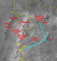
Today's move was about 6.5m ENE, according to the tracking web info, and here's the latest navcam mosaic. I don't know if they still plan to stop or pass by the sites 7 and 8 pointed on the official route map (http://marsrovers.jpl.nasa.gov/mission/tm-spirit/images/MERA_A1376_4_br2.jpg), but just in case I've circled them on the mosaic.
|
|
Posted by: Astro0 Dec 3 2007, 10:04 PM
Short of having a 'Sarlac' at the bottom, Tartarus was a close call for our little Spirit.

|
Astro0
Posted by: Tesheiner Dec 4 2007, 11:55 AM
I was updating my Spirit's route map to include the so called "WH3 - Winter Haven #3" on the map, and seaching for it on older images I found that Alan already posted some ones http://www.unmannedspaceflight.com/index.php?s=&showtopic=4752&view=findpost&p=104097 on this same thread. I looked for the navcams taken during sols 766 and 767, which are the closest ones to the planned WH3, and stitched this mosaic below.
|
|
Now, each time I look to this picture I ask myself: "where will Spirit be parked?"
Correct me if I´m wrong but I see this place as another sand trap.
Posted by: alan Dec 4 2007, 12:58 PM
The drifts I see are on a fairly steep slope. Traversing them going down the slope, I assume they will avoid the rocks by driving towards the 767 position, shouldn't be too much of a problem. The problems the rovers have had so far with sand traps have occurred when going upslope.
Posted by: Tesheiner Dec 4 2007, 04:50 PM
The problem I see is that those drifts look to be of "fluffy" sand deposited by wind, meaning that it would be very easy to loose traction on the back wheels due to dragging the broken one, even on a downslope. Off course, it's just an opinion.
----------
On another topic, today (sol 1393) was planned as driving sol however the downlinked pictures show no movement at all (site/drive counters are still the same as yestersol).
Posted by: hortonheardawho Dec 4 2007, 10:29 PM
SFX of Spirit at WH3:
http://www.flickr.com/photos/hortonheardawho/2086773077/
with link to sol 766 RAD panorama.
This is my best guess. Spirit will back down the slope? Maybe stop a little higher up the slope to get more tilt?
I'm sure the SFX gurus ( guruae?) can create a better image, but I thought I would try -- since, as Tesheiner pointed out, there was no movement tosol.
Posted by: abalone Dec 5 2007, 04:51 AM
http://www.flickr.com/photos/hortonheardawho/2086773077/
with link to sol 766 RAD panorama.
This is my best guess. Spirit will back down the slope? Maybe stop a little higher up the slope to get more tilt?
I'm sure the SFX gurus ( guruae?) can create a better image, but I thought I would try -- since, as Tesheiner pointed out, there was no movement tosol.
If might be better to go sideways with the lame wheel on the high side, that would take a lot of weight off it and put more weight on the three good down slope wheels. That would give the option of moving in both directions to maneuver into a favorable position. If they got straight down the slope there will be no going back once they are committed.
Posted by: brellis Dec 5 2007, 05:16 AM
Forgive me if this was discussed elsewhere:
Have they considered running a wheel up on one of the rocks to tilt the panels even more? Maybe that would knock some more dust off too.
Posted by: Astro0 Dec 5 2007, 05:56 AM
Quote: "I'm sure the SFX gurus ( guruae?) can create a better image..."
Only if we can get the new version of the Rover model you are using.
Is this another of Doug's creations or something new.
I recall that the last one was posted somewhere on UMSF.
Could we pleeeease have the latest version? Pleeeeease.
Astro0
Posted by: djellison Dec 5 2007, 08:22 AM
I assume they'll be backing down the slope. Once they're on it - there's no way they'll be able to drive back up again. If I pick up, rattle, drop and shake my TV around - the dust on the screen wont move
Doug
Posted by: centsworth_II Dec 5 2007, 09:52 AM
And, although the rovers have been jostled on occasion, there has not been a
cleaning event associated with any of the accidental bumps, so there is little
chance of a purposeful bump causing a cleaning event.
Posted by: Tesheiner Dec 5 2007, 04:04 PM
Driving activity during sol 1394 succeeded, with Spirit moving right to "Site 7".
Here's the latest navcam mosaic.
|
|
Site 7 are those rocks spread near the rover's right wing on the leftmost frame and site 8 is that "big" rock on the background behind site 7.
Posted by: fredk Dec 5 2007, 05:58 PM
Abalone raises a good point - when you're parked on a slope, the point on the ground below the centre of mass is downslope of the centre wheels, so the farthest upslope wheels take the least weight. So you really should have the lame wheel at the top (plus that's the way they normally drive, lame wheel trailing, for stability).
In fact, if the slope is steep enough the topmost wheels would have so little weight on them that they wouldn't contribute much to driving, so I wonder if they might actually be able to drive back up the slope in the spring. I'm sure an engineer could plug in some numbers and see if this holds up.
Posted by: hortonheardawho Dec 5 2007, 08:10 PM
Is this another of Doug's creations or something new.
I recall that the last one was posted somewhere on UMSF.
Could we pleeeease have the latest version?
Pleeeeease.Astro0
I created the rover image using this http://mer3d.free.fr/3d/mer3dInstrumentation.php by eyeballing the orientation I wanted, did a print screen, pasted the image to Paint, saved and then loaded it into imagej, converted to B&W, did a polygonal select, copied, positioned and pasted the selected image to the base image.
It would be nice if the interface had a numerical input option to select lens, distance and orientation. Then a "real" 3D SFX image could be created.
And, yes, the best way to maneuver Spirit is sideways, but what would be the best orientation for maximum sunlight? My guess shows the mast shadow fall mostly on the front of the vehicle.
Posted by: djellison Dec 5 2007, 08:43 PM
I would back down, as then the PCMA shadow would be mainly over the front of the vehicle, not the arrays.
Doug
Posted by: tty Dec 5 2007, 09:06 PM
Actually with a dud wheel there is no way Spirit is going back up a 30 degree slope. Whatever happens it will have to leave downslope. So you had better not park above a sand trap.
Posted by: Astro0 Dec 5 2007, 10:23 PM

|
Astro0
Posted by: climber Dec 5 2007, 10:48 PM
Astro0
Astro,
Once, I watched the rover drivers on a TV chanel and I saw that they use "lines references" on their computer's screen. What is strange here is that the "line references" is on the Earth image !
Nice idea anyway
Posted by: abalone Dec 5 2007, 10:52 PM
If the rover is sideways on a 30 deg slope then they can choose the angle of attack to get up the incline, it could be as little as a few deg. Thats how they got out of Endurance crater right at the beginning of the mission. If they go straight over then if they dont get it right the first time there will not be much chance for adjustment
Posted by: mhoward Dec 6 2007, 02:01 AM
A look back at "Tartarus":
http://flickr.com/photo_zoom.gne?id=2089594735&size=l
Posted by: BrianL Dec 6 2007, 04:38 AM
Wow, that really demonstrates the old adage that hindsight is always 20/20. Tartarus from this perspective looks like a place to not be.
Brian
Posted by: CosmicRocker Dec 6 2007, 04:57 AM
I am still trying to understand the interest in sites 7 and 8. Is Spirit's miniTES still working?
I am not convinced they will approach WH3 from the top.
Posted by: fredk Dec 6 2007, 05:39 AM
I thought I read that sites 7 and 8 were to be used for imaging the surroundings, since they are a bit higher than most of HP.
Why do you think they may not approach from the top? There's only 2 weeks left, and after the scare of Tartarus, I'd think they'd want to play it safe.
Posted by: Aussie Dec 6 2007, 08:11 AM
[quote name='mhoward' date='Dec 6 2007, 02:01 AM' post='105130']
A look back at "Tartarus":
The incident makes sense to me now. The drive was meant to bypass Tartarus (though a bit closer for comfort regardless) and you can see the point where a rock snagged the dead wheel and caused a course change to the left. No anomalous input from other wheels that would have resulted in an abort.
Posted by: djellison Dec 6 2007, 08:27 AM
Convinced or not, there's no way in hell they're getting 25 degrees from the bottom in the next two weeks - so from the top is the route.
Doug
Posted by: fredk Dec 6 2007, 04:15 PM
They've been pretty close to the edge of HP at times - could a course diversion like this have sent them over the edge? Are checks on rover orientation being made during drives?
Posted by: djellison Dec 6 2007, 06:17 PM
Over the edge would get picked up by tilt limits. The dive into Tartarus must have been under the limits
Doug
Posted by: fredk Dec 6 2007, 09:04 PM
http://marsrovers.jpl.nasa.gov/mission/tm-spirit/spirit-sol1391.html
That new map also names the two big rocks at site 8 "pair of plums"
Posted by: climber Dec 6 2007, 09:46 PM
Doug
Interesting to note that by even staying under the limits, the rover can be traped anyway.
Now, imagine that the whole rover drive above a "big" rock until the RFW get to this rock. If it's a loose rock and if it follows exactely the direction of the drive, nobody would realise for a while that the rock is where it is. This should not happen since we know where we go but, in a Tartarus like situation, who knows? So, my question is : we know we can drag the dead RFW, we know we can pivot around it but can we push it to get free from the above situation?
A bit
Posted by: Aussie Dec 7 2007, 03:23 AM
I wouldn't like to second guess the drivers from the comfort of an armchair, but I think that the Tartarus incident gives us some clear operating constraints. If they go in from the top then as the vehicle attacks the slope we will end up with four wheels on the slope and the trailing pair, including the broken wheel, in midair. If the rover stopped in this position and did not go slip sliding away then when comes the time to leave there would seem no impediment to climbing out forward as the dead wheel will not impede progress while the vehicle is climbing, and maximum weight and thus friction would be on the lower wheels. Driving out downward trailing the broken wheel would also present few problems.
Going in from the bottom means tackling what appears to be a 'fluffy' depositional surface in the WH3 lower approaches although if this presents no problems then climbing the slope should present no problems until the dead wheel reached the slope. But climbing out would be out of the question since we would, as at Tartarus, end up with two driving wheels in midair and the vehicle stuck. Pushing a dead wheel down into the surface trying to drive out downwards would be an interesting experience. On balance I plumb for backing down the slope at WH3 and leaving the trailing wheels suspended. since we would have to go down the slope somewhere in order to go up at WH3, doing this evolution once only at WH3 makes good applied common sense.
Posted by: CosmicRocker Dec 7 2007, 05:22 AM
Why do you think they may not approach from the top? There's only 2 weeks left, and after the scare of Tartarus, I'd think they'd want to play it safe.
I didn't expect my statement doubting a top-down approach to be so controversial. I can imagine various advantages and difficulties with both the top-down and bottom-up approaches. I favor the bottom up approach because:
- I am not certain that the site having the best science targets will be approachable from the top,
- There are two WH3 sites currently under consideration, and I suspect additional, local reconnaissance may be in order,
- While Spirit is probably not capable of climbing over Husband Hill again, I am pretty confident that the rover handlers can handily drive Spirit up a 25 degree incline in many places around the periphery of HP.
- Although 2 weeks is the recently stated goal, Spirit has a bit more time than that to slide into her next winter haven.
Posted by: djellison Dec 7 2007, 08:31 AM
They've said that they can manage 8 degrees with the FRW stuck. If they drive off, and can't get up from the bottom (which is almost certainly true) - then they've got to drive all the way around to the east side to get back on top. Driving off the top to try and drive up a 25 degree slope from the bottom would be virtual suicide.
Doug
Posted by: BrianL Dec 7 2007, 11:04 PM
Given the veer off to the East in the last couple of drives, assuming this isn't just circumventing an area that they thought might be troublesome between 1394 and WH3, my best guess is that they are planning to circle back and approach WH3 at an angle instead of straight over the edge. Similar to what Oppy did to exit Eagle when the straight out approach didn't work. This would also make for a much easier egress, but of course not knowing the topography, this is all speculation.
Brian
Posted by: fredk Dec 7 2007, 11:26 PM
I'm puzzled by this move to the east too. I don't think it's about angle of attack to the slope at WH3, since the surface of HP is pretty flat up to the edge, so they could've driven directly to the edge of HP from 1394 and then turned to take the slope at an angle if they wanted. Anyway, I'd think they'd want to do some imaging of the edge to find the best WH3 site before going over the edge, so I was expecting a drive along the north edge first, much closer to the edge than they are now.
Perhaps they didn't like the look of the surface between the 1394 site and the edge, as you said. Maybe it's Fuzzy Smith, as someone said in the route map thread. But there's really not much time to do science now, and if they were keen on Fuzzy why didn't they study it when they first reentered HP three months ago? I think we'll have a better idea with the next drive.
Posted by: climber Dec 8 2007, 12:26 AM
We're driving no more than 15 meters from the edge of NP so, we're at 1-2 sols of the closest North facing slope. That's a pretty safe situation to continue "wandering around" for another week and take time to select the best spot or get to the closest if needed.
Posted by: CosmicRocker Dec 8 2007, 05:37 AM
I agree, climber. I think if we watch for one or two more sols, we should better understand the plan.
Posted by: climber Dec 8 2007, 10:42 AM
I'm may be pushing the limits here, but here's a plan for this winter.
Last winter we basicaly did a MEGA pancam picture so, let's shoot for a MEGA microscopic picture this winter. The North facing slope of HP will be ideal for this since it is realy a North facing (and quite regular) slope for several meters. We're heading now to the East of the area so we could start there and go to the West during the 8 months of wintering and cover a large and wide surface (1 x 20 m).
Ok, I know the objection : we'll be in a survival mode instead of a science mode. Nevertheless, I'll be currious to know if this plan is totaly unreasonable of if we could have a chance to run it regarding the available energy. Basicaly we need to operate the arm, take pictures and transmit them. Then, once in a while, to rove to next position. Any figures (other than NO, Nope, No way...) ?
Posted by: djellison Dec 8 2007, 11:48 AM
Well - you're asking to traverse across a 25 deg slope - with 5 wheel drive. I don't think that's particularly wise. The chance for slippage OFF the slope would be significant. Even dropping from 25 to 15 degrees might be that slight extra challenge on the shortest days that Spirit might not survive.
I've got not problems at all with a significant and extensive MI survey within the IDD work volume (it'd be fantatsic) - if they can park up in an appropriate place at the start of winter where the slope is at its very best - and that site includes the sort of interesting rock that we saw on the north rim of home plate back in the mid 700's.
We've got a very thin piece of winter haven here - and to tread along it any more than is needed would be an unnecessary risk.
Doug
Posted by: fredk Dec 8 2007, 04:01 PM
Actually I think it would be feasible to do an intensive arm study of a work-volume-width strip down the slope. As you drive over the edge, your tilt will increase from zero to the max (30 degrees?) and then back towards zero as you reach the bottom. We won't need the maximum tilt immediately (we're surviving now with zero tilt, after all), so you could start by driving just a bit over the edge, studying the heck out of the work volume, then as power drops you drive 30 cm (or whatever) further down to get a better tilt, study the new work volume, etc. You'd have the strongest tilt when the solar illumination is lowest, and probably do no moving or science for a long period. Then as spring approaches you move down again and examine the lowest parts of the slope.
I can't see that occasional 30cm drives downslope would require much power. Then again, they may prefer to play it safe and drive to the maximum tilt immediately.
Posted by: centsworth_II Dec 8 2007, 04:27 PM
It's taking too much of a chance to assume you will be able
to maneuver to get the slope you want when you want it.
Surely IMO what they will do, is to get into the best position
ASAP after going over the edge, and stay put!
Posted by: Shaka Dec 8 2007, 07:05 PM
http://qt.exploratorium.edu/mars/spirit/rear_hazcam/2007-12-08/2R250389738EFFAW4ZP1312L0M1.JPG
(Overheard in machine language over DSN: Spirit: Hey Ma! Look at ME! Hee Hee!
Mrs Jay Peeyell: Get away from that edge, you silly fool! You'll break your IDD!
Posted by: jvandriel Dec 8 2007, 07:06 PM
The view in the drive direction on Sol 1395.
Taken with the R0 Navcam.
jvandriel

|
Posted by: mhoward Dec 8 2007, 07:14 PM
Yep, here we are:
http://www.flickr.com/photo_zoom.gne?id=2095330507&size=l
The drifts below look non-threatening to me, at least from this perspective.
Posted by: Shaka Dec 8 2007, 07:31 PM
The trick is to not go down as far as the drifts, but I assume we are somewhat east of our haven. Tesh?
Can anyone see our tracks from last year?
Posted by: mhoward Dec 8 2007, 07:36 PM
"Well, duh." I was looking ahead to when Spirit gets to finally drive away, many months from now.
Posted by: Stu Dec 8 2007, 09:34 PM
Interesting spot...
[attachment=12822:pano.jpg]

|

|
Posted by: CosmicRocker Dec 9 2007, 02:13 AM
Ok, I guess I am a believer in the top-down theory, now.
Shaka: I think Spirit is just a bit east of WH3. That black basalt boulder in the images just to the right of Spirit (see mhoward's pano above) is likely to be the black spot on Tesh's route map, right between WH3 and Effa Manley. I've spent a good deal of time trying to identify tracks. There should be plenty of tracks right off from here, but I can't say I saw anything that was very convincing.
Posted by: Tesheiner Dec 9 2007, 08:29 AM
Yup. Spirit is just inbetween WH3 and Effa Manley.
Posted by: djellison Dec 9 2007, 09:37 AM
There are some feint tracks visible - but given the fairly dynamic summer the atmosphere has had, I don't expect them to be particularly obvious.
Doug
Posted by: Stu Dec 9 2007, 10:46 AM
Another one to make you wish you could just rake your gloved fingers through the dirt here and feel the grit...

|
... and while I'm here, anyone out there who can tell me what the dark marks are on the top of Spirit here? Just curious... accumulated dust..?

|
Posted by: djellison Dec 9 2007, 11:00 AM
Yup - there's raised wiring in those places, so dust will accumulate.
Doug
Posted by: jvandriel Dec 9 2007, 03:41 PM
Here is the 360 degree panoramic view taken
on Sol 1395 and Sol 1396 with the L0 Navcam.
jvandriel
|
|
Posted by: fredk Dec 9 2007, 05:27 PM
The tracks around the 759 site on top of HP were much easier to see than those down below us now. Probably all the dust down there helped to cover up those more than the ones on top.
I've been a bit baffled about the dark marks that Stu points out - if there were more dust near the raised wires, I'd expect those areas to appear lighter instead of darker. The panels would look dark in areas where the dust was removed. It might be that turbulence near the raised wires etc helps to clear away the dust in those areas.
Posted by: djellison Dec 9 2007, 06:26 PM
The dark patches are all around the complex wiring - compare to http://pancam.astro.cornell.edu/pancam_instrument/adeck3.html
We've all tried to guesstimate at various deposition, erosion, and to be honest, it's all been a bunch of utter nonsense almost without exception - but it's clear that where there are wires there are dark patches (or dark patches that have been streaked).
Doug
Posted by: hortonheardawho Dec 9 2007, 07:30 PM
sol 1387 L456/R1234567:
http://www.flickr.com/photos/hortonheardawho/2098654970/
with link to 1398 Navcam view.
It is not unreasonable to infer that the dark areas in the Navcam view is similar to the dark areas in the pancam view.
Er, what's with that dark circular patch at the base of the red color chip? There is a hint of a similar dark circle below the green chip too.
Note also that the dust on the sundial and magnet appears to be the fine "red" dust from the storm. The dark dust -- especially the really dark dust near the color chips -- is what and from where?
Posted by: djellison Dec 9 2007, 07:54 PM
There are hints of a discolouration on all four of the corners of the SD from very early on, on both vehicles. What causes it - don't know - perhaps something to do with the rover build process.
As for different colours of dust - one need only consider the strength of the wind we've seen in the past year because of the dust storm, the different colours of soil we've seen by digging around a bit and the variety of colour as close as El Dorado.
Posted by: mhoward Dec 9 2007, 09:21 PM
http://www.flickr.com/photo_zoom.gne?id=2098981606&size=l
Posted by: fredk Dec 9 2007, 09:27 PM
Does anyone know how the sundials are attached? This is all speculation, but perhaps the surface near the corners was altered in some way or coated with something before installing the dials, and maybe the dust doesn't stick as well there.
But I think the simplest explanation for this (and all the dark areas) is removal of dust by wind. There could be little wind vortices at the corners.
I'm sure Doug is absolutely thrilled at the prospect of another fascinating and vigorous debate on these dark areas: clean sweep or depositional!
Posted by: Tesheiner Dec 9 2007, 10:04 PM
Have a look to the http://qt.exploratorium.edu/mars/spirit/navcam/2007-12-09/, from sol 1398, and the direction of the drive on that sol.
It's just me or does anybody else thinks that they are looking to "Effa Manley" as a possible winter haven?
Posted by: Aussie Dec 9 2007, 10:30 PM
It's just me or does anybody else thinks that they are looking to "Effa Manley" as a possible winter haven?
I would be very surprised if they haven't been studying the northern slopes over the past few weeks and refining their winter haven target. The fact that they designated two possible locations (WH3a & b ) indicates that nothing was certain other than the general location. From Mhowards graphic they are right on the edge now. Could it be that this is their final destination?
Posted by: Shaka Dec 10 2007, 01:02 AM
They haven't even examined the original WH3s up close yet. They came straight over to the east side. I'm betting it's to have a decko at Fuzzy, then shoot through like a Bondi tram to the west side.
Their haven deadline is still 10 days away.
Posted by: Floyd Dec 10 2007, 01:23 AM
Could someone remind me as to which rock or outcrop is "Effa Manley"?
Posted by: Phil Stooke Dec 10 2007, 04:35 AM
"then shoot through like a Bondi tram to the west side. "
They'll be there by Sparrow Fart.
Phil
Posted by: alan Dec 10 2007, 06:03 AM
I don't remember if Effa Manley referred to a specific rock or a larger outcrop.
Estimated location from sol 742:
|
|
Navcams of the area:
http://marsrovers.jpl.nasa.gov/gallery/all/2/n/767/2N194463873EFFAPA0P0685R0M1.HTML
http://marsrovers.jpl.nasa.gov/gallery/all/2/n/767/2N194464041EFFAPA0P0685R0M1.HTML
http://marsrovers.jpl.nasa.gov/gallery/all/2/n/767/2N194464218EFFAPA0P0685R0M1.HTML
Posted by: CosmicRocker Dec 10 2007, 06:12 AM
Floyd: Look to Teheiner's route map to find the location of Effa Manley, and other natural wonders.
It's just me or does anybody else thinks that they are looking to "Effa Manley" as a possible winter haven?
Prior to Tartarus it seemed they were heading toward the first ramp onto HP near Gibson, on the NW side. I was guessing they wanted to use it as an off-ramp. The 3D HiRise imagery suggests other Tartarus-like depressions in that corner of HP. To avoid those potential pitfalls, I now suspect they may be heading for the second HP on-ramp which they used on sol 768. Either one of these locations would serve as a site from which to dismount HP.
Posted by: Astro0 Dec 10 2007, 06:30 AM
Polar projection from jvandriel's panorama from Sol 1395-1396.
With Spirit added.

|
Astro0
Posted by: Tesheiner Dec 10 2007, 09:27 AM
Floyd: Could someone remind me as to which rock or outcrop is "Effa Manley"?
Alan: I don't remember if Effa Manley referred to a specific rock or a larger outcrop.
Here are the pancam imaging sequences named after Effa Manley:
767 p2371.15 8 0 0 8 2 18 pancam_Effa_Manley_Part1_add_L257R1
767 p2372.15 20 0 0 20 2 42 pancam_Effa_Manley_Part2_L257R1
768 p2374.15 20 0 0 20 2 42 pancam_Effa_Manley_Part3_L257R1
And here the links to the pancam images on the MER webpage: http://marsrovers.jpl.nasa.gov/gallery/all/spirit_p767.html, http://marsrovers.jpl.nasa.gov/gallery/all/spirit_p768.html.
I was checking again the pictures and now I'm not really sure if my route map is correctly labelled. It looks like "Effa Manley" refers to the whole area between the 766 and 767 positions.
Posted by: Floyd Dec 10 2007, 05:10 PM
Thanks Tesheiner and alan, I didn't think it was a particular rock (like Fuzzy Smith). And CR, I do look at Tesheiner's route maps
Posted by: fredk Dec 10 2007, 06:23 PM
There was another short move eastwards on sol 1399. It looks like they're studying the edge to find the best spot to park.
Posted by: Stu Dec 10 2007, 08:28 PM
Don't know about anyone else, but I can almost smell the dirt looking at this...

|
Posted by: djellison Dec 10 2007, 08:37 PM
damn sharp view isn't it - lovely stuff
Doug
Posted by: stevesliva Dec 10 2007, 08:54 PM
Smells like rust? Sulfur? Salt? Who needs a mini-TES when we can send a human nose there to sample all those aerosolized minerals? Maybe we can have the next rovers lick the rocks, too... akin to the viking experiments. Lick it and see what happens. (Good planetary radio question... what does mars smell like. What did they say the moon smelled like?)
Posted by: Del Palmer Dec 10 2007, 10:44 PM
Gene Cernan said Moondust smelled like burnt gunpowder. Jim Garvin has said that Mars would have a similar odor to volcanic areas on Earth (sulfur-rich).
Posted by: dot.dk Dec 10 2007, 11:40 PM
Can someone refresh my memory on how long we will likely be at the winter haven?
As it is now we are at early SH autum. Just passed the equinox actually according to Mars 24.
If we need to stay here from Christmas onwards, would that mean we will stay to the next spring equinox?? That's a mighty long time
Can always hope for some  cleaning.
Posted by: climber Dec 11 2007, 12:16 AM
I guess we'll be there for some 8 months... as long as last winter and probably more life threatening
Posted by: nprev Dec 11 2007, 02:19 AM
Great pic, Stu!!!
Did anybody else notice that quite cubical rock in the lower right section? Seems to be sitting on a nice flat plate-like rock as well. Almost have to wonder if it's a dust-encrusted crystal of some sort (pyrite?)
Re smell of Mars: The soil mix I made based on Viking results for a science fair project way back in the Pleistocene (using sulfates for the major minerals) did have a very distinct sulfurous odor. Unlike the Moon, I think that future Martian farming will have to be entirely hydroponic...even if plants would grow in that stuff, I'm sure they'd taste pretty nasty.
Posted by: Aussie Dec 11 2007, 03:27 AM
Back in the lab on Earth the dust collected by Apollo Missions had no discernable smell. Must have been a short term reaction (nice oxygen rich and damp environment in the capsule). Nprev - did you try to grow anything in your science project mix? The Martian dirt would make Acid Sulphate Soils seem positively alkaline.
Posted by: hendric Dec 11 2007, 05:30 AM
Doug
I think it's the other way around, the raised wiring is causing turbulence, making the dust not "stick" to those areas. At least, that's the way it looks to me.
Posted by: alan Dec 11 2007, 06:03 AM
a bunch of press release images posted by JPL including an image of the panels, dark patches next to the wires included.
http://marsrovers.nasa.gov/gallery/press/spirit/20071210a.html
Posted by: dvandorn Dec 11 2007, 06:21 AM
Moon dust smelled like burned gunpowder to the astronauts, so the story goes, because the dust had sharp rock facets that had never been exposed to enough gas to interact with the facet surfaces. That made the surfaces of the dust particles slightly more chemically reactive than they would become once they had been immersed in gases for a bit. (Especially oxygen.) Gunpowder is also more chemically reactive than most other terrestrial substances (certainly more than dirt), and so our sense of smell perceives the two substances similarly. As soon as Moon dust is kept in an atmosphere for a while, it loses its odor.
Now, as for Mars... I have been thinking for some time that Mars dust might actually have a rather nauseating aroma. Add the obvious sulphuric element to the peroxides that are postulated to make up at least some of the soils, and you get something that would stink and burn your nasal passages, all at once. It would be a hell of a note if we lost the first humans on Mars because they couldn't keep food down...
-the other Doug
Posted by: imipak Dec 11 2007, 06:36 AM
Interesting http://news.bbc.co.uk/1/hi/sci/tech/7137793.stm concerning discoveries in "churned up soil" (is that Tyrone they're talking about?)
The other idea being pursued by the rover team is that they have stumbled across a fumarole, where acidic steam rises through cracks in rocks and strips them of all of their mineral components, apart from silica.
(single sentence BBC paragraphs compressed.)
Posted by: djellison Dec 11 2007, 09:41 AM
You know something, comparing to the area around the based of the PCMA etc - I think you're right.
The only issue there though, is that the wires right along the first cell to the right of the calib target should be white if clean, and where the deck is brown - they're whitey brown - where the deck is black ( suggestive of clean by this thinking ) the wires are black.
Doug
Posted by: nprev Dec 11 2007, 01:14 PM
Yeah...a couple of unfortunate cacti & succulents. Had a nice red rock with lichen in there as well. I filled the container with CO2 & pumped it down to something less than 50 mb (as best as I could tell with my school's equipment); did not simulate the temp swings, did not simulate the UV flux. Despite the fact that this made the environment Miami Beach compared to the real Mars, the plants croaked pretty fast...around two weeks, and they became dryed-up shriveled things. Saw no ill effects on the lichen, though.
Posted by: JRehling Dec 11 2007, 07:04 PM
[churned up terrain]
For good or bad, the SF daily paper (the AGU is meeting in San Francisco) is fronting this story in a way reminiscent of the 1996 story about microbes in martian meteorites: "The Biggest Mars Find Yet", with a link to a story similar to the BBC article but more optimistic about astrobiological ramifications:
http://www.sfgate.com/cgi-bin/article.cgi?f=/c/a/2007/12/11/MN4OTRSU8.DTL
This sentence (from the Chronicle Science Editor?) strikes a tone that I didn't find in Squyres's comments or the BBC article: "This may turn out to be the best evidence yet that living organisms could once have existed on Mars and left their fossilized environments of silica and titanium traces as testimony."
That sentence alone seems to imply that the silica and titanium are actually caused by organisms, whereas in reading Squyers's comments themselves, I infer that silica and titanium HAPPEN to be found in environments on Earth with microorganisms (like just about every place on Earth), but not linking the two.
Anyway, if the Columbia Hills are lots of piled up impact debris sitting in a crater, it's interesting if anything geyserlike reached up through them at all. As for astrobiology, I don't see any connections. Earth is covered with biota, and some have adapted themselves to geysers. That hardly means that geysers would be a place where life could arise.
Posted by: hendric Dec 11 2007, 08:13 PM
Doug
Well, the wires and the deck are made of different materials.
Maybe the wires are covered in dust because, being insulators, they can hold a static charge better and so attract dirt like the front of an old CRT. Maybe some of the wires are carrying more current than others, building a stronger magnetic field and attracting more iron dust? Or maybe 3 years on the harsh Martian environment is causing the insulation to turn?
Posted by: ElkGroveDan Dec 11 2007, 08:15 PM
Also from the S.F. Chronicle story:
The undamaged Opportunity, which has traveled about seven miles since it landed, is now well down inside the large crater named Victoria, where its instruments are busy analyzing three layers of white rock that its Earth-bound science controllers have nicknamed the "bathtub ring." Those layers, hundreds of yards thick, are rich in sulfates that also may mark ancient wet conditions on the planet, Squyres said
Posted by: alan Dec 11 2007, 08:30 PM
|
|
Now, each time I look to this picture I ask myself: "where will Spirit be parked?"
Correct me if I´m wrong but I see this place as another sand trap.
Looking at it from this angle it does look hazardous, the drifts appear to extend onto a relatively flat step.
http://qt.exploratorium.edu/mars/spirit/navcam/2007-12-11/2N250651838EFFAW9DP1926R0M1.JPG
this slope looks nice though
http://qt.exploratorium.edu/mars/spirit/navcam/2007-12-11/2N250651910EFFAW9DP1926R0M1.JPG
Posted by: Stu Dec 11 2007, 10:13 PM
Get yer fingers in that dirt...

|
Posted by: Tesheiner Dec 12 2007, 10:56 AM
http://qt.exploratorium.edu/mars/spirit/navcam/2007-12-11/2N250651838EFFAW9DP1926R0M1.JPG
this slope looks nice though
http://qt.exploratorium.edu/mars/spirit/navcam/2007-12-11/2N250651910EFFAW9DP1926R0M1.JPG
I thought it would be nice to see Spirit's current location from another perspective.
Here's a picture combining the view from the current site (as of sol 1400) on top of HP and another one from the bottom, taken on sol 767. I tried to identify some rocks on both mosaics (1, 2, 3, and the group numbered 4) and some parts (A, B, and C) of the northern slope. The slope A is the one right in front of the rover.

|
OT: A Mars bar will be the prize for anyone able to find the old tracks between points 3 and 4. I couldn't.
Posted by: Tesheiner Dec 12 2007, 11:20 AM
On another topic, but still related to winter haven, here's an article from the OSU (Ohio State University).
http://researchnews.osu.edu/archive/wintersite.htm
The http://researchnews.osu.edu/archive/wintersitepix.htm is mostly centered on the path to Von Braun. I would really like to find a similar one for HP north.
Posted by: TheChemist Dec 12 2007, 11:37 AM
Thanks Tesh, this comparison helps a lot.
Slope A looks nice and navigable, but I am cautious about the lower wheels if Spirit is parked there.
Will there be enough rock underneath them ?
If the lower wheels sink in sand, getting out in spring might be difficult.
Not that we have any other options with winter approaching fast, of course ...
Posted by: john_s Dec 12 2007, 07:13 PM
The complete obliteration of the old tracks here is remarkable- it's rather humbling that our mark on this corner of Mars was so short-lived. But wouldn't it be nice if it was a sign that winds tend to be funnelled through this trough, and that we might therefore hope for some cleaning here?
Posted by: djellison Dec 12 2007, 07:50 PM
I was thinking exactly the same thing - there's a bit of evidence of winds on this site - the little dune at the bottom, the exposed rocks....Spirit might get some good treatment here...fingers crossed
Doug
Posted by: peter59 Dec 12 2007, 08:15 PM
I hope that Spirit's tilt at WH3 ( about 30 degrees) may help to clean solar panels by faint wind.
Posted by: mhoward Dec 12 2007, 08:49 PM
Amen to that. I wonder if there is also a temperature advantage in parking over a nice large exposed rock face here, as opposed to parking over sand-covered rock somewhere else.
Posted by: jvandriel Dec 12 2007, 09:26 PM
North Side of Home Plate.
The panoramic view taken on Sol 1398 with the R0 Navcam.
jvandriel
|
|
Posted by: Stu Dec 12 2007, 10:54 PM
Small colour section...

|
Posted by: Julius Dec 13 2007, 02:00 PM
The high silica content detected by Spirit seems to be the result of geyser or fumarole activity in the past:thats the official interpretation of this finding.
I've read in some papers discussing atmospheric evolution on Mars as to a process where CO2 interacting with CASIO3 on the surface would also produce SIO2 and CACO3.However since martian carbonates have not been detected up to now,scientists have been reluctant to give such process much importance.
Could the present absence of carbonates justify to rule out this process as the source of SI02 in Gusev!?What other evidence would favour geyser/fumarole activity rather than CASI03 as a source for the high silica content of home plate soil?
Posted by: Stu Dec 13 2007, 05:26 PM
Bit more...

|
Posted by: climber Dec 13 2007, 07:06 PM
It's gona be though to find exactely the rigth place with the rigth angle. I'm happy we're already where we are because I guess it'll take several sols before weels stop. Fortunately angle will compensate for solar power decay.
Posted by: dburt Dec 13 2007, 10:19 PM
CaSiO3 is the mineral wollastonite, which forms via contact metamorphism of siliceous limestones, not via crystallization of basaltic lavas. Not surprisingly, spectral data show no such mineral on Mars (AFAIK), although I'm not sure anyone is looking very hard for it - it wouldn't be expected, without limestones. The high silica content of the soil in "silica valley" (stratigraphically beneath the Home Plate rocks, apparently - therefore older than Home Plate proper and not necessarily a part of it) remains a mystery. High-silica alteration is typical of silica-rich volcanic systems, such as Yellowstone Park, and is rare or absent in low-silica basaltic systems, such as Hawaii. The Home Plate system is presumed to be volcanic based mainly on its basaltic composition. No volcano is evident, and no lava flows either. If the silica-rich soils result from alteration by a hot spring or fumarolic system, that system could just as easily be related to impact cratering and impact melting as to volcanism. All you need is a local buried heat source interacting with groundwater (including melted ice). Boiling of the hot water (which would happen at quite low temperatures on Mars) releases acids which alter (leach the basic oxides such as MgO and CaO out of) the rock, leaving silica (commonly with alumina). In hot water, silica can also be dissolved and reprecipitated at a distance. Alteration of glasses is faster and easier than alteration of crystalline lavas. Hope this sheds some light.
-- HDP Don
Posted by: jamescanvin Dec 14 2007, 06:35 PM
Looking for a nice spot...
http://www.canvin.streamlinenettrial.co.uk/mer/index.html#A1401
This links to a copy of my website hosted commercially. At the moment I'm on a free trial, so if anybody has any problems/comments with the hosting then I'd love to know before I hand any money over to these folks.
James
Posted by: Tesheiner Dec 15 2007, 03:01 PM
This rhazcam picture was taken after driving on sol 1403 (yesterday).
I think we are one or two sols ahead of the Day-D, when Spirit should start moving down the slope.
http://qt.exploratorium.edu/mars/spirit/rear_hazcam/2007-12-14/2R250918345EFFAW%23%23P1314R0M1.JPG
Stay tuned...

Posted by: mhoward Dec 15 2007, 04:51 PM
Agreed. Here's a quick http://www.youtube.com/watch?v=b4Qa0TvfvWs, and a couple views:
http://www.flickr.com/photo_zoom.gne?id=2112410337&size=l http://www.flickr.com/photo_zoom.gne?id=2112350777&context=photostream&size=l
Posted by: CosmicRocker Dec 15 2007, 05:30 PM
That seems to be what http://marsrovers.jpl.nasa.gov/mission/status_spiritAll.html#sol1390 is indicating.
Posted by: peter59 Dec 15 2007, 10:04 PM
Ready to go ?

|

|
Posted by: Shaka Dec 15 2007, 10:19 PM
Things must be really urgent, if they're taking the plunge here, without even checking out the WH3 sites to the west.
OK, Spirit,...Geronimo!!
Posted by: ngunn Dec 16 2007, 12:00 AM
Who's plunge is it this time? Do we know? Yours again Paolo???
Posted by: Aussie Dec 16 2007, 03:28 AM
I kinda like Shaka's 'Geronimo Plunge'.
Posted by: Tesheiner Dec 17 2007, 09:08 AM
The plunge has started!
http://nasa.exploratorium.edu/mars/spirit/rear_hazcam/2007-12-15/2R251007216EFFAW%23%23P1314R0M1.JPG Sol 1404 => Sol 1405 http://nasa.exploratorium.edu/mars/spirit/rear_hazcam/2007-12-16/2R251097011EFFAW%23%23P1314R0M1.JPG


Posted by: djellison Dec 17 2007, 09:57 AM
From there
http://qt.exploratorium.edu/mars/spirit/rear_hazcam/2007-12-15/2R251006271EFFAW%23%23P1302L0M1.JPG
to there
http://qt.exploratorium.edu/mars/spirit/rear_hazcam/2007-12-16/2R251097011EFFAW%23%23P1314L0M1.JPG
I make it 6.1ish degrees of tilt.
(52 of 1024 pixels covering 120 degrees)
Of note - we're going down backwards. I presume this is because it's more controlled to decend with the broken wheel trailing, and the PCMA will not shadow across the whole array
Doug
Posted by: Tesheiner Dec 17 2007, 11:03 AM
I've got 5º, (45 pix. measuring from the deck to the horizon at Husband Hill). Anyway such a difference is irrelevant (for discussing).
What I really want to know is how it translates to an absolute tilt, because Spirit was not really levelled the last sols.
> Of note - we're going down backwards. I presume this is because it's more controlled to decend with the broken wheel trailing, and the PCMA will not shadow across the whole array
Agree.
Posted by: alan Dec 18 2007, 01:41 AM
Driving onto the edge has disturbed some of the dust.
http://qt.exploratorium.edu/mars/spirit/pancam/2007-12-17/2P250913926ESFAW%23%23P2850L5M1.JPG
Posted by: BrianL Dec 18 2007, 04:19 AM
Maybe a little wiggle dance on the slope is all she'll need to shake it off.
Brian
Posted by: brellis Dec 18 2007, 04:52 AM
Has that been attempted? I remember the iconic image of Sojourner with one wheel up on a rock. I've always wondered if that kind of driving would jog some dust off.
Posted by: djellison Dec 18 2007, 08:43 AM
We've discussed that about - ooo -18,000 times? The rover can't drive in any way that would be conducive to dust removal -it's not a sports car. Rockey terrain might cause some jarring that might shuffle some around - but there's no record in 1300 odd sols of operations whereby driving in any way has cleared dust. You need good strong winds.
Doug
Posted by: Tesheiner Dec 18 2007, 08:50 AM
Another move further down the slope.
http://nasa.exploratorium.edu/mars/spirit/rear_hazcam/2007-12-15/2R251007216EFFAW%23%23P1314R0M1.JPG Sol 1405 => Sol 1406 http://nasa.exploratorium.edu/mars/spirit/rear_hazcam/2007-12-17/2R251185026EFFAW%23%23P1314R0M1.JPG
Current relative tilt is about 15º, comparing to the attitude on sol 1404 (120 pix. difference, measured from the rover's deck to Haskin Ridge).
I'm still wondering / asking how to determine the absolute tilt. Ideas are welcome.


Posted by: djellison Dec 18 2007, 11:17 AM
Someone could figure out the solar elevation at X O'clock, at the time of a sundial image, and establish rover tilt through that. Otherwise, the only other tilt measurement is from the database which Mike pulls out for MMB.
Doug
Posted by: alan Dec 18 2007, 11:36 AM
Could we get a reasonable estimate from the angle of the horizon next time they do a 360 Navcam panorama?
Some news from JPL's latest update:
Posted by: ngunn Dec 18 2007, 12:39 PM
The degree markings on AndyG's endless pan could be used to find the elevation angle of horizon features. We haven't travelled too far from that spot. I'm linking to his whole post here for those who may have missed our obscure little endless panoramas thread. Please try out the panorama!
http://www.unmannedspaceflight.com/index.php?showtopic=4735&view=findpost&p=103348
Edit - Oops that's linked the whole thread. We want the panorama from post 11:
http://personal.strath.ac.uk/andrew.goddard/pan.html
Posted by: fredk Dec 18 2007, 11:55 PM
I'm still wondering / asking how to determine the absolute tilt. Ideas are welcome.
I get about 9 degrees of absolute tilt using the sol 1406 forward hazcam image. What I did was to look at several of the very early forward hazcams from near the lander, and assumed that the average visible horizon in those images was the true horizon. Then I counted pixels from that horizon position to my estimate of horizon in the 1406 forward hazcam (easier than the rear hazcam), and divided by 2.1 mrad/pixel.
I could easily be out by a few degrees if the plain near the lander was sloped by a few degrees. In fact, the front hazcams are supposed to be tilted 45 degrees downwards. Using that to fix the horizon, my measurement of 9 degrees becomes 12 degrees or so.
These numbers are probably consistent with yours, Tesheiner, since the top of HP is tilted southwards near the edge.
Posted by: mhoward Dec 19 2007, 01:38 AM
My measurement makes it about 15.3 degrees absolute tilt on Sol 1406. That's based on measuring from a visual rendering in MMB based on the tracking data. I could probably work out how to get the real number from the tracking data, but I'm worried that even the basic math to derive the angle from the rover orientation quaternion would probably make my head explode.
Posted by: Astro0 Dec 19 2007, 03:15 AM
WH3 Plunge.

|
Enjoy
Astro0
Posted by: BrianL Dec 19 2007, 03:32 AM
So, is that it? Have they reached all the tilt they are going to get at this location, or will further driving down the slope improve that?
Brian
Posted by: mhoward Dec 19 2007, 03:51 AM
I don't think that's it. The front and possibly even the mid wheels aren't over the edge yet, and according to Steve Squyres via the planetary.org rover update they're hoping for more like 25 degrees.
Posted by: Astro0 Dec 19 2007, 04:48 AM
I think that they'll try for another move forward (downslope) of about two or three more wheel diameters - somewhere near the red line. The forward wheels are just about over the edge of HP, certainly no more than a wheel diameter or two. Any more than that and they are on sandy ground and the tilt will surely decrease.
I hope that this gives them the 25 degrees (or near enough) that they are looking for.

|
Astro0
Posted by: Tesheiner Dec 19 2007, 08:53 AM
Well, yestersol (1407) was planned for driving and included a "post-drive" 360º navcam mosaic.
Images are down as usual, and I can see that a new "site" (AX00) was also declared.
I've checked the planned activities for sol 1408 too and no driving is expected to take place.
IMO, all this data are telling us that this will be Spirit's winter haven.
I'm a bit concerned about the tilt. http://nasa.exploratorium.edu/mars/spirit/navcam/2007-12-18/2N251272003EFFAX00P0600R0M1.JPG is pointing at -90º (due west) --i.e. it's almost orthogonal to the rover's front-rear axis-- so it can give us the absolute tilt we were looking for.
And it's ... 13.7 degrees.
I'm looking forward the next status report.
Posted by: djellison Dec 19 2007, 09:24 AM
Well - there is more to come from driving a little further I would have thought - they're not 'over' the edge yet, nor are the front wheels near the bottom.
It may be that they're simply declaring a new site to pause for a sol or two, survey, and plan the next drive. 13.7 degrees will be a big help for now - it'll pop us back away from the <240 zone for a few sols.
I was trying to think of interesting names. Pardo Ridge is a feature on Elephant Island, where the bulk of Shackleton's Endurance expedition had to hold out while Shackleton and a few others sailed for South Georgia in the James Caird to seek rescue.
Captin Louis Pardo was the captain of the Yelcho - the vessel Shackleton used in his fourth attempt to get back to Elephant Island.
Yeah - I've been reading Worsley's diary again. WH3 isn't really a ridge, but Pardo Pan has a ring about it!
Doug
Posted by: alan Dec 19 2007, 10:50 AM
Mars equinox was on Dec 10 (its going to be a long winter) so the current ideal tilt is roughly equal to Spirit's latitude: 14.8 degrees. It would make sense to stay here for now and move farther down the slope, assuming that will increase the tilt, as the seasons progress.
Posted by: djellison Dec 19 2007, 11:12 AM
As I see it - it'll be a nice 'pause' till Phoenix has fninshed it's Primary mission
Doug
Posted by: Tesheiner Dec 19 2007, 11:56 AM
Ok. So here's an exercise/attempt to calculate the maximum tilt Spirit could get on this slope.
[attachment=12921:Slope.jpg]
Assuming:
1) the front wheels are not at the edge yet, at a distance D (a good assumption),
2) the downslope is more or less constant (not so good assumption but let's take that),
3) I did my math correctly (don't put your money on that)
4) Me or somebody else is able to find the distance from the front to the rear wheels (L) and to estimate the distance D to the edge (put 2c on that, no more)
I'll come later with some data...
Posted by: djellison Dec 19 2007, 11:58 AM
The distances involved between wheels are detailed here - http://hobbiton.thisside.net/rovermanual/
Doug
Posted by: general Dec 19 2007, 11:59 AM
Could anyone (with more knowledge about the place than me ) make a (simple) cross-section drawing with the height and inclination of the slope that Spirit is on now? With the rover added for scale, too?
Thanks
Posted by: Tesheiner Dec 19 2007, 12:00 PM
Ok. So here's an exercise/attempt to calculate the maximum tilt Spirit could get on this slope.

|
Assuming:
1) the front wheels are not at the edge yet, at a distance D (a good assumption),
2) the downslope is more or less constant (not so good assumption but let's take that),
3) I did my math correctly (don't put your money on that)
4) Me or somebody else is able to find the distance from the front to the rear wheels (L) and to estimate the distance D to the edge (put 2c on that, no more)
I'll come later with some data...
Posted by: Tesheiner Dec 19 2007, 01:43 PM
I tried to determine the position of the http://nasa.exploratorium.edu/mars/spirit/forward_hazcam/2007-12-18/2F251273630EFFAX00P1214R0M1.JPG in the http://nasa.exploratorium.edu/mars/spirit/navcam/2007-12-13/ and then to calculate (using APG) the distance to the edge.
Hard work because the patches on the ground are difficult to correlate, so I opted to use a set of predefined distances: 40, 60, and 80cm to the edge. The actual distance might be on this range.
Taking the rover's length (wheel to wheel) is 60.5 in. (aprox. 1.54m) and a current tilt (a) of 13.7 degrees, the maximum tilt in the slope would be: 18.4º, 22.2º, and 27.7º for the above stated distances.
Edited: Re-worked the numbers with the wheel to wheel distance provided in Doug's post.
Posted by: general Dec 19 2007, 01:50 PM
Thanks for the explanation, Tesheiner
Posted by: centsworth_II Dec 19 2007, 04:06 PM
Can it be this simple?
Assuming a current deck tilt of 13 degrees and a zero degree tilt for the surface
the front wheels rest on, when the front wheels advance to the slope the other
wheels are on, the deck tilt will double to 26 degrees.
I base this on this description of the http://en.wikipedia.org/wiki/Rocker-bogie
"The design uses a two-wheeled rocker arm on a passive pivot attached to a main
bogie that is connected differentially to the main bogie on the other side. The body
of the rover is attached to the differential such that it is suspended at an angle that
is the average of the two sides."
Posted by: djellison Dec 19 2007, 04:09 PM
That bit refers to what I can only describe as the differential between the two sides which keeps the deck comparatively flat over lumpy terrain. It doesn't really count here as the two sides are going down a similar slope so the deck will be on the same slope.
Doug
Posted by: centsworth_II Dec 19 2007, 04:22 PM
I wonder how the rocker-bogie affects calculations on
front-to-back slope changes? No difference between
rocker and non-rocker suspensions? I was hoping for
a boost from the rocker when front wheel came over
the edge. Just a hope, no thought put into it.
Posted by: djellison Dec 19 2007, 04:42 PM
I've got to do some stuff with my crap low res MER model ( as seen on MMB ) in 3ds max. It's not Inverse-Kinematic, but I can move stuff about appropriately and try and drive it over something, see what happens.
Doug
Posted by: fredk Dec 19 2007, 08:42 PM
And it's ... 13.7 degrees.
I had the same idea, Tesheiner, and I got 13.9 degrees. This assumes the pancam mast is perpendicular to the deck, and ignores any navcam optical distortions.
Alan, I agree this could be just the first stop - "autumn haven" perhaps. I argued before it would be interesting to slowly bump down the slope as we need more tilt, and examine the work volumes as we go.
As far as what's the maximum tilt we can get, it depends on whether we can get the front (uppermost) wheels on the slope before the rear (bottom) wheels reach the point that the slope starts to level out. To get some idea, I plotted the front to rear wheel distance (black line) on a navcam mosaic of WH3 from sol 768. I also sloped the line at exactly 25 degrees relative to the horizon. It's a bit tricky judging by eye, but it looks like we could get both wheels on the steepest part of the slope.

|
Posted by: Astro0 Dec 19 2007, 11:24 PM
If someone can make use of this 4 frame location map...enjoy.
|
|
Astro0
Posted by: Astro0 Dec 19 2007, 11:26 PM
Question: Given that the rocker-bogie system is designed to keep the main body relatively level as it goes over rocks etc, would the overall slope that the wheels are on fully reflect the angle of the solar panels? - ie: 25° = 25°
Astro0
Posted by: djellison Dec 19 2007, 11:31 PM
This is indeed, exactly what they are planning. This is the best slope for now - they plan to move again later on.
Doug
Posted by: mhoward Dec 20 2007, 03:39 AM
The latest Pancam images from sol 1408 are labeled "workvolume".
Posted by: fredk Dec 20 2007, 06:02 AM
This isn't surprising, but can you give us a reference on this?
Posted by: djellison Dec 20 2007, 08:43 AM
'Doug's Inbox'
Doug
Powered by Invision Power Board (http://www.invisionboard.com)
© Invision Power Services (http://www.invisionpower.com)