Opportunity Route Map |

  |
Opportunity Route Map |
 Apr 27 2006, 08:24 AM Apr 27 2006, 08:24 AM
Post
#1291
|
|||
|
Senior Member  Group: Moderator Posts: 4279 Joined: 19-April 05 From: .br at .es Member No.: 253 |
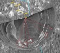
QUOTE Well, not quite. It's close, but I don't understand the discrepency between the distances I get from the tracking data and that on your map. I think one reason may be the map scale --- there was a discussion on this issue a long time ago (it should be somewhere here on the forum). This one is assumed to be at 0.5m/pix but I'm not 100% convinced of that. Another obvious reason is the unaccuracy of my measurements.  On those moves between two outcrop fields I usually use parallax to calculate the net driving distance and those measurements may include errors. In addition, those errors are cumulative on subsequent moves. The big difference with Spirit map (imo) is that the outcrops give a good way to recover from those measurement errors because it's quite easy to compare a polar projection of a nav/pancam mosaic with the base map and find a "best fit" position on it. Anyhow, this "best fit" is a bit subjective and error prone. The advantage is that it is not affected from errors on previous sols estimations; it can even be used to correct the previous ones. An example with the "best fit" estimation for sol 801 position:
|
||
 |
 
|
||
|
Apr 27 2006, 12:23 PM
Post
#1292
|
||
|
Senior Member Group: Moderator Posts: 4279 Joined: 19-April 05 From: .br at .es Member No.: 253 |
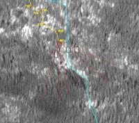
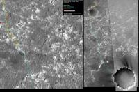
Route map, updated to sol 802.
Rocky terrain for the next 50+ meters. 
|
|
|
|
|
|
|
Apr 27 2006, 01:18 PM
Post
#1293
|
|
 Member Group: Members Posts: 562 Joined: 29-March 05 Member No.: 221 |
QUOTE (Tesheiner @ Apr 27 2006, 01:23 PM)  Rocky terrain for the next 50+ meters. I like the irony of the orbital recon leading the assumption that the etched terrain was unsuitabe for roving and the plains being better, when in fact the opposite is, to a large extent, true. Aaaahhh photo-geology from orbit, don't ya love it 
|
|
|
|
|
Apr 27 2006, 01:39 PM
Post
#1294
|
|
 Senior Member Group: Moderator Posts: 2262 Joined: 9-February 04 From: Melbourne - Oz Member No.: 16 |
QUOTE (Tesheiner @ Apr 27 2006, 06:24 PM) I think one reason may be the map scale --- there was a discussion on this issue a long time ago (it should be somewhere here on the forum). This one is assumed to be at 0.5m/pix but I'm not 100% convinced of that. I don't think that is a problem, I can't see any obvious scaling or rotation to improve the match. QUOTE (Tesheiner @ Apr 27 2006, 06:24 PM) Another obvious reason is the unaccuracy of my measurements. I'm not so sure this is a problem either, your positions look good to me (wrt the outcrops) It may be there is no real problem, I think I need to compare more maps. I'll get back to you... James -------------------- |
|
|
|
|
Apr 27 2006, 01:49 PM
Post
#1295
|
|
|
Senior Member Group: Moderator Posts: 4279 Joined: 19-April 05 From: .br at .es Member No.: 253 |
QUOTE (jamescanvin @ Apr 27 2006, 09:55 AM) What's interesting about this map is it shows the different driving techniques. The 'solid line' of red points shows autonav regions (around 1m between each point) and the more widely spaced points (with yellow lines between) where they are more confident of the terrain (near the start of the sol) and are doing 6-10m (blind) drives before checking for slippage etc. Just imagine what could be done with a better base map and an automated process to extract the route points from the tracking web...  QUOTE (jamescanvin @ Apr 27 2006, 03:39 PM) It may be there is no real problem, I think I need to compare more maps. I'll get back to you... There is another possible issue with the maps. If you compare the images I use on my route map (R15-00822 and R22-00640) they simply don't fit each other 100%, and it's not an issue of scaling or rotation. The reason is that MGS doesn't take a due vertical shot but at an angle, and those two images were taken at different positions. It's the same as trying to fit two images of a stereo pair; they won't. |
|
|
|
|
Apr 28 2006, 12:57 AM
Post
#1296
|
|
|
Senior Member Group: Moderator Posts: 2262 Joined: 9-February 04 From: Melbourne - Oz Member No.: 16 |
QUOTE (Tesheiner @ Apr 27 2006, 11:49 PM) Just imagine what could be done with a better base map and an automated process to extract the route points from the tracking web... Indeed QUOTE (Tesheiner @ Apr 27 2006, 11:49 PM) There is another possible issue with the maps. If you compare the images I use on my route map (R15-00822 and R22-00640) they simply don't fit each other 100%, and it's not an issue of scaling or rotation. The reason is that MGS doesn't take a due vertical shot but at an angle, and those two images were taken at different positions. It's the same as trying to fit two images of a stereo pair; they won't. That's true, I hadn't thought of that, thanks. James -------------------- |
|
|
|
|
Apr 28 2006, 04:02 AM
Post
#1297
|
||
|
Senior Member Group: Moderator Posts: 2262 Joined: 9-February 04 From: Melbourne - Oz Member No.: 16 |
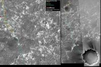
OK i've done a bit more work on this.
Attached is an overlay of all the locations listed on the tracking site on Tesheiner's route map back to sol 775 - this covers 3 'sites' 67, 68 & 69 which are added and matched to the map seperately (it's not one continuous line) there are a couple of interesting things to note: 1) The fit to Tesheiner's route line is very good showing what we already new - what a great job he's doing I find it incredibly hard looking at all these outcrops and trying to figure out whats going on! 2) For two of the three 'sites' I had to rotate my route by around 3 degrees to get it to match with Tesheiner's map following the ground features (I'm not sure about the third). This got me thinking, MGS's orbit is inclided at about 93 degrees and so when crossing the equator at Meridiani will be traveling at 3 degrees from north/south and as it uses a 'brush broom' camera this will be the orientation of the image pixels. My question is, has that been accounted for on this map, or is north really 3 degrees away from 'up'? Which would make a lot of sense compared to what i'm getting from the data tracking data! James
Attached thumbnail(s)
-------------------- |
|
|
|
|
|
|
Apr 28 2006, 11:23 AM
Post
#1298
|
||
|
Senior Member Group: Moderator Posts: 4279 Joined: 19-April 05 From: .br at .es Member No.: 253 |
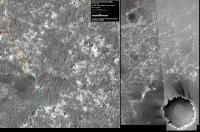
Route map, updated to sol 803.
QUOTE (jamescanvin @ Apr 28 2006, 06:02 AM) My question is, has that been accounted for on this map, or is north really 3 degrees away from 'up'? Which would make a lot of sense compared to what i'm getting from the data tracking data! The map is the "map-projected" version of R15-00822. I did another analysis based on the heading to that crater just at the borded of the ejecta blanket. I compared the heading derived from the pancam images (data tracking data) with the heading derived from the route map (map data), and they are aprox. 1 degree off. |
|
|
|
|
|
|
Apr 28 2006, 12:26 PM
Post
#1299
|
|
|
Senior Member Group: Members Posts: 2998 Joined: 30-October 04 Member No.: 105 |
Great route maps. The route that Oppy is travelling coincides with your proposed route, which makes sense since your proposed route is reasonable. I think that Oppy will arrive at the ejecta blanket at that fresh crater at the border; this makes sense since that crater wil provide an excellent preview of the shallow subsurface and a closeup view of parts of the Victoria rim strata that we cannot easily view closely.
--Bill -------------------- |
|
|
|
|
Apr 28 2006, 09:10 PM
Post
#1300
|
|
|
Senior Member Group: Moderator Posts: 4279 Joined: 19-April 05 From: .br at .es Member No.: 253 |
I'm just at the beginning of a loooong weekend; besides the May 1st holiday I'll take the 2nd & 3rd too.
So no route map updates, at least from my side, until thursday. (time to finish packing things on the caravan...) |
|
|
|
|
Apr 29 2006, 01:25 AM
Post
#1301
|
|
|
Senior Member Group: Members Posts: 2998 Joined: 30-October 04 Member No.: 105 |
We'll take care of things. I've not done much since I've been in such agreement with your route maps that I've not been able to add much. Have a good holiday!
--Bill -------------------- |
|
|
|
|
May 2 2006, 09:48 PM
Post
#1302
|
||
|
Senior Member Group: Moderator Posts: 2262 Joined: 9-February 04 From: Melbourne - Oz Member No.: 16 |
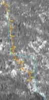
Here is my estimate of Oppys position for sol 807 based on the pancam tracking data.
James -------------------- |
|
|
|
|
|
|
May 3 2006, 09:43 PM
Post
#1303
|
||
|
Senior Member Group: Moderator Posts: 2262 Joined: 9-February 04 From: Melbourne - Oz Member No.: 16 |
And again for Sol 808
James -------------------- |
|
|
|
|
|
|
May 3 2006, 11:06 PM
Post
#1304
|
|
|
Senior Member Group: Members Posts: 2920 Joined: 14-February 06 From: Very close to the Pyrénées Mountains (France) Member No.: 682 |
Hola Tesheiner! You missed 5 sols... pero me parece que no faltaba sol en espana
 James did very well indeed : he put Oppy back on YOUR track so, one more week holiday for you must be fine
-------------------- |
|
|
|
|
May 4 2006, 12:58 AM
Post
#1305
|
|
 Senior Member Group: Members Posts: 1229 Joined: 24-December 05 From: The blue one in between the yellow and red ones. Member No.: 618 |
QUOTE (jamescanvin @ May 3 2006, 11:43 AM) And again for Sol 808 James Well done, JC, looks like we are very close to the halfway point to the hem of Victoria's apron. (Or should we call it her robe-of-state?  ) )Tell us when we reach that milestone so we can all have a nice cup of tea to celebrate. 
-------------------- My Grandpa goes to Mars every day and all I get are these lousy T-shirts!
|
|
|
|
|

|
Lo-Fi Version | Time is now: 28th April 2024 - 09:17 AM |
|
RULES AND GUIDELINES Please read the Forum Rules and Guidelines before posting. IMAGE COPYRIGHT |
OPINIONS AND MODERATION Opinions expressed on UnmannedSpaceflight.com are those of the individual posters and do not necessarily reflect the opinions of UnmannedSpaceflight.com or The Planetary Society. The all-volunteer UnmannedSpaceflight.com moderation team is wholly independent of The Planetary Society. The Planetary Society has no influence over decisions made by the UnmannedSpaceflight.com moderators. |
SUPPORT THE FORUM Unmannedspaceflight.com is funded by the Planetary Society. Please consider supporting our work and many other projects by donating to the Society or becoming a member. |
|