Distant vistas, Endeavour, Iazu, and beyond |

  |
Distant vistas, Endeavour, Iazu, and beyond |
 Mar 16 2010, 06:44 PM Mar 16 2010, 06:44 PM
Post
#211
|
|
|
Senior Member  Group: Members Posts: 3516 Joined: 4-November 05 From: North Wales Member No.: 542 |
Very nice Bill! That shows the situation really well.
I think I've found a terrestrial analog  : :http://www.nat-park.com/mule-ears-big-bend-national-park/ |
 |
 
|
|
Mar 16 2010, 07:20 PM
Post
#212
|
|
|
Senior Member Group: Members Posts: 2998 Joined: 30-October 04 Member No.: 105 |
I know the Big Bend region well-- I used to take a holiday in the FtDavis/Marfa/Alpine area many years ago. 10,000 foot altitude, all volcanic rhyolite (sorta a continental basalt).
A personal terrestrial analog during that trip just occurred to me. The drive across Texas is long and for the most part traverses flat, flat terrain. Many miles from the mountains of west Texas-Big Bend you begin seeing the peaks just start to poke up over the horizon and grow over the better part a day, much like the distant craters are doing at Meridiani. It's been 20 years, but let me see if I can locate old photgraphs and see how far away we spotted the mountains. I'm thinking 20-30 miles, but you know how fish stories are... --Bill -------------------- |
|
|
|
|
Mar 16 2010, 07:46 PM
Post
#213
|
|
 Member Group: Members Posts: 593 Joined: 20-April 05 Member No.: 279 |
QUOTE (Bill Harris @ Mar 16 2010, 07:20 PM)  I'm thinking 20-30 miles, but you know how fish stories are... I think I can believe that. The day I saw the images of the Bopolu peaks, I was driving at just around sunset to my local supermarket. From the crest of a hill (in Airdrie, North Lanarkshire, Scotland) I saw mountains on the western horizon, back-lit by the sky, which turned out to be Goat Fell and its chums on Arran. Google Earth says "80km" - fifty miles - line of sight to those 2000 foot hills. Andy |
|
|
|
|
Mar 16 2010, 08:31 PM
Post
#214
|
|
 Dublin Correspondent Group: Admin Posts: 1799 Joined: 28-March 05 From: Celbridge, Ireland Member No.: 220 |
50 miles certainly isn't outrageous when visibility is good and the target is high. I lived on the south coast of Ireland in West Waterford and could easily see 100-200m headlands to the east about 30 miles away from about 10 meters above sealevel when visibility was reasonably OK. Hook head lighthouse was somewhere between 50-60 miles to the east and it's top (at about 25m at a guess) was below the horizon or close enough that I could never make it out, even with a telescope on a perfectly clear day. It was almost always obvious on clear nights though, strobing just over the horizon.
I also recall a holiday in Switzerland in the 80's when the Alps were an obvious hulking presence to the south when viewed from the foothills of the Jura mountains about 40-50miles to the North. No peaking up over the horizon there - as I recall I had to look up at the peaks even at that distance but memory may be confusing me. |
|
|
|
|
Mar 16 2010, 09:16 PM
Post
#215
|
|
 Senior Member Group: Members Posts: 4247 Joined: 17-January 05 Member No.: 152 |
At risk of stretching this thread title completely off the planet Mars, I can't help chiming in. I've seen the Olympic mountains in Washington state from Vancouver on a very clear day, at about 140 km (85 miles) distance. And Mt Rainier, Washington is sometimes visible from Victoria, BC at a whopping 210 km (130 miles). I'm sure people can top these sightings, though - Hawaii or similar islands from the sea? The Andes or other coastal ranges from the ocean?
|
|
|
|
|
Mar 16 2010, 09:29 PM
Post
#216
|
|
 The Poet Dude Group: Moderator Posts: 5551 Joined: 15-March 04 From: Kendal, Cumbria, UK Member No.: 60 |
From my backyard I can see the Andromeda Galaxy... 2 million light years away...
I win 
-------------------- |
|
|
|
|
Mar 16 2010, 11:35 PM
Post
#217
|
|
|
Senior Member Group: Members Posts: 2085 Joined: 13-February 10 From: Ontario Member No.: 5221 |
I can confirm what fredk says about seeing Washington from Vancouver. Mt. Baker is the most visible one (should be quite a show when it blows!), but with a little height the others beyond are visible too.
And yes, one can see clear across the Strait of Georgia to Vancouver Island, on a clear day. But we should really be getting back to Mars now..... 
|
|
|
|
|
Mar 17 2010, 01:19 AM
Post
#218
|
|
|
Senior Member Group: Members Posts: 2998 Joined: 30-October 04 Member No.: 105 |
This isn't too bad a digression-- we're relating the Distant Vistas we see on Mars to something we can relate to.
I found some notes on Texas road map which suggest that I started seeing the mountains in the Ft Davis (Ft Stockton, actually) area somwhere to the west of Midland, Texas, which would make the distance 85-90 miles. Back to Mars: although the air is thin, the dust is very very fine and can be easily held in suspension. The dustiest part of an atmosphere is that part close to the ground. The line of sight to Endeavour and Bopolu is close to the ground for a few kilometers until the elevation starts to drop off. It is amazing how far we can see here. --Bill -------------------- |
|
|
|
|
Mar 17 2010, 08:15 AM
Post
#219
|
|
 Senior Member Group: Moderator Posts: 2262 Joined: 9-February 04 From: Melbourne - Oz Member No.: 16 |
Back on Mars, I made a start at matching the features ngunn spotted. On sol 2181 the drive direction mosaic includes both the new feature and Boplou so aligning it with my reprojected HRSC images is fairly easy. I didn't get a chance to finish making a graphic but I got far enough to think the ID is indeed the high part of the Miyamoto rim that ngunn pointed to.

-------------------- |
|
|
|
|
Mar 17 2010, 10:39 AM
Post
#220
|
|
|
Member Group: Members Posts: 877 Joined: 7-March 05 From: Switzerland Member No.: 186 |
Here is a (1/4 res.) crop from http://hirise.lpl.arizona.edu/ESP_012820_1780
(1,6Mb) http://www.greuti.ch/oppy/ESP_012820_1780_...twin_others.jpg This post has been edited by Tman: Mar 17 2010, 07:12 PM -------------------- |
|
|
|
|
Mar 17 2010, 12:08 PM
Post
#221
|
|
 Senior Member Group: Members Posts: 1087 Joined: 19-February 05 From: Close to Meudon Observatory in France Member No.: 172 |
QUOTE (fredk @ Mar 16 2010, 10:16 PM) ...And Mt Rainier, Washington is sometimes visible from Victoria, BC at a whopping 210 km (130 miles)... From the City of Dijon in Burgundy, by a very clear day, you can see Mont-Blanc peak : that's a similar distance (220km). "Avenue du Mont-Blanc"is named in Dijon after it...
|
|
|
|
|
Mar 17 2010, 01:14 PM
Post
#222
|
|
|
Solar System Cartographer Group: Members Posts: 10159 Joined: 5-April 05 From: Canada Member No.: 227 |
"Mt Rainier, Washington is sometimes visible from Victoria, BC at a whopping 210 km (130 miles)."
Yes, I've seen that myself, on an unusually clear day! But the rainier the day, the less you can see. Phil -------------------- ... because the Solar System ain't gonna map itself.
Also to be found posting similar content on https://mastodon.social/@PhilStooke Maps for download (free PD: https://upload.wikimedia.org/wikipedia/comm...Cartography.pdf NOTE: everything created by me which I post on UMSF is considered to be in the public domain (NOT CC, public domain) |
|
|
|
|
Mar 17 2010, 03:31 PM
Post
#223
|
|
|
Senior Member Group: Members Posts: 3516 Joined: 4-November 05 From: North Wales Member No.: 542 |
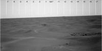
QUOTE (jamescanvin @ Mar 17 2010, 08:15 AM) I got far enough to think the ID is indeed the high part of the Miyamoto rim that ngunn pointed to. Ironically I'd just about persuaded myself Fred must be right. I think I'll just wait till a consensus is reached. One thing I have done is make a few measurements which convince me that we are gradually opening up the angle between the 'Mule Ears' and the thing to the right (which needs a name so I'm going to call it 'Rockaway' unless someone has a better suggestion). Whatever they turn out to be they provide a convenient 'fixed point' for comparisons (animations?) of the changing scene as we move south. A rough distance for 'Rockaway' should already be derivable. Another suggestion, since I don't know how to do it myself, is that since our view of the 'Mule Ears' is more or less unchanging it should be possible to get a clearer picture of them by stacking all the images we get while we're on this heading. |
|
|
|
|
Mar 17 2010, 03:41 PM
Post
#224
|
||
|
The Poet Dude Group: Moderator Posts: 5551 Joined: 15-March 04 From: Kendal, Cumbria, UK Member No.: 60 |
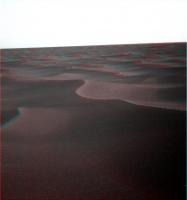
Opening up nicely on the horizon now...
-------------------- |
|
|
|
|
|
|
Mar 17 2010, 08:37 PM
Post
#225
|
|||
|
Member Group: Members Posts: 877 Joined: 7-March 05 From: Switzerland Member No.: 186 |
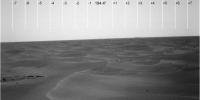
QUOTE (Tman @ Mar 15 2010, 05:26 PM) I get these values from the position on sol 2181. The feature at 181° should be a part of the twin craters. But it seems to me it's just the left rim of the left crater (from the viewpoint of Oppy on sol 2181) and because of the twin craters cover about 5 degrees in this image your 7 degrees could roughly match nevertheless... I'm a bit embarrassed  I made a mistake on the shifting of the L/R Pancam views in my post above, i.e. the azimuth of the pancam mast (180°/193,4) as displayed in the Tracking Web Interface have to shift in the opposite way around for the used L6 filter images - means they have to be 181° and 194,4° ...sorry folks! I made a mistake on the shifting of the L/R Pancam views in my post above, i.e. the azimuth of the pancam mast (180°/193,4) as displayed in the Tracking Web Interface have to shift in the opposite way around for the used L6 filter images - means they have to be 181° and 194,4° ...sorry folks!
It's -------------------- |
||
|
|
|
||
|

|
Lo-Fi Version | Time is now: 9th May 2024 - 10:28 AM |
|
RULES AND GUIDELINES Please read the Forum Rules and Guidelines before posting. IMAGE COPYRIGHT |
OPINIONS AND MODERATION Opinions expressed on UnmannedSpaceflight.com are those of the individual posters and do not necessarily reflect the opinions of UnmannedSpaceflight.com or The Planetary Society. The all-volunteer UnmannedSpaceflight.com moderation team is wholly independent of The Planetary Society. The Planetary Society has no influence over decisions made by the UnmannedSpaceflight.com moderators. |
SUPPORT THE FORUM Unmannedspaceflight.com is funded by the Planetary Society. Please consider supporting our work and many other projects by donating to the Society or becoming a member. |
|