March 15, 2010 PDS release |

  |
March 15, 2010 PDS release |
 Mar 15 2010, 12:05 PM Mar 15 2010, 12:05 PM
Post
#1
|
|
 Member  Group: Members Posts: 568 Joined: 20-April 05 From: Silesia Member No.: 299 |
Finally, the data are here:
http://lroc.sese.asu.edu/data/LRO-L-LROC-2....0/LROLRC_0001/ Unfortunately, the server is running terribly slow. -------------------- Free software for planetary science (including Cassini Image Viewer).
http://members.tripod.com/petermasek/marinerall.html |
 |
 
|
|
Mar 15 2010, 12:24 PM
Post
#2
|
||
|
Member Group: Members Posts: 568 Joined: 20-April 05 From: Silesia Member No.: 299 |
Very strange images from WAC camera.
-------------------- Free software for planetary science (including Cassini Image Viewer).
http://members.tripod.com/petermasek/marinerall.html |
|
|
|
|
|
|
Mar 15 2010, 01:13 PM
Post
#3
|
|
|
Founder Group: Chairman Posts: 14432 Joined: 8-February 04 Member No.: 1 |
That's not strange - that's what they should look like. It's a pushframe camera. Unfortunately, as for MARCI, they appear to be only releasing the raw data.
|
|
|
|
|
Mar 15 2010, 01:38 PM
Post
#4
|
|
|
Solar System Cartographer Group: Members Posts: 10150 Joined: 5-April 05 From: Canada Member No.: 227 |
Don't forget, though, that the THEMIS visible images were also comprised of multiple framelets like that, and a bit later the properly mosaicked versions were also available.
Phil -------------------- ... because the Solar System ain't gonna map itself.
Also to be found posting similar content on https://mastodon.social/@PhilStooke NOTE: everything created by me which I post on UMSF is considered to be in the public domain (NOT CC, public domain) |
|
|
|
|
Mar 15 2010, 02:13 PM
Post
#5
|
|
|
Rover Driver Group: Members Posts: 1015 Joined: 4-March 04 Member No.: 47 |
Looks like flipping each 'band' will make it look a lot nicer. Should be easy to script up for someone who has the ability (not me!).
|
|
|
|
|
Mar 15 2010, 02:32 PM
Post
#6
|
|
|
Solar System Cartographer Group: Members Posts: 10150 Joined: 5-April 05 From: Canada Member No.: 227 |
Until I can do a search for specific images, this won't be very useful to me. Probably won't be long...
Phil -------------------- ... because the Solar System ain't gonna map itself.
Also to be found posting similar content on https://mastodon.social/@PhilStooke NOTE: everything created by me which I post on UMSF is considered to be in the public domain (NOT CC, public domain) |
|
|
|
|
Mar 15 2010, 04:25 PM
Post
#7
|
|
|
Founder Group: Chairman Posts: 14432 Joined: 8-February 04 Member No.: 1 |
QUOTE (Phil Stooke @ Mar 15 2010, 01:38 PM)  and a bit later the properly mosaicked versions were also available. Yeah - but after 3 years of MARCI, they've not done it, and I doubt they'll do it for this either. |
|
|
|
|
Mar 15 2010, 06:04 PM
Post
#8
|
|
|
Junior Member Group: Members Posts: 23 Joined: 6-November 09 Member No.: 5017 |
LOLA. I want my LOLA. I've got rapid prototyping machines waiting to make moon models.
Rick |
|
|
|
|
Mar 15 2010, 06:22 PM
Post
#9
|
|
|
Junior Member Group: Members Posts: 94 Joined: 15-October 09 Member No.: 4979 |
A bit off topic, but I was hoping someone can help-
I can't seem to get IMG2PNG to work on my computer- downloaded the latest version, and I was hoping to explore some of the LROC data release. However, the exe file gets this error "This application has failed to start because cftisio.dll was not found. Re-installing the application may fix this problem." I kept the cftisio.dll file in the same folder. Same result if I copy both the .exe and .dll files to the C drive... any suggestions? Running on an XP system. |
|
|
|
|
Mar 15 2010, 07:22 PM
Post
#10
|
|
 Administrator Group: Admin Posts: 5172 Joined: 4-August 05 From: Pasadena, CA, USA, Earth Member No.: 454 |
Just got this email:
QUOTE The NASA Planetary Data System announces the first release of data from the Lunar Reconnaissance Orbiter (LRO) mission. This release includes raw and derived products for data acquired from the start of mapping on September 15, 2009, through December 14, 2009, along with data collected during the commissioning phase June 23 - September 14, 2009.
Data sets from the following experiments are included in this release: · Cosmic Ray Telescope for Effects of Radiation (CRaTER) · Diviner Lunar Radiometer Experiment (DLRE) · Lyman-Alpha Mapping Project (LAMP) · Lunar Exploration Neutron Detector (LEND) · Lunar Orbiter Laser Altimeter (LOLA) · Lunar Reconnaissance Orbiter Camera (LROC) · Mini-Radio Frequency technology demonstration (Mini-RF) LRO data are archived at the PDS Planetary Plasma Interactions (PPI), Geosciences, Imaging, and Navigation and Ancillary Information (NAIF) Nodes. The data may be accessed from these nodes' web sites and from the main PDS home page, http://pds.nasa.gov/ or http://pds.nasa.gov/subscription_service/SS-20100315.html. PDS offers two services for searching the LRO archives: The Planetary Image Atlas at the Imaging Node allows selection of LRO data by specific search criteria. The Image Atlas will be available shortly. Please check the Imaging Node web site for information about its availability. http://pds-imaging.jpl.nasa.gov/index_pdsimg_new.html. The Lunar Orbital Data Explorer at the Geosciences Node allows searching and downloading of LRO data and other lunar orbital data sets (Clementine and Lunar Prospector). http://ode.rsl.wustl.edu/moon/. To receive email announcements of future releases of LRO data, please use the PDS Subscription Service at http://pds.jpl.nasa.gov/tools/subscription_service/top.cfm. -------------------- My website - My Patreon - @elakdawalla on Twitter - Please support unmannedspaceflight.com by donating here.
|
|
|
|
|
Mar 16 2010, 12:19 AM
Post
#11
|
|
|
Junior Member Group: Members Posts: 22 Joined: 20-June 09 Member No.: 4830 |
The LOLA data are now also available !
In addition to the RDR and GDR products, I would like to point you to some products which were made with users like you in mind! First, the big binary GDR files (maps) were converted to GeoJPEG2000, much easier to import in software like ArcGIS. Projection information is included in the headers, so that should work transparently. location: http://imbrium.mit.edu/DATA/LOLA_GDR/ Second, we are releasing ready-made textures for Celestia. Many of you know Celestia (shatters.net/celestia), and some of you produced normal maps from the Kaguya altimetry data. In addition to a LOLA normal map, a texture showing the topography in false-color was made. location: http://imbrium.mit.edu/EXTRAS/CELESTIA/ Enjoy ! Erwan for the LOLA Science Team |
|
|
|
|
Mar 16 2010, 12:42 AM
Post
#12
|
|
|
Junior Member Group: Members Posts: 23 Joined: 6-November 09 Member No.: 5017 |
Erwan,
Thanks for that news about the LOLA data. However, I'm a right-brained artist working on a Mac with an app like MacDEM, which was able to work with the MGS MOLA .img files *very* nicely, given the numbers of rows and columns. I suspect that I won't be able to use anything like ArcGIS. Any ideas on how I might be able to get 16-bit grayscale maps out of the files you cited? In the meantime, I'll forward the URL to my rapid prototype folks; perhaps they'll know what to do for the models. I'd really love to be able to put the grayscale maps into Terragen. Rick EDIT: Holy cow, I just downloaded one of the "smaller" 17MB JPEG2000 files, and it's already in 16-bit B&W. I see files in there that are 3+ GB. Yeeeoooowww. Many, many, many thanks! - Rick |
|
|
|
|
Mar 16 2010, 01:14 AM
Post
#13
|
||
|
Solar System Cartographer Group: Members Posts: 10150 Joined: 5-April 05 From: Canada Member No.: 227 |
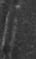
Just a taste of the bounty to come:
Tracks of Lunokhod 2. I can tell at once that the old route map will need a total revision. This is only the browse image! To find it I downloaded CUMINDEX.CAT, a cumulative index file, comma delimited text file. In Excel I deleted all the columns I'm not interested in, sorted by longitude, and found the latitude i wanted, then found the image in the browse folder. The image number is in my file's name. Phil -------------------- ... because the Solar System ain't gonna map itself.
Also to be found posting similar content on https://mastodon.social/@PhilStooke NOTE: everything created by me which I post on UMSF is considered to be in the public domain (NOT CC, public domain) |
|
|
|
|
|
|
Mar 16 2010, 01:17 AM
Post
#14
|
|
|
Junior Member Group: Members Posts: 22 Joined: 20-June 09 Member No.: 4830 |
QUOTE (Rick Sternbach @ Mar 15 2010, 07:42 PM) EDIT: Holy cow, I just downloaded one of the "smaller" 17MB JPEG2000 files, and it's already in 16-bit B&W. I see files in there that are 3+ GB. Yeeeoooowww. Many, many, many thanks! Rick, glad the JP2s are working for you (they are all unsigned INT16). But the IMGs are there as well, just in case! |
|
|
|
|
Mar 16 2010, 01:18 AM
Post
#15
|
|
|
Merciless Robot Group: Admin Posts: 8783 Joined: 8-December 05 From: Los Angeles Member No.: 602 |
Whoa-ho-ho!!! Great eye, Phil!
-------------------- A few will take this knowledge and use this power of a dream realized as a force for change, an impetus for further discovery to make less ancient dreams real.
|
|
|
|
|

|
Lo-Fi Version | Time is now: 24th April 2024 - 11:28 AM |
|
RULES AND GUIDELINES Please read the Forum Rules and Guidelines before posting. IMAGE COPYRIGHT |
OPINIONS AND MODERATION Opinions expressed on UnmannedSpaceflight.com are those of the individual posters and do not necessarily reflect the opinions of UnmannedSpaceflight.com or The Planetary Society. The all-volunteer UnmannedSpaceflight.com moderation team is wholly independent of The Planetary Society. The Planetary Society has no influence over decisions made by the UnmannedSpaceflight.com moderators. |
SUPPORT THE FORUM Unmannedspaceflight.com is funded by the Planetary Society. Please consider supporting our work and many other projects by donating to the Society or becoming a member. |
|