MSL "Drive, drive, drive" toward Glenelg, The scientists (mostly) get the keys - sols 38-56 |

  |
MSL "Drive, drive, drive" toward Glenelg, The scientists (mostly) get the keys - sols 38-56 |
 Sep 28 2012, 11:49 PM Sep 28 2012, 11:49 PM
Post
#316
|
||
|
Senior Member  Group: Members Posts: 1074 Joined: 21-September 07 From: Québec, Canada Member No.: 3908 |
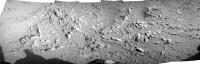
Sol 52 navcam pan of outcrop to be examined(?)
|
|
 |
 
|
|
|
Sep 29 2012, 12:13 AM
Post
#317
|
|
|
Senior Member Group: Members Posts: 2082 Joined: 13-February 10 From: Ontario Member No.: 5221 |
Yep, those 90 degree angles are gonna ruffle the loons' feathers...
|
|
|
|
|
Sep 29 2012, 12:18 AM
Post
#318
|
|
 Administrator Group: Admin Posts: 5172 Joined: 4-August 05 From: Pasadena, CA, USA, Earth Member No.: 454 |
Moved my own and a few other peoples' posts on polar projected images to the Geomorphology thread.
-------------------- My website - My Patreon - @elakdawalla on Twitter - Please support unmannedspaceflight.com by donating here.
|
|
|
|
|
Sep 29 2012, 12:25 AM
Post
#319
|
|
 Senior Member Group: Members Posts: 1465 Joined: 9-February 04 From: Columbus OH USA Member No.: 13 |
So no word yet on any chemcam or apxs measurements of Jake?
-------------------- |
|
|
|
|
Sep 29 2012, 12:37 AM
Post
#320
|
|
|
Member Group: Members Posts: 866 Joined: 15-March 05 From: Santa Cruz, CA Member No.: 196 |
Thanks for continued interest in this. Since well be travelling for quite some time across the fallout area downwind of the entry path and heatshield impact, it wouldn't be too surprising (though perhaps sadly unlikely) to chance encounter more shiny EDL flotsam. though i wonder if anyone has a better idea of how far this type of flotsam (fabrics?) would be expected to travel given the wind, maybe it mostly landed far downwind and what we saw on SOLs 38&50 was skycrane or tether jetsam.
Hopefully the MSL team will take interest to image one and we can rule out speculars off shiny rock faces (or just bright white material standing out against dull dusty backgrounds overloading the sensor and causing a streak in SOL 38). If they were simple rock facet speculars, there should be shiny bits in a lot of images. Seems fun to compile a compendium of sparkly bits and map them for future causes, so here's a start on a hit list, i hope it continues: >> SOL 20 Little bright squiggle (thanks Fredk) >> SOL 38: LEFT - RIGHT >> SOL 50: LEFT - RIGHT The Sol 50 one should be caught in that Sol 50 aft M100 panorama. And here's the sol50 bright speck, viewed with M100: (thanks Fredk) <--hard to match up surroundings, perhaps its a different angle. >> SOL 51: Add this to the list: MR SOL 51 -- Ronalds post >> SOL 64 Another bright bit at the bottom of the frame (thanks Fredk) >> another one, thanks Zelenyikot presumably in Post #401 (post links seem buggy, captured post 401 url instead brings up post 421... hmmm. >> geez, a big one in the sol 107-109 gigapan lurking in the far left middle frame |
|
|
|
|
Sep 29 2012, 01:03 AM
Post
#321
|
|
 Senior Member Group: Moderator Posts: 3431 Joined: 11-August 04 From: USA Member No.: 98 |
QUOTE (charborob @ Sep 28 2012, 05:49 PM)  Sol 52 navcam pan of outcrop to be examined(?) Could be, but seems like they regularly take Navcams off the right side of the rover there. |
|
|
|
|
Sep 29 2012, 01:39 AM
Post
#322
|
|
|
Senior Member Group: Members Posts: 1074 Joined: 21-September 07 From: Québec, Canada Member No.: 3908 |
QUOTE (mhoward @ Sep 28 2012, 08:03 PM) Could be, but seems like they regularly take Navcams off the right side of the rover there. I was basing my assumption on this status report. |
|
|
|
|
Sep 29 2012, 03:33 AM
Post
#323
|
|
|
Administrator Group: Admin Posts: 5172 Joined: 4-August 05 From: Pasadena, CA, USA, Earth Member No.: 454 |
QUOTE (jmknapp @ Sep 28 2012, 05:25 PM) So no word yet on any chemcam or apxs measurements of Jake? It wasn't until after the briefing was over and I'd managed to get my couple questions in via Twitter that I realized they said nothing whatever about Jake, and now I'm kicking myself for not asking about it. They've been really circumspect about mineralogy/composition, but that's consistent with the pattern on Phoenix. I remember a couple of months into the Phoenix mission Lou Friedman got irritated with my reporting on operational details (they're trying to get X sample into Y TEGA chamber, etc) but no science; but of course that was a reflection of what they were sharing in press briefings. There is time set aside at the DPS meeting in two weeks (Wednesday Oct 17, in the afternoon) for first MSL results. Hopefully they'll be ready to share some preliminary stuff by then. -------------------- My website - My Patreon - @elakdawalla on Twitter - Please support unmannedspaceflight.com by donating here.
|
|
|
|
|
Sep 29 2012, 03:44 AM
Post
#324
|
|
 Senior Member Group: Members Posts: 1619 Joined: 12-February 06 From: Bergerac - FR Member No.: 678 |
Sol 51 M34 panorama, yet uncomplete
  And Sol 52 Navcam pan : 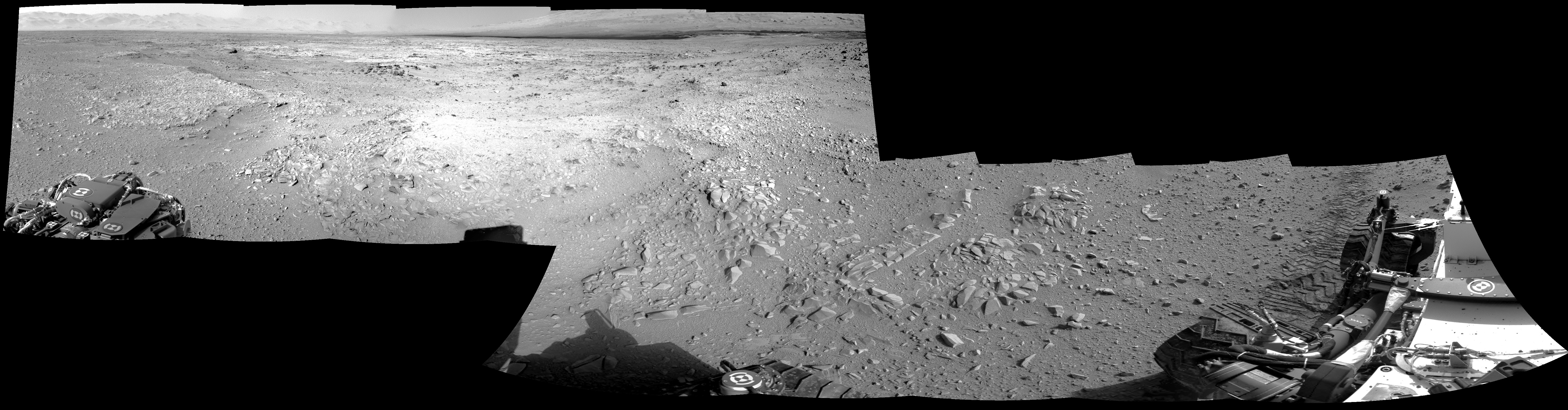 (I'm posting this late because of having watched Avatar, the director's cut )
-------------------- |
|
|
|
|
Sep 29 2012, 05:28 AM
Post
#325
|
|
|
Junior Member Group: Members Posts: 87 Joined: 17-May 08 Member No.: 4114 |
QUOTE (fthurber @ Sep 28 2012, 09:01 AM) I am surprised that they did not do a ChemCam raster scan of Hottah. They did zap Goulburn back around sol 16 http://mars.jpl.nasa.gov/msl/multimedia/images/?ImageID=4546 http://mars.jpl.nasa.gov/msl/multimedia/ra...era=CHEMCAM_RMI Edit: I'm not clear what the target of the 5 shot sequence above from sol 19 was. They also DAN'd one of the scours http://www.unmannedspaceflight.com/index.p...st&p=189899 |
|
|
|
|
Sep 29 2012, 08:03 AM
Post
#326
|
|
 Junior Member Group: Members Posts: 40 Joined: 29-December 11 Member No.: 6295 |
QUOTE (fthurber @ Sep 28 2012, 07:01 PM) I am surprised that they did not do a ChemCam raster scan of Hottah. Maybe they could get have gotten lucky and flashed off some of the cementing mineral. I'm surprised as well why we bypassed Hottah without any further examination. Instead we are looking 2-3 weeks now at Glenelg for a suitable place to drill for a SAM probe. why that ? Cheers, Udo -------------------- But to be a lament on the lips of the loved one is glorious, For the prosaic goes toneless to Orcus below. (Friedrich Schiller: Naenie)
Home of marspages.eu and plutoidenpages.eu |
|
|
|
|
Sep 29 2012, 09:00 AM
Post
#327
|
|
|
Member Group: Members Posts: 470 Joined: 24-March 04 From: Finland Member No.: 63 |
QUOTE (udolein @ Sep 29 2012, 08:03 AM) I'm surprised as well why we bypassed Hottah without any further examination. Instead we are looking 2-3 weeks now at Glenelg for a suitable place to drill for a SAM probe. As mentioned in press conference, here are some reasons: - The arm calibration hadn't been completed when Curie was at Hottah - The first sample to SAM needs to be fines and before that, the arm sample delivery system needs to be cleaned with those fines (martian sand or similar) - Hottah would be a difficult sample to drill, since it's a rock made out of many different types of material of varying hardness - The science team thinks Glenelg will present even better first targets - Failing finding better targets, they think similar rocks will crop up, and failing even that, they will have to double back from Glenelg anyway Personally I think they should sample this Hottah type outcrop eventually, unless there is something really special at Glenelg. I'd be interested in the formation process of this rock. Is it duricrust formed in the dryness after the river period, or rock formed after layers of other material gathered on top of it? -------------------- Antti Kuosmanen
|
|
|
|
|
Sep 29 2012, 12:25 PM
Post
#328
|
|
|
Member Group: Members Posts: 282 Joined: 18-June 04 Member No.: 84 |
Glenelg is looking basaltic to me.
|
|
|
|
|
Sep 29 2012, 02:01 PM
Post
#329
|
|
|
Solar System Cartographer Group: Members Posts: 10151 Joined: 5-April 05 From: Canada Member No.: 227 |
Care to explain why?
Phil -------------------- ... because the Solar System ain't gonna map itself.
Also to be found posting similar content on https://mastodon.social/@PhilStooke Maps for download (free PD: https://upload.wikimedia.org/wikipedia/comm...Cartography.pdf NOTE: everything created by me which I post on UMSF is considered to be in the public domain (NOT CC, public domain) |
|
|
|
|
Sep 29 2012, 03:10 PM
Post
#330
|
||
|
Junior Member Group: Members Posts: 40 Joined: 29-December 11 Member No.: 6295 |
We seem to have a strong wind on Sol 51 ...
Pebbles swirling around ... Curiosity: stand firm !  Cheers, Udo -------------------- But to be a lament on the lips of the loved one is glorious, For the prosaic goes toneless to Orcus below. (Friedrich Schiller: Naenie)
Home of marspages.eu and plutoidenpages.eu |
|
|
|
|
|
|

|
Lo-Fi Version | Time is now: 25th April 2024 - 02:15 PM |
|
RULES AND GUIDELINES Please read the Forum Rules and Guidelines before posting. IMAGE COPYRIGHT |
OPINIONS AND MODERATION Opinions expressed on UnmannedSpaceflight.com are those of the individual posters and do not necessarily reflect the opinions of UnmannedSpaceflight.com or The Planetary Society. The all-volunteer UnmannedSpaceflight.com moderation team is wholly independent of The Planetary Society. The Planetary Society has no influence over decisions made by the UnmannedSpaceflight.com moderators. |
SUPPORT THE FORUM Unmannedspaceflight.com is funded by the Planetary Society. Please consider supporting our work and many other projects by donating to the Society or becoming a member. |
|