To the Cape! (part 2), For real this time! |

  |
To the Cape! (part 2), For real this time! |
 Jun 28 2008, 08:21 AM Jun 28 2008, 08:21 AM
Post
#91
|
|
|
Member  Group: Members Posts: 206 Joined: 15-August 07 From: Shrewsbury, Shropshire Member No.: 3233 |
QUOTE (ElkGroveDan @ Jun 28 2008, 08:31 AM)  This back and forth of capes and bays likely occurs in a manner analogous to a meandering stream. Over the eons the shapes will migrate back and forth as bays fill up and capes are eroded away...and the crater grows ever larger (assuming some external condition doesn't cause it to become filled in by migrating sand dunes or such.) The problem with this argument if I understand it correctly is that the capes consist of ancient undisturbed strata and not the recent deposits you would see on the bank of a river. I think that the argument only works if Victoria crater is getting bigger at the same sort of rate that the capes are moving. Then there would always be a supply of fresh undisturbed strata from which to carve out the new capes. |
 |
 
|
|
Jun 28 2008, 02:16 PM
Post
#92
|
|
|
Senior Member Group: Members Posts: 2998 Joined: 30-October 04 Member No.: 105 |
Agreed, but I've not been able to wrap my brain around a plausible mechanism to explain the "scalloped" rim around Victoria (et al). With a couple of prevailing wind directions, there shouldn't be such symmetry in the scallops. I'm sure that the explanation is as simple as the ones covering stream meanders or salients and recesses, but I've not stumbled upon it.
--Bill -------------------- |
|
|
|
|
Jun 28 2008, 02:22 PM
Post
#93
|
|
 Senior Member Group: Members Posts: 2173 Joined: 28-December 04 From: Florida, USA Member No.: 132 |
Concerning cracks and weathering around Victoria's rim, I wonder what effect the shock from the impact that caused the crater has. The blast must have left a pattern of disruption and cracks radiating for some distance that had an effect on future weathering.
|
|
|
|
|
Jun 28 2008, 02:26 PM
Post
#94
|
|
 Member Group: Members Posts: 267 Joined: 5-February 06 Member No.: 675 |
QUOTE (nprev @ Jun 27 2008, 09:10 PM) Mmm...differential weathering? I've seen apparent discontinuities like this in the past on Earth; maybe the prevailing wind path around the two vertically separated regions is just different enough to cause the disparity. (I'm assuming that the whole formation is old, old, old...) My amateurish observation is that there is a broad lower band (just above the talus deposits) where the stratification is quite noticeable while on the band above that, the stratification is much less distinct. I'm assuming the whole wall were looking at was exposed simultaneously with the formation of the crater (or sometime thereafter). Two possibilities come to mind: 1. The level with marked stratification is made up of alternating strata of differing physical or chemical composition, and so the strata are eroded much differently which makes their differences strikingly visible. 2. The level with marked stratification has broader strata -- i.e., they were laid down in response to slower changes -- and so the erosion is more noticeable. Comments from the experts are welcome. Steve M |
|
|
|
|
Jun 28 2008, 04:06 PM
Post
#95
|
|
 Senior Member Group: Admin Posts: 4763 Joined: 15-March 05 From: Glendale, AZ Member No.: 197 |
QUOTE (PaulM @ Jun 28 2008, 12:21 AM) The problem with this argument if I understand it correctly is that the capes consist of ancient undisturbed strata and not the recent deposits you would see on the bank of a river. It's not true that the deposits on the banks of a river are necessarily recent. Rivers cut through some very, very old layers just as the wind on Mars is doing. Take a trip to the bottom of the Grand Canyon. There are entire banks in places made of Vishnu Schist which is 1.7 billion years old. The same is true the world over. In fact the best way to locate old layers is to examine the banks of a river (when there is no convenient road-cut nearby.) -------------------- If Occam had heard my theory, things would be very different now.
|
|
|
|
|
Jun 28 2008, 04:10 PM
Post
#96
|
|
|
Senior Member Group: Admin Posts: 4763 Joined: 15-March 05 From: Glendale, AZ Member No.: 197 |
QUOTE (centsworth_II @ Jun 28 2008, 06:22 AM) Concerning cracks and weathering around Victoria's rim, I wonder what effect the shock from the impact that caused the crater has. Certainly radial fractures could create the seeds of an erosion pattern that might evolve into the resulting symmetry we still see after so many eons. -------------------- If Occam had heard my theory, things would be very different now.
|
|
|
|
|
Jun 29 2008, 10:06 PM
Post
#97
|
|
 Member Group: Members Posts: 276 Joined: 11-December 07 From: Dar es Salaam, Tanzania Member No.: 3978 |
The question of whether the pattern of the crater wall is due to the radial fractures produced by the impact or whether its because of other factors depends, I think, on the frequency of occurence of such craters with such exhibiting such a pattern.
If this 'Victorian spikes' design is particularly unusual for the region and we assume uniformity in the nature of the sedimentary rocks, one could be tempted to conclude that the impact is responsible for the pattern. Another reason is because of a combination of the impact and nature of the rocks factors? Is there another crater with such a pattern nearby? -------------------- |
|
|
|
|
Jun 29 2008, 10:24 PM
Post
#98
|
|
 Senior Member Group: Moderator Posts: 2785 Joined: 10-November 06 From: Pasadena, CA Member No.: 1345 |
QUOTE (Bill Harris @ Jun 28 2008, 10:16 AM) Agreed, but I've not been able to wrap my brain around a plausible mechanism to explain the "scalloped" rim around Victoria (et al). From the abstract of a recent article discussing Victoria crater (see Nature of Victoria's Dark Streaks thread, post 430): "...sand [in Victoria Crater] is supplied from outside the crater and is presently escaping it's topographic trap. This process presents a possible explanation for the serrated margin of Victoria crater, through abrasion of the soft rock as trapped sands are blown out of the crater and carve alcoves under various seasonal winds." What causes the regular spacing of the scallops? Good question. It could be from radial fractures from the crater formation (as centsworth II suggested), or it could be initiated from subtle turbulence effects as sand carrying winds swirl around the interior rim of the crater. It'd be neat to watch it evolve over time (a geologically long time, I reckon). -Mike -------------------- Some higher resolution images available at my photostream: http://www.flickr.com/photos/31678681@N07/
|
|
|
|
|
Jun 30 2008, 12:24 AM
Post
#99
|
|
 Senior Member Group: Members Posts: 1229 Joined: 24-December 05 From: The blue one in between the yellow and red ones. Member No.: 618 |
Why is the rim shape so rare on Mars? Sand and wind and craters are everywhere; I'd wager the cape and bay shape is less than one in ten thousand.

-------------------- My Grandpa goes to Mars every day and all I get are these lousy T-shirts!
|
|
|
|
|
Jun 30 2008, 12:46 AM
Post
#100
|
||
|
Senior Member Group: Members Posts: 2998 Joined: 30-October 04 Member No.: 105 |
I've seen other examples in HiRISE images of scalloped craters, I ought to dig through and catalog similar crater-forms. Ugh.
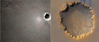
At one time I speculated that the radial scalloped rim was due to the Anatolia Features, which were originally seen near Eagle-Endurance craters and are presumably concealed under the dune-sand south of the type area, and have been noted near the southeast rim of Victoria. Attached is an image showing the trends of the Anatolia Features and also the trends of Victoria's scalloped rim (I don't recall if it's mine, I might have purloined that Victoria image from a post). You can see similarities, but you'd need to run stats on the trends to make sense. Presented FWIW. ---Bill
Attached thumbnail(s)
-------------------- |
|
|
|
|
|
|
Jun 30 2008, 12:48 AM
Post
#101
|
|
|
Senior Member Group: Moderator Posts: 2785 Joined: 10-November 06 From: Pasadena, CA Member No.: 1345 |
QUOTE (Shaka @ Jun 29 2008, 08:24 PM) Why is the rim shape so rare on Mars? Sand and wind and craters are everywhere; I'd wager the cape and bay shape is less than one in ten thousand. Maybe the underlying strata that Victoria impacted are atypical?  [EDIT: Just saw Bill Harris' post. I KNEW we shoulda spent more time at Anatolia!] -------------------- Some higher resolution images available at my photostream: http://www.flickr.com/photos/31678681@N07/
|
|
|
|
|
Jun 30 2008, 02:46 AM
Post
#102
|
|
|
Senior Member Group: Members Posts: 1229 Joined: 24-December 05 From: The blue one in between the yellow and red ones. Member No.: 618 |
We thrashed this one around during the trek south to Victoria. Some of us tried to apply the hypothesis that Meridiani craters had been buried and later exhumed.
But buried/exhumed craters are not likely as rare on Mars as cape-and-bay rims. I tried to imagine a crater that filled with water while it was still hot, then froze and was buried. It was later exhumed, and, meanwhile, collapsed as the ice sublimated. I've not yet seen any clear evidence to back this scenario.  I keep waiting for the paper that makes Vikky comprehensible. -------------------- My Grandpa goes to Mars every day and all I get are these lousy T-shirts!
|
|
|
|
|
Jun 30 2008, 02:58 AM
Post
#103
|
|
|
Senior Member Group: Members Posts: 2998 Joined: 30-October 04 Member No.: 105 |
QUOTE I KNEW we shoulda spent more time at Anatolia! Anatolia was one of the first of many wonder that Oppy came across after emerging from Eagle crater. At the time we prioritized the 90-day operational life of the rover, so it was reasonable that we didn't spend an inordinate amount of time there. And, short of having a track-hoe along to do serious excavation, I don't know how much could have been gained beyond Pancam views. I do wish we'd been able to have inspected a few more Anatolia Features on the traverse southward. If we do continue the traverse around Victoria, we ought to look at the Anatolia Feature that is intersected by the southeast crater rim. My initial, and continuing, impression of the Anatolia Features is that they are solution cavities along joints (or rather, a joint system intermittently widened by solution cavities). That is, until more evidence comes our way...  --Bill -------------------- |
|
|
|
|
Jun 30 2008, 09:23 AM
Post
#104
|
|
|
Senior Member Group: Members Posts: 3516 Joined: 4-November 05 From: North Wales Member No.: 542 |
QUOTE (Juramike @ Jun 30 2008, 01:48 AM) Maybe the underlying strata that Victoria impacted are atypical? Well I had a go at explaining the capes and bays way, way back. I think it was my first venture into a Mars topic. Anyhow there are new people here now and the idea has never gone away so here it is once more. I think there was an uneven layer of water-rich material below the presently exposed strata and that this was fluidised by the Victoria impact. This resulted in selective sapping and collapse of the original crater walls, leaving vertical cliffs untypical of impact craters (but frequently produced on Earth by undermining and removal of material). Much of the fluidised material would have ponded in the centre of the crater and subsequently wasted away by sublimation and wind erosion. There are a number of possibilities for the easily fluidised water-rich layer, including some recently proposed highly hydrated martian minerals, for which I'd have to hunt a bit for the reference. Why so rare? You need an impact to occur bang on top of one of these super-hydrated deposits, located at just the right depth relative to the size of the impact. OK folks, shoot it down (EDIT: or ignore it) all over again!! |
|
|
|
|
Jul 1 2008, 05:02 AM
Post
#105
|
|
 Member Group: Members Posts: 239 Joined: 18-December 07 From: New York Member No.: 3982 |
No new images since Friday. Is something going on?
|
|
|
|
|

|
Lo-Fi Version | Time is now: 16th April 2024 - 11:52 PM |
|
RULES AND GUIDELINES Please read the Forum Rules and Guidelines before posting. IMAGE COPYRIGHT |
OPINIONS AND MODERATION Opinions expressed on UnmannedSpaceflight.com are those of the individual posters and do not necessarily reflect the opinions of UnmannedSpaceflight.com or The Planetary Society. The all-volunteer UnmannedSpaceflight.com moderation team is wholly independent of The Planetary Society. The Planetary Society has no influence over decisions made by the UnmannedSpaceflight.com moderators. |
SUPPORT THE FORUM Unmannedspaceflight.com is funded by the Planetary Society. Please consider supporting our work and many other projects by donating to the Society or becoming a member. |
|