Victoria's Stratigraphy |

  |
Victoria's Stratigraphy |
 Oct 2 2006, 01:56 AM Oct 2 2006, 01:56 AM
Post
#1
|
|
|
Senior Member  Group: Members Posts: 2998 Joined: 30-October 04 Member No.: 105 |
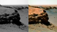
Here are a series of false-color L257 Pancams of the current Oppy traverse stop. I'm still in the "arch the eyebrows and muttering 'fascinating' " mode so I don't have any words of wisdom right away. We can discuss over the next few day/sols before she moves on to the next miracle...
Cabo Frio: (order is #3, #1, #2 from left): This post has been edited by Bill Harris: Nov 12 2006, 03:36 PM -------------------- |
 |
 
|
|
Oct 2 2006, 02:00 AM
Post
#2
|
|
|
Senior Member Group: Members Posts: 2998 Joined: 30-October 04 Member No.: 105 |
Image #4 at Cabo Frio:
This post has been edited by Bill Harris: Nov 12 2006, 03:37 PM -------------------- |
|
|
|
|
Oct 2 2006, 02:07 AM
Post
#3
|
|
|
Senior Member Group: Members Posts: 2998 Joined: 30-October 04 Member No.: 105 |
Cabo Verde (order is #1, #2, #4, #3, from left):
This post has been edited by Bill Harris: Nov 12 2006, 03:38 PM -------------------- |
|
|
|
|
Oct 2 2006, 02:12 AM
Post
#4
|
|
|
Merciless Robot Group: Admin Posts: 8783 Joined: 8-December 05 From: Los Angeles Member No.: 602 |
Good grief, and mega<clinks> for the swear jar...thank you, Ed.
My first impression of Cabo Frio is that there seems to be a preferential side of the formation for wind erosion, and it looks like it's the opposite side from where Cabo Verde (did I spell it right, ustrax? Please don't hit me again!   ) exhibited the same effect, and THAT seems really strange...almost as if there's an "air channel" in and out of the crater. Does the low atmospheric pressure & diurnal variation make that kind of a difference? ) exhibited the same effect, and THAT seems really strange...almost as if there's an "air channel" in and out of the crater. Does the low atmospheric pressure & diurnal variation make that kind of a difference? 
-------------------- A few will take this knowledge and use this power of a dream realized as a force for change, an impetus for further discovery to make less ancient dreams real.
|
|
|
|
| Guest_Myran_* |
Oct 2 2006, 03:41 AM
Post
#5
|
|
Guests |
Wind erosion - of course we see wind erosion!
Once I did visit Australia, and the tourguide took us to a site and claimed the rocks and cliffs were as they were from the age of the dinosaurs. Coming from a location where everything have changed since the last iceage just 10 000 years ago, that idea gave me vertigo. Yet those cliffs and bedrock in Australia are something to compare with what we have here, then multiply the age times 10, 20 or perhaps even 50 times. Over such timescales we only can be happy that erosion might have been slow on Mars. |
|
|
|
|
Oct 2 2006, 05:24 AM
Post
#6
|
|
 Senior Member Group: Members Posts: 2228 Joined: 1-December 04 From: Marble Falls, Texas, USA Member No.: 116 |
Bill, I can see you are finding interesting things to do in your retirement.
I have to go to bed...I must perform paid labor, tomorrow... ...Still dreaming... ...enjoy. -------------------- ...Tom
I'm not a Space Fan, I'm a Space Exploration Enthusiast. |
|
|
|
|
Oct 2 2006, 10:41 AM
Post
#7
|
|
|
Senior Member Group: Members Posts: 2998 Joined: 30-October 04 Member No.: 105 |
Not only the geology of this locale, but also, and as importantly, the geomorphology, "how did it get to look like it is today?" is open for study here. Getting the ground-truth here will help us in interpreting MRO imagery. Although, by Earth-standards Mars has a thin, almost non-existent atmosphere, we can see that it is currently _the_ major player in erosion, transport and deposition.
One thought: Mars has a weak magnetic field and a thin atmosphere, so the cosmic ray flux is orders of magnitude higher than on Earth. And the erosional process is much slower so a given rock will lay on trhe surface for thousands or millions of years. What is the effect of millions of billions of cosmic ray impacts on the component mineral crystals of a rock? The crystal lattice must be perforated like a zeolite... On the "R-word". I do look at it as "graduation" and having paid my dues on my day job, with a 27-year investment paying off. I've got a lot to do the next few years. I'll continue in the OT section later today... --Bill -------------------- |
|
|
|
|
Oct 2 2006, 10:59 AM
Post
#8
|
|
|
Member Group: Members Posts: 100 Joined: 20-May 06 Member No.: 780 |
I do find the stratigraphy of Cabo Frio to be mystifying. There are the long diagonal layers on the side, but out at the tip there are horizontal layers. How the <clink, clink> could that happen?
|
|
|
|
|
Oct 2 2006, 12:39 PM
Post
#9
|
||
|
Junior Member Group: Members Posts: 48 Joined: 26-August 05 Member No.: 475 |
Cabo Frio in 3D
|
|
|
|
|
|
|
Oct 2 2006, 01:49 PM
Post
#10
|
|
|
Member Group: Members Posts: 242 Joined: 17-February 04 From: Ohio, USA Member No.: 34 |
QUOTE (diane @ Oct 2 2006, 10:59 AM)  I do find the stratigraphy of Cabo Frio to be mystifying. There are the long diagonal layers on the side, but out at the tip there are horizontal layers. How the <clink, clink> could that happen? Diane I'm not sure which view you're looking at, but in general, if a series of parallel planes are inclined (as in some cross-bedding), one cross-section will show the dipping layers, but if you rotate the block ninety degrees, a cross section will show horizontal strata. One of the images about 3/4 down on this page http://www.geologie.uni-stuttgart.de/onlin...en/Seite7_1.htm shows what I'm trying to describe. Lee |
|
|
|
|
Oct 2 2006, 02:22 PM
Post
#11
|
|
|
Senior Member Group: Members Posts: 3516 Joined: 4-November 05 From: North Wales Member No.: 542 |
QUOTE (diane @ Oct 2 2006, 11:59 AM) I do find the stratigraphy of Cabo Frio to be mystifying. There are the long diagonal layers on the side, but out at the tip there are horizontal layers. How the <clink, clink> could that happen? I'm annoyed I can't find it but somebody posted the picture in one of the threads with both the horizontal and diagonal lines highlighted and offering the following suggested interpretation: horizontal are stratigraphic beds, diagonal are fracture planes produced by the shock of impact. Seemed reasonable to me. |
|
|
|
|
Oct 2 2006, 03:25 PM
Post
#12
|
|
 Junior Member Group: Members Posts: 71 Joined: 11-May 05 From: Colorado USA Member No.: 386 |
QUOTE (ngunn @ Oct 2 2006, 08:22 AM) I'm annoyed I can't find it but somebody posted the picture in one of the threads with both the horizontal and diagonal lines highlighted and offering the following suggested interpretation: horizontal are stratigraphic beds, diagonal are fracture planes produced by the shock of impact. Seemed reasonable to me. I am somewhat concerned that what we see as stratigraphic bedding or even fracture planes might be caused by wind erosion that occurs within only a few centimeters of the regolith surface. Then as the surface recedes, more rock is exposed and a new layer of erosion occurs. This seems consistent with some of the angles of the outcrop strata with respect to the angle of the ground surface of Duck Bay. That "marker bed" on Cabo Verde might not be true layers, but rather evidence for successive cycles of wind erosion. Each layer is a climate change causing a wind change, causing different erosion. When you see blocks planed flush to the surface of the ground, wind erosion takes on a rather dreadful importance. We sometimes don't understand it because of our earth geology biases. Scott |
|
|
|
|
Oct 2 2006, 04:06 PM
Post
#13
|
||
 Member Group: Members Posts: 153 Joined: 8-February 04 From: Phoenix, AZ USA Member No.: 9 |
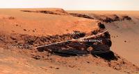
Here is my quick-n-dirty interpretation of the stratal geometry of Cabo Verde on a photo posted yesterday by Nix.
A couple of notes: 1) the lighter-colored upper bedrock unit is in stratal continuity with the lower striped unit...it looks like the upper, steeper beds are foreset laminae and the lower horizontal to gently inclined beds are toesets deposited by the migration of a dune (this is what I call festoon crossbedding!) 2) my interpretation would be that these are the deposits of a prograding eolian dune with well-developed avalanche-face foresets, and that the toesets are built out of grain-flow tongues separated by grain-fall drapes and wind-ripple translatent strata 3) the ejecta is bloody thick here and most, if not all, of the overlying evaporite beds have been blasted away..only a highly-fragmented zone of evaporite-rich ejecta blocks remain...this is likely to be variable around the crater and I'm sure we will see some in-place evaporite beds on top of the eolian beds...maybe even in the next bay
-------------------- Tim Demko
BioLink site |
|
|
|
|
|
|
Oct 2 2006, 04:56 PM
Post
#14
|
|
 Senior Member Group: Members Posts: 3419 Joined: 9-February 04 From: Minneapolis, MN, USA Member No.: 15 |
That all makes sense to me. What doesn't make sense is how the evaporite-rich ejecta strata seems to be *more* erosion-resistant than the aeolian deposits. We seem to see this phenomenon all around the crater, a lighter-toned bed of apparently evaporite-rich rock that appears to form a resistant bed, which has stayed in place even while the aeolian deposits below them are undercut.
The evaporite we've seen here, both unshocked (out on the plains) and shocked (within Endurance), seems to be the softest rock around. It's certainly a lot softer than the volcanic rocks over at Gusev. It almost appears, at times, so friable that it would simply crumble if held in the hand and squeezed. Any idea how such soft rock becomes the most erosion-resistant rock in the walls of such a big crater? -the other Doug -------------------- The trouble ain't that there is too many fools, but that the lightning ain't distributed right. -Mark Twain
|
|
|
|
|
Oct 2 2006, 05:08 PM
Post
#15
|
|
 Chief Assistant Group: Admin Posts: 1409 Joined: 5-January 05 From: Ierapetra, Greece Member No.: 136 |
QUOTE (dvandorn @ Oct 2 2006, 06:56 PM) ... Any idea how such soft rock becomes the most erosion-resistant rock in the walls of such a big crater? -the other Doug Could it have anything to do with the depth of the crater? ..wind tunneling down inside and around in the bowl of the crater, leaving the top layers relatively intact? just a guess... Nico -------------------- photographer, space imagery enthusiast, proud father and partner, and geek.
http://500px.com/sacred-photons & |
|
|
|
|

|
Lo-Fi Version | Time is now: 18th April 2024 - 06:00 PM |
|
RULES AND GUIDELINES Please read the Forum Rules and Guidelines before posting. IMAGE COPYRIGHT |
OPINIONS AND MODERATION Opinions expressed on UnmannedSpaceflight.com are those of the individual posters and do not necessarily reflect the opinions of UnmannedSpaceflight.com or The Planetary Society. The all-volunteer UnmannedSpaceflight.com moderation team is wholly independent of The Planetary Society. The Planetary Society has no influence over decisions made by the UnmannedSpaceflight.com moderators. |
SUPPORT THE FORUM Unmannedspaceflight.com is funded by the Planetary Society. Please consider supporting our work and many other projects by donating to the Society or becoming a member. |
|