Lunar Spacecraft Images, A place for moon panoramas, mosaics etc. |

  |
Lunar Spacecraft Images, A place for moon panoramas, mosaics etc. |
 May 31 2007, 02:14 PM May 31 2007, 02:14 PM
Post
#136
|
|
 Interplanetary Dumpster Diver  Group: Admin Posts: 4404 Joined: 17-February 04 From: Powell, TN Member No.: 33 |
Definitely the old man...I'm not saying you're old, but he lived in the moon, so that would explain your "reprocessed" lunar images.
-------------------- |
 |
 
|
|
Jul 20 2007, 12:42 AM
Post
#137
|
||
|
Solar System Cartographer Group: Members Posts: 10151 Joined: 5-April 05 From: Canada Member No.: 227 |
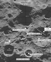
Here's a map of the lunar south polar region with a few sites added. LEx was a lander which competed for the LRO spare capacity opportunity eventually won by LCROSS. The background is the new radar image of the south pole from Arecibo, courtesy Campbell et al.
I have posted a version of this elsewhere (I can't find it now), but this version is corrected from that earlier one. Phil
-------------------- ... because the Solar System ain't gonna map itself.
Also to be found posting similar content on https://mastodon.social/@PhilStooke Maps for download (free PD: https://upload.wikimedia.org/wikipedia/comm...Cartography.pdf NOTE: everything created by me which I post on UMSF is considered to be in the public domain (NOT CC, public domain) |
|
|
|
|
|
|
Jul 20 2007, 09:45 AM
Post
#138
|
||
|
Junior Member Group: Members Posts: 59 Joined: 18-July 07 From: London, UK Member No.: 2873 |
hey all,
after ages of lurking (doesn't everyone say that?) i thought i would finally try and contribute something. the moon certainly isn't my speciality, but i've had fun with these images nonetheless. while i was achiving some data at work i came across a microfiche from the apollo 15 metric mapping camera, which i hadn't seen before. fortunately for me and my scanner they are all online, with a lot of other apollo stuff, at lpi - have a look, it's a treasure trove. i'm sure there are people here who can do the images more justice than i can, but i've had a bit of play around with the apollo 15 set anyway because i hadn't seen it used anywhere on here. there are a few more on my webpage, but here's a low-res panorama (for me to learn how to post images if nothing else!) apollo 15 rev 4 panorama
cheers, pete |
|
|
|
|
|
|
Jul 20 2007, 12:58 PM
Post
#139
|
|
 The Poet Dude Group: Moderator Posts: 5551 Joined: 15-March 04 From: Kendal, Cumbria, UK Member No.: 60 |
Very nice Pete, and welcome aboard UMSF!

-------------------- |
|
|
|
|
Jul 20 2007, 01:18 PM
Post
#140
|
|
|
Founder Group: Chairman Posts: 14432 Joined: 8-February 04 Member No.: 1 |
For those wondering - that's Pete, previously seen here:
http://www.unmannedspaceflight.com/index.php?showtopic=4139 Doug |
|
|
|
|
Dec 29 2007, 03:58 PM
Post
#141
|
|||
 Member Group: Members Posts: 568 Joined: 20-April 05 From: Silesia Member No.: 299 |
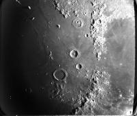
Litte gift for all dissapointed by Smart-1 and Kaguya's fuzzy images.
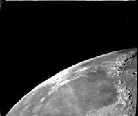
Mariner 10 - one day after launch (November 1973). Image FDS0002659
Mariner 10 - one day after launch (November 1973). Image FDS0002667 -------------------- Free software for planetary science (including Cassini Image Viewer).
http://members.tripod.com/petermasek/marinerall.html |
||
|
|
|
||
|
Dec 29 2007, 05:56 PM
Post
#142
|
|||
|
Member Group: Members Posts: 568 Joined: 20-April 05 From: Silesia Member No.: 299 |
.. and more
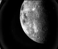
Mariner 10 - one day after launch (November 1973). Image FDS0004637
Mariner 10 - one day after launch (November 1973). Image FDS0002267 -------------------- Free software for planetary science (including Cassini Image Viewer).
http://members.tripod.com/petermasek/marinerall.html |
||
|
|
|
||
|
Dec 29 2007, 06:39 PM
Post
#143
|
|
|
Member Group: Members Posts: 808 Joined: 10-October 06 From: Maynard Mass USA Member No.: 1241 |
UMSFers,
Where can I find the complete image library of the Surveyor 3 mission? (it returned ~10K images, i would like the hi res, hopefully calibrated, -etc...) Does this exist on-line or do I need to order/buy it? tnx ! -------------------- CLA CLL
|
|
|
|
|
Dec 30 2007, 02:22 AM
Post
#144
|
|
|
Solar System Cartographer Group: Members Posts: 10151 Joined: 5-April 05 From: Canada Member No.: 227 |
It exists only in hard copy. You have to go to the LPI library, search the negatives and scan them.
Phil -------------------- ... because the Solar System ain't gonna map itself.
Also to be found posting similar content on https://mastodon.social/@PhilStooke Maps for download (free PD: https://upload.wikimedia.org/wikipedia/comm...Cartography.pdf NOTE: everything created by me which I post on UMSF is considered to be in the public domain (NOT CC, public domain) |
|
|
|
|
Dec 30 2007, 10:56 AM
Post
#145
|
|
|
Senior Member Group: Members Posts: 1870 Joined: 20-February 05 Member No.: 174 |
"Where can I find the complete image library of the Surveyor 3 mission"
Surveyor data was returned by slow-scan analog transmission and recorded on analog tape. A very small amount (punched card computing, almost no hard disk capability... this was 1966-68 or so) was digitized and image processed to sharpen and improve analog ghosting, etc, or for photometric/colorimetric analysis and reported in published papers. I doubt any of that exists anywhere findable and restorable and I have to assume no original analog data tapes of Surveyor images survive, or so close to none they scientifically don't count. Images were recorded by some sort of data-recorder camera that had essentially a high precision slow-scan TV, and the slowly rendered single-frame image raster was exposed directly onto film. What I'd like to know is the location and status of such FIRST GENERATION film negatives. They are the primary and original data record. |
|
|
|
|
Dec 30 2007, 02:06 PM
Post
#146
|
|
|
Solar System Cartographer Group: Members Posts: 10151 Joined: 5-April 05 From: Canada Member No.: 227 |
They would be either at JPL or at the National Space Science Data Center at Goddard.
Phil -------------------- ... because the Solar System ain't gonna map itself.
Also to be found posting similar content on https://mastodon.social/@PhilStooke Maps for download (free PD: https://upload.wikimedia.org/wikipedia/comm...Cartography.pdf NOTE: everything created by me which I post on UMSF is considered to be in the public domain (NOT CC, public domain) |
|
|
|
|
Dec 30 2007, 05:36 PM
Post
#147
|
|
|
Interplanetary Dumpster Diver Group: Admin Posts: 4404 Joined: 17-February 04 From: Powell, TN Member No.: 33 |
Cool images, Peter. Mariner 10 really did have an incredible imaging system. It was the first planetary spacecraft with a vidicon system that used a blast of light to get rid of after-images (Viking and Voyager also did this), which makes the image quality much better.
I will say that the Kayuga images we have seen from the science cameras have been quite sharp - we should see more in the future, since Kayuga began its official science mission in the last few days. The images we have been seeing are mostly from the engineering cameras and the HDTV camera, which is there for PR purposes. -------------------- |
|
|
|
|
Dec 30 2007, 06:21 PM
Post
#148
|
||
|
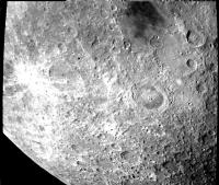
Member Group: Members Posts: 568 Joined: 20-April 05 From: Silesia Member No.: 299 |
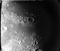
Apollo 15 landing site observed by Mariner 10. Mount Hadley and Delta Hadley are clearly visible.
Image FDS0002285 (November 1973) -------------------- Free software for planetary science (including Cassini Image Viewer).
http://members.tripod.com/petermasek/marinerall.html |
|
|
|
|
|
|
Dec 30 2007, 07:01 PM
Post
#149
|
|
|
Member Group: Members Posts: 808 Joined: 10-October 06 From: Maynard Mass USA Member No.: 1241 |
Phil & Ed
thanks for the replies...it just seems short sighted not to transfer these historic data sets to a digital format. I will gladly fill out the grant papers to do this multi-year task! cheers! -------------------- CLA CLL
|
|
|
|
|
Dec 30 2007, 10:20 PM
Post
#150
|
|
|
Solar System Cartographer Group: Members Posts: 10151 Joined: 5-April 05 From: Canada Member No.: 227 |
The Surveyor images are archived on negatives at LPI, along with numerous photos of assembled mosaics, many of which come with frame index number overlays. They would help you locate individual frames. But it's a bit of a mess. Surveyor was quickly overshadowed by Apollo and people lost interest - of course, there wasn't an amateur image processing community in those days.
To my mind the most dramatic and interesting early product to make with Surveyor 3 images would be a wide-angle panoramic view shot in the first couple of days after landing. The systematic high resolution imaging I used for my pan was shot late, with high sun and no shadows, so it's very bland. There might be some good coverage at high resolution from early in the mission as well. Phil -------------------- ... because the Solar System ain't gonna map itself.
Also to be found posting similar content on https://mastodon.social/@PhilStooke Maps for download (free PD: https://upload.wikimedia.org/wikipedia/comm...Cartography.pdf NOTE: everything created by me which I post on UMSF is considered to be in the public domain (NOT CC, public domain) |
|
|
|
|

|
Lo-Fi Version | Time is now: 25th April 2024 - 04:17 PM |
|
RULES AND GUIDELINES Please read the Forum Rules and Guidelines before posting. IMAGE COPYRIGHT |
OPINIONS AND MODERATION Opinions expressed on UnmannedSpaceflight.com are those of the individual posters and do not necessarily reflect the opinions of UnmannedSpaceflight.com or The Planetary Society. The all-volunteer UnmannedSpaceflight.com moderation team is wholly independent of The Planetary Society. The Planetary Society has no influence over decisions made by the UnmannedSpaceflight.com moderators. |
SUPPORT THE FORUM Unmannedspaceflight.com is funded by the Planetary Society. Please consider supporting our work and many other projects by donating to the Society or becoming a member. |
|