The "Lump of Good Hope", Significant..? |

  |
The "Lump of Good Hope", Significant..? |
| Guest_Edward Schmitz_* |
 Feb 26 2007, 04:49 AM Feb 26 2007, 04:49 AM
Post
#31
|
|
Guests |
after seeing fredk lbl (thanks for that), it seems that there is a significant under side that is exposed. I'm pretty sure this is, by far, the largest sheltered area we seen.
ed |
 |
 
|
| Guest_Edward Schmitz_* |
Feb 27 2007, 05:01 PM
Post
#32
|
|
|
Guests |
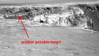
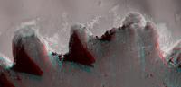
Another possible lump? I'm beginning to think they are ejecta blocks... The post drive navcams on sol 1100 seems to indicate they are not targetting the lump.
ed
Attached thumbnail(s)
|
|
|
|
|
|
|
Feb 27 2007, 05:37 PM
Post
#33
|
|
|
Senior Member  Group: Moderator Posts: 4279 Joined: 19-April 05 From: .br at .es Member No.: 253 |
QUOTE (Edward Schmitz @ Feb 27 2007, 06:01 PM)  The post drive navcams on sol 1100 seems to indicate they are not targetting the lump. Maybe. Although the navcams are centered at 180º (i.e. south), the post-drive pancams are centered at SW. My impression is that they are still focusing on taking some shots of Cabo Corrientes from a point nearby the lump. |
|
|
|
|
Feb 27 2007, 06:40 PM
Post
#34
|
|
|
Member Group: Members Posts: 235 Joined: 2-August 05 Member No.: 451 |
I've been assuming that everything above the light colored stripe is ejecta that rained down after the blast that formed Victoria, and this 'Lump of Good Hope' seems to be above that line. Some of you folks with much more geology experience than I've got (I can usually tell a rock from a brick) are saying that the LOGH might be cemented ejecta that has slipped. That sounds OK to me, but it makes me wonder what made it cement together in such a uniform way when all the other ejecta has lots of descrete chunks embedded. I'm open minded about this, so answering is worth while, but to me it looks like this is a very large single lump that held its integrety during the crater formation process.
|
|
|
|
|
Feb 27 2007, 07:06 PM
Post
#35
|
|
|
Member Group: Members Posts: 242 Joined: 17-February 04 From: Ohio, USA Member No.: 34 |
antoniseb,
Your question is very appropriate. The LOGH could be just a VERY large fragment that was deposited along with all the other smaller fragments in the breccia. |
|
|
|
|
Feb 27 2007, 07:46 PM
Post
#36
|
|
 Senior Member Group: Members Posts: 3419 Joined: 9-February 04 From: Minneapolis, MN, USA Member No.: 15 |
QUOTE (antoniseb @ Feb 27 2007, 12:40 PM) I've been assuming that everything above the light colored stripe is ejecta that rained down after the blast that formed Victoria... I'm not sure I'd use the term "rained down," here. I think "surged onto" is more appropriate, this close to the cratering event. It makes a difference when you try to envision the dynamics that emplaced the ejecta layer. QUOTE (antoniseb @ Feb 27 2007, 12:40 PM) Some of you folks with much more geology experience than I've got (I can usually tell a rock from a brick) are saying that the LOGH might be cemented ejecta that has slipped. That sounds OK to me, but it makes me wonder what made it cement together in such a uniform way when all the other ejecta has lots of descrete chunks embedded. I'm open minded about this, so answering is worth while, but to me it looks like this is a very large single lump that held its integrety during the crater formation process. While the dynamics of the ejecta surge around a cratering event can be well-described in aggregate, the conditions at any given point in the surge tend to be chaotically dynamic. Pockets of gas, pockets of vaporized volatiles (such as water or water ice), layers of soft rock underlying layers of harder rock -- all of these things cause localized discontinuities within adjacent parts of the surge flow. That's all a rather long-winded way of saying that conditions can be just right to cement some large blocks of ejecta, while adjacent portions of the flow can consist of far more shattered blocks of rock. It's also possible for surge conditions to favor the ejection, whole, of some large blocks of pre-existing rockbeds while all around these large blocks you find far smaller, shattered pieces. In other words, the conditions in the local ejecta surge around a cratering event could account for the LOGH to be either cemented ejecta (i.e., a breccia of some sort) or an intact block of rockbed. So, in this case, theories aren't enough -- we need (hint, hint) to go take a close look at it (hint, hint) to determine the truth either way (hint, hint).  -the other Doug -------------------- The trouble ain't that there is too many fools, but that the lightning ain't distributed right. -Mark Twain
|
|
|
|
|
Feb 27 2007, 08:10 PM
Post
#37
|
|
|
Member Group: Members Posts: 235 Joined: 2-August 05 Member No.: 451 |
QUOTE (dvandorn @ Feb 27 2007, 02:46 PM) So, in this case, theories aren't enough -- we need (hint, hint) to go take a close look at it (hint, hint) to determine the truth either way (hint, hint). I had the impression that the immediate goal was to find a clean exposed accessible deep cliff so we can examine the chemistry of the layers as they get deeper down. Perhaps looking at the LOGH would be a good scond mission if Opportunity can climb out of the crater at it's first entry point. |
|
|
|
|
Feb 27 2007, 08:35 PM
Post
#38
|
|||
 Senior Member Group: Members Posts: 4246 Joined: 17-January 05 Member No.: 152 |
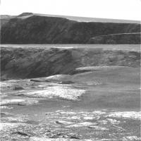
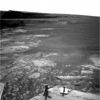
Here's the sol 1100 pancam view of the top of the Lump, heavily stretched because of the afternoon lighting:
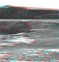
And the corresponding anagram:
The top of the Lump is the farthest part of the foreground surface, between centre and right edge. Apart from Lumpiness, this is a spectacular image! Behind the Lump we have Cabo Corrientes. Immediately behind that, jutting about a third of the way in from the right, is Cape Desire. Behind that, Cabo Anonimo, and behind that, Cape St. Mary rising up to the Beacon at the highest point. I'm quite sure that behind that is Duck Bay, though we can't quite see our entry point yet. Whew, that's quite the stretch of Victoria's drive foreshortened into one pancam frame! |
||
|
|
|
||
|
Feb 28 2007, 03:55 PM
Post
#39
|
|
|
Member Group: Members Posts: 242 Joined: 17-February 04 From: Ohio, USA Member No.: 34 |
That is *quite* a dramatic view - worthy of a post card.
I also noticed that the breccia on this side of Cabo Corrientes also looks to be quite lumpy. That is, the fragments in the breccia look much larger than they have in other places. |
|
|
|
|
Feb 28 2007, 04:06 PM
Post
#40
|
|
 Senior Member Group: Members Posts: 1619 Joined: 12-February 06 From: Bergerac - FR Member No.: 678 |
The view from Good Hope.
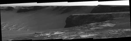 And the traditional desktop picture  : :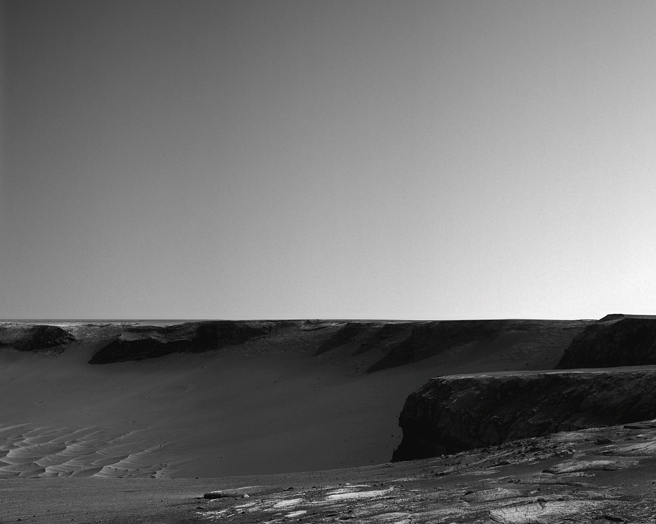
-------------------- |
|
|
|
|
Feb 28 2007, 06:00 PM
Post
#41
|
|
|
Member Group: Members Posts: 235 Joined: 2-August 05 Member No.: 451 |
I'm a little surprised that there are no images of the apparent fault line running up to LOGH.
|
|
|
|
|
Feb 28 2007, 06:35 PM
Post
#42
|
|
|
Member Group: Members Posts: 242 Joined: 17-February 04 From: Ohio, USA Member No.: 34 |
I was to see some images of the ?faulted? area too. The rear hazcam gives the only view of any spot near that area, but nothing obvious shows up. It's possible that it's a feature that is more obvious from above than at ground level.
PS Great views, Ant.
|
|
|
|
|
Feb 28 2007, 06:59 PM
Post
#43
|
|||
|
Senior Member Group: Members Posts: 4246 Joined: 17-January 05 Member No.: 152 |
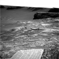
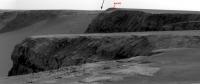
The sol 1100 navcams show the area of the "linear" feature. The route map shows that we were sitting right on the feature on sol 1100, and we look along it (so it's foreshortened) towards the southwest in these two navcam frames, which I've stretched quite a bit:
It looks like more of the same exposed rock to these non-geological eyes. |
||
|
|
|
||
|
Mar 1 2007, 06:37 AM
Post
#44
|
||
 Senior Member Group: Members Posts: 2228 Joined: 1-December 04 From: Marble Falls, Texas, USA Member No.: 116 |
Absolutely beautiful, Ant103. I wish I could speak French to tell you how much I enjoyed your sol 1100 panorama. When I did my version it hurt me to destroy the mood by stretching the daylight out of those lovely, shadowed cliffs. But we so rarely get raws that can be contrast stretched as far as these could. The devil in me wanted to see the details in the rocks.
 QUOTE (dvandorn @ Feb 27 2007, 01:46 PM) ... In other words, the conditions in the local ejecta surge around a cratering event could account for the LOGH to be either cemented ejecta (i.e., a breccia of some sort) or an intact block of rockbed. So, in this case, theories aren't enough -- we need (hint, hint) to go take a close look at it (hint, hint) to determine the truth either way (hint, hint). ... Doug: I thought your post was an excellent summary of many of the complexities that need to be considered. This thing still has me wondering. In the first navcam set it looks like a breccia, but in the next set it looks like a block of ejected bedrock. I think a "closer look" needs only to be the pancams already captured but not yet revealed. I worry that they might leave me eating crow.Those pancams will eventually come down the pipe. Until then, here is a HiRise anaglyph of the vicinity that I was looking at tonight, in case it might be useful to someone. I'm still having fun with the raws, but enough already.
-------------------- ...Tom
I'm not a Space Fan, I'm a Space Exploration Enthusiast. |
|
|
|
|
|
|
Mar 1 2007, 01:45 PM
Post
#45
|
||
|
Senior Member Group: Moderator Posts: 4279 Joined: 19-April 05 From: .br at .es Member No.: 253 |
QUOTE (fredk @ Feb 27 2007, 09:35 PM) Apart from Lumpiness, this is a spectacular image! Behind the Lump we have Cabo Corrientes. Immediately behind that, jutting about a third of the way in from the right, is Cape Desire. Behind that, Cabo Anonimo, and behind that, Cape St. Mary rising up to the Beacon at the highest point. I'm quite sure that behind that is Duck Bay, though we can't quite see our entry point yet. Spectacular indeed. About missing the entry point, it's almost there about 10 or 15 meters to the right, behind the beacon. Here is a crop of sol 1100 pancam mosaic where I'm pointing to a little "bump" at the horizon right to the left of the beacon.
That "bump" is the dune besides Sputnik. Here below are two navcam images, the first taken at Duck Bay during sol 952 and the second one taken on sol 957 while heading to the tip of Cabo Verde, both covering Sputnik and the dune.  
|
|
|
|
|
|
|

|
Lo-Fi Version | Time is now: 27th April 2024 - 01:11 PM |
|
RULES AND GUIDELINES Please read the Forum Rules and Guidelines before posting. IMAGE COPYRIGHT |
OPINIONS AND MODERATION Opinions expressed on UnmannedSpaceflight.com are those of the individual posters and do not necessarily reflect the opinions of UnmannedSpaceflight.com or The Planetary Society. The all-volunteer UnmannedSpaceflight.com moderation team is wholly independent of The Planetary Society. The Planetary Society has no influence over decisions made by the UnmannedSpaceflight.com moderators. |
SUPPORT THE FORUM Unmannedspaceflight.com is funded by the Planetary Society. Please consider supporting our work and many other projects by donating to the Society or becoming a member. |
|