SLIM, Small Japanese lunar lander |

  |
SLIM, Small Japanese lunar lander |
 Feb 14 2024, 05:51 PM Feb 14 2024, 05:51 PM
Post
#106
|
||
|
Solar System Cartographer  Group: Members Posts: 10153 Joined: 5-April 05 From: Canada Member No.: 227 |
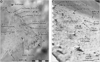
I put together a rock map for SLIM. It's only approximate but I think one or two of the largest rocks are just visible in the LRO images. If we get an OHRC image of this location, several of the rocks should be very clearly identifiable.
Phil
EDIT: I noticed that I had to rotate the lander 180 degrees on the map - I have replaced the map, so if you downloaded the old one, this is the one you really need. -------------------- ... because the Solar System ain't gonna map itself.
Also to be found posting similar content on https://mastodon.social/@PhilStooke Maps for download (free PD: https://upload.wikimedia.org/wikipedia/comm...Cartography.pdf NOTE: everything created by me which I post on UMSF is considered to be in the public domain (NOT CC, public domain) |
|
 |
 
|
|
|
Feb 16 2024, 01:01 AM
Post
#107
|
|
 Member Group: Members Posts: 890 Joined: 15-June 09 From: Lisbon, Portugal Member No.: 4824 |
A February 14 article in APNews, covering the analysis of rocks by SLIM and their implications for the Moon's origin theory, hints at the possibility of a reawakening in late February:
QUOTE SLIM is currently "hibernating" in another lunar night that will last till late February. It remains unknown if the probe and its spectroscope will survive the severe cold night temperatures and be able to "wake up" once sunlight returns. Link: https://apnews.com/article/japan-jaxa-moon-...480f8b6b9d5cd93 Fernando |
|
|
|
|
Feb 26 2024, 05:15 AM
Post
#108
|
|
|
Junior Member Group: Members Posts: 64 Joined: 15-June 12 From: Hong Kong Member No.: 6419 |
JAXA has announced they have managed to re-contact SLIM briefly yesterday, although only a brief contact was done due to high temperatures within the lander. They will continue contact in the coming days.
Twitter Link -------------------- UMSF - the place of Opportunity to satisfy your Spirit of Curiosity via Perseverance
|
|
|
|
|
Feb 28 2024, 07:25 AM
Post
#109
|
|
|
Solar System Cartographer Group: Members Posts: 10153 Joined: 5-April 05 From: Canada Member No.: 227 |
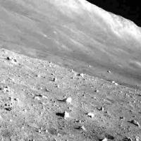
The navigation camera image from the brief contact with SLIM:
https://twitter.com/SLIM_JAXA/status/1762671786775490715 and the plan for the Multi-Band Camera in the next day or two: https://twitter.com/SLIM_JAXA/status/1762095220743930163 Phil -------------------- ... because the Solar System ain't gonna map itself.
Also to be found posting similar content on https://mastodon.social/@PhilStooke Maps for download (free PD: https://upload.wikimedia.org/wikipedia/comm...Cartography.pdf NOTE: everything created by me which I post on UMSF is considered to be in the public domain (NOT CC, public domain) |
|
|
|
|
Mar 1 2024, 08:05 PM
Post
#110
|
|
|
Solar System Cartographer Group: Members Posts: 10153 Joined: 5-April 05 From: Canada Member No.: 227 |
The second lunar day is now over. MBC did not operate so no new data were obtained from it in day 2. The navigation camera took the image linked in the last post and another just before sunset.
Phil https://twitter.com/SLIM_JAXA/status/1763516934333849705 -------------------- ... because the Solar System ain't gonna map itself.
Also to be found posting similar content on https://mastodon.social/@PhilStooke Maps for download (free PD: https://upload.wikimedia.org/wikipedia/comm...Cartography.pdf NOTE: everything created by me which I post on UMSF is considered to be in the public domain (NOT CC, public domain) |
|
|
|
|
Mar 28 2024, 03:49 AM
Post
#111
|
||
 Senior Member Group: Members Posts: 1421 Joined: 26-July 08 Member No.: 4270 |
SLIM woke up for a third lunar day. As before, it's rather warm so they aren't doing much. But they did get another camera shot of the same view we're all used to.
https://twitter.com/SLIM_JAXA/status/1773190431758508138 QUOTE According to the acquired data, some temperature sensors and unused battery cells are starting to malfunction, but the majority of functions that survived the first lunar night was mantained even after the second lunar night!
Attached thumbnail(s)
-------------------- -- Hungry4info (Sirius_Alpha)
|
|
|
|
|
|
|
Apr 1 2024, 03:05 AM
Post
#112
|
|
|
Solar System Cartographer Group: Members Posts: 10153 Joined: 5-April 05 From: Canada Member No.: 227 |
Here is a very nice new image from SLIM on its last day of operation during lunar day 3, with less shadow than seen during the previous late afternoon images.
https://twitter.com/SLIM_JAXA/status/1774608981098729732 Phil -------------------- ... because the Solar System ain't gonna map itself.
Also to be found posting similar content on https://mastodon.social/@PhilStooke Maps for download (free PD: https://upload.wikimedia.org/wikipedia/comm...Cartography.pdf NOTE: everything created by me which I post on UMSF is considered to be in the public domain (NOT CC, public domain) |
|
|
|
|
Apr 8 2024, 05:20 AM
Post
#113
|
|
|
Solar System Cartographer Group: Members Posts: 10153 Joined: 5-April 05 From: Canada Member No.: 227 |
https://twitter.com/SLIM_JAXA/status/1777186920650649997
Two very nice GIF representations of SLIM's NavCam images: chronological and by local time. Phil -------------------- ... because the Solar System ain't gonna map itself.
Also to be found posting similar content on https://mastodon.social/@PhilStooke Maps for download (free PD: https://upload.wikimedia.org/wikipedia/comm...Cartography.pdf NOTE: everything created by me which I post on UMSF is considered to be in the public domain (NOT CC, public domain) |
|
|
|
|
Apr 11 2024, 07:03 AM
Post
#114
|
|
|
Solar System Cartographer Group: Members Posts: 10153 Joined: 5-April 05 From: Canada Member No.: 227 |
Here is an excellent representation of the SLIM landing site with at one point an estimate of Sora-Q's location.
https://www.isas.jaxa.jp/home/slim/SLIM/ass...LandingSite.mp4 Phil -------------------- ... because the Solar System ain't gonna map itself.
Also to be found posting similar content on https://mastodon.social/@PhilStooke Maps for download (free PD: https://upload.wikimedia.org/wikipedia/comm...Cartography.pdf NOTE: everything created by me which I post on UMSF is considered to be in the public domain (NOT CC, public domain) |
|
|
|
|
Apr 24 2024, 02:34 AM
Post
#115
|
|
|
Senior Member Group: Members Posts: 1421 Joined: 26-July 08 Member No.: 4270 |
A fourth lunar Day and an image taken earlier in the day than before.
https://twitter.com/SLIM_JAXA/status/1782956426752848056 -------------------- -- Hungry4info (Sirius_Alpha)
|
|
|
|
|
Yesterday, 08:12 PM
Post
#116
|
||
|
Solar System Cartographer Group: Members Posts: 10153 Joined: 5-April 05 From: Canada Member No.: 227 |
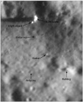
Here is a tweet from Chandra ( @this_is_tckb ) about finding SLIM in a new OHRC image (16 March 2024).
https://twitter.com/this_is_tckb/status/1783084056734789992 The image is very interesting. Its resolution is good enough to identify some of the rocks south of the SLIM lander. But there's a puzzle too. Immediately southwest of the lander is a bright spot which looks to be about 70 cm across and not very high (it casts a short shadow in this very early morning image). The LEV-2 image of the lander on the surface doesn't show anything on the ground there, though I think it should be visible. It is far too close to the lander to be the broken rocket nozzle. It could be a mostly buried rock or some object - maybe a bit of a solar panel or thermal blanket - which fell off the lander during its eventful landing. Could it be LEV-1? I don't think so but it might be possible. Phil
-------------------- ... because the Solar System ain't gonna map itself.
Also to be found posting similar content on https://mastodon.social/@PhilStooke Maps for download (free PD: https://upload.wikimedia.org/wikipedia/comm...Cartography.pdf NOTE: everything created by me which I post on UMSF is considered to be in the public domain (NOT CC, public domain) |
|
|
|
|
|
|
Yesterday, 08:34 PM
Post
#117
|
|
|
Senior Member Group: Members Posts: 1421 Joined: 26-July 08 Member No.: 4270 |
Could it be a reflection of sunlight off the lander onto the ground? How real is that shadow? We didn't see it in the LRO image.
-------------------- -- Hungry4info (Sirius_Alpha)
|
|
|
|
|
Yesterday, 09:25 PM
Post
#118
|
|
|
Solar System Cartographer Group: Members Posts: 10153 Joined: 5-April 05 From: Canada Member No.: 227 |
The only post-landing LRO image I have seen is taken with very high sun. There are several long shadows from rocks in the image. I don't see why it would not be real.
A light reflection... that's a good suggestion. We've seen that with (e.g) Yutu and Yutu 2. I'm not sure the geometry is right but I will think about it. Phil -------------------- ... because the Solar System ain't gonna map itself.
Also to be found posting similar content on https://mastodon.social/@PhilStooke Maps for download (free PD: https://upload.wikimedia.org/wikipedia/comm...Cartography.pdf NOTE: everything created by me which I post on UMSF is considered to be in the public domain (NOT CC, public domain) |
|
|
|
|
Today, 04:38 AM
Post
#119
|
|
|
Senior Member Group: Members Posts: 1421 Joined: 26-July 08 Member No.: 4270 |
QUOTE (Phil Stooke @ Apr 26 2024, 04:25 PM)  The only post-landing LRO image I have seen is taken with very high sun. There are several long shadows from rocks in the image. I don't see why it would not be real. My point about the LRO image is exactly that it had a difference in the solar illumination angle, which might affect the visibility/location/existence of reflections. I definitely agree though that it's not clear the geometry for a reflection makes a lot of sense. -------------------- -- Hungry4info (Sirius_Alpha)
|
|
|
|
|

|
Lo-Fi Version | Time is now: 27th April 2024 - 10:00 PM |
|
RULES AND GUIDELINES Please read the Forum Rules and Guidelines before posting. IMAGE COPYRIGHT |
OPINIONS AND MODERATION Opinions expressed on UnmannedSpaceflight.com are those of the individual posters and do not necessarily reflect the opinions of UnmannedSpaceflight.com or The Planetary Society. The all-volunteer UnmannedSpaceflight.com moderation team is wholly independent of The Planetary Society. The Planetary Society has no influence over decisions made by the UnmannedSpaceflight.com moderators. |
SUPPORT THE FORUM Unmannedspaceflight.com is funded by the Planetary Society. Please consider supporting our work and many other projects by donating to the Society or becoming a member. |
|