New mosaic map of Itokawa |

New mosaic map of Itokawa |
 Sep 9 2010, 03:06 PM Sep 9 2010, 03:06 PM
Post
#1
|
||
|
Solar System Cartographer  Group: Members Posts: 10151 Joined: 5-April 05 From: Canada Member No.: 227 |
Having a bit of time free I have embarked on a new global photomosaic map of asteroid 25143 Itokawa. Follow its construction here as I go. I'm hoping it won't take more than 4 to 6 weeks as other duties call. The mosaic will eventually go into PDS.
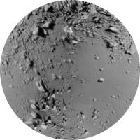
This follows the work I did on a map made from rendered images derived from Bob Gaskell's shape model. That had to be the first step because the control I'm using is derived from published lat-long grids superimposed on his rendered images. Now each individual image will be reprojected to fit that map. The large local relief will make it impossible to make all seams invisible, however. First step: the north polar area. The outer edge is at 40 N, with 90 N at the middle and 0 longitude at the top. Phil
-------------------- ... because the Solar System ain't gonna map itself.
Also to be found posting similar content on https://mastodon.social/@PhilStooke Maps for download (free PD: https://upload.wikimedia.org/wikipedia/comm...Cartography.pdf NOTE: everything created by me which I post on UMSF is considered to be in the public domain (NOT CC, public domain) |
|
 |
 
|
|
 |
|
Sep 23 2010, 09:09 PM
Post
#2
|
||
|
Solar System Cartographer Group: Members Posts: 10151 Joined: 5-April 05 From: Canada Member No.: 227 |
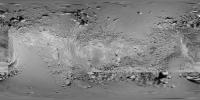
Here's an update to the Itokawa mosaic. I have added several images to the area on and north of the equator and around the 180 longitude region (middle of this map). The southern edge of that region will be next. Slow going, but it will gradually fill in. There will still be some further improvements to parts already done.
Phil
-------------------- ... because the Solar System ain't gonna map itself.
Also to be found posting similar content on https://mastodon.social/@PhilStooke Maps for download (free PD: https://upload.wikimedia.org/wikipedia/comm...Cartography.pdf NOTE: everything created by me which I post on UMSF is considered to be in the public domain (NOT CC, public domain) |
|
|
|
|
|
|
Sep 23 2010, 09:28 PM
Post
#3
|
|
|
Member Group: Members Posts: 140 Joined: 20-November 07 Member No.: 3967 |
Wow! That is a fine piece of work, Phil.
But, to digress, I'm finding a few discrepancies in the plastic model that JAXA made for me, and the location of various features (three prominent rocks, so not very many places) in your earlier map. One reason is that had to draw lat/longs on the model by hand and eye, so my constant-scale natural boundary map, we should expect, is not perfectly aligned with the lat/longs of features on the cylindrical map. But the curious thing is that the discrepancy is an almost perfect 10 degrees. I'll post a map later with the misalignments called out, but is it possible that there might be some projection anomalies, let's call them, in your initial projection? |
|
|
|
 Phil Stooke New mosaic map of Itokawa Sep 9 2010, 03:06 PM
 elakdawalla Yaaaay Phil! I can't wait to see this com... Sep 9 2010, 04:29 PM
 chuckclark QUOTE (elakdawalla @ Sep 9 2010, 12:29 PM... Sep 16 2010, 12:42 PM
 chuckclark QUOTE (elakdawalla @ Sep 9 2010, 11:29 AM... Sep 25 2010, 06:05 PM Phil Stooke Yes, it's Sagamihara.
Phil Sep 9 2010, 05:21 PM Phil Stooke ... and the south pole. Each of these polar maps ... Sep 9 2010, 08:30 PM elakdawalla OK, so that one shows MUSES-C regio. There should... Sep 9 2010, 08:44 PM Phil Stooke They should look circular on that map! But no... Sep 9 2010, 09:10 PM elakdawalla Sorry, I'll be patient I've just had thi... Sep 9 2010, 09:13 PM Phil Stooke Next step in the mosaic. I have added a section a... Sep 15 2010, 09:09 PM Juramike Thanks, Phil! It's really neat seeing the... Sep 15 2010, 11:07 PM Phil Stooke Will do!
Phil Sep 16 2010, 03:35 PM The Singing Badger What would be the surface area of Itokawa? I'm... Sep 16 2010, 05:05 PM djellison http://en.wikipedia.org/wiki/25143_Itokawa
Dimens... Sep 16 2010, 06:36 PM Eluchil QUOTE (djellison @ Sep 16 2010, 06:36 PM)... Sep 17 2010, 12:02 AM The Singing Badger Thank you!
So you could probably stroll arou... Sep 17 2010, 03:02 PM Phil Stooke Yes, you could walk (float) around the blasted thi... Sep 17 2010, 03:24 PM chuckclark Itokawa on Wembley, at least from my point of view... Sep 17 2010, 07:48 PM djellison Personally, I think the addition of an asteroid is... Sep 17 2010, 07:54 PM Phil Stooke Yes, let's have a look at the discrepancies. ... Sep 23 2010, 10:11 PM elakdawalla Thanks for labeling those, Chuck, and I feel much ... Sep 25 2010, 08:41 PM chuckclark happy to be of help. Sep 25 2010, 10:08 PM chuckclark Oh, by the way, here's how Itokawa scales onto... Sep 28 2010, 03:11 PM chuckclark Here is the (old) cylindrical map showing regio bo... Sep 28 2010, 07:41 PM Phil Stooke After a year-long hiatus I have returned to the It... Sep 2 2011, 05:25 PM chuckclark [quote name='Phil Stooke' date='Sep 2 ... Sep 2 2011, 06:13 PM Phil Stooke Current version of the mosaic - the worst remainin... Sep 8 2011, 09:17 PM Phil Stooke The global photomosaic map of Itokawa is almost fi... Oct 11 2011, 07:48 PM Phil Stooke The mosaic map of Itokawa will be available from P... May 29 2012, 08:53 PM chuckclark . . . new map projections for Itokawa and other el... May 29 2012, 09:26 PM jasedm Very nice Phil!
Itokawa is a bewildering litt... May 29 2012, 09:30 PM Explorer1 The early solar system was like a blizzard of rock... May 30 2012, 12:05 AM Phil Stooke "So is each individual ellipse a map of Itoka... May 30 2012, 01:59 AM chuckclark Each of these maps is of a 'hemisphere' .... May 30 2012, 02:05 AM Phil Stooke That's exactly right, Chuck.
Phil May 30 2012, 11:42 AM chuckclark That's exactly right, Chuck.
Phil
Good. Thank... May 30 2012, 01:57 PM Phil Stooke "it looks like the contact spot of two (paire... May 30 2012, 02:18 PM JohnVV ---edit--- Jun 3 2012, 08:41 AM Phil Stooke Maybe for Itokawa it needs to be a brick-shaped ma... Jun 3 2012, 03:51 PM Phil Stooke My photomosaic map of Itokawa is now available at ... May 24 2013, 03:58 AM Phil Stooke Resurrecting an old thread here to post what I sai... Apr 10 2014, 09:05 PM Phil Stooke And... for comparison, though it doesn't reall... Apr 10 2014, 09:06 PM Phil Stooke Another asteroid map comparison - no, it doesn... Sep 3 2014, 06:19 PM Phil Stooke Hot off the press, an experimental map of the nort... Oct 24 2014, 09:09 PM Phil Stooke I'll put this here even though it's not It... Feb 5 2015, 08:19 PM
chuckclark QUOTE (elakdawalla @ Sep 9 2010, 11:29 AM... Sep 25 2010, 06:05 PM Phil Stooke Yes, it's Sagamihara.
Phil Sep 9 2010, 05:21 PM Phil Stooke ... and the south pole. Each of these polar maps ... Sep 9 2010, 08:30 PM elakdawalla OK, so that one shows MUSES-C regio. There should... Sep 9 2010, 08:44 PM Phil Stooke They should look circular on that map! But no... Sep 9 2010, 09:10 PM elakdawalla Sorry, I'll be patient I've just had thi... Sep 9 2010, 09:13 PM Phil Stooke Next step in the mosaic. I have added a section a... Sep 15 2010, 09:09 PM Juramike Thanks, Phil! It's really neat seeing the... Sep 15 2010, 11:07 PM Phil Stooke Will do!
Phil Sep 16 2010, 03:35 PM The Singing Badger What would be the surface area of Itokawa? I'm... Sep 16 2010, 05:05 PM djellison http://en.wikipedia.org/wiki/25143_Itokawa
Dimens... Sep 16 2010, 06:36 PM Eluchil QUOTE (djellison @ Sep 16 2010, 06:36 PM)... Sep 17 2010, 12:02 AM The Singing Badger Thank you!
So you could probably stroll arou... Sep 17 2010, 03:02 PM Phil Stooke Yes, you could walk (float) around the blasted thi... Sep 17 2010, 03:24 PM chuckclark Itokawa on Wembley, at least from my point of view... Sep 17 2010, 07:48 PM djellison Personally, I think the addition of an asteroid is... Sep 17 2010, 07:54 PM Phil Stooke Yes, let's have a look at the discrepancies. ... Sep 23 2010, 10:11 PM elakdawalla Thanks for labeling those, Chuck, and I feel much ... Sep 25 2010, 08:41 PM chuckclark happy to be of help. Sep 25 2010, 10:08 PM chuckclark Oh, by the way, here's how Itokawa scales onto... Sep 28 2010, 03:11 PM chuckclark Here is the (old) cylindrical map showing regio bo... Sep 28 2010, 07:41 PM Phil Stooke After a year-long hiatus I have returned to the It... Sep 2 2011, 05:25 PM chuckclark [quote name='Phil Stooke' date='Sep 2 ... Sep 2 2011, 06:13 PM Phil Stooke Current version of the mosaic - the worst remainin... Sep 8 2011, 09:17 PM Phil Stooke The global photomosaic map of Itokawa is almost fi... Oct 11 2011, 07:48 PM Phil Stooke The mosaic map of Itokawa will be available from P... May 29 2012, 08:53 PM chuckclark . . . new map projections for Itokawa and other el... May 29 2012, 09:26 PM jasedm Very nice Phil!
Itokawa is a bewildering litt... May 29 2012, 09:30 PM Explorer1 The early solar system was like a blizzard of rock... May 30 2012, 12:05 AM Phil Stooke "So is each individual ellipse a map of Itoka... May 30 2012, 01:59 AM chuckclark Each of these maps is of a 'hemisphere' .... May 30 2012, 02:05 AM Phil Stooke That's exactly right, Chuck.
Phil May 30 2012, 11:42 AM chuckclark That's exactly right, Chuck.
Phil
Good. Thank... May 30 2012, 01:57 PM Phil Stooke "it looks like the contact spot of two (paire... May 30 2012, 02:18 PM JohnVV ---edit--- Jun 3 2012, 08:41 AM Phil Stooke Maybe for Itokawa it needs to be a brick-shaped ma... Jun 3 2012, 03:51 PM Phil Stooke My photomosaic map of Itokawa is now available at ... May 24 2013, 03:58 AM Phil Stooke Resurrecting an old thread here to post what I sai... Apr 10 2014, 09:05 PM Phil Stooke And... for comparison, though it doesn't reall... Apr 10 2014, 09:06 PM Phil Stooke Another asteroid map comparison - no, it doesn... Sep 3 2014, 06:19 PM Phil Stooke Hot off the press, an experimental map of the nort... Oct 24 2014, 09:09 PM Phil Stooke I'll put this here even though it's not It... Feb 5 2015, 08:19 PM |

|
Lo-Fi Version | Time is now: 26th April 2024 - 04:16 PM |
|
RULES AND GUIDELINES Please read the Forum Rules and Guidelines before posting. IMAGE COPYRIGHT |
OPINIONS AND MODERATION Opinions expressed on UnmannedSpaceflight.com are those of the individual posters and do not necessarily reflect the opinions of UnmannedSpaceflight.com or The Planetary Society. The all-volunteer UnmannedSpaceflight.com moderation team is wholly independent of The Planetary Society. The Planetary Society has no influence over decisions made by the UnmannedSpaceflight.com moderators. |
SUPPORT THE FORUM Unmannedspaceflight.com is funded by the Planetary Society. Please consider supporting our work and many other projects by donating to the Society or becoming a member. |
|