Printable Version of Topic
Click here to view this topic in its original format
Unmanned Spaceflight.com _ MSL _ MARDI images and videos
Posted by: Eluchil Aug 6 2012, 07:45 AM
There is a low bandwidth ODY pass that will happen in about 10 minutes that may have a couple new HazCams. Does anyone know when the first MARDI images are expected to be downlinked? I saw that 18 had been assigned a (relatively) high priority, but the JPL Ustream was just saying that the current pass would have only a HazCam or two.
Posted by: mcaplinger Aug 6 2012, 07:55 AM

We're not sure. Something could come down in this pass (thumbnails) but it could get bumped by higher-priority EDL data. Might have to wait for tomorrow morning's passes.
Posted by: PDP8E Aug 6 2012, 09:58 PM
If we see someone from Malin Space Science Systems on the panel at the next scheduled mission conference, then we can at least expect a solid update on Mardi; at most an actual peek at the data products. 
Posted by: MarsEngineer Aug 6 2012, 10:08 PM
Hi all,
Still sleepy (need nap), but I got an early glimpse of the planned MARDI thumbs. Worth staying up for.
Oh so cool. I can hardly wait for the movie. We will all get a feel for just what a wild ride this really is.
Mike Malin and his gang really know how to do this.
So really, I am ok about sending a robot through it (even one that has been fawned over by thousands of hands), but sending a person through these harrowing adventures is really not something I could stomach. I will leave that to the next gen.
POk so HGA deploy is later this sol. It is still only 7:20 am LST (3 pm PDT) and the rover won't wake for a couple of hours. (She has had a big day yesterday)
I think this is the rough plan for this sol morning - but don't hold me to it - all times are LST:
09:46 Wake-up
10:00 LGA DFE (direct command from earth)
10:50 LGA Beep (our first x band signal from the rover to earth !)
11:45 HGA Deploy (its pyros have already been fired but this is the first time we will have moved it and it is the first use of the RMCA)
(RMCA = rover motor control assembly ... a big box o FETs, FPGAs, RISC and other circuits with lots of wires coming out)
More adventures to come.
-Rob Manning
Posted by: MarsEngineer Aug 6 2012, 10:09 PM
just to be clear I do not know if the MARDI images will be shown at the 4 pm PDT press conf. They were very raw.
-Rob
Posted by: Marslauncher Aug 6 2012, 10:17 PM
-Rob
Thanks for the timeline for the HGA activities.
Congrats to the entire team again on a fantastic landing.
Posted by: Gladstoner Aug 6 2012, 10:22 PM
.
Posted by: punkboi Aug 6 2012, 10:44 PM

An IMAX film will be made with the MARDI footage? I guess this should make up for the zoom lens not being installed on Curiosity. Sorry James Cameron
Posted by: Gladstoner Aug 6 2012, 10:51 PM
.
Posted by: elakdawalla Aug 6 2012, 11:06 PM
From Nature journalist Eric Hand on Twitter: "Get ready for another wow: Looks like MARDI, the descent imager, caught the heat shield on the ground."
Posted by: Explorer1 Aug 6 2012, 11:07 PM
Started...
Posted by: Explorer1 Aug 6 2012, 11:14 PM
Hello heat shield!
Posted by: Marslauncher Aug 6 2012, 11:19 PM
So unbelievably freaking cool! well worth the wait!
Posted by: walfy Aug 6 2012, 11:23 PM
MALI pics!
Heat shield:
|
20 meters above, picking up dust:
|
Posted by: Explorer1 Aug 6 2012, 11:24 PM
WOW
Posted by: nprev Aug 6 2012, 11:25 PM
Oh, boy.
Name check for Doug!!!
Posted by: walfy Aug 6 2012, 11:25 PM
I think Mr. Malin stated the exact coordinates "to within a meter." Did anyone catch that?
Posted by: dvandorn Aug 6 2012, 11:26 PM
Oh. My. God.
-the other Doug
Posted by: dvandorn Aug 6 2012, 11:29 PM
It was the dust-blowing sequence that really blew me away. The rockets really kicked up a little maelstrom, there. I hope they weren't assuming that the body of the rover would protect the mast cams from blowing dust, cause it looks like Curiosity descended into a rather energetically blowing cloud of dust there at the end.
-the other Doug
Posted by: mcaplinger Aug 6 2012, 11:39 PM
The Mastcams are pointed toward the deck when the RSM is stowed, there's a protective lip on the deck all the way around the RSM instruments, and there are long sunshades in front of the lenses, so I think we're good. More dust than I was expecting, though, at least visually.
Posted by: Marslauncher Aug 6 2012, 11:55 PM
Here is the video...
http://www.youtube.com/watch?v=UcGMDXy-Y1I
Fantastic briefing that gave a great indication on the sols ahead.
John / Marslauncher
Posted by: MahFL Aug 6 2012, 11:56 PM
Yes he said that, so they know exactly where the rover is. He also said they can map it's position to with cm using the full res MARDI pictures.
Posted by: Doc Aug 7 2012, 12:04 AM
Though like he said there is really no reason to do that (other than to show off
)
Posted by: Syrinx Aug 7 2012, 12:04 AM
Seems like the thrusters cleared out the area under the rover. I would expect the ground texture outside the landing zone to be different, probably a finer dust with the larger pebbles just underneath the dust or slightly protruding.
Posted by: djellison Aug 7 2012, 12:47 AM
Turned the MARDI movie into an ANIM Gif at 4x the speed it was on NTV
Posted by: PDP8E Aug 7 2012, 12:53 AM
Sky Crane Works!!!
But that dust maelstrom at the end of MARDI animation was not what I expected!
wow!
Posted by: Paul Fjeld Aug 7 2012, 12:56 AM
That's really cool Doug! Once the powered flight starts you can really see the pitch down to get separation, then the pitch back up to null the rates, and then rock steady all the way down. Thanks!
Posted by: ZLD Aug 7 2012, 01:06 AM
Anyone working their magic for a motion interpolated version yet?
Posted by: nprev Aug 7 2012, 01:08 AM
Gotta say...this is just stupid insane shockmonkey bloody cool. (Yeah. That damn cool!)
Wow, you guys. Wow, Doug. We need a smiling exploding head icon, most def.
Posted by: Paul Fjeld Aug 7 2012, 01:26 AM
If you look at the last images from the MARDI, I think you see the left front wheel toed in "40ish" degrees. It looks a little more, but I'm guessing there are fish-eye effects.
Posted by: walfy Aug 7 2012, 05:58 AM
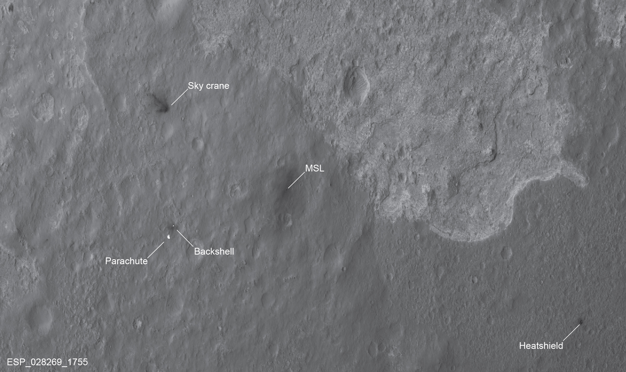
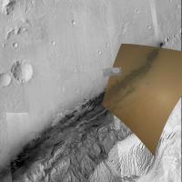
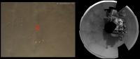
Here's a HiRISE/MARDI comparison. I was short on time, hence the sloppiness!
If you doubt the final guess at the three small craters just near the landing site, download the YouTube video of the descent sequence and scrub (play forward and reverse many times) that final sequence and you can't miss those three craters that stand out in triangle formation. The crater marking the top point of the triangle is where the initial blast of the thrusters hit. Then a few moments later the rover seems to hover just a bit just to the right of the crater marking the lower right point of the triangle. After which the crater quickly slips up and out of view just before touchdown. What a blast!
North is approx. to the left. EDIT: replaced original image with this corrected one:
|
Posted by: walfy Aug 7 2012, 06:03 AM
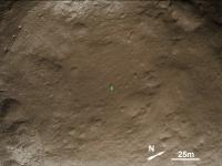
Based on my previous post, this is my humble best guess at Curiosity's location. The rover is Photoshopped in at approximately 11.5 pixels. (HiRISE webpage for the background image stated that it was 25 cm per pixel).
|
Posted by: volcanopele Aug 7 2012, 06:06 AM
Thank you, walfy, I was hoping someone would take a crack at that kind of analysis.
Posted by: um3k Aug 7 2012, 06:37 AM
Walfy, your first image is mismatched (possibly throwing off the ones that follow, as well). Here's a correction:
https://picasaweb.google.com/lh/photo/2Z-DfJB2u1JpuO_ZDXwOtdMTjNZETYmyPJy0liipFm0?feat=directlink
Posted by: Keatah Aug 7 2012, 06:41 AM
Regarding the amount of dust kicked up by the descent thrusters.. It seems to me more than expected. Or am I just "preconditioned" by the non-thruster-landings of Sojourner and MER A/B; which resulted in initial sterile-looking appearances. Did the amount surprise the folks back at MC?
Posted by: walfy Aug 7 2012, 07:35 AM
Wow, that was sloppy! Thanks for spotting that, and for the nice way of comparing all of it in B&W. I've changed http://www.unmannedspaceflight.com/index.php?act=attach&type=post&id=27321, updated my previous post. I'm still pretty sure the lower right crater in the triangle was the one which was nearly hovered over momentarily.
Posted by: DanielL Aug 7 2012, 10:41 AM
Hello, I hope this is the correct thread - am posting in this one as I noticed previous discussion of the descent sequence imagery here. I'm wondering how much info could be derived about the MSL's hazard avoidance strategies from the sequence? I would suppose quite a lot - even as a non-expert I can see some horizontal motion ... wondering specifically about MSL's ability to choose the best landing spot. I realize the terrain is pretty benign already, but closer to the surface there must have must been some hazard avoidance? - BTW elsewhere, someone has also asked about the video indicating the descent stage shifting away from the parachute after separation, but I'm assuming the camera was only turned on after that separation?
Thanks and regards,
Daniel
Posted by: jamescanvin Aug 7 2012, 10:46 AM
No, MSL had no ability to perform hazard avoidance for surface features. The only hazard avoidance manoeuvre was just after release from the backshell when a horizontal manoeuvre was performed to remove any risk of recontacting the backshell/parachute.
Posted by: DanielL Aug 7 2012, 10:56 AM
Thanks James - so then, would any horizontal motions in the video be from other causes, for instance the descent stage moving to stabilize the rover? (compensating for pendulum motion for instance?)
Posted by: jmknapp Aug 7 2012, 11:02 AM
During the landing the EDL commentator said "we found a nice flat place, we're coming in ready for skycrane" (around 28:17 in http://www.space-multimedia.nl.eu.org/index.php?option=com_content&view=article&id=7757:mars-science-laboratorycuriosity-rover-landing&catid=1:latest). I wonder what he meant by that--that they just passively found a nice flat place? By what means did they get a measure of the flatness?
Posted by: Eluchil Aug 7 2012, 11:04 AM
Daniel
No the MARDI (Descent Imager) began taking pictures just before the heat shield was jettisoned during the parachute phase of the descent. See http://www.planetary.org/blogs/emily-lakdawalla/2012/06290700-how-curiosity-land-part-2.html and the other resources linked in the FAQ thread at the top of this forum for a complete timeline of EDL events. I can't really tell which motion in the descent image video is caused by the divert maneuver. The noticeable movement at about 18 seconds into the video seems more twisting than anything else.
Posted by: DanielL Aug 7 2012, 11:15 AM
Thanks ...
Posted by: Oersted Aug 7 2012, 11:24 AM
http://www.youtube.com/watch?v=UcGMDXy-Y1I
I would have preferred a version at the correct speed. This one shows the last 2 and a half minutes of descent, yet lasts only about one minute.
Looking forward to the full-size version with perhaps even some interpolated, generated images.
Posted by: elakdawalla Aug 8 2012, 01:58 AM
Geez, the http://mars.jpl.nasa.gov/msl/multimedia/raw/?s=0 for hours. Are you guys asleep at the wheel? Where's the image magery? 
Posted by: James Sorenson Aug 8 2012, 02:03 AM
Wowwzers!! Thanks Emily!
http://mars.jpl.nasa.gov/msl-raw-images/msss/00000/mrdi/0000MD9999000072E1_DXXX.jpg
Posted by: Big Joe Aug 8 2012, 02:04 AM
I thought the same thing figured by now we would have a video posted :-)
Posted by: mhoward Aug 8 2012, 02:14 AM
Ha! Folks aren't used to the new website yet. (Myself included.)
Posted by: Reed Aug 8 2012, 02:49 AM
Unless I'm missing something, we can use the MARDI image timestamps to resolve the question of when the first haz images were taken relative to touchdown:
http://mars.jpl.nasa.gov/msl/multimedia/raw/?rawid=0000MD9999000688I1_DXXX&s=0 looks like about the first MARDI on the ground at 05:18:16
The haz images with the putative impact cloud are at 05:18:38
Seems about right to me.
Posted by: mcaplinger Aug 8 2012, 02:58 AM
In all fairness, there's only so much you can do with the thumbnails, the real magic will start when all of the full frames are back.
Posted by: elakdawalla Aug 8 2012, 03:20 AM
You're right, of course. But the little things we can do are interesting, until we get the big ones. Play with how they nest; try out a "real-time" animation; fiddle with colors/contrast; etc. Has anybody overlaid the MARDI frames on a CTX image yet?
Posted by: Tom Tamlyn Aug 8 2012, 04:08 AM
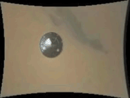
For "just thumbnails," some of the MARDI mages are nonetheless jaw-dropping. E.g.:
http://mars.jpl.nasa.gov/msl-raw-images/msss/00000/mrdi/0000MD9999000072E1_DXXX.jpg
I'm having trouble processing how much better the full images will be.
TTT (And of course, once we've seen the full images, we'll start to take them for granted ...)
Posted by: elakdawalla Aug 8 2012, 04:28 AM
I had the same question. We'll have to see adjacent frames to learn anything else about it, I think.
TTT: That one (and only that one) is full-resolution.
Posted by: malgar Aug 8 2012, 07:09 AM
A very simple elaboration
|
Posted by: RoverDriver Aug 8 2012, 07:32 AM
Malgar, that highlights the opposition effect quite clearly!
Paolo
Posted by: Tom Tamlyn Aug 8 2012, 08:10 AM
Thanks Emily! Glad to have http://www.unmannedspaceflight.com/index.php?s=&showtopic=7397&view=findpost&p=187602 corrected, because thinking of that image as a thumbnail was throwing my sense of scale way off.
TTT (Also kicking myself a bit. Curious whether the image was in fact a thumbnail, and mindful of Forum Rules 2.2 & 2.3, I did, prior to posting, do a quick scan of the Sol 0 index page for Raw MARDI images. I concluded that, since I hadn't noticed any image that wasn't labeled "thumbnail," the image in question must be a thumbnail. The checking procedure is now exposed as defective both in design and in execution; I'll try harder next time.)
Posted by: Oersted Aug 8 2012, 08:25 AM
Paolo
So we are sure it is not Heiligenschein from dew on the surface? :-)
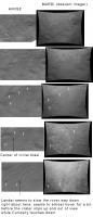
Posted by: ToSeek Aug 8 2012, 02:07 PM
Think if you drop a line straight down from the heat shield almost to the bottom of the image and then go a little bit to the right, that's where the landing site is.
This is your image cropped to that area and rotated so north is (approximately) up:
|
That puts the landing site just inside the left-hand edge of the image toward the middle.
Compare the HiRISE image:
In both of them there's a depressed area with a seed/diamond-shaped crater in it to the northeast, and Curiosity is just a little southwest of that.
Posted by: Astro0 Aug 8 2012, 02:43 PM
Tried matching up the full MARDI frame that was available and the HiRise image of the landing/impact sites with a larger context image of the overall landing/exploration area.
|
A larger version http://astro0.files.wordpress.com/2012/08/gale_context.jpg 9.4mb
Posted by: Doc Aug 8 2012, 03:03 PM
That looks pretty good there Astro.
Posted by: walfy Aug 8 2012, 04:02 PM
|
|
A larger version http://astro0.files.wordpress.com/2012/08/gale_context.jpg 9.4mb
This is awesome! Thanks!
And thank you to all the rest for posting these incredible new images!
Posted by: elakdawalla Aug 8 2012, 04:41 PM
That's cool. I'm surprised the MARDI frame is so far over the dunes & mountain. I guess that's because the rover was still descending at an angle when those first frames were taken, right?
Posted by: Barnard Aug 8 2012, 07:39 PM

Wow!
Posted by: KrisK Aug 9 2012, 12:50 AM
I wget all the MARDI thumbnails from just before heat shield sep until DS flyaway. Below is 5 fps video:
http://www.youtube.com/watch?v=DDwbc1dXsj0
Posted by: lyford Aug 9 2012, 02:04 AM
http://www.youtube.com/watch?v=DDwbc1dXsj0
Wow what a ride all the way down!
Posted by: elakdawalla Aug 9 2012, 02:07 AM
http://www.youtube.com/watch?v=DDwbc1dXsj0
Where did you wget them from?
Posted by: MizarKey Aug 9 2012, 02:10 AM
http://www.youtube.com/watch?v=DDwbc1dXsj0
Nicely done! What a fun ride.
Posted by: Josh Cryer Aug 9 2012, 03:00 AM
It looks like all the images are not yet showing up on the http://mars.jpl.nasa.gov/msl/multimedia/raw/?s=0.
But you can get them by http://mars.jpl.nasa.gov/msl-raw-images/msss/00000/mrdi/0000MD9999000001I1_DXXX.jpg and adding 1 to the number ending at "I1_DXXX.jpg"
edit: looks like it doesn't start getting interesting until http://mars.jpl.nasa.gov/msl-raw-images/msss/00000/mrdi/0000MD9999000026I1_DXXX.jpg, just to save anyone time who wants to do this.
Posted by: eoincampbell Aug 9 2012, 03:23 AM
I wonder if we'll get to see the heatsheild impact from Hi Res MARDI...
Posted by: elakdawalla Aug 9 2012, 03:27 AM
 Holy wakka-mole...
Posted by: brellis Aug 9 2012, 03:29 AM
KrisK - what a ride! wow!
Posted by: fredk Aug 9 2012, 04:02 AM
Here's the last frame down so far that I can see the heatshield in:
http://mars.jpl.nasa.gov/msl-raw-images/msss/00000/mrdi/0000MD9999000200E1_DXXX.jpg
(white speck over dunefield at upper left.)
Fantastic stuff - now I can't wait for the full colour bit depth!
Posted by: elakdawalla Aug 9 2012, 04:51 AM
As I've done with past missions, I'm planning to produce some web pages that will help me and you browse these data sets better. I do this through manipulating the source html of the web pages in Excel, a process that would no doubt cause all the real programmers here to cackle with derision. Anyway, I'm wondering what form these pages should take that would be most useful for people.
As a start, here's an Excel file containing URLs and timestamps of all MARDI frames downlinked to date, including the 18 full res ones.
(Note: change the extension from .zip to .xlsx in order to open)

Posted by: KrisK Aug 9 2012, 06:35 AM
From here: http://mars.jpl.nasa.gov/msl/multimedia/raw/?s=0 (scroll to bottom). When I was downloading them they all were loaded on the server but not linked. Now I can see that they linked most of the files. The file name goes from 0000MD9999000001I1_DXXX.jpg to at least (did not check max number) 0000MD9999001442I1_DXXX.jpg
Posted by: jekbradbury Aug 10 2012, 02:54 PM
What sort of de-Bayer processing is applied to the MARDI images? Attached is a gif of full -> only odd rows -> only even rows for a portion of 0000MD9999000512E1_DXXX.jpg:
|
It looks like the combination of Bayer issues and jpeg compression is producing artifacts, or something like that.
Posted by: craigmcg Aug 10 2012, 03:07 PM
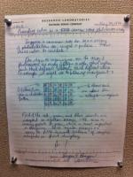
Since there has been some discussion of the Bayer filter here, I thought some of you would enjoy this. A copy of Bryce Bayer's lab notebook.
|
Posted by: mcaplinger Aug 10 2012, 04:11 PM
google for "interline image sensor smear". Only likely to be an issue for very short exposure times.
Posted by: James Sorenson Aug 10 2012, 04:17 PM
I was going to wait until the full frame images to do this, but here is my take on the MARDI thumbnail video. The audio timing with the MARDI images is pretty crude, but I think I got pretty close .
http://www.youtube.com/watch?v=59Id3YLIFXs&feature
Posted by: ZLD Aug 10 2012, 07:18 PM
As more and more MARDI images come down I keep seeing this bright patch come and go. At first I thought it might be some random artifact or something of processing but it moves, disappears and reappears in many of the frames. Anyone have any ideas? High altitude ice particles reflecting the sun? Strangely, it seems to follow the heat shield as it falls away, then it disappears out of frame and comes back after the heat shield is no longer resolvable. Strange.
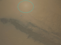
|
Lastly, I just want to say how great the color images are looking. Maybe it is just my imagination but the soil here looks far more intriguing than elsewhere we've seen insofar.
Posted by: ugordan Aug 10 2012, 07:27 PM
ZLD, you're seeing the opposition effect on the ground, that's the antisolar point.
Posted by: mcaplinger Aug 10 2012, 07:29 PM
That's the zero phase spot (point on the ground on a line between the camera and the sun) on the ground. See also "opposition effect". [ugordon beat me to it.]
Posted by: ZLD Aug 10 2012, 07:29 PM
I wondered that, just didn't expect it to be so reflective I guess.
Posted by: Jam Butty Aug 10 2012, 08:01 PM
Been meaning to de-lurk for a few days now just to say how awesome this all is, but to be honest I'm still pretty speechless.
Anyway, here is my humble contribution
|
MARDI image (http://mars.jpl.nasa.gov/msl-raw-images/msss/00000/mrdi/0000MD9999000512E1_DXXX.jpg),
processed to bring out the landing site features a bit better. The rover is shown roughly to scale by the green rectangle in the centre.
Looks like there might be an area of exposed layered 'bedrock' about 100m to the south.
Posted by: Bjorn Jonsson Aug 11 2012, 12:48 AM
As others have pointed out this is the opposition highlight and in fact it is also obvious in images obtained on the ground. It's particularly obvious in the Navcam panorama - the brightest parts of the panorama are near the mast's shadow.
Posted by: jmknapp Aug 11 2012, 01:04 AM
It was about 3 in the afternoon though. Does it make sense that the sun would be behind the downward-pointing camera?
Posted by: Bjorn Jonsson Aug 11 2012, 01:32 AM
Well, MARDI has a wide field of view (90 degrees) and wasn't always pointed exactly down (Curiosity dangling a bit below the parachute plus the fact that it wasn't falling straight down - there was a horizontal component as well).
Posted by: jmknapp Aug 11 2012, 02:18 AM
Sun elevation at landing, FWIW, was 34°.
Posted by: mcaplinger Aug 11 2012, 04:11 AM
On the chute the spacecraft (and the camera) wasn't pointing down, it was pointing more or less in the anti-sun direction. It only goes vertical later in the descent.
The MARDI FOV is 71x53 degrees.
Posted by: charleski Aug 12 2012, 11:04 AM
The full EDL data is only going to come down in a few weeks, but since I'm impatient, I decided to try to map the field of view shown in the MARDI thumbnails to the underlying Martian terrain. This is very, very rough and there are numerous problems with it, but I suppose someone might find it mildly interesting.
The thumbnails were obtained from the raw images section of the NASA-JPL site and have not been corrected either for distortion or projection. Looking back I suppose I could have tried to split out the video that was released with distortion-corrected frames, though those would have additional compression artifacts.
There's a lot of jitter in the frames. At one point I tried to smooth out the movement of features, but this just resulted in ugly systematic errors creeping in, so I decided it was more honest to leave the jitter as an expression of the uncertainty involved.
This mapping shows the field of view of the camera, so cannot be directly related to the vehicle's position without the IMU data and some of the movement seen will be the result of attitude adjustments. We can clearly see the final stage of Wrist Control Mode (the large turn made in the beginning). The movement to the east at 1:00 might be related to backshell separation, and I think the divert manouevre probably starts at 1:15. I'm not sure what caused the final movement beginning around 1:38, possibly an attitude adjustment. This, of course, is all speculation.
http://www.youtube.com/watch?v=gnUGUBzEO5Q
Posted by: Skyrunner Aug 12 2012, 11:10 AM
http://www.youtube.com/watch?v=gnUGUBzEO5Q
Wow...love that Charleski. Well done. That's just mesmerizing
Posted by: Nix Aug 12 2012, 11:29 AM
Very neat
Posted by: elakdawalla Aug 12 2012, 03:07 PM
This is something I've been wishing I had time to attempt -- thank you for sharing it!
Posted by: climber Aug 14 2012, 02:52 PM
I'm interested to know which frame of MARDI video would be the most urgent to download from Curiosity in order to help planning the begining of the route.
The frames can be blured by the movments during descent but pending they are looking strait down and the max definition is achieved, I was thinking of the following:
1- when quality equal HirIse (2 kms altitude)
2- twice better (1.320 km altitude)
3- 3 times better (660m altitude)
I then calculate the FOV and get this:
1- 2400m x 1800m (it's what I found here: http://msl-scicorner.jpl.nasa.gov/Instruments/MARDI/)
2- 1584m x 1188m
3- 792m x 984m
I'm wondering what do you think about this?
My opinion is that, with such FOV, the terrain around where we landed look so benign that I don't think MARDI pictures will be of any (real) help for route planning to get to the base of Mt Sharp.
Nevertheless MARDI will help for, say, the first 500m.
Posted by: RoverDriver Aug 14 2012, 04:03 PM
The frames can be blured by the movments during descent but pending they are looking strait down and the max definition is achieved, I was thinking of the following:
1- when quality equal HirIse (2 kms altitude)
2- twice better (1.320 km altitude)
3- 3 times better (660m altitude)
I then calculate the FOV and get this:
1- 2400m x 1800m (it's what I found here: http://msl-scicorner.jpl.nasa.gov/Instruments/MARDI/)
2- 1584m x 1188m
3- 792m x 984m
I'm wondering what do you think about this?
My opinion is that, with such FOV, the terrain around where we landed look so benign that I don't think MARDI pictures will be of any (real) help for route planning to get to the base of Mt Sharp.
Nevertheless MARDI will help for, say, the first 500m.
You can gauge which MARDI image has the spatial resolution you are looking for by comparing easily discernible features and compare their size to HiRISE. There might be some distortion due to vehicle attitude, but you should be mostly OK. Looking at HiRISE and MARDI I could not find anything weird except a tiny, easily avoidable, scarp at about 200 m to the east of the rover. Slopes are pretty benign in this neighborhood as well. If anyone sees anything I missed, please smack me in the head and drop me a line

Paolo
Posted by: dvandorn Aug 14 2012, 05:30 PM
So, they said they're going to get the rest of the full-res MARDI pictures back this Sol? I'm really, really looking forward to seeing the entire descent film in high-res.
One thing, though. At least in the thumbnail version of the film, it was not extremely obvious what camera movements corresponded with major events, such as release from backshell, avoidance maneuver, etc. Does anyone have any ideas on how the full-res movie could be annotated to indicate these landmarks?
-the other Doug
Posted by: chris Aug 14 2012, 05:35 PM
-the other Doug
I think another version of what charelski did the other day http://www.unmannedspaceflight.com/index.php?s=&showtopic=7397&view=findpost&p=188279 would work very well.
Chris
Posted by: dvandorn Aug 14 2012, 05:47 PM
Well, seeing a few full-res frames showing up in the MARDI collection from Sol 0 on the raw images pages. I checked last night and only found the one full-res image, of the heat shield shortly after release, that's been there for about a week. I just found two more full-res images, and more seem to be posting as we speak (after I found the first new one, I refreshed and the positions of the images changed, showing addition of new images, and then I found a second new one).
-the other Doug
Quick edit -- now there are at least four new full-res pics, more coming in. Links to a few of them:
http://mars.jpl.nasa.gov/msl-raw-images/msss/00000/mrdi/0000MD9999000124E1_DXXX.jpg
http://mars.jpl.nasa.gov/msl-raw-images/msss/00000/mrdi/0000MD9999000200E1_DXXX.jpg
http://mars.jpl.nasa.gov/msl-raw-images/msss/00000/mrdi/0000MD9999000256E1_DXXX.jpg
Posted by: djellison Aug 14 2012, 05:56 PM
That would be news to me. It's going to take a few weeks to get the whole thing.
They're working on something exactly like that right now.
D
Posted by: Explorer1 Aug 14 2012, 05:57 PM
Yeah, everything had timestamps, right? So it should be trivial.
Posted by: dvandorn Aug 14 2012, 06:00 PM
That's what I thought Mike Malin said, too, but what I *thought* I heard early in the telecon was "we're going to be getting the rest of those pictures out of the camera today." I definitely could have mis-heard, or the speaker could have mis-spoken. But I do note that high-res MARDI images are beginning to flow into the raw images page.
-the other Doug
Posted by: djellison Aug 14 2012, 06:04 PM
Out of the camera doesn't mean on the ground. They have to be pulled from the cameras own memory to the rover before getting downlinked.
And are you sure they were talking about MARDI and not the rest of the MastCam mosaic?
Posted by: dvandorn Aug 14 2012, 06:10 PM
Yep, the speaker quoted Mike Malin's comment from when the original thumbnail film was released that they can't just take the memory stick out of MARDI and put it into the Rover's main computer, so yeah, the discussion was specifically about the MARDI images.
Really good point about the difference between getting them out of the camera and getting them back down to Earth, though. Thanks. The new full-res images that are popping up are really whetting my appetite, though...
-the other Doug
Posted by: Floyd Aug 14 2012, 06:11 PM
At end of questions someone asked about MARDI--it will be couple of weeks for all images to come down.
On the audio, the trick was to hit the play button one you clicked on the link.
Posted by: Brian Lynch Aug 14 2012, 09:11 PM
This is my first post at UMSF, after following the discussions with great interest I am pleased to join and hope that my contributions meet the impressive SNR of the forum!
One thing, though. At least in the thumbnail version of the film, it was not extremely obvious what camera movements corresponded with major events, such as release from backshell, avoidance maneuver, etc. Does anyone have any ideas on how the full-res movie could be annotated to indicate these landmarks?
-the other Doug
I've been trying to put together a detailed video of the descent from the MARDI thumbnails. Patrick Blau at http://www.spaceflight101.com has provided a detailed timeline of the events, which I have fused with my own estimates from the raw images to produce a video. The time index of the thumbnails is rounded to the nearest second, so the actual time at each frame may not be exact, but the frame rate is calculated to be about 3.9 fps (818 frames in 209 seconds). Here is a link to the video, which is shown at 15 fps:
http://youtu.be/CZpdP-xdDmU
Heat shield separation is quoted as occurring at 05:15:24.6 but the MARDI imagery suggests approximately 05:15:28. Therefore, my timeline is shifted by that difference for all of the events. The images also suggest that backshell separation occurs at approximately 05:17:07, where there is an abrupt change from the wrist mode dynamics to steady controlled flight.
I have also put together the same video in real-time with the mission control audio included. This was difficult to align since many of the events were not announced at the exact time they occurred, but it adds some excitement (if you didn't already find the MARDI descent video exciting enough!). Note that I've aligned the audio to match the backshell separation but the timing could probably be improved (perhaps where the constant velocity accordion is stated as nominal would be a better reference point).
http://youtu.be/jV1fIPr-fh4
Brian
Posted by: helvick Aug 14 2012, 09:27 PM
Awesome first post - the real time movie synced to the audio just makes me want to cheer for the landing all over again.
Posted by: dvandorn Aug 14 2012, 09:46 PM
Very helpful and well-done, Brian. Thank you very much. It's extremely useful to see the milestones as they pass during the descent.
Looking forward to seeing this kind of thing with the high-res images.
-the other Doug
Posted by: elakdawalla Aug 14 2012, 10:00 PM
Aaand that video went straight to the blog Seriously Brian, that's one of the best first posts I've seen. Welcome! About the only thing that could improve it would be to put it on top of a video of the sort http://www.unmannedspaceflight.com/index.php?showtopic=7397&view=findpost&p=188279, with the MARDI images projected onto a HiRISE image of the landing site that enlarges as the rover descends.
Posted by: Roby72 Aug 14 2012, 10:12 PM
Seriously Brian, that's one of the best first posts I've seen. Welcome! About the only thing that could improve it would be to put it on top of a video of the sort http://www.unmannedspaceflight.com/index.php?s=&showtopic=7397&view=findpost&p=188290, with the MARDI images projected onto a HiRISE image of the landing site that enlarges as the rover descends.Emily I think you mean the post 953 from Charleski ?
http://www.unmannedspaceflight.com/index.php?showtopic=7397&view=findpost&p=188279
Rob
Posted by: Astro0 Aug 14 2012, 11:23 PM
Bryan, great http://www.unmannedspaceflight.com/index.php?showtopic=7397&view=findpost&p=188595. Sent shivers down my spine AGAIN!
Something in the audio caught my ear. Just after touchdown, the call goes out: "Time to see where our Curiosity takes us." Love it!
Posted by: DeanM Aug 14 2012, 11:31 PM
I know this is well past the event, but I haven't been able to identify the meaning of "constant velocity accordion".
Any clues?!
Dean
Posted by: Pando Aug 15 2012, 12:01 AM
This link should explain what a CV accordion is:
http://www.planetaryprobe.eu/IPPW7/proceedings/IPPW7%20Proceedings/Presentations/Session3/pr508.pdf
It's a method for correcting the altitude and velocity errors during certain descent stages.
Posted by: elakdawalla Aug 15 2012, 12:03 AM
Read the JPL engineers' article about EDL ( http://trs-new.jpl.nasa.gov/dspace/bitstream/2014/41708/1/08-0255.pdf ) and you'll find it in there. Basically, it's a period in the landing where the descent stage was commanded to cover a distance at constant velocity, but that distance that wasn't precisely known or programmable because it depended on how far they descended during the parachute descent. It could have been as short as zero.
Posted by: MahFL Aug 15 2012, 12:08 AM
Any clues?!
Dean
This link explains it. Basically it the short period where the DS figures out the actual height left to descend and gets to the real 50 m above the surface point with a deceleration of 20 m/s. Then it starts the next phase.
http://books.google.com/books?id=996m2ioeRn0C&pg=PA895&lpg=PA895&dq=constant+velocity+accordion&source=bl&ots=XltMCnRg5r&sig=ye3kskmVSSNAMwQQgB0DzdowQ-M&hl=en&sa=X&ei=h-YqULH4DYKk8ATvu4HADQ&sqi=2&ved=0CFAQ6AEwCQ#v=onepage&q=constant%20velocity%20accordion&f=false
Posted by: DeanM Aug 15 2012, 12:24 AM
Constant velocity accordion:
Very many thanks to all: I now understand that this is a means to address or absorb uncertainties in terms of duration of specific events.
The phrase 'accordion' is used to describe expansion or contraction in time - that's what had me scratching my head earlier - previously, I thought it was some kind of mechanical contraption.
"For errors which are not handled in the accordions, the system shows graceful degradation" [my bold].
What a dellightful description!
Dean
Posted by: craigmcg Aug 15 2012, 01:22 AM
The only other thing I would add (beyond the hi-res) is the altitude. Nice job Brian.
Posted by: Brian Lynch Aug 15 2012, 01:55 AM
Thanks for all the great feedback, everyone. I'm constantly checking the raw image page for Sol 0 hoping to get the 'full' MARDI images so I can make a hi-res version.
That video is great, and I would love to include it. Perhaps Charleski could send me his original frames?
I would also like to include parameters like altitude, velocity, attitude, etc., but I'm not sure if they have been made available. I'm looking at the JPL HORIZONS system right now so maybe I can at least compute the estimated altitude and velocity, a height map of the landing site would really help as well.
Posted by: ZefleR Aug 15 2012, 04:27 AM
Great work. Can I suggest if motivation permits. Including another picture in picture of the EDL animation in sync with the audio and timeline ? bit much?
Again great job!
Gary
Posted by: Explorer1 Aug 15 2012, 04:56 AM
Brian, were you inspired by this by any chance?
http://sci.esa.int/science-e/www/object/index.cfm?fobjectid=39219
Obviously, a load more instruments turned on in that EDL, but it was the first thing that came to my mind when I saw it.
Fantastic work!
Posted by: Brian Lynch Aug 15 2012, 05:06 AM
That is a good idea, I will try to sync the animation.
http://sci.esa.int/science-e/www/object/index.cfm?fobjectid=39219
Yes, actually
That video makes my jaw drop everytime.
Posted by: charleski Aug 15 2012, 10:51 AM
As I messaged to Brian, the more I look at my video the more problems I can see with it, but if anyone wants to play around with it, the Photoshop file I made is here (158MB):
https://skydrive.live.com/redir?resid=4D780E5632B47197!118
This only uses the frames that were initially released, so skips about 25% of them (I think the full set only appeared a couple of days later, but by then I'd already started tinkering), but the layers are named by file, which should allow identification.
I'll probably redo this once the full res images come down, though that will take some time.
Charles
Posted by: Brian Lynch Aug 15 2012, 11:49 AM
This is a very nice overlay:
A larger version http://astro0.files.wordpress.com/2012/08/gale_context.jpg 9.4mb
Would it be possible to apply the same kind of transformation for each MARDI image? Although I assume you would need to use the full resolution images.
...I don't think my image processing knowledge is quite as extensive as yours, Astro0.
Posted by: Lightning Aug 15 2012, 12:18 PM
Posted by: jmknapp Aug 15 2012, 12:37 PM
Some post-landing ones have come in this morning, for example:
http://mars.jpl.nasa.gov/msl-raw-images/msss/00000/mrdi/0000MD9999001070E1_DXXX.jpg
Now, that's some navel-gazing!
Posted by: charleski Aug 15 2012, 12:48 PM
Nothing so fancy
. Once I'd laid down the base terrain images (large one from Google Mars, inset from the HiRiSE image showing the landing hardware, matched to GM as closely as possible) I painted in some of the prominent features on a couple of layers at a low opacity, then used those as an overlay to scale, rotate and translate the MARDI images individually, trying to find a match for three features in each frame (not always possible). I started out trying to match the frames to each other to produce a smooth transition, but had to throw all that out as it produced systematic errors that ended up with the frames far out of position.To do this properly you really need to correct for distortion and projection, as http://www.unmannedspaceflight.com/index.php?showtopic=7397&view=findpost&p=187705 did. While we could approximate the required barrel correction by looking at the frames in the distortion-corrected movie that was released, it's not practical to try to project hundreds of frames by hand. We'd need the attitude data from the IMU once it comes down.
Posted by: Big Joe Aug 15 2012, 06:27 PM
Some more MARDI images are available now, did a quick stitch of the area.
http://www.flickr.com/photos/fxmurphy/7789855924/sizes/o/
Posted by: elakdawalla Aug 15 2012, 06:47 PM
Nice. I was looking at those new MARDI full frames (which I noticed thanks to jmknapp's MSL raw image table) and I was thinking it'd be fun to try to stitch them but leave in the stitch all the views of the heat shield as it fell, in the spirit of the "http://mars.jpl.nasa.gov/MPF/ames/ames-rovers.html" Pathfinder panorama. I don't have time to try though, so I throw the idea out there in case anybody wants to take it and run with it
Posted by: Nix Aug 15 2012, 07:05 PM
I have been thinking about something like that too, with the heatshield.. I hesitate to give it a try though 
Anyways not until everything is down in fullres..
Posted by: pmetschan Aug 15 2012, 07:28 PM
Anyways not until everything is down in fullres..
My apologies if someone has already done this but I was hoping you could all check me on this? I took one of the MARDI images that seemed fairly close to touchdown to see if I could locate Curiosity in it using the NAVCAM pano. This is the only frame that is fairly dust free (before MLE blowout) and low elevation that has been released thus far. Could you all take a look and let me know if that position looks correct?
I was going to attempt to actually scale and place the rover in the image but due to the fisheye I am a little uncertain about how it would scale in there. Either way if i am correct we should see a rock just under our back right/middle wheel after we move?
|
Posted by: Big Joe Aug 16 2012, 01:02 AM
Here is my attempt with stacking the full res images currently available from MARDI and the heat shield dropping away. I tried to keep the position of the heat shield true to each frame but where portions of the shield were hidden I moved them a bit.
http://www.flickr.com/photos/fxmurphy/7792044354/sizes/l/
Posted by: DeanM Aug 16 2012, 01:28 AM
Nice work, Joe!
The heat shield appears remarkably stable, even in 1 % of Earth's atmosphere - I expected at least some tumbling.
Next time JPL/NASA do this, perhaps they could put a camera on the inside of the heat shield & transmit images to the rover - that would make for great viewing of the underside of the lander descending under 'chute.
Dean
Posted by: nprev Aug 16 2012, 01:32 AM
Extremely unlikely, Dean. Added complexity means added risk, so 'heatshield cams' would have to have a VERY useful mission-related purpose besides the cool factor.
Not seein' one.
Posted by: meraero Aug 16 2012, 01:39 AM
Very cool Joe!
Hi UMSF. Lurker since MER-A landed. Was aero lead for MSL entry capsule, and continue as MEADS reconstruction lead. I am going to show that picture at the beginning of our weekly meeting tomorrow morning. Looks like the HS was very stable and flew a slight corkscrew as it departed the backshell.
Posted by: ElkGroveDan Aug 16 2012, 01:49 AM
That was my first impression but on further thought, it may just appear that way from the perspective of the descending rover which itself may have been swinging in a descending spiral. Since the above stitch was created by aligning ground features it really could have been either one, or a little of both. An easy way to check would be to plot the geometric center of each MARDI image on the stitched mosaic (instead of the heat-shield) and determine which one "spirals" more significantly.
Posted by: meraero Aug 16 2012, 02:03 AM
Once we get the IMU data down (still waiting), we'll know just what the camera and backshell/parachute system dynamics were as well. The photo markers on the HS appear to confirm it was not spinning much.
Posted by: Big Joe Aug 16 2012, 03:01 AM
Hi UMSF. Lurker since MER-A landed. Was aero lead for MSL entry capsule, and continue as MEADS reconstruction lead. I am going to show that picture at the beginning of our weekly meeting tomorrow morning. Looks like the HS was very stable and flew a slight corkscrew as it departed the backshell.
Now I hope I got that image right. Thanks to all involved in the mission and here on the forums, just to have the chance to view and learn as the information becomes available is thrilling.
Posted by: ChrisC Aug 16 2012, 03:54 AM
Not seeing it reported here yet, so I'll let you know ... a big batch of high-res MARDI images were released about an hour ago. Covers the first 4 seconds of heatshield drop at 4 fps, and then one every couple seconds for a period afterwards. I came here to see if someone had already made a high-res animation
Posted by: walfy Aug 16 2012, 04:01 AM
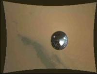
Heat shield impact in MARDI image! Haven't yet checked if it shows up in more than one. It's near bottom of image:

|
Edit: Should've mentioned, the image is a crop of the full-res original http://mars.jpl.nasa.gov/msl-raw-images/msss/00000/mrdi/0000MD9999000358E1_DXXX.jpg. For now, I don't think there are any more.
Posted by: pmetschan Aug 16 2012, 04:04 AM
Wow that would be great if it shows up in the final hires video!
Posted by: Astro0 Aug 16 2012, 04:09 AM
Very quick cropped gif of the "http://www.unmannedspaceflight.com/index.php?showtopic=7401&view=findpost&p=188744" zone.
Posted by: EdTruthan Aug 16 2012, 05:38 AM
Here's a quick and dirty video at just under full resolution of all frames so far till touchdown with a nice 0.5 sec crossfade added to give it some some fluidity. Keeping the bit rate up to at 8k to keep the crossfades crispy makes it a 35.3 MB file. Am thinking even when all frames are eventually down that finding just the right cross fade time at 4fps will definately sweeten up the smoothness. What a ride.
http://www.edtruthan.com/mars/mardi-so-far-2012-08-15.mpg
Posted by: elakdawalla Aug 16 2012, 05:53 AM
Here's an animated GIF of the first 16 full-res frames (the ones at 4 fps), aligned onto a crater feature on the floor. Very smooth! Attached is half-res; https://planetary.s3.amazonaws.com/emily/mardi_fulls_1.gif is full-res. I didn't notice until doing this the shadow of the backshell cast onto the heatshield during the first several frames.
|
Posted by: Nix Aug 16 2012, 06:53 AM
 very smooth indeed. That fullress complete movie is going to be amazing at least...
Posted by: Astro0 Aug 16 2012, 07:00 AM
The other thing I quite like from the full frames is the 'glare' / ccd bleed(?) coming from the bright areas on the HS, ie: the edges and large white section.
Almost the feel of speed streaks as it races through the atmosphere!
Posted by: Ondaweb Aug 16 2012, 01:33 PM
Thanks for pointing that out Astro, it does make it look like the HS is speeding away.
Posted by: Oersted Aug 16 2012, 01:42 PM
Who needs James Cameron when we've got Mike Malin... :-)
Posted by: elakdawalla Aug 16 2012, 03:58 PM
You know, I thought it was frame transfer smear, but if you look at the frames, the "bleed" isn't vertical; its angle varies. I think it's glare? Hopefully mcaplinger can tell us.
Posted by: ugordan Aug 16 2012, 04:08 PM
Did you rotate any of the frames or just align them in that gif?
Posted by: mcaplinger Aug 16 2012, 04:09 PM
Why ask me when you've got Mike Malin?

google for "interline smear":
http://www.truesenseimaging.com/support/reference-documents/doc_download/1-interline-image-sensor-smear
The smear moves since the image is moving as the CCD is being read out.
Posted by: jmknapp Aug 16 2012, 05:53 PM
93 consecutive MARDI images just came down, the time interval being right around touchdown--I put them together real quick (no processing) and put the sequence on youtube:
http://www.youtube.com/watch?v=MiYtPOD68lo
Whoosh!
The frame rate of the video is 5 fps. That's the MARDI frame rate, no?
The youtube uploader said: "We have detected that your video is shaky and has poor lighting--would you like us to fix that?"
NO!
Posted by: djellison Aug 16 2012, 05:58 PM
It's more like 3.88
These are all quite a way before touchdown - they show the divert maneuver and the beginning of the constant velocity phase.
Posted by: brellis Aug 16 2012, 06:00 PM
Holy WOW! Thanks Knapp
Posted by: jmknapp Aug 16 2012, 06:09 PM
These are all quite a way before touchdown - they show the divert maneuver and the beginning of the constant velocity phase.
The timestamp on the last frame is 5:17:36--what's 21 more seconds of terror?
Posted by: brellis Aug 16 2012, 07:20 PM
My hands were clenched, even though whatever happened had already happened several minutes ago, lol
Posted by: JebbPA Aug 16 2012, 07:48 PM
Very nice Mardi images! Does anyone know at what altitude the ground is starting to get stirred up? kind of hard to tell without any scale..
Thanks
Jonas
Posted by: pmetschan Aug 16 2012, 08:17 PM
I would love to know as well especially as it relates to my post (#127) Could you guys offer some feedback on whether or not that placement looks accurate?
Posted by: JTN Aug 16 2012, 08:20 PM
Cool -- so if one were particularly keen, one could partially reconstruct the relative motion of the heatshield (through the frame) between frames?
Posted by: djellison Aug 16 2012, 10:32 PM
The dust getting picked up is probably from the throttle up for the deceleration to 0.75m/sec - so we're probably around 55m up.
Posted by: mcaplinger Aug 16 2012, 11:54 PM
In theory I guess there's some information there, though it would require an understanding of how smear is formed (and since the scene is moving pretty slowly in this sequence, there's probably not much if anything that normal interpolation/tracking between frames couldn't tell you.)
Posted by: ToSeek Aug 17 2012, 02:03 AM
http://www.edtruthan.com/mars/mardi-so-far-2012-08-15.mpg
Sounds like a cool idea, but I couldn't get the video to work on either my Windows PC at work or on my Mac at home.
ADMIN: ALL, please note this before posting. Codecs? Software? Presumably you've tried all solutions before just posting that you couldn't watch it.
Posted by: Ian R Aug 17 2012, 02:49 AM
Plays fine in VLC
Posted by: Explorer1 Aug 17 2012, 03:46 AM
Right click on the link and save as, Toseek. Play it in whatever your OS says (though I recommend VLC too).
Posted by: Brian Lynch Aug 17 2012, 10:27 AM
Yes, you can see it in frame 359 and 360 which are now available. Matches the 'family portrait' of the landing site nicely (although my overlay job is a bit crude):

Posted by: iMPREPREX Aug 17 2012, 11:44 AM
Hey guys. I love this site. I wish I knew about it earlier!!!
Anyways, with what I have, I pulled off a 25 second HD version of MARDI recording the landing.
It's on Youtube. I hope I can post this. I don't recall it in the rules, but I am known to miss things... :/
Enjoy and I can't wait to see this when ALL of the frames are there. There are only about 220 in this one.
Please watch in 1080 at full screen and enjoy. I can't stop watching it. The heat shield! The thrusters!!! That last 2 seconds of just the rocks...
I'm very excited!!
http://www.youtube.com/watch?v=2lT06NbhN-A
Posted by: ToSeek Aug 17 2012, 01:48 PM
Okay, I was trying to run it straight out of the browser both at work and at home. I'll try it with VLC on my Mac tonight.
Posted by: climber Aug 17 2012, 06:33 PM
Paolo
200m to the East? Bingo Paolo, you've got some work to do. It's where John Grotzinger just said we'll be heading to!

Posted by: jmknapp Aug 17 2012, 06:42 PM
Yet another youtube video of the MARDI frames so far, gaps and all. I applied some quick and dirty brightness/contrast/sharpness filtering--maybe a little garish, but hey, these things are superseded with each new batch of MARDI frames anyway:
http://youtu.be/wDSuVICTVIU
(topical soundtrack added)
Posted by: nprev Aug 17 2012, 07:02 PM
...damn. Just awesome, Jim.
Question: We seem to be getting better & better details of the plume blasts on the surface. Is this of any potential value for future EDL system design?
What I'm getting at specifically is whether the blast patterns as seen provide any indications of unexpected thruster behavior. Clearly, it worked exceedingly well but it would be most interesting if these images show something unusual in their performance.
Posted by: jmknapp Aug 17 2012, 07:25 PM
...damn. Just awesome, Jim.With a handle jmknapp, I get my share "Jim's" but note the small sig below.
I kind of like it though, like Dr. McCoy in a lighter moment, "...damn, just awesome, Jim."
I agree the descent stage looked perfect, like a couple of mammoth leaf blowers. Man, that's a dusty place.
Posted by: nprev Aug 17 2012, 07:45 PM
...I actually spent a minute trying to remember if it was Jim or Joe, missed your signature. Sorry, Joe; still awesome!
Posted by: ElkGroveDan Aug 17 2012, 09:17 PM
I agree Ned. Joe's work is awesome.
Posted by: nprev Aug 17 2012, 09:57 PM
...yeah, I earned that!
Posted by: atomoid Aug 17 2012, 10:27 PM
once on the ground, the scene alternately dims and brightens a few times as if were seeing dramatic effects from a shadow cast by the skycrane exhaust plume cloud passing over!! ..or sadly just mere mundane camera exposure effects??
Posted by: elakdawalla Aug 17 2012, 11:14 PM
It wouldn't be the skycrane plume, it would be the massive cloud of dust that you can see the engines kicking up as it lands, turbulently billowing away.
Posted by: Big Joe Aug 17 2012, 11:29 PM
JPLnews jut posted video of heat shield impact.
http://www.youtube.com/watch?v=vVLPXfF3l_U
Posted by: iMPREPREX Aug 18 2012, 12:13 AM
Hey guys. I love the work I see here!
I posted this in the wrong thread before. It's my take on 220 or so of the high resolution images of MARDI.
I was able to get it uploaded at 1080p, so the detail is amazing! Can't wait for the rest of the frames! This is uncompressed, of course.
And I don't know any better so I download each image one at a time.  But it's worth it!
Enjoy! Please watch in full screen and 1080. The bigger the screen, the better.
http://www.youtube.com/watch?v=2lT06NbhN-A
Not trying to step on anyone's toes. Just posting my take.
Posted by: Ant103 Aug 18 2012, 12:21 AM
Thisi is AMAZING IMPREX Thanks for posting and sharing ! This is very good
With some sounds, it will be perfect.
Posted by: atomoid Aug 18 2012, 12:55 AM
http://www.youtube.com/watch?v=vVLPXfF3l_U
now i puruse http://curiositymsl.com/?page=2&orderby=ettaken&sort=ASC&limit=20&thumbsize=large&cams=mardi or view the http://www.youtube.com/watch?v=2lT06NbhN-A to try to figure out exactly which MARDI images show the impact but thats tougher than expected since jpl fixed the orientation and cropped it.. anyone know?
Posted by: elakdawalla Aug 18 2012, 02:02 AM
Frames 336-360. Most are not on the raws page yet (I just checked).
Posted by: iMPREPREX Aug 18 2012, 02:31 AM
Thanks for posting and sharing ! This is very good With some sounds, it will be perfect.
Thanks!
Maybe I will when I get the last of them. I do work with and record audio so it would be no problem as I have all the software.
That's a good idea, the more I think about it! How does sound travel on Mars? I don't know much about physics. I wonder what it really sounded like...
Posted by: atomoid Aug 18 2012, 02:56 AM
thanks! in the raw images we do have it shows up best in the bottom of the last few frames http://mars.jpl.nasa.gov/msl-raw-images/msss/00000/mrdi/0000MD9999000358E1_DXXX.jpg just before it disappears out of view.
Posted by: bdshort Aug 18 2012, 03:47 AM
That's really great work so far with what we have of the high res images. I'm looking forward to someone mixing in the audio from the EDL team with the HD frames once they've all come down. Now, I don't suppose anyone here has Adobe After Effects? It has a feature that will basically interpolate new frames between existing frames. One of it's uses is for creating smooth slow motion video from normal speed 24 or 30 fps video, if I understand it correctly. I think it would be a great tool to apply to these images to create some VERY smooth, real time video of the landing, but it's specialized video production software. Maybe there is something cheap or free that does the same thing. I'll have to look.
Posted by: um3k Aug 18 2012, 03:50 AM
@bdshort:
Take a look at Avisynth combined with the MVTools 2 plugin. With the right settings it gives results comparable to and sometimes better than After Effects.
Posted by: elakdawalla Aug 18 2012, 04:02 AM
There's an explainer on AVISynth on my blog here: http://www.planetary.org/blogs/emily-lakdawalla/2011/3157.html (thanks to Ian Regan, who explained it all to me).
Posted by: Pando Aug 18 2012, 05:16 AM
Funny... I messed around with AVISynth, MVTools2, and VirtualDub for several hours last night and this morning trying to interpolate the frames for the heat shield separation sequence... The motion frames (at least the first few) are far too much apart so it couldn't figure out the proper motion no matter what I tried, but perhaps more professional tools and expertise can pull that off.
Some areas in the landing sequence can be made pretty smooth, but the problem there is lack of contrast. The motion vectors get confused and there are some artifacts and funny ground movements.
Anyway, they are great tools, but lots of time is needed tinkering with the settings and scripts to get acceptable results.
Posted by: jmknapp Aug 18 2012, 08:09 PM
I should mention on my video anyway I held the last frame for 4 seconds or so, so the plume effects might have persisted longer than is apparent from the video.
That last frame, 1318 (which is still the last full frame released), is still 186 frames (48 seconds) away from the end of the ultimate video (last frame is 1504), so we should see quite a bit more if anything continues to swirl around.
Over 100 more frames were released today but there are ultimately 1,504 and the current total is still only 418.
Posted by: djellison Aug 18 2012, 10:27 PM
I had a stab at doing an MSSS like re-projection and rotation. Net result of all 600ish frames online so far -
http://youtu.be/v45vFbTg6KM
I'm playing them at 6fps ( so 150% of realtime )
Posted by: ups Aug 18 2012, 10:29 PM
(topical soundtrack added)
Very nice especially with the soundtrack.
Posted by: mcaplinger Aug 19 2012, 12:00 AM
Very nice. Barring some kind of frame in-betweening I don't know if it'll get a lot better than this. I wasn't expecting the actual touchdown to be so dark (the exposure time had to be constant all the way through). Aesthetically I think I might leave the lens distortion in because the curvy edges are distracting -- we're all used to looking at GoPro video lots more distorted than this
Maybe having two versions makes sense.Posted by: jmknapp Aug 19 2012, 12:27 AM
Hmmmm... wonder why they haven't all been released to the public site (just 418 as of now).
Posted by: nprev Aug 19 2012, 12:37 AM
Are they even all down yet? Remember that there was a four-day pause for the v10 software load.
Posted by: jmknapp Aug 19 2012, 12:42 AM
I meant all of the aforementioned 600ish.
Posted by: iMPREPREX Aug 19 2012, 01:05 AM
http://youtu.be/v45vFbTg6KM
I'm playing them at 6fps ( so 150% of realtime )
You, sir, beat me to it.
Awesome job! I love the MARDI landing videos! No matter who makes it!Here's my take at 10 FPS. I can't imagine what it's going to be like with all 1200 frames...
http://www.youtube.com/watch?v=nnspXCF16tA
And I need to learn how to batch download. "Right click, Save image as, click back button, repeat". Argh!
Edit - added/switched video in post. Now we're at 669 frames.
Keep it coming! And to the bottom poster - Ahhaha - right? This beats any Hollywood movie. I can't wait to see the dust settle!
Posted by: Decepticon Aug 19 2012, 02:27 AM
MY GAD!
I get enough of these descent movies.
I don't need hollywood anymore! I got NASA/JPL!
Posted by: JRA Aug 19 2012, 07:37 AM
Wow, these MARDI video's just keep getting better and better. Great work to everyone who has put one up.
Posted by: James Sorenson Aug 19 2012, 08:59 AM
Has anyone noticed in the full frame MARDI images, during the last second's untill touch down, all the small pebbley rocks that are seen flying everywhere in the FOV? They are enshrouded in the dust that was kicked up, but you can make them out. Wow!
Posted by: iMPREPREX Aug 19 2012, 10:07 AM
I saw that and loved it. And to think - the first 600 or so frames that we have so far are of the first half. Right when the blaster and dust kick up is where we have sparse frames. There is a whole extra minute starting right there. So, if I'm not mistaken, the video should be over two minutes long...
I can't wait to see that part.
Posted by: Lightning Aug 19 2012, 12:38 PM
http://youtu.be/v45vFbTg6KM
I'm playing them at 6fps ( so 150% of realtime )
And there is still this "yellow disk" effect that impact roughly half of the image. This quantification effect appears on full sized jpg, but I hope the real "raw" tiff images don't have this artifact. Will these uncompressed images be downloaded to Earth and be available ?
Posted by: ugordan Aug 19 2012, 02:52 PM
Inspecting the images in the Lab colorspace, it seems to me this color banding is indeed due to heavy compression of the chrominance data. Whether these raws have been recompressed on the ground again (which would be kind of pointless...) or if it happened onboard, I do not know.
I believe the raw images can sit in MARDI memory for as long as needed (unless that space is eventually needed for other applications of the camera), however returning uncompressed data would take about 2 megabytes per frame, more than 10x the current largest (raw page) file size.
If the banding is really caused by the camera compression settings, I wonder if the JPEG parameters onboard could (someday) be tweaked to recompress the raw images again, but only return less compressed chrominance data and not waste any bits on luminance that time around.
Posted by: jmknapp Aug 19 2012, 02:52 PM
Here's a small graphic showing the coverage so far in the MARDI frames on the public site:
|
|
Ultimately, the last frame, based on the thumbnails, will have sequence number 1504. Doug said upthread that the frame rate is about 3.88, so that would translate to about 6:45, but everything past frame 600 or so is post-touchdown.
Posted by: mcaplinger Aug 19 2012, 03:05 PM
CAHVOR model in ftp://naif.jpl.nasa.gov/pub/naif/MSL/kernels/ik/msl_mardi_20120731_c02.ti
http://www.msss.com/science/msl-mardi-pre-launch-images.php have some straight lines that could be used for rough geometric removal.
Posted by: Pando Aug 19 2012, 05:50 PM
I don't know if this has been discussed before, but I am wondering if MARDI camera can still be used during the science mission? Considering that it kept taking images after landing for a while, can it be commanded to take more images as the rover drives, or was it just programmed to take images during landing and that's it? Possible uses could be to characterize the soil under the rover, slip detection during drive, etc.
Posted by: DavidVicari Aug 19 2012, 05:54 PM
Yes, they plan on using it again during the mission.
Posted by: mcaplinger Aug 19 2012, 05:55 PM
Read the last paragraph of http://www.planetary.org/blogs/emily-lakdawalla/2012/msl-mardi.html
Posted by: Pando Aug 19 2012, 05:58 PM
Fantastic, thanks Mike!
Posted by: PDP8E Aug 20 2012, 01:54 AM
I have been working with the fabulous MARDI images and I have a question for the MSSS people that post here...
I have noticed in a lot the thumbnails, that there is a region in the South-East quadrant that has funny horizontal lines
The full images that correspond to the thumbnails also have interesting JPG artifacts in the SE quad
Here is a representative thumbnail with the funny region blocked off with a white line.
It is MARDI '525', the one just before we see dust interaction from the descent stage rockets.
Here are the corners of the corresponding 525 full frame image. I have cropped out each corner in the image @3x
(NW, NE, SE, SW, to show what I mean)

|
Is this a MARDI processing effect?
Are there non-lossy images in the pipeline for the future?
Note: As is, these are historic images - this is just a 'in the weeds' technical question.
Posted by: Astro0 Aug 20 2012, 01:57 AM
We've been discussing those questions for most of this thread 
Posted by: PDP8E Aug 20 2012, 02:15 AM
Astro-zero, is that the aforementioned 'interline smear' effect? ???
Posted by: stevesliva Aug 20 2012, 02:21 AM
Astro naught.
Posted by: mcaplinger Aug 20 2012, 03:32 AM
Are there non-lossy images in the pipeline for the future?
It's an interline smear effect. I've posted about that a few times now. There are ways to remove it cosmetically from the JPEG images.
I don't know if we'll end up sending back all of the frames lossless. It would take quite a while to do so, especially in competition with other science data. And the smear artifacts would still be there to some degree.
If we only ever have these JPEGs, I'd be about 95% satisfied personally. I started working on descent imaging in 1995 for MPL and it's been a long road. (The MPL MARDI would have gotten about a dozen grayscale frames.)
Posted by: nprev Aug 20 2012, 03:38 AM
On that note, belated major congratulations, Mike.
I know you've waited a long, long time for this, and it's been an incredible triumph!
Posted by: iMPREPREX Aug 20 2012, 08:38 AM
Hey folks. 200 more frames just popped up.
My take, once again:
http://www.youtube.com/watch?v=bjYJftADVAM
I really wish I would interpolate the frames - or is that called "tweening" or something? I don't know...
Posted by: jmknapp Aug 20 2012, 10:20 AM
Where are you seeing these? I can't see them at http://mars.jpl.nasa.gov/msl/multimedia/raw/?s=0&camera=MARDI
Even with interpolation, maybe the video would still be pretty shaky due to the "wrist mode" effects.
Posted by: climber Aug 20 2012, 11:03 AM
Thanks for pointing out heatshield hitting the surface, nearly impossible if you don't know when and where to watch for it in the video
Edited: I mean "thanks for having pointed out"
Posted by: MahFL Aug 20 2012, 11:05 AM
It's a real life EDL, it's going to be a bit bumpy......
Posted by: Explorer1 Aug 20 2012, 04:30 PM
Note that you can see the shadows on the surface moving slightly at the very end. This just gets better and better....
Posted by: iMPREPREX Aug 20 2012, 05:22 PM
Even with interpolation, maybe the video would still be pretty shaky due to the "wrist mode" effects.
Ok. It's a real pain in the butt to do all in all, but it works...
Click on a full resolution image from the MARDI section. Now, the last 200 frames I got are roughly in the 1200's or so.
So now you're viewing an image in full resolution.
Once there, go to the URL and merely change the number of the image. You have to keep trying and fill in the gaps (it's a real pain like I said).
Let me know if that works for you.
Oh - and I saw someone do frame interpolation. It looked AWESOME! But there were many artifacts. Still awesome. Almost looked like real time. I don't remember where the heck I saw it, though!
Best I can say is search YouTube. It's worth it.
Edit - you got it, Climber.
Posted by: jmknapp Aug 20 2012, 05:47 PM
Holy cow, you're right. I did what you said with a little more automation, i.e., took the list of thumbnails (frames 1-1504), changed "I1" to "E1" on all of them and then tried a wget on the list. turns out there are 936 full frame MARDI images on the site, even though the thumbnail page only links to 418 of them right now. Pretty much all the frames up through landing are there. Here's a current list of image urls if anyone wants to wget them:
http://curiositymsl.com/mardiframes.txt
So if an image is on the web site, but there's no link to it, has it really been released?
The interpolation might not be too hard, since most frames are pretty close to a simple translation, rotation and scaling from the previous.
Posted by: ugordan Aug 20 2012, 06:32 PM
Heatshield sep and especially dust kicked up will exhibit severe artifacts, however.
Posted by: iMPREPREX Aug 20 2012, 06:42 PM
http://curiositymsl.com/mardiframes.txt
So if an image is on the web site, but there's no link to it, has it really been released?
The interpolation might not be too hard, since most frames are pretty close to a simple translation, rotation and scaling from the previous.
Right? Isn't that strange?
My guess? If it's on the server, then it's there. Maybe not "published" to the site itself, but it's there. But I do wonder why they aren't on the page themselves. Any ideas, anyone? (no conspiracies, of course
)You now have 100 more frames then me. Congrats. Go make a great video now!
And what automation if you don't mind me asking? A script? If that's the case, then it's out of my reach.
Oh, you said wget. Must check out.
Posted by: stevesliva Aug 20 2012, 07:00 PM
There is a "URL Flipper" firefox add-on that does this sort of thing.
https://addons.mozilla.org/en-US/firefox/addon/url-flipper/
Posted by: iMPREPREX Aug 20 2012, 07:05 PM
https://addons.mozilla.org/en-US/firefox/addon/url-flipper/
You guys are all awesome. Thank you so much.
Isn't it cool that we can do this ourselves? I never knew this until a week ago. I thought NASA ALWAYS did their image processing - with no one else involved. Heck - I didn't even know the images are public domain. But I'm young, so...
But this is like, the coolest hobby I have ever had.
Posted by: jmknapp Aug 20 2012, 08:07 PM
Website glitches I'd guess. The last time they listed new MARDI images was on Saturday & a lot of the thumbnails came up broken & they're still broken last I checked. It is weird that CHEMCAM and MASTCAM etc. images have come in since without problem though.
OK, check this out:
http://youtu.be/yM9Dlk9NMc8?hd=1
I put JPL mission control audio in the background. It's hard to say how it should be lined up. I made it so that the announcement of the skycrane maneuver more or less lined up. There seem to be a few discrepancies (like the timing of the divert maneuver). But anyway, close enough for youtube.
Oh, you said wget. Must check out.Yep, script on a Linux box & not even the more common bash variety. I use 'ksh' because that's what I know.
Posted by: djellison Aug 20 2012, 08:18 PM
You did the same thing I did
http://youtu.be/RZioPhfxnSY?hd=1
Posted by: jmknapp Aug 20 2012, 08:26 PM
http://youtu.be/RZioPhfxnSY?hd=1
I like the Neil Armstrong-esque moment at the end when Allen Chen says "Now we'll see where Curiosity will take us."
Posted by: Oersted Aug 20 2012, 11:23 PM
For me the killer phrase is "Tango Delta nominal", after having it explained by Steltzner. Pilots should use that one more!
Posted by: MahFL Aug 21 2012, 12:26 AM
And what about the gasp the person makes after TD is declared, you could just sense the relief of years of tension, and some small disbelief it all worked, awesome.
Posted by: djellison Aug 21 2012, 12:28 AM
Yeah - but that was only the vehicle telling us it had issues the command to the descent stage to flyaway.
0.6 seconds after that command - the descent stage throttles up to 60% of 4 engines for 6 seconds. In those 0.6 seconds, the bridles and umbilical have to cut...oh...and the descent stage now has no idea what its altitude is - it just assumes it's level and 'ok' for those 0.6 seconds before throttling up. That was the scary bit
Hence the pause and the wait for confirmation that several second had elapsed after that time that included a continued strong UHF signal, and the RIMU ( rover IMU ) was stable. THEN - @icancallubetty could call 'Touchdown Confirmed'
Posted by: iMPREPREX Aug 21 2012, 08:14 AM
http://youtu.be/RZioPhfxnSY?hd=1
I even did it, and then I came here and saw that you guys did it. Are we psychic?
Great minds think alike...Mine is probably less accurate because I only took the most important snippets of audio, while probably leaving a few out because I couldn't fit it - being that I run it at 10 frames per second. I guess I like the smoothness, and I can't interpolate...
Here's mine. This is getting exciting!
http://www.youtube.com/watch?v=jILyoPoyakU
Enjoy! I enjoyed yours too, guys, and I dig that you guys do it in real time (4 fps). That's the true way. Mine is more of a composite, if you will.

Posted by: walfy Aug 21 2012, 08:48 AM
Thanks for all those links to great MARDI movies! Here's a version I just had to try, with the heat shield centered in each frame, makes for a slightly less queasy ride, though you lose the benefit of full frame. After shield disappears it gets a little sloppy until the images settle on the impact site. I couldn't figure out how to approximate the path of the heat shield from where it disappears to where it sends Martian dust flying. Not only is the camera wobbling around, it's descending, so I found it nearly impossible to make a smooth glide between the points, and pressed for time, just had to get sloppy. Are these the highest resolution images we'll ever see of the MARDI series? (Sorry if that was already answered).
I'm hoping some wizards here can do something similar by superimposing the MARDI images onto a background HiRISE image! With the background HiRISE colorized to match the MARDI shots. To my limited knowledge of such skills, it seems to me that would take an awfully long time and would require specialized software.
I should mention that after the first 10 frames it zooms in to 100% pixel representation from original that is, it's a direct crop from the original.
http://www.youtube.com/watch?v=MlQGMbulf1o
Posted by: iMPREPREX Aug 21 2012, 10:52 AM
That version is unbelievable. I love the image stabilization.
Wow.
Is that interpolated????
Posted by: MichaelJWP Aug 21 2012, 11:52 AM
Some very nice work here. I work in CG animation and post-production, but don't have the time to match some of these great efforts. Inter-frame interpolation would be hard I think in the early frames due to the big difference between frames. You could in theory do a painstaking job by hand, basically hand "rotoscoping" the heat shield to cut it out and repainting the background where needed - a lot of work though. Also image stabilisation will always be a compromise - how much of the original swaying beneath the canopy do you want to remove?
This is historic footage though, ranks up there with Apollo descents and the so far one-off descent to Titan by Huygens.
Posted by: charleski Aug 21 2012, 11:54 AM
...
http://www.youtube.com/watch?v=MlQGMbulf1o
That video is superb! Great work.
Posted by: Oersted Aug 21 2012, 01:24 PM
Walfy, great idea and execution! - Really helpful to know the heatshield is always in the exact center of the frame: I could follow it much longer than in any of the previous vids.
Now I'm thinking it would be great with another vid where the landing site remains in the center, to visualize the various gyrations and "detours" on the way down to the eventual target.
Another idea for a visualization: to leave - in the movie - the swathes of terrain already imaged by MARDI, and then "additively" superimpose the images as the stage descends. The viewpoint should of course follow the descent stage on the way down, but a bit above it, to take in the surrounding scenery "painted" by the earlier MARDI shots... Don't know if I am explaining myself well, but I think it would look great...
Lots of ways the imagery can be visualized, only the imagination sets a limit. I'm thrilled with what has been shown so far and look forward to much more!
Posted by: elakdawalla Aug 21 2012, 04:09 PM
I find the number of different ways you guys are interpreting the MARDI data to be wonderfully surprising. I did not anticipate such variety!
Posted by: fredk Aug 21 2012, 04:45 PM
Another idea would be to animate the full frames uncropped, but to highlight the precise landing spot in each frame somehow. Maybe with a subtle cross. I find it tough to follow the exact landing site.
Another would be to centre each frame on the landing spot (I guess that'd get hard when the landing site is not in view). That could be done by cropping, like walfy's insanely cool version centred on the heatshield. Or it could be done by not cropping, but instead increasing the full movie frame size to whatever is needed to fit in all of the offcentre frames. That would probably mean you'd need a huge resolution movie, two or three times HD! The result would be like keeping your gaze fixed at the landing spot, but with a full-resolution view window that slowly reels around.
Posted by: Brian Lynch Aug 21 2012, 08:22 PM
http://www.youtube.com/watch?v=MlQGMbulf1o
That is really cool, well done!
I've taken the ephemeris file from JPL HORIZONS, combined it with some of the estimated altitude and velocity values at critical events, and interpolated the data to produce the EDL trajectory. Here is a video of the results, with the terrain elevation included from MGS MOLA.
http://youtu.be/SY0TokNKlfI
*Be sure to view the video at 720p. I know the text is difficult to read and I will adjust this for the next iteration (combined with MARDI images and mission control audio).
I will also post the results in Excel or delimited text format once I've arranged the data appropriately and uploaded it to the web.
Posted by: Oersted Aug 21 2012, 10:49 PM
Love it Brian, especially the way the ground track dips and climbs over elevation features. Very pro!
Posted by: Astro0 Aug 21 2012, 11:44 PM
This is awesome.
Eyes on the Solar System's EDL sim in sync with the MARDI footage and then just to make it glorious, a commentary from Adam Steltzner.
http://www.youtube.com/watch?feature=player_profilepage&v=GMsdobLq1-4
Posted by: iMPREPREX Aug 22 2012, 02:57 AM
Oh man, that was too cool. I mean - I can't believe how accurate "Eyes on the Solar System" was. And the syncronization to the film was just out of this world (arg - pun).
That was my favorite one yet, but they're all great.
Posted by: walfy Aug 22 2012, 04:20 AM
Wow.
Is that interpolated????
It wasn't interpolated, but the frame rate was set at about 10 fps. I basically started by pulling all the full-res images into a Photoshop file as layers. That took a lot of memory, over 2 GB. With layers stacked in order, I then lined up the heat shield in the center using cross-hair guide, for each image layer, until the shield merged into background Mars surface. Also pulled out the highlights in each image, to the same extent for all of them, made them brighter, less dull. Then I saved a jpg copy of each repositioned layer, numbered each file the same as the MARDI sequence (4 were actually missing!), put them all in a folder. Then used QuickTime on my Mac which has an awesome feature that imports a series of images to make a quick movie out of it, letting you choose frame rate. The files must be numbered in sequence. Then brought the QT movie into iMovie, then upload to YouTube.
Some other nice movies today, lots of fun to watch. Brian's is very cool, mind-blowing how everything suddenly plummets when slowed down enough, dropping right on the target area. Very fine science going on that predicted the entry and descent path.
Posted by: CosmicRocker Aug 22 2012, 04:45 AM
Nice work, everyone. Really nice work.
Posted by: walfy Aug 22 2012, 06:21 AM
Wow.
Is that interpolated????
I forgot to mention: if anyone else sets out to make their own version with the heat shield centered in each frame, or to use a part of the surface of Mars as the center, be forewarned that there is a flawed pixel that will hop around. The pixel isn't noticeable much when the series is viewed full-framed, since the pixel is in the same position each frame. But when you track the heat shield, that pixel will jump around, sometimes in circular patterns, as it matches the wobbling of the descent stage. It was very distracting at times, having the effect of something flying around the heat shield as it fell. I Photoshopped it out on many, many frames! Thought it worthwhile as well to keep the intrigue-prone at bay. Here it is next to the heat shield in frame 72:

Posted by: climber Aug 22 2012, 07:04 AM
Specialy when you think at the only 3 pictures from Spirit!
Neither I was prepared for such variety. We'll end up with many different products may be more than the EDL team was thinking of. I do hope they enjoy watching what our wizards are posting here
Posted by: chuckclark Aug 22 2012, 10:57 AM
Just speculating here, but could the errant pixel be exploited as an indicator of wobble?
Posted by: chris Aug 22 2012, 01:10 PM
There's a new (to me) video here http://www.nasa.gov/multimedia/videogallery/index.html?media_id=150865751 that I found via the MSSS website. It shows the MARDI video alongside an Eyes on the Solar System view of EDL. I imagine this will get properly synched once all the EDL data is downloaded.
Chris
Note: Mentioned just a few http://www.unmannedspaceflight.com/index.php?showtopic=7416&view=findpost&p=189390
Given the pace that this thread is developing it's always good value in reading back several pages.
Whoops my bad.
Posted by: pac56 Aug 23 2012, 03:24 PM
Another beautiful MARDI sequence in HD:
http://cosmiclog.nbcnews.com/_news/2012/08/22/13419779-watch-the-rover-fall-to-mars-in-hd
Posted by: elakdawalla Aug 23 2012, 08:00 PM
Another ~150 frames just hit the raws page. There are a few that look grayscale/checkerboarded, which must mean we're looking at photos that have not been de-Bayered, right?
http://mars.jpl.nasa.gov/msl-raw-images/msss/00000/mrdi/0000MD9999000354C0_DXXX.jpgThis is one of the frames of the heat shield impact -- maybe they're bringing that down uncompressed?
There's a couple more non-de-Bayered ones from later in the sequence, I'm assuming for landing site context.
Posted by: ugordan Aug 23 2012, 08:07 PM
Sure looks that way, and yes, that implies lossless transmission (neglecting 12->8 bit conversion). If only these were available in PNG just so we can try our own de-Bayer...
EDIT: Here's a de-Bayer attempt on that image. The jpeg compression on the ground introduced the "matrix" noise which shouldn't be visible with uncompressed data.

|
Posted by: elakdawalla Aug 23 2012, 08:14 PM
Can't have everything, Gordan! Phoenix and New Horizons both provided PNG images on their raws pages at U. Arizona and APL, but that just doesn't seem to be JPL's style. Which makes me wonder what the data release timeline is. I couldn't find the answer with a variety of searches. Anybody know?
Posted by: mcaplinger Aug 23 2012, 08:28 PM
Yes, these were sent losslessly compressed, and then apparently JPEGed for release, which is kinda gross IMHO. Because of compression artifacts I wouldn't bother trying to do much with these, though maybe you guys will surprise me.
Posted by: mcaplinger Aug 23 2012, 08:30 PM
I'm not so sure, this looks like residual smear artifact to me. Maybe the JPEGed "raw" frames are not so different from the original images after all.
Posted by: mcaplinger Aug 23 2012, 08:35 PM
Six months, assuming that the usual MEP PDS policy applies. http://pds-geosciences.wustl.edu/missions/mep/mepdmp.pdf
Posted by: ugordan Aug 23 2012, 08:44 PM
I don't know, JPEG does have trouble with high frequency stuff like Bayer patterns, it could be just neighboring pixel values coupled to one another. If you look real closely in the JPEGged image some of the DCT blocks have distinctly different-looking patterns than the others, which you wouldn't expect given most of the terrain is of very similar color.
Posted by: Lightning Aug 23 2012, 10:52 PM
Posted by: mcaplinger Aug 23 2012, 11:08 PM
PDS requires you to archive, in decompressed raster form, whatever you got from the spacecraft. It was discussed upthread whether all of the raw frames will ever be returned from EDL; if they are, then they'll end up in PDS, and if they're not, they won't. I believe the six-month clock starts running when the last image that will be in a particular archive delivery is received.
Posted by: Big Joe Aug 24 2012, 06:18 AM
I wanted to try and bring out some detail in the descent images and I really like this as a black and white. Thank you MSSS!
You can just make out the rim of Gale crater.
http://www.flickr.com/photos/fxmurphy/7849146928/
Posted by: Pando Aug 24 2012, 06:58 AM
I think I got all the MARDI images now from heatshield separation to landing.
Here is a Youtube video at 5 fps, 25 fps with frame interpolation (starting at ~7 seconds into the video).
View it with 1080p, and you can easily follow the heatshield almost all the way down until impact! Wheeee!
http://www.youtube.com/watch?v=waEiMKdNgGU
Posted by: nprev Aug 24 2012, 07:26 AM
There must be something wrong with me. I just can't get enough of this!!!
Beautiful work, Pando; thank you very much!!!
One question/observation: In this version, it's really striking how the DS seems to just lock right into a straight vertical descent during the terminal phase after the offset maneuvers & some oscillation. Ignorant as I am of imagery techniques, is this an accurate impression of the behavior of the vehicle at that time?
If so, it is most impressive, and any near-surface winds seem to have had virtually no impact on the last few meters before landing despite the slow descent rate. Don't know if that means that there was little or no wind, or if that's due to some really spectacular precision control; would love to know the answer.
Posted by: Brian Lynch Aug 24 2012, 07:29 AM
I've made a half decent attempt at correcting the MARDI images for lens distortion and projected the images onto a satellite map of Gale crater.
Here is a video of the results for the first 89 frames (32 to 120):
http://youtu.be/z5mU7FYWZ6k
From the projections I will be able to estimate the vehicle's attitude, so stay tuned!
Posted by: Pando Aug 24 2012, 07:38 AM
One question/observation: In this version, it's really striking how the DS seems to just lock right into a straight vertical descent during the terminal phase after the offset maneuvers & some oscillation. Ignorant as I am of imagery techniques, is this an accurate impression of the behavior of the vehicle at that time?
Thanks nprev! I think you're seeing the skycrane descent, where the vehicle is being lowered with 3 bridles from the skycrane, which has the vertical stabilization inherent to the system. The interpolated video really makes this apparent.
Posted by: Brian Lynch Aug 24 2012, 07:47 AM
If so, it is most impressive, and any near-surface winds seem to have had virtually no impact on the last few meters before landing despite the slow descent rate. Don't know if that means that there was little or no wind, or if that's due to some really spectacular precision control; would love to know the answer.
Agreed, and as someone with research interests in automated control for this kind of thing, I was also really surprised at just how accurately the descent stage stabilized the orientation, position, and velocity of the spacecraft. Like you said, I guess there were very few perturbations from wind, etc., but still amazingly solid, my hat goes off to the people that engineered the control algorithms for descent and attitude control using the rocket motors!
Posted by: jmknapp Aug 24 2012, 10:27 AM
Here is a Youtube video at 5 fps, 25 fps with frame interpolation (starting at ~7 seconds into the video).
View it with 1080p, and you can easily follow the heatshield almost all the way down until impact! Wheeee!
http://www.youtube.com/watch?v=waEiMKdNgGU
That is really sweet. Taking out the stuttering effect of the low frame rate really brings out the "wrist mode" dynamics.
Posted by: Brian Lynch Aug 24 2012, 11:32 AM
Here is a preview of MSL's orientation during descent, as derived from MARDI images projected onto a satellite image of Gale crater:
http://youtu.be/8mSHcfYlFII
The process seems to give a fairly good estimate, so after projecting all of the images I will post the complete version. I'll also try to get around to putting together a description of the algorithm I used since it is quite simple once you have a quadrilateral describing the projected image bounds.
To see a plot of the results: https://dl.dropbox.com/u/97443049/msl_mardi_attitude4.png
Posted by: elakdawalla Aug 24 2012, 04:56 PM
I recall that at one of the press briefings, they said MSL was more stable during terminal part of descent for the simple reason that it's so danged heavy.
Posted by: djellison Aug 24 2012, 05:04 PM
That's an amazing piece of work Brian - nicely done!
Posted by: Lightning Aug 24 2012, 05:18 PM
http://youtu.be/8mSHcfYlFII
The process seems to give a fairly good estimate, so after projecting all of the images I will post the complete version. I'll also try to get around to putting together a description of the algorithm I used since it is quite simple once you have a quadrilateral describing the projected image bounds.
Posted by: djellison Aug 24 2012, 05:21 PM
GOod point lightning - but one could back out to a location and orientation by using the corners of the images and triangulating back.
Posted by: Lightning Aug 24 2012, 05:47 PM
Yes of course, a lot a linear and non-linear solutions can resolve that, but I was just asking that question because the arrows didn't move in the video.
By the way, good job Brian, espacially if you've done each image by hand.
Posted by: Brian Lynch Aug 24 2012, 06:09 PM
Actually, you don't need the position relative to the ground. The projected images are transformed from the original rectangular shape (after lens correction it is still a rectangle but with black, or transparent, parts around the corrected image) into quadrilaterals. Then you consider the field of view of the camera as a rectangular pyramid whose edges represent the corners of the image. The quadrilaterals will then be the intersection of a rotated plane with the pyramid (kind of like conic sections resulting in circles, ellipses, parabolas, etc.) so the orientation of the ground with respect to the camera can be found by identifying the rotation of that plane.

Here you can see the projected image's quadrilateral shape in red, and the camera field of view pyramid in purple, with the blue box representing the rectangular viewing region from the camera's perspective (ie. the actual output image we see). By using the known field of view angle for MARDI (70° in width) you can then compute the relative height of each corner of the quadrilateral. Then it is simple geometry to determine the rotation of the plane formed by those vertices. That rotation gives you the roll and pitch of the ground with respect to the camera. Since the corners are also rotated with respect to the ground frame of reference (ie. the satellite image which is oriented north), you can get the yaw angle from the overall rotation of the pyramid.
So, you never need the actual position of MSL with respect to the ground since that doesn't have an impact on the shape of the quadrilateral (of course this is assuming terrain effects are negligible... ie. an idealized flat ground).
Posted by: Airbag Aug 24 2012, 06:25 PM
Yet a different way of looking at the MARDI data - I extracted the "average brightest" (peak value for 2x2 bins) pixel value from all the frames following "wheels down" and plotted that versus the frame number to give an idea of how much airborne dust was obscuring the view. After frame 300 not much changed so I did not show those frames here.
The assumptions are that the exposures were fixed (which seems reasonable, given what we see in the images) and that the frames are contiguous. The latter does not seem to be true yet, based both on the discontinuities seen around frame 170 and also in the file names themselves.
However, even with the presumed missing frames, the plot clearly shows the obscuration due to the flying dust, and that the dust settles and billows up a couple of times or so over time. Also shown is a small initial brightening due to the light colored dust being kicked up. [Edit: Arguably, it also shows the permanent obscuration of MARDI due to dust on the lens since the data is based on peak values, and there is no reason why the sunlit portion of the close up should not otherwise have the same peak values as the images from before the landing.]
Airbag

|
Posted by: fredk Aug 24 2012, 06:26 PM
I'm really curious how accurate this will be. I guess it's limited by how well you match the corners to the orbital map, and by how well you know the field of view.
Edit: Holy smokes, that's cool, Airbag!
Posted by: Brian Lynch Aug 24 2012, 06:48 PM
Yes, knowing the actual field of view of the camera and the scale of the original image, you can deduce the position of the camera as well. I've tried applying this to find the altitude and these are the results:

https://dl.dropbox.com/u/97443049/mardi_attitude_comp3.png
The blue line is the altitude derived from the images as we are discussing, the black line is the altitude as determined from interpolated ephemeris data (from JPL HORIZONS), and the red line is a linear fit to the blue line.
The noise is mainly due to the fact that the image projection is not perfect which you can see in the video showing only the images (http://youtu.be/z5mU7FYWZ6k). Also, the HORIZONS data is only a prediction of the trajectory and the actual entry and descent altitude profile is likely a bit different, including the fact that events such as heat shield separation may not have occurred at the same time as the prediction. However, the linear fit deduced altitude from MARDI images is at least fairly close to the predicted altitude, and has a similar trend. I will have to try updating the HORIZONS trajectory since they may have posted the true ephemeris.
By the way, good job Brian, espacially if you've done each image by hand.
Kind of, each image is loaded into the MATLAB image processing control point selection GUI, which allows you to select similar features in each image and automatically generate the transformation and projected image. Finding the features at first was difficult, but then each subsequent frame only needs a minor adjustment. Of course doing this for all 700 or so frames of the descent will take a little longer... my PhD thesis needs attention as well
Posted by: Brian Lynch Aug 24 2012, 07:16 PM
I'm really curious how accurate this will be. I guess it's limited by how well you match the corners to the orbital map, and by how well you know the field of view.
Edit: Holy smokes, that's cool, Airbag!
That is a good point, and after looking at the video and the altitude profile, you can see that the really noisy part of the altitude profile corresponds to the frames where the projection stretches out into the mound. Considering that Mt. Sharp is about 5.5 km tall, the surrounding mound would indeed have a big effect on this analysis (you can see the elevation of the mound in http://youtu.be/SY0TokNKlfI).
I'm not really sure how to account for the ground elevation, since the projection alignment uses only the images. Perhaps the quadrilateral can be modified afterwards so that the corners are shifted out of plane by the appropriate elevation. I do have a terrain model derived from MGS MOLA grayscale height maps of the region, so perhaps I'll give it a try.
Posted by: fredk Aug 24 2012, 07:35 PM
Accounting for the elevation should be straightforward. Identify the four corners on the orbital image. Use the DTM (or contour map or whatever) to find the heights of the four corners. Then solve for the position/attitude using the x,y,z coordinates of the four corners.
I suppose using a proper DTM would be best, since the x,y (lat,long) coords read from a particular orbital view may be off on the mound if the orbiter wasn't exactly overhead. (This is the same effect we're talking about correcting for in mardi.)
So ideally, identify the surface locations of the four corners. Then find the corresponding x,y,z coords from a DEM. Then feed those into the position/attitude algorithm.
Posted by: Lightning Aug 24 2012, 09:51 PM
Posted by: Brian Lynch Aug 24 2012, 10:04 PM
Yes, you are correct, I was only interested in finding the attitude at first, but if you know the locations of the corners (say in latitude and longitude) and the camera FOV then you can determine the position. I've looked at the altitude (http://www.unmannedspaceflight.com/index.php?s=&showtopic=7416&view=findpost&p=189749) but haven't attempted to extract the other components of the spacecraft position yet.
Given the poor estimate of the altitude I don't think the position estimate will be very good, but still interesting to give it a try. Perhaps if people are interested I will post a spreadsheet of the quadrilateral coordinates, however, I need to go back to the base picture and determine the reference point for latitude and longitude in order to change the quadrilateral coordinates as such. (Right now I simply work in units of pixels and then apply a rough pixel scaling factor determined from the base image to get the altitude, but for the orientation the units do not matter). Of course you could still work without a reference point and simply compute the relative position over the set of images.
I find when you watch the video there is a tendency to think the orientation is incorrect since the -Z axis doesn't point to the center of the image (the coordinate frame rotates to the correct orientation but doesn't move as you say). Estimating the position would allow you to move the coordinate frame so that the -Z axis does actually point from the camera location to the projected image.
Posted by: Lightning Aug 24 2012, 10:57 PM
JPL Trajectory reconstruction should arrive soon, it will be much more precise than what could be achieved from these images. In particular, your precision will be limited by human accuracy and precise localisation of the features.
But registration for the sake of beautiful registration is already a tough job, and you performed it very well.
Posted by: Brian Lynch Aug 24 2012, 11:28 PM
But registration for the sake of beautiful registration is already a tough job, and you performed it very well.
Thanks, I am pleased with the results and can't wait to get all of the images registered. I'm really looking forward to seeing the JPL reconstruction of the trajectory, and I hope they include as many of the parameters as possible.
Posted by: Brian Lynch Aug 25 2012, 06:50 AM
I've now determined the spacecraft orientation and position from the projection of MARDI images (ground elevation is still not considered) for frames 32 to 120. Take a look at the video, which shows the raw MARDI images after correcting for lens distortion, then the projected images, plots of the position and orientation profiles, and finally an interesting view along the camera axis which aligns fairly well.
http://youtu.be/cUFkA59L0Z8
Posted by: paraisosdelsistemasolar Aug 25 2012, 10:16 AM
Your videos are superb, I'd love the creative ways you are showing the descent videos. I've created some anaglyphs with MARDI frames, so I hope you enjoy them! (Comments and and advice are welcome!)
http://www.ungeologoenapuros.es/wp-content/uploads/2012/08/0000MD9999000213E1_DXXX.jpg
http://www.ungeologoenapuros.es/wp-content/uploads/2012/08/0000MD9999000381E1_DXXX.jpg
http://www.ungeologoenapuros.es/wp-content/uploads/2012/08/0000MD9999000466E1_DXXX.jpg
http://www.ungeologoenapuros.es/wp-content/uploads/2012/08/descent11.jpg
http://www.ungeologoenapuros.es/wp-content/uploads/2012/08/descent21.jpg
http://www.ungeologoenapuros.es/wp-content/uploads/2012/08/descent31.jpg
Posted by: Big Joe Aug 25 2012, 03:29 PM
Wonder if you can create true anaglyphs from these images but it's is worth a try maybe someone can answer that question? I like the idea paraisosdelsistemasolar.
Still learning about how to de-Bayer the MastCam images.
http://www.flickr.com/photos/fxmurphy/7857411040/
Posted by: paraisosdelsistemasolar Aug 25 2012, 04:18 PM
Of course you can create them! Take this new anaglyphs as new examples. Take a look on the shiny reflections on the heatshell:

|

|

|
Posted by: stewjack Aug 25 2012, 11:57 PM
The heatshield is close the camera and very high above the ground. That is fairly easy. Trying to get really great 3D of the dunes is hard! I was hoping to get extremely exaggerated vertical relief on those dunes, but I couldn't do it. I could barely show any relief!
I like this http://www.ungeologoenapuros.es/wp-content/uploads/2012/08/descent11.jpg of yours, because the dunes show some vertical relief, but it is obvious that they are on a flat horizonal plane with the lower slopes of Mount Sharp rising behind them in the upper or Southerly direction.
IMO: With MARDI the camera can rock back and forth and make it appear that the images are showing a wide separation of perspective, when in fact it is just like someone taking a picture ( with a wide field lens ) of an apple in the left of the image and then ( standing in the same place ) taking another picture with the apple on the right side! You don't get any 3d from those two graphic image files!
You don't say what software you are using. I could never get anaglyphs made from mastcams images to show anything realistic before using good software. I have only published one so far - see below:
http://www.unmannedspaceflight.com/index.php?act=findpost&hl=&pid=189878
http://www.unmannedspaceflight.com/index.php?act=attach&type=post&id=27692
Jack
Posted by: fredk Aug 26 2012, 02:00 AM
Best I could do with a MARDI anaglyph, using frames 52 and 53:

|
Definite stereo effect between heatshell and ground, but definitely no stereo on the ground. To see stereo on the ground, you'd need frames separated by a pretty long interval I think, and then you'd need substantial scaling/reprojecting.
Posted by: Brian Lynch Aug 26 2012, 04:21 AM
For all of you making stereographic images: is it possible to save the image as an actual stereoscopic image file, like .jps?
I have the NVIDIA 3D Vision package on my computer and would love to see your pictures using my shutter glasses. I've had some success with Sol 3 images when they came out, but I'd love to see what you've done with the MARDI images (and others). When I upload the files to the NVIDIA 3D Vision gallery they automatically generate anaglyph images, so if you want to see them check out:
http://photos.3dvisionlive.com/bklynch/
If you want to see the stereoscopic .jps files, go to:
http://lynchb.webs.com/msl/msl_stereo.html
(I applied a copper color map to make it feel like Mars instead of keeping the images grayscale... hope that isn't a faux pas considering the high quality and professionalism of this forum!)
Posted by: paraisosdelsistemasolar Aug 26 2012, 08:44 AM
Hi Stewjack!,
I'm using only Photoshop for the anaglyphs. Maybe it's easier to use some kind of software for that, but Photoshop let me have some kind of control over the image. If you need advice or something, don't heasistate to PM.
Greetings!
Posted by: paraisosdelsistemasolar Aug 26 2012, 09:26 AM
Two new anaglyphs trying to make some more relief in the dunes zone:

|

|
Posted by: elakdawalla Aug 26 2012, 03:40 PM
Use http://stereo.jpn.org/eng/stphmkr/ for conversion among a jillion 3D formats. (I feel like a broken record here; I've suggested Stereophotomaker five times in the last week.)
Posted by: stewjack Aug 27 2012, 12:04 AM
If you need advice or something, don't hesitate to PM.
I don't have any professional interest, but I did enjoyed creating wide-baseline flicker gifs when Spirit was climbing around the Husband Hills. I have just been acquainting myself with the new types of images that MSL provides. I should have no problem taking 2 Navcam images, ( taken 200 meters apart, in say a WSW direction,) of identical area's of Mt Sharp's lower slopes - and making an anaglyph from them! However, I have not yet mastered MastCam images.
Thanks for the offer of advise, but at the present time it appears I will be very busy in the near future. The is a large storm named Issac moving in my direction. Unless we get lucky, I may not be posting on this board for a week at least.
Packing for a possible trip
Jack
Posted by: Tom Tamlyn Aug 27 2012, 02:50 AM
From Gawker's affiliate io9.com, a http://io9.com/5938006/this-is-hands-down-the-most-breathtaking-version-of-curiositys-descent-weve-seen-yet praising a fully "tweened" 25 fps http://www.youtube.com/watch?v=fJgeoHBQpFQ, with a discussion of the methods used by the creator. As far as I can tell, this hasn't been posted here.
TTT
Posted by: Pando Aug 27 2012, 03:44 AM
Interesting! Thanks Tom for posting it. It's a nice effect, especially at the first 7 seconds when the heat shield is falling close-up. That is scary smooth. The rest of the video is a bit jumpy though as the timing from interpolated frames don't quite match up with the frame rate. Perhaps it's a side-effect from the 4fps to 25fps conversion, which is not an equal multiple. Given enough time, professional tools and skills can produce some amazing results.
I posted my version a few days ago, with full frames (not cropped), and done purely with an algorithm (not by hand) using only freeware tools. The first 7 seconds was impossible to do, as the script really screwed up the image, so I opted for simple fades instead. To do it properly requires some heavy manual rotoscoping (tools which I don't have). The rest is pretty smooth though, except for a few artifacts when the motion happened too quickly between the frames.
http://www.youtube.com/watch?v=waEiMKdNgGU
Posted by: bdshort Aug 27 2012, 05:18 AM
TTT
Thanks for sharing this. Pretty epic, and even if it's cropped, and you miss the heat shield impact, the widescreen and music definitely make it the most cinematic of the videos posted so far. It also doesn't appear a lot of detail was lost due to compression.
Posted by: Tom Tamlyn Aug 27 2012, 05:29 AM
Pando,
I didn't mean to deprecate your wonderful (full frame!) (1080p!) version, and I apologize for incorrectly suggesting that Dominic Muller's version was the first to use interpolation to create a 25 fps video.
I thought the most interesting and gratifying aspect of the article to which I linked is that it reflects continued widespread interest in Curiosity generally, as well as a growing interest in the kind of enthusiast's visual products for which umsf.com is known.
Gawker is a gossip site, and it isn't, for the most part, any better than it ought to be. (The exceptions are so off-topic that I risk suspension even thinking about them as I type this.) The existence of this breathless MARDI headline on Gawker is a tribute to the insight and persistence of Mike C. and his MSS colleagues in championing descent imagery so long and with such spectacular ultimate success. I don't see outreach and education on the http://www.msss.com/science/msl-mardi-science-objectives.php, but I suspect that these goals were in the minds of everyone involved in creating and approving the instrument, and appropriately so.
TTT
Posted by: Pando Aug 27 2012, 03:54 PM
Tom, I am terribly sorry if my earlier post may have appeared to give this impression, definitely wasn't my intention...
I'm really glad you posted the link, and I merely mentioned my own video for comparison purposes. Actually, there are quite a few really good youtube videos out there with all kinds of effects added (deshaked, stabilized, interpolated, heat-shield centered, etc), some posted way earlier than Dominic's or mine. His video is amazing, and there is a lot of work behind it.As you said, a huge credit goes to NASA/JPL/MSSS for releasing the data into public domain, which has generated great interest and excited the inner-geek in all of us. There are many talented people who are honing their skills working with the data in so many different ways. I'd also like to give special thanks to Doug and UMSF crew for their hard work in making it possible for us to be part of this mission.
Posted by: Pando Aug 29 2012, 08:04 PM
This youtube video is a winner, in my opinion. It's got the stabilized and stitched MARDI descent imagery, simulation, EDL checklist, and NASA TV feed all synchronized into the frame. A fantastic work all around.
http://www.youtube.com/watch?v=lZuzSxQ_Zeg
Posted by: dot.dk Aug 29 2012, 08:19 PM
Needs your interpolation
Posted by: Ondaweb Aug 29 2012, 08:52 PM
http://www.youtube.com/watch?v=lZuzSxQ_Zeg
Great presentation. Makes it touching again. And stirs appreciation/congratulations to the team again.
Posted by: Pando Aug 30 2012, 03:20 AM
Here's a heavily enhanced video running at 15 fps that starts immediately after landing. You can see some small rocks blowning around in the rocket exhaust. A more interesting event is at 6-7 seconds (corresponding roughly 25 seconds after landing). I have a hard time explaining the quick brightening and dimming of the image. Does anyone have any ideas here?
http://youtu.be/ChWuPt2cgnE
Posted by: maschnitz Aug 30 2012, 03:34 AM
For what it's worth - I always figured that was the dust clouds that the retros kicked up, blowing over the rover and/or in front of the Sun from that angle.
Posted by: mcaplinger Aug 30 2012, 03:37 AM
Nice video, the best I've seen yet of the post-landing data. I think the flashing is just variation in the dust cloud opacity (and possibly shadowing by the descent stage, not sure of the timing on that); it never seems to get any brighter in the sunlit strip than it is at the end. I've looked at all of the thumbnails and there is some flashing, perhaps not as much as your video shows.
Posted by: Pando Aug 30 2012, 03:40 AM
I looked over the frames again, and it seems that there are many missing frames right at the 6-7 second mark and after, so the quick dimming and brightening of the image is mostly artificial.
Powered by Invision Power Board (http://www.invisionboard.com)
© Invision Power Services (http://www.invisionpower.com)