Opportunity Route Map |

  |
Opportunity Route Map |
 Feb 4 2010, 11:36 PM Feb 4 2010, 11:36 PM
Post
#2671
|
|
 Member  Group: Members Posts: 404 Joined: 5-January 10 Member No.: 5161 |
QUOTE (Tesheiner @ Feb 4 2010, 01:28 AM)  Huh?  Sorry, but I don't see the coincidence. And no, I'm just a "space enthusiast", no "insider". You're right, they are a little different. I didn't compare them closely... |
 |
 
|
|
Feb 5 2010, 09:11 AM
Post
#2672
|
|
|
Senior Member Group: Moderator Posts: 4279 Joined: 19-April 05 From: .br at .es Member No.: 253 |
|
|
|
|
|
Feb 5 2010, 08:00 PM
Post
#2673
|
|
 Senior Member Group: Members Posts: 4246 Joined: 17-January 05 Member No.: 152 |
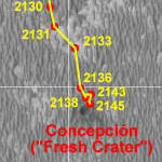
Tesheiner, I wonder if it might be useful for some (those not actively using GE?) to provide a larger-scale closeup map showing our route as we circumnavigate Concepcion?
|
|
|
|
|
Feb 6 2010, 01:18 AM
Post
#2674
|
|
|
Solar System Cartographer Group: Members Posts: 10150 Joined: 5-April 05 From: Canada Member No.: 227 |
Maybe I'll post a close-up after this stop is over. I made them for some of our other stops.
Phil -------------------- ... because the Solar System ain't gonna map itself.
Also to be found posting similar content on https://mastodon.social/@PhilStooke NOTE: everything created by me which I post on UMSF is considered to be in the public domain (NOT CC, public domain) |
|
|
|
|
Feb 7 2010, 10:12 AM
Post
#2675
|
||
|
Senior Member Group: Moderator Posts: 4279 Joined: 19-April 05 From: .br at .es Member No.: 253 |
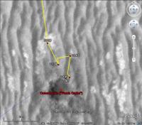
Map update after sol 2147. The rover's position change is barely visible on the 1m/pix map so here's a snapshot taken from the GE version.
 Route_Map_Sol2147.kml ( 40.21K )
Number of downloads: 501
Route_Map_Sol2147.kml ( 40.21K )
Number of downloads: 501 |
|
|
|
|
|
|
Feb 12 2010, 12:31 AM
Post
#2676
|
|
 Administrator Group: Admin Posts: 5172 Joined: 4-August 05 From: Pasadena, CA, USA, Earth Member No.: 454 |
For those of you who want to follow Eduardo's latest maps in GE since Oppy wandered off the included HiRISE base map, I've mirrored the HiRISE image map update here (256 MB Zip file; download, unzip, and then open "MER-B map extension version 2.0.kml" within Google Mars).
-------------------- My website - My Patreon - @elakdawalla on Twitter - Please support unmannedspaceflight.com by donating here.
|
|
|
|
|
Feb 12 2010, 08:37 PM
Post
#2677
|
|
|
Senior Member Group: Moderator Posts: 4279 Joined: 19-April 05 From: .br at .es Member No.: 253 |
Great, Emily!
Perhaps I should include a link to it on the route map... |
|
|
|
|
Feb 13 2010, 02:14 AM
Post
#2678
|
|
|
Member Group: Members Posts: 813 Joined: 29-December 05 From: NE Oh, USA Member No.: 627 |
Folks...
I am in GOOGLE MARS doing the a slow roll along Tesheiner's route mapping for Oppy and listening to "Winds of Mars" CD. Highly recommend the experience WOW... what a relaxer ........ Craig |
|
|
|
|
Feb 13 2010, 07:54 AM
Post
#2679
|
|
 The Poet Dude Group: Moderator Posts: 5551 Joined: 15-March 04 From: Kendal, Cumbria, UK Member No.: 60 |
That's really useful, thanks Emily!

-------------------- |
|
|
|
|
Feb 13 2010, 09:28 AM
Post
#2680
|
|
 Member Group: Members Posts: 754 Joined: 9-February 07 Member No.: 1700 |
thx Emily! It's like living a dream to fly around G.Mars
|
|
|
|
|
Feb 18 2010, 07:16 PM
Post
#2681
|
|||
|
Member Group: Senior Member Posts: 136 Joined: 8-August 06 Member No.: 1022 |
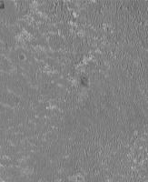
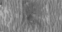
QUOTE (brellis @ Feb 13 2010, 01:28 AM) thx Emily! It's like living a dream to fly around G.Mars Hi all! I've been trying to find a streamlined way of posting my Opportunity location maps for public access for some time now, and hopefully that's going to start happening soon (today?). In the meantime, here are my latest (remember that Oppy hasn't moved in a few sols). First is the map at the HiRISE mosaic resolution of 25cm/pixel. Second is a 5cm/pixel projection of the Navcam panoramas onto the HiRISE image, around Concepcion.
Attached thumbnail(s)
|
||
|
|
|
||
|
Feb 18 2010, 08:25 PM
Post
#2682
|
|
 Senior Member Group: Members Posts: 1083 Joined: 19-February 05 From: Close to Meudon Observatory in France Member No.: 172 |
your data is perfect as usual, Tim !
|
|
|
|
|
Feb 18 2010, 09:08 PM
Post
#2683
|
|
|
Senior Member Group: Moderator Posts: 4279 Joined: 19-April 05 From: .br at .es Member No.: 253 |
QUOTE (tim53 @ Feb 18 2010, 08:16 PM) I've been trying to find a streamlined way of posting my Opportunity location maps for public access for some time now, and hopefully that's going to start happening soon (today?). KML files for Google Mars on the MER website maybe? That would be great! QUOTE (tim53 @ Feb 18 2010, 08:16 PM) Second is a 5cm/pixel projection of the Navcam panoramas onto the HiRISE image, around Concepcion. I presume that's a projection of the 3D meshes generated from both L&R images. I would love to put my hands on such tools... |
|
|
|
|
Feb 18 2010, 09:10 PM
Post
#2684
|
|
|
Member Group: Senior Member Posts: 136 Joined: 8-August 06 Member No.: 1022 |
QUOTE (Tesheiner @ Feb 18 2010, 12:53 PM) KML files for Google Mars on the MER website maybe? That would be great! I'm hoping to do that at some point soon, but need to get the paper writ first that includes contributions from JPLers to the planning software used to make the maps. -Tim. |
|
|
|
|
Feb 18 2010, 09:12 PM
Post
#2685
|
|
|
Member Group: Senior Member Posts: 136 Joined: 8-August 06 Member No.: 1022 |
QUOTE (Tesheiner @ Feb 18 2010, 01:08 PM) I presume that's a projection of the 3D meshes generated from both L&R images. I would love to put my hands on such tools... Forgot to comment on this. Yes, that is from the project's planning software. But I believe there is commercial software out there to do something similar, provided the camera models can be generated. For example, I use Point Grey Research firewire cameras for planetary imaging (I'm an amateur astronomer), and Pt Grey has stereo camera systems and software to build 3-D files from stereo pairs. There must be others, but I haven't had any opportunities (sorry for the pun) to explore these myself. -Tim. |
|
|
|
|

|
Lo-Fi Version | Time is now: 24th April 2024 - 03:15 PM |
|
RULES AND GUIDELINES Please read the Forum Rules and Guidelines before posting. IMAGE COPYRIGHT |
OPINIONS AND MODERATION Opinions expressed on UnmannedSpaceflight.com are those of the individual posters and do not necessarily reflect the opinions of UnmannedSpaceflight.com or The Planetary Society. The all-volunteer UnmannedSpaceflight.com moderation team is wholly independent of The Planetary Society. The Planetary Society has no influence over decisions made by the UnmannedSpaceflight.com moderators. |
SUPPORT THE FORUM Unmannedspaceflight.com is funded by the Planetary Society. Please consider supporting our work and many other projects by donating to the Society or becoming a member. |
|