A Global DEM of Rhea: Almost Complete, My most recent 'monster project' |

 Unmanned Spaceflight.com > Outer Solar System > Saturn > Cassini Huygens > Cassini's ongoing mission and raw images
A Global DEM of Rhea: Almost Complete, My most recent 'monster project' |
 Mar 31 2009, 12:39 AM Mar 31 2009, 12:39 AM
Post
#1
|
|||
 IMG to PNG GOD  Group: Moderator Posts: 2250 Joined: 19-February 04 From: Near fire and ice Member No.: 38 |
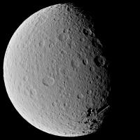
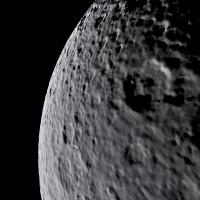
I'm now getting very close to finishing a near-global DEM of Rhea using stereo images. This has been a true 'monster project' involving 71 image pairs, a significant amount of software improvements and some impatience
 . .This has been an extremely interesting project but the results are fairly interesting. I have 'discovered' a highly degraded impact basin similar in size to Tirawa - it's not obvious in the source images. There are some interesting features near Tirawa's antipode that I think are real but I'm not completely convinced - if real they may or may not be associated with Tirawa's formation. I will post more details plus some crater depth measurements once I finish the DEM sometime in April. There are a few frustrating gaps in the DEM, the biggest one in the north polar region for obvious reasons and another one near longitude 0. The latter may get filled following a nontargeted flyby in June 2010 (assuming Rhea gets imaged the way I want ).I will probably be posting a flyover movie before mid-April and possibly a rotation movie as well. Meanwhile I'm posting two test renders:
The first one is from 3100 km from Rhea's center and has a FOV of 30°. The other one is from an altitude of 340 km and has a 45° FOV. I didn't drape a texture map over the DEM. The DEM is global so this wouldn't look realistic. The first one looks fairly realistic even though it is very obvious that it is computer generated. The second one reveals that the resolution of the DEM is several times lower than the resolution of the source images - they typically have a resolution of ~1 km/pixel. And as previously noted: There's more to come in the not too distant future. And an interesting decision: Which satellite to do next. |
||
 |
 
|
||
 Bjorn Jonsson A Global DEM of Rhea: Almost Complete Mar 31 2009, 12:39 AM
 Hungry4info Wow. For a second, I didn't realise that the f... Mar 31 2009, 01:05 AM ElkGroveDan Bjorn, I am speechless. Warn me before you post t... Mar 31 2009, 01:29 AM Bjorn Jonsson Just for fun here is a test image that represents ... Apr 7 2009, 11:56 PM
 tedstryk That is amazing! I do have to say that it lo... Apr 8 2009, 09:58 AM Phil Stooke Fantastic work on the DEM!
However, the sec... Apr 8 2009, 11:28 AM Bjorn Jonsson Thanks - I had forgotten the second basin was seen... Apr 8 2009, 09:51 PM DrShank Nice job!
ive done a similar map on my own, a... Apr 8 2009, 10:08 PM Bjorn Jonsson I have now made some improvements to the DEM and c... Apr 25 2009, 12:27 AM CAP-Team Great work!
Is it possible to create a normal ... Apr 25 2009, 12:53 PM ugordan Impressive work as always, Bjorn!
Interesting... Apr 25 2009, 04:23 PM stevesliva I was thinking the limb looked pretty sweet, too. Apr 25 2009, 06:04 PM Bjorn Jonsson I'm using a Hapke function with preliminary va... Apr 25 2009, 06:28 PM Bjorn Jonsson Thanks to DrShank's great map I realized that ... May 3 2009, 10:42 PM scalbers Very nice DEM and animation Bjorn. I suppose if on... May 3 2009, 10:54 PM Bjorn Jonsson Yet another animation, this time with a color/albe... Jun 4 2009, 11:06 PM Floyd Wow!!! that is really impressive. Jun 4 2009, 11:14 PM nprev ..."Stunning" doesn't even BEGIN to ... Jun 4 2009, 11:23 PM Poolio Wow! I am stunned. Speechless. I'll pro... Jun 4 2009, 11:39 PM CAP-Team Any chance you're going to release these maps ... Jun 8 2009, 06:12 PM brellis This is wonderful work! Amazing how the shado... Jun 9 2009, 02:30 AM
tedstryk That is amazing! I do have to say that it lo... Apr 8 2009, 09:58 AM Phil Stooke Fantastic work on the DEM!
However, the sec... Apr 8 2009, 11:28 AM Bjorn Jonsson Thanks - I had forgotten the second basin was seen... Apr 8 2009, 09:51 PM DrShank Nice job!
ive done a similar map on my own, a... Apr 8 2009, 10:08 PM Bjorn Jonsson I have now made some improvements to the DEM and c... Apr 25 2009, 12:27 AM CAP-Team Great work!
Is it possible to create a normal ... Apr 25 2009, 12:53 PM ugordan Impressive work as always, Bjorn!
Interesting... Apr 25 2009, 04:23 PM stevesliva I was thinking the limb looked pretty sweet, too. Apr 25 2009, 06:04 PM Bjorn Jonsson I'm using a Hapke function with preliminary va... Apr 25 2009, 06:28 PM Bjorn Jonsson Thanks to DrShank's great map I realized that ... May 3 2009, 10:42 PM scalbers Very nice DEM and animation Bjorn. I suppose if on... May 3 2009, 10:54 PM Bjorn Jonsson Yet another animation, this time with a color/albe... Jun 4 2009, 11:06 PM Floyd Wow!!! that is really impressive. Jun 4 2009, 11:14 PM nprev ..."Stunning" doesn't even BEGIN to ... Jun 4 2009, 11:23 PM Poolio Wow! I am stunned. Speechless. I'll pro... Jun 4 2009, 11:39 PM CAP-Team Any chance you're going to release these maps ... Jun 8 2009, 06:12 PM brellis This is wonderful work! Amazing how the shado... Jun 9 2009, 02:30 AM  |

|
Lo-Fi Version | Time is now: 30th April 2024 - 01:48 PM |
|
RULES AND GUIDELINES Please read the Forum Rules and Guidelines before posting. IMAGE COPYRIGHT |
OPINIONS AND MODERATION Opinions expressed on UnmannedSpaceflight.com are those of the individual posters and do not necessarily reflect the opinions of UnmannedSpaceflight.com or The Planetary Society. The all-volunteer UnmannedSpaceflight.com moderation team is wholly independent of The Planetary Society. The Planetary Society has no influence over decisions made by the UnmannedSpaceflight.com moderators. |
SUPPORT THE FORUM Unmannedspaceflight.com is funded by the Planetary Society. Please consider supporting our work and many other projects by donating to the Society or becoming a member. |
|