Feedback sought on Triptik-style maps for Curiosity traverse |

Feedback sought on Triptik-style maps for Curiosity traverse |
 Aug 3 2014, 03:30 AM Aug 3 2014, 03:30 AM
Post
#1
|
|||
 Administrator  Group: Admin Posts: 5172 Joined: 4-August 05 From: Pasadena, CA, USA, Earth Member No.: 454 |
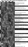
I'm working on the maps that I'll be including in my book and am looking for some feedback. My goal with these maps is to include as much information at a glance as possible. Another goal was to make something substantially different from what's in Phil's book
 And I have to work within the limitations of the Springer-Praxis page, which dictates maximum image sizes of 117mm wide by 198mm tall. The text that accompanies it will not go into every bit of sol-by-sol detail (you'll need to buy Phil's book if that's what you want) -- I'm taking a slightly more "zoomed-out" view of the operational proceedings in the text. Here is a first draft of one of my maps: And I have to work within the limitations of the Springer-Praxis page, which dictates maximum image sizes of 117mm wide by 198mm tall. The text that accompanies it will not go into every bit of sol-by-sol detail (you'll need to buy Phil's book if that's what you want) -- I'm taking a slightly more "zoomed-out" view of the operational proceedings in the text. Here is a first draft of one of my maps:
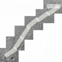
It may take a moment to orient yourself. North is not up. The inspiration for this style of map is the American Automobile Association Triptik that my family used to take with us for long road trips. Triptiks are books for a road trip made out of long skinny maps, each one of which takes you from one city to another along a major highway. Here's an example of what a typical Triptik page looks like. The maps are not oriented north-south -- instead, they were oriented to be parallel to the route of the highway. I decided to try the same thing here, orienting the map parallel to Curiosity's route, with time increasing from top to bottom of the page, which allows me to accompany each narrow strip of map with a timeline of sorts. The black-and-white bars running down the left side are 50 meters long, while the ones running along the top are 20 meters long. The grid is a 100-meter grid. One thing that differs between my approach and the AAA Triptik is that I plan to hold the map scale constant throughout. (It's 1:3000.) Here's a zoomed-out view showing how I'm dividing the first part of the Curiosity traverse into linear segments. (This map is the one I use for my planning -- it's not laid out appropriately for the book.)
The base map is an image taken after Curiosity passed through, so I didn't need to draw in the route at all -- I just highlighted the rover's tracks. I located the site dots based on Phil's maps. Each site is marked with the sols that Curiosity acquired data in that location. To the right of the map is an abbreviated list of the targeted science done at each site. It includes ChemCam targets (which always have Mastcam context images), plus any standalone Mastcam targets, and notes about other activities. I don't include astronomical observations -- I'm maintaining a separate list of those. Information on targets is compiled from midnightmarsbrowser.com and the SOWG reports from the Analyst's Notebook. One goal with this is to have the PDF be searchable on target names. Between the sites there are black bars for each drive. All the drive information is copied from curiositylog.com. In one location there was some mid-drive imaging, so I included that in the drive bar. I'm not sure if that was the best way to do that. Some of the sites have special symbols -- a triangle where they did contact science, and the wheel symbol is intended to indicate 360° panoramas. Any other suggestions for what ought to be indicated on the map? I would LOVE to be able to show the locations of DAN active measurements, but I don't know how to figure out where they occurred. I'm thinking about ways to indicate the location and heading of partial panoramas. It's frustrating that the Mastcam team often doesn't name their panoramas very succinctly -- there are a lot of panoramas described with words like "possible contact on distant hill". Finally, I should mention that this is a first draft, and I have *not* double-checked my work on the facts on this map. It very likely contains errors. Caveat emptor! I hope this map makes some sense to people! Feedback welcome. -------------------- My website - My Patreon - @elakdawalla on Twitter - Please support unmannedspaceflight.com by donating here.
|
||
 |
 
|
||
 elakdawalla Feedback sought on Triptik-style maps for Curiosity traverse Aug 3 2014, 03:30 AM
 Astro0 Nice Emily.
A few thoughts and questions.
On Sol... Aug 3 2014, 04:34 AM PaulH51 Emily, Did you consider including the relative ele... Aug 3 2014, 06:33 AM ngunn When using a conventional map most people would or... Aug 3 2014, 07:50 AM
Astro0 Nice Emily.
A few thoughts and questions.
On Sol... Aug 3 2014, 04:34 AM PaulH51 Emily, Did you consider including the relative ele... Aug 3 2014, 06:33 AM ngunn When using a conventional map most people would or... Aug 3 2014, 07:50 AM
 chuckclark QUOTE (ngunn @ Aug 3 2014, 02:50 AM) When... Aug 3 2014, 11:43 AM Gerald An overview of the DAN measurements can be found i... Aug 3 2014, 09:24 AM craigmcg One way to indicate the direction of a partial pan... Aug 3 2014, 11:48 AM Phil Stooke Really nice! I wish I had had this to refer t... Aug 3 2014, 03:31 PM Floyd Had the primary drive direction been anything Nort... Aug 3 2014, 03:49 PM Gerald QUOTE (elakdawalla @ Aug 3 2014, 05:30 AM... Aug 3 2014, 04:57 PM fredk QUOTE (elakdawalla @ Aug 3 2014, 04:30 AM... Aug 3 2014, 06:46 PM jmknapp Nice metaphor with AAA. One cosmetic point: I find... Aug 3 2014, 08:04 PM elakdawalla Everybody, thanks for your suggestions, lots of go... Aug 3 2014, 08:57 PM Gerald QUOTE (elakdawalla @ Aug 3 2014, 10:57 PM... Aug 3 2014, 11:18 PM chuckclark jmknapp's gray scale bars and gray Header bars... Aug 3 2014, 09:45 PM andrewc Regarding contour lines and elevation data: I sugg... Aug 4 2014, 05:54 AM Floyd Emily
"I find the consistency of the sugges... Aug 4 2014, 04:00 PM chuckclark QUOTE (Floyd @ Aug 4 2014, 11:00 AM) Map-... Aug 4 2014, 05:27 PM geckzilla I thought about this for a while tonight. What bot... Aug 5 2014, 05:55 AM serpens This is a valuable project and I look forward to r... Aug 6 2014, 12:03 AM chuckclark I have to say, for all I argued earlier for flippi... Aug 6 2014, 02:06 PM
chuckclark QUOTE (ngunn @ Aug 3 2014, 02:50 AM) When... Aug 3 2014, 11:43 AM Gerald An overview of the DAN measurements can be found i... Aug 3 2014, 09:24 AM craigmcg One way to indicate the direction of a partial pan... Aug 3 2014, 11:48 AM Phil Stooke Really nice! I wish I had had this to refer t... Aug 3 2014, 03:31 PM Floyd Had the primary drive direction been anything Nort... Aug 3 2014, 03:49 PM Gerald QUOTE (elakdawalla @ Aug 3 2014, 05:30 AM... Aug 3 2014, 04:57 PM fredk QUOTE (elakdawalla @ Aug 3 2014, 04:30 AM... Aug 3 2014, 06:46 PM jmknapp Nice metaphor with AAA. One cosmetic point: I find... Aug 3 2014, 08:04 PM elakdawalla Everybody, thanks for your suggestions, lots of go... Aug 3 2014, 08:57 PM Gerald QUOTE (elakdawalla @ Aug 3 2014, 10:57 PM... Aug 3 2014, 11:18 PM chuckclark jmknapp's gray scale bars and gray Header bars... Aug 3 2014, 09:45 PM andrewc Regarding contour lines and elevation data: I sugg... Aug 4 2014, 05:54 AM Floyd Emily
"I find the consistency of the sugges... Aug 4 2014, 04:00 PM chuckclark QUOTE (Floyd @ Aug 4 2014, 11:00 AM) Map-... Aug 4 2014, 05:27 PM geckzilla I thought about this for a while tonight. What bot... Aug 5 2014, 05:55 AM serpens This is a valuable project and I look forward to r... Aug 6 2014, 12:03 AM chuckclark I have to say, for all I argued earlier for flippi... Aug 6 2014, 02:06 PM  |

|
Lo-Fi Version | Time is now: 21st May 2024 - 01:38 AM |
|
RULES AND GUIDELINES Please read the Forum Rules and Guidelines before posting. IMAGE COPYRIGHT |
OPINIONS AND MODERATION Opinions expressed on UnmannedSpaceflight.com are those of the individual posters and do not necessarily reflect the opinions of UnmannedSpaceflight.com or The Planetary Society. The all-volunteer UnmannedSpaceflight.com moderation team is wholly independent of The Planetary Society. The Planetary Society has no influence over decisions made by the UnmannedSpaceflight.com moderators. |
SUPPORT THE FORUM Unmannedspaceflight.com is funded by the Planetary Society. Please consider supporting our work and many other projects by donating to the Society or becoming a member. |
|