Printable Version of Topic
Click here to view this topic in its original format
Unmanned Spaceflight.com _ Opportunity _ Cape York DEM
Posted by: algorimancer Jul 15 2011, 09:32 PM
pgrindrod was kind enough to share his DEM of western Endeavour with me (thank you  ); this is the same DEM he used to generate the visibility maps about Cape York. Following much effort spread over a couple of weeks (largest data set I've ever worked with), I was able to convert it to an STL file format and snip-out the vicinity of Cape York (once I found it) so that I could get a sense of scale. While there's a good drop-off to the east (nearly 30 meters), Cape York doesn't rise much above the plains approaching from the west.
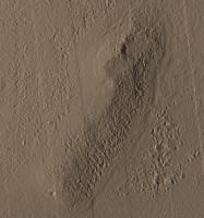
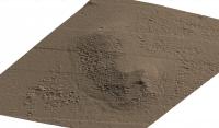
Here's an overview image, with north at top. I have illumination coming from the west at an angle of 30 degrees from horizontal. There is no vertical exaggeration.
|
The wedge/valley feature at the northeast corner is not very prominent here (perhaps it is more albedo feature than topological). As I recall, the resolution of the DEM is about .3 meters vertically on about a 1-meter grid. The dunes to the east show nicely, as does the crater that Oppy's headed towards at the south.
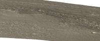
Here's a profile view from the west. The target crater is hidden by a small rise to the right.
|
|
Here's a profile view from the south. The target crater is to the left, and you can get a sense of topography and how the ground descends rapidly to the east (right). There is no vertical exaggeration in any of these views.
|
|
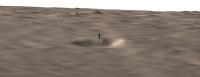
Here's a close-up view of the target crater from the south with a 2 meter figure standing near the north rim to provide scale. Cape York rises gently behind it.
|
Here's an oblique view from the north of Cape York -- you can just see the 2 meter figure as a blueish spike in the distance, though the crater it stands next to is hidden.
|
Another oblique view from the southest, where the 2 meter figure is just visible by the crater to the lower right.
|
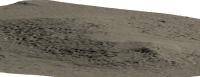
An oblique view from the northeast, nicely showing the dunes to the east (left) and all of Cape York.
|
And that's enough images for one post. Apologies for the color -- I tried a couple of variations. Enjoy. Credit goes to pgrindrod for the DEM and assistance in converting it to a format I could work with.
Posted by: Stu Jul 16 2011, 12:15 AM
Genuinely brilliant work, well done.
Looks like I may have been a tad over-optimistic with my peaks... 
Posted by: Phil Stooke Jul 16 2011, 12:18 AM
Don't worry, Stu, we can fix that.
Phil
Posted by: algorimancer Jul 17 2011, 01:33 PM
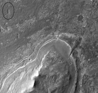
Glad you like it. For context, here's the beautiful color image that Stu posted last July as the first post in the "Geomorphology of Cape York" thread:
https://roadtoendeavour.wordpress.com/2010/07/06/cape-york-in-colour/
Just at the moment I'm still in a mental toss-up as to whether the Wedge/gully feature is topographic or an albedo feature. It could be a water-carved gully (unlikely as that seems), a fracture, or the debris field from an oblique impact from the south (which would make it largely an albedo feature). In the oblique view from the north there is that interesting linear depression extending away from Cape York towards the lower-right of the image -- this appears to be real, and not an artifact of the DEM-generating procedure.
Also in that image note the subtle layering evident off the northeast corner of Cape York, towards the bottom of the image. That looks like stratigraphy that Oppy might be very interested in.
Incidentally, not shown in these images is a ridge/ledge approximately due west of the north edge of Cape York, perhaps a few hundred meters off. This was obvious in the topography, but less so in the images, but I think that if Oppy is heading towards the south end it should not present a hazard. I'll see about posting an image of it tomorrow.
Posted by: fredk Jul 17 2011, 03:39 PM
I vote for topography. The lighting (from the west) in this view strongly suggests that it is a notch:
|
The step-like feature that extends most of the way around the circumference of CY (eroded layering?) appears to have a similar amount of relief as the notch from that orbital view, but is pretty subtle on your rendered perspective views. So I'd expect the notch to also be hard to see in the rendered views. Presumably that just means that the height of the step and depth of the notch are near the vertical resolution limit (30 cm).
As far as the notch's origin, we've seen many similar features on the plains (note circled feature in my view above), so I'd vote for a similar origin.
Posted by: Stu Jul 17 2011, 03:54 PM
While I don't believe in an Emerald City anymore, I do still have more than a little optimism that we're going to see a surprising amount of topography on and around CY. I guess we'll know soon.
BTW, for everyone's future reference, if you want to know how big a CY feature is compared to Oppy, she's roughly halfway in size between the two boulders ringed on this crop of my colour image...
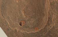
|
Posted by: algorimancer Jul 18 2011, 03:35 PM
Here's the topography spanning the north end of Cape York west to the "approach" crater, with the ridge/drop-off/dune that I mentioned earlier. If Oppy is visiting the crater prior to turning southeast, it doesn't look like this will present a problem. Still, the feature should be clearly visible to the south/southwest as Oppy passes the crater -- of course all eye will be to the east when that time comes .
|
Posted by: algorimancer Jul 18 2011, 07:25 PM
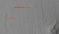
I did 4 height transects, 3 near the north of CY and 1 at the south passing through the middle of the target crater. Here's an image showing the transect locations, with an overlaid graph of the heights at each transects overlaid -- the graph is proportional, but not quite to scale. Units are in meters.
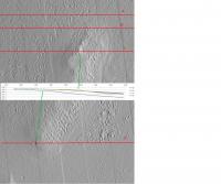
|
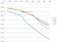
And here's a stretched graph of the transects; the target crater shows nicely at the bottom.
|
The layering seems evident in the transects. Transect C seems to be suggesting that the peak/ridge is more of a plateau/shelf.
Posted by: MoreInput Jul 18 2011, 08:53 PM
It's just about 10% slope down to the bottom, so put on the brakes now.
Posted by: algorimancer Jul 20 2011, 05:19 PM
The target crater may be a bit underwhelming.
|
|
Powered by Invision Power Board (http://www.invisionboard.com)
© Invision Power Services (http://www.invisionpower.com)