Marathon Valley, Sol 4078-4481 (July 15, 2015 - September 1, 2016) |

  |
Marathon Valley, Sol 4078-4481 (July 15, 2015 - September 1, 2016) |
 Jul 24 2016, 11:54 PM Jul 24 2016, 11:54 PM
Post
#301
|
|
 Senior Member  Group: Members Posts: 4246 Joined: 17-January 05 Member No.: 152 |
QUOTE (Floyd @ Jul 8 2016, 01:05 AM)  So are we off to stations 3-6? I don't know why Phil's map doesn't display--but follow link to Phil's post. Looks like my guess was wrong - we do seem to be checking out the area of those stations. We did abandon them abruptly when the approach of winter forced us to head to the north-facing slopes. |
 |
 
|
|
Jul 25 2016, 02:59 PM
Post
#302
|
|
 Member Group: Members Posts: 244 Joined: 2-March 15 Member No.: 7408 |
QUOTE (scalbers @ Jul 18 2016, 05:21 PM) Plus this from Herobrine: https://www.youtube.com/watch?v=e76uBfWxD74 As cool as that video is, I feel compelled to state that I had nothing to do with it and haven't seen it before now. It's possible scalbers meant to link https://www.youtube.com/watch?v=qHJemCKbhF4 or https://www.youtube.com/watch?v=jgjse9fGypA or https://www.youtube.com/watch?v=UyviCsjGsfg, which a friend and I created using PDS data and, in the last example, scalbers' sky scattering GIF. Note: The above videos have to be viewed in a YouTube viewer that supports VR, like the YouTube app on your smartphone probably does. They are unlikely to display properly on a desktop or laptop computer. |
|
|
|
|
Jul 26 2016, 02:40 PM
Post
#303
|
||
|
Senior Member Group: Members Posts: 2817 Joined: 22-April 05 From: Ridderkerk, Netherlands Member No.: 353 |
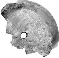
The Navcam L0 Panoramic view on Sol 4443 and Sol 4444.
Jan van Driel
|
|
|
|
|
|
|
Jul 28 2016, 08:09 PM
Post
#304
|
||
|
Solar System Cartographer Group: Members Posts: 10146 Joined: 5-April 05 From: Canada Member No.: 227 |
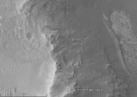
This is a circular reprojection of Jan's panorama (above).
Phil
-------------------- ... because the Solar System ain't gonna map itself.
Also to be found posting similar content on https://mastodon.social/@PhilStooke NOTE: everything created by me which I post on UMSF is considered to be in the public domain (NOT CC, public domain) |
|
|
|
|
|
|
Jul 28 2016, 09:34 PM
Post
#305
|
|
 Senior Member Group: Members Posts: 1624 Joined: 5-March 05 From: Boulder, CO Member No.: 184 |
QUOTE (Herobrine @ Jul 25 2016, 02:59 PM) As cool as that video is... Thanks Herobrine for helping to clear up my confusion about who is doing what with 3D / VR. Nice to see how the sky scattering looks combined with the terrain. -------------------- Steve [ my home page and planetary maps page ]
|
|
|
|
|
Jul 29 2016, 12:07 PM
Post
#306
|
|
 Member Group: Members Posts: 691 Joined: 21-December 07 From: Clatskanie, Oregon Member No.: 3988 |
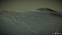
A screenshot preview of the current mosaic that Oppy is taking.
|
|
|
|
|
Aug 4 2016, 06:02 AM
Post
#307
|
|
|
Solar System Cartographer Group: Members Posts: 10146 Joined: 5-April 05 From: Canada Member No.: 227 |
I just updated the map to show the latest drive, sol 4453, which brings us almost to the rocks at Gibraltar II. If you are wondering where the recent names are from - Bashful II, Sleepy II and Gibraltar II, they commemorate the 40th anniversary of the first Viking landing on Mars by re-using rock names from the Viking sites. Sleepy and Bashful are at Viking 1, Gibraltar is at Viking 2.
Phil -------------------- ... because the Solar System ain't gonna map itself.
Also to be found posting similar content on https://mastodon.social/@PhilStooke NOTE: everything created by me which I post on UMSF is considered to be in the public domain (NOT CC, public domain) |
|
|
|
|
Aug 4 2016, 08:27 AM
Post
#308
|
|
|
Member Group: Members Posts: 691 Joined: 21-December 07 From: Clatskanie, Oregon Member No.: 3988 |
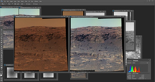
Any gorgeous view that Curiosity sees, Oppy can do better!
|
|
|
|
|
Aug 4 2016, 01:21 PM
Post
#309
|
|
|
Member Group: Members Posts: 910 Joined: 4-September 06 From: Boston Member No.: 1102 |
Looks like multiple nice long contact region between different formations or rock types. Have we explored similar contacts during the Winter Explorations on the North facing slope?
Which it looks like we are visiting on sol 4453.  -------------------- |
|
|
|
|
Aug 4 2016, 05:05 PM
Post
#310
|
|
|
Senior Member Group: Members Posts: 4246 Joined: 17-January 05 Member No.: 152 |
Wow, the latest PS update has a tremendous amount of detail about the plans for the next extension. First, we'll attempt to head through a break in Knudsen Ridge:
QUOTE Once Opportunity finishes shooting the panorama of the valleys northern wall, the mission will exit stage south, through a break in the rim at the southeastern edge of Knudsen Ridge to start the extended mission. "Southeastern edge" sounds odd for a SW-NE ridge, but I think it's clear that they mean the "spring exit route" shown on this map.The scenario that we laid out in our extended mission proposal was that we would exit and pass through the gap and then head downhill from there to the left, [east or toward the crater floor], Squyres informed. If the Lewis & Clark Gap looks too difficult or too challenging, they already have an alternative route charted that will take the rover south along the ridge. And then, well hook a right further down Marathon Valley, he said. After that comes the gully which we're now told is on the next cape south, Byron: QUOTE When the robot field geologists quest to find more Matijevic Formation rocks is deemed over, the mission will move on to Cape Byron and a geological feature no Mars surface mission has ever before investigated. The big story is that even after twelve and a half years on Mars, we still have the most exciting objective ahead of us: the exploration of a Noachian, water-carved gully dating from earliest epoch on Mars, said Callas. After the gully, the idea is to head into Endeavour: QUOTE Once the top-to-bottom gully study is finished, the current plan calls for Opportunity to drive down onto the bench on the inner side of the rim, said Callas. From there, the rover may skirt inside Endeavour to check out some mega ripples. And there are some fresh crater impacts both inside and outside along the path that may harbor untold revelations about Mars past. After that, we plan to work our way south, he added. Finally, a glimmer of hope for those of us hoping to reach Iazu one day: QUOTE The really good news is that each of the currently charted routes is reversible. Had we decided to go down Marathon Valley all the way into the crater, it would be likely one way, and that's why we didn't go that way, said Callas. Even though we expect to follow the gully down to the floor of Endeavour at the end of our extended plan for the next two years, there is an exit point where we can come back out again if we want to exit and head for Iazu or other ambitious targets. Exciting stuff! |
|
|
|
|
Aug 4 2016, 05:34 PM
Post
#311
|
|
|
Senior Member Group: Members Posts: 2079 Joined: 13-February 10 From: Ontario Member No.: 5221 |
'Ambitious targets' could be the motto of the whole mission up to now! I just realized that rovers have been operating on Mars my entire adult life...

|
|
|
|
|
Aug 5 2016, 02:44 PM
Post
#312
|
||
|
Senior Member Group: Members Posts: 4246 Joined: 17-January 05 Member No.: 152 |
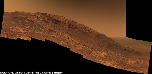
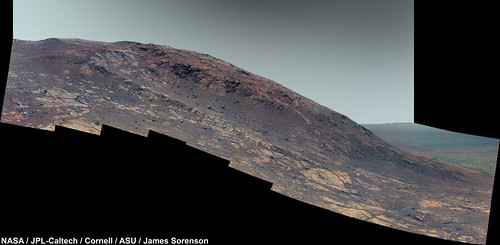
Here's what looks most like a gulley to my geologically untrained eye on Cape Byron - this is at its northern reaches:
|
|
|
|
|
|
|
Aug 6 2016, 03:09 PM
Post
#313
|
|
|
Member Group: Members Posts: 923 Joined: 10-November 15 Member No.: 7837 |
Hey Fredk, small bump for my Marathon Valley model focused on Gibraltar II region.
Marathon Valley Gibraltar II location focus @ Sketchfab I've also updated the viewer scale when viewing in VR...Sketchfab has made some excellent updates recently, making VR access easier. -------------------- |
|
|
|
|
Aug 9 2016, 11:37 PM
Post
#314
|
|||
|
Member Group: Members Posts: 866 Joined: 15-March 05 From: Santa Cruz, CA Member No.: 196 |
thanks so much for that, Sean! it is so much better than muddling around with GoogleEarth. Fredk'S POI is at left in this snapshot with a view to Marathon opening at furthest reaches past the dark hump of Cape Tribulation, so we'd come out the spring chute a bit upcrater of that area it seems. I'd thought the apparent fluidly-disturbed area was a just surficial effect of modern wind-driven erosion, but my untrained eye shall suspend its disbelief.. it looks more like an ancient deeply-etched feature the more i look at it.
Just a month or two ago we were going to head out to traverse the crater rim, but now this is great news to be traversing inside the rim, still, I couldn't quite wrap my head around why the PS update suggests that they did not go down Marathon Valley all the way into Endeavor, because "it would be likely one way", even though it also mentions there is an exit route from inside and they do plan to check out mega-ripples anyway, as I can't see any blockage that may explain the opening of Marathon to the floor vs where the spring exit route seems to suggest both have smooth paths south from what i can tell, maybe they are just afraid of getting stuck in potential purgatories that may lurk within the basin? |
||
|
|
|
||
|
Aug 21 2016, 02:11 PM
Post
#315
|
||
|
Senior Member Group: Members Posts: 2817 Joined: 22-April 05 From: Ridderkerk, Netherlands Member No.: 353 |
The Navcam L0 view on Sol 4459 and Sol 4460.
Jan van Driel
|
|
|
|
|
|
|

|
Lo-Fi Version | Time is now: 19th April 2024 - 03:11 PM |
|
RULES AND GUIDELINES Please read the Forum Rules and Guidelines before posting. IMAGE COPYRIGHT |
OPINIONS AND MODERATION Opinions expressed on UnmannedSpaceflight.com are those of the individual posters and do not necessarily reflect the opinions of UnmannedSpaceflight.com or The Planetary Society. The all-volunteer UnmannedSpaceflight.com moderation team is wholly independent of The Planetary Society. The Planetary Society has no influence over decisions made by the UnmannedSpaceflight.com moderators. |
SUPPORT THE FORUM Unmannedspaceflight.com is funded by the Planetary Society. Please consider supporting our work and many other projects by donating to the Society or becoming a member. |
|