SpaceIL lunar lander mission - 2019 |

SpaceIL lunar lander mission - 2019 |
 Sep 13 2018, 06:21 AM Sep 13 2018, 06:21 AM
Post
#1
|
|
|
Solar System Cartographer  Group: Members Posts: 10159 Joined: 5-April 05 From: Canada Member No.: 227 |
I'm setting this up in preparation for the launch of SpaceIL's lunar mission, probably early next year. They have arranged a rideshare with Spaceflight Industries on a Falcon 9 launch early in 2019. Earlier they were saying launch in December, land on the Moon in February, so now I assume the landing might be delayed until March. This mission was originally going to be part of the Google Lunar X Prize, but that of course is now gone. It might be rekindled with a different sponsor (though I doubt it).
SpaceIL is the first of the GLXP teams to actually make it to a launch. For what it's worth, I expect Astrobotic to fly as well, and I think Team Indus and PTScientists may also get off the ground. I'm hearing things about Moon Express which cause me to doubt its chances. More on landing sites shortly. Phil -------------------- ... because the Solar System ain't gonna map itself.
Also to be found posting similar content on https://mastodon.social/@PhilStooke Maps for download (free PD: https://upload.wikimedia.org/wikipedia/comm...Cartography.pdf NOTE: everything created by me which I post on UMSF is considered to be in the public domain (NOT CC, public domain) |
 |
 
|
 |
|
Apr 15 2019, 03:44 AM
Post
#2
|
|
|
Solar System Cartographer Group: Members Posts: 10159 Joined: 5-April 05 From: Canada Member No.: 227 |
"https://www.reddit.com/r/space/comments/bd34il/hi_my_name_is_ben_nathaniel_i_work_on_the_team_of/"
Reddit has this 'ask me anything' with a spaceIL team member. Among other things it confirms that the Hypatia image was taken 4 hours before the landing attempt (2 orbits earlier). I suspect that the Lacus Mortis image was taken on that orbit or the next. I don't think it can be from the descent, so I don't think a path can be mapped from the image location to the landing site. The time of image release is not indicative of when it was taken. The Reddit does say that there is another image not yet released, possibly from the actual descent. It also appears that there is some magnetometer data taken and probably on the ground. Phil -------------------- ... because the Solar System ain't gonna map itself.
Also to be found posting similar content on https://mastodon.social/@PhilStooke Maps for download (free PD: https://upload.wikimedia.org/wikipedia/comm...Cartography.pdf NOTE: everything created by me which I post on UMSF is considered to be in the public domain (NOT CC, public domain) |
|
|
|
|
Apr 15 2019, 06:19 PM
Post
#3
|
|||
 Junior Member Group: Members Posts: 31 Joined: 24-February 17 From: California Member No.: 8127 |
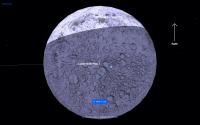
QUOTE (Phil Stooke @ Apr 14 2019, 08:44 PM)  "https://www.reddit.com/r/space/comments/bd34il/hi_my_name_is_ben_nathaniel_i_work_on_the_team_of/" Reddit has this 'ask me anything' with a spaceIL team member. Among other things it confirms that the Hypatia image was taken 4 hours before the landing attempt (2 orbits earlier). I suspect that the Lacus Mortis image was taken on that orbit or the next. I don't think it can be from the descent, so I don't think a path can be mapped from the image location to the landing site. The time of image release is not indicative of when it was taken. The Reddit does say that there is another image not yet released, possibly from the actual descent. It also appears that there is some magnetometer data taken and probably on the ground. Phil I agree. I found Beresheet's orbit telemetry which was updated up to the point where Beresheet flew over the lunar north polar area on April 11, before the descent sequence started. Here is the link (browser OpenGL support required to view the animation): https://live.spaceil.com/ When you play the simulation, the simulation at the end stops on April 11. It is also obvious that Beresheet was west of the lunar north pole on April 11 when it came into view from Earth. Given that Beresheet's polar orbit passes approximately 8 degrees west of the lunar north pole as seen from Earth, there is no way that the selfie shown during the live broadcast could have been later than the photo of Hypatia which was shown earlier during the live broadcast. Thus it seems that the selfie photo shown live must have been taken at least a few to several orbits before the Hypatia image was taken. I don't know why SpaceIL chose to show these two photos during the live broadcast since everyone assumed that these photos were live from the spacecraft, in particular, the selfie photo.
Attached thumbnail(s)
|
||
|
|
|
||
 Phil Stooke SpaceIL lunar lander mission - 2019 Sep 13 2018, 06:21 AM
 Phil Stooke The lander will carry a magnetometer, and landing ... Sep 13 2018, 07:09 PM Phil Stooke This illustration shows the sites suggested for Sp... Sep 23 2018, 05:49 PM nprev Interesting. Kinda makes me wonder if they're ... Sep 24 2018, 03:48 AM Phil Stooke SpaceIL has been running a lander name competition... Oct 30 2018, 11:46 PM Phil Stooke A very nice update on SpaceIL at the Planetary Soc... Nov 8 2018, 05:13 PM Phil Stooke Follow-on to the naming story - SpaceIL has just t... Dec 13 2018, 08:05 AM Phil Stooke This is the new SpaceIL landing area. Launch now ... Dec 18 2018, 09:29 PM
 SpaceListener QUOTE (Phil Stooke @ Dec 18 2018, 03:29 P... Dec 18 2018, 09:41 PM
 Thorsten Denk QUOTE (Phil Stooke @ Dec 18 2018, 10:29 P... Dec 28 2018, 12:19 PM Phil Stooke You are referring to the scale of the map, and as ... Dec 18 2018, 09:48 PM SpaceListener To refresh news from SpaceIL
http://www.moondaily... Dec 19 2018, 05:33 PM Thorsten Denk Launch of SpaceIL's Beresheet Lunar Lander nex... Feb 19 2019, 08:41 AM Thorsten Denk Somewhere (I don't find it anymore )
I read t... Feb 21 2019, 08:26 AM Paolo there is a good recap of the mission on the Nature... Feb 21 2019, 10:45 AM nprev SpaceIL has successfully separated from the Falcon... Feb 22 2019, 02:21 AM Phil Stooke This LPSC abstract:
http://www.hou.usra.edu/meeti... Feb 22 2019, 02:51 AM Thorsten Denk On this page live.spaceil.com there is a simulatio... Feb 23 2019, 05:27 PM SpaceListener News from today, the SpaceIL has failed with the s... Feb 28 2019, 08:22 PM Explorer1 Looks like the maneuver was redone and went fine, ... Feb 28 2019, 08:58 PM kenny Beresheet has conducted its fourth engine firing, ... Mar 20 2019, 11:30 AM SpaceListener Now Beresheet is reaching the fourth apogee earth ... Mar 20 2019, 03:19 PM kenny I think it will stay in this Earth orbit, its fina... Mar 20 2019, 07:23 PM SpaceListener The spaceship: Beresheet is about two days away to... Apr 2 2019, 03:42 PM Phil Stooke This is the landing area. The 'Aharonson et a... Apr 4 2019, 12:06 AM SpaceListener The Bereshet was already captured by the Moon... Apr 4 2019, 04:00 PM Steve G A couple of pics from the far side available on IL... Apr 5 2019, 08:49 PM Explorer1 https://www.youtube.com/watch?v=HMdUcchBYRA
Some ... Apr 11 2019, 07:10 PM B Bernatchez Any idea when/if LRO will be imaging the landing s... Apr 11 2019, 07:13 PM Explorer1 Looks like the main engine failed, and they lost c... Apr 11 2019, 07:28 PM algorithm Controlled landing unssucessful, main engine failu... Apr 11 2019, 07:29 PM algorithm Final telemetry
Apr 11 2019, 07:42 PM Hungry4info From this tweet.
QUOTE Just received from SpaceIL... Apr 11 2019, 08:02 PM Thorsten Denk Just wondering if Phil Stooke will identify the cr... Apr 11 2019, 09:25 PM JRehling I have to say, it somewhat alarmed me to see that ... Apr 12 2019, 01:26 AM GoneToPlaid QUOTE (Hungry4info @ Apr 11 2019, 01:02 P... Apr 14 2019, 03:48 AM marsbug Well done to them - as I understand it this was fa... Apr 11 2019, 10:05 PM Explorer1 Yeah, Phil will definitely identify the craters... Apr 11 2019, 10:14 PM Thorsten Denk The crater should be Hypatia A.
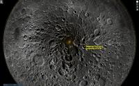
looking North East... Apr 11 2019, 10:32 PM Phil Stooke Here's the first image, reprojected a bit to h... Apr 11 2019, 11:41 PM Phil Stooke And the second. As was said already, it's Hyp... Apr 11 2019, 11:49 PM John Whitehead On April 5, Space News reported that the lander fi... Apr 12 2019, 05:59 AM Xerxes QUOTE (John Whitehead @ Apr 12 2019, 12:5... Apr 12 2019, 02:17 PM Paolo any idea whether the expected magnetometer data to... Apr 13 2019, 06:46 AM Phil Stooke News today:
Leonard David reports LRO's LOLA... Apr 13 2019, 06:43 PM GoneToPlaid Hypatia A
Here is a LRO QuickMap link to match th... Apr 14 2019, 04:07 AM GoneToPlaid Beresheet's last photo...
My correctly orient... Apr 14 2019, 04:12 AM GoneToPlaid LRO QuickMap 2D and 3D screen captures, and QuickM... Apr 14 2019, 04:31 AM GoneToPlaid The terrain from Beresheet's last selfie photo... Apr 14 2019, 04:33 AM Thorsten Denk Just two questions:
Was the (final) orbit perfectl... Apr 15 2019, 06:50 AM Phil Stooke See the LRO presentation at LEAG last year linked ... Apr 15 2019, 04:34 PM GoneToPlaid QUOTE (Phil Stooke @ Apr 15 2019, 09:34 A... Apr 15 2019, 06:51 PM Phil Stooke You are right! I had mis-remembered that pres... Apr 15 2019, 10:56 PM Thorsten Denk There is a new "final picture" from Bere... Apr 17 2019, 02:48 PM Explorer1 From their Twitter feed: "Here are the findin... Apr 17 2019, 07:18 PM charborob Beresheet Crash Site Spotted! May 15 2019, 02:35 PM Phil Stooke Yes indeed! Here's a finder map for the c... May 15 2019, 05:52 PM Thorsten Denk Seems there will be no Beresheet-2 on the Moon. ... Jun 27 2019, 11:05 AM JRehling It turns out this crash may have added some tardig... Aug 10 2019, 01:17 AM Phil Stooke There has been a lot of chatter about tardigrades ... Aug 10 2019, 06:00 AM marsbug From what I read they can, in their hibernated pt... Aug 11 2019, 11:08 AM Explorer1 QUOTE (marsbug @ Aug 11 2019, 07:08 AM) A... Aug 11 2019, 03:26 PM marsbug Ok, hang on: The tardigrades are.in their 'sa... Aug 11 2019, 04:45 PM JRehling It seems like a decent future mission would be to ... Aug 11 2019, 05:01 PM Thorsten Denk QUOTE (JRehling @ Aug 11 2019, 07:01 PM) ... Aug 11 2019, 07:45 PM marsbug It's not my field so I cannot vouch for it, bu... Aug 11 2019, 08:08 PM Phil Stooke I don't have the time or the desire to investi... Aug 26 2019, 09:54 PM JRehling Near absolute zero, aren't a few minutes and a... Aug 27 2019, 04:24 AM marsbug This is soooo not my area of expertise, but a wee ... Aug 27 2019, 03:12 PM nprev Might be time to stop beating a dead tardigrade he... Aug 28 2019, 01:05 AM marsbug I've just started teacher training (physics), ... Aug 30 2019, 10:30 AM Phil Stooke The LPSC 2020 abstracts are available now (Jan. 31... Jan 31 2020, 08:55 PM Explorer1 So even if landing was successful, there would not... Jan 31 2020, 09:43 PM
Thorsten Denk QUOTE (Phil Stooke @ Dec 18 2018, 10:29 P... Dec 28 2018, 12:19 PM Phil Stooke You are referring to the scale of the map, and as ... Dec 18 2018, 09:48 PM SpaceListener To refresh news from SpaceIL
http://www.moondaily... Dec 19 2018, 05:33 PM Thorsten Denk Launch of SpaceIL's Beresheet Lunar Lander nex... Feb 19 2019, 08:41 AM Thorsten Denk Somewhere (I don't find it anymore )
I read t... Feb 21 2019, 08:26 AM Paolo there is a good recap of the mission on the Nature... Feb 21 2019, 10:45 AM nprev SpaceIL has successfully separated from the Falcon... Feb 22 2019, 02:21 AM Phil Stooke This LPSC abstract:
http://www.hou.usra.edu/meeti... Feb 22 2019, 02:51 AM Thorsten Denk On this page live.spaceil.com there is a simulatio... Feb 23 2019, 05:27 PM SpaceListener News from today, the SpaceIL has failed with the s... Feb 28 2019, 08:22 PM Explorer1 Looks like the maneuver was redone and went fine, ... Feb 28 2019, 08:58 PM kenny Beresheet has conducted its fourth engine firing, ... Mar 20 2019, 11:30 AM SpaceListener Now Beresheet is reaching the fourth apogee earth ... Mar 20 2019, 03:19 PM kenny I think it will stay in this Earth orbit, its fina... Mar 20 2019, 07:23 PM SpaceListener The spaceship: Beresheet is about two days away to... Apr 2 2019, 03:42 PM Phil Stooke This is the landing area. The 'Aharonson et a... Apr 4 2019, 12:06 AM SpaceListener The Bereshet was already captured by the Moon... Apr 4 2019, 04:00 PM Steve G A couple of pics from the far side available on IL... Apr 5 2019, 08:49 PM Explorer1 https://www.youtube.com/watch?v=HMdUcchBYRA
Some ... Apr 11 2019, 07:10 PM B Bernatchez Any idea when/if LRO will be imaging the landing s... Apr 11 2019, 07:13 PM Explorer1 Looks like the main engine failed, and they lost c... Apr 11 2019, 07:28 PM algorithm Controlled landing unssucessful, main engine failu... Apr 11 2019, 07:29 PM algorithm Final telemetry
Apr 11 2019, 07:42 PM Hungry4info From this tweet.
QUOTE Just received from SpaceIL... Apr 11 2019, 08:02 PM Thorsten Denk Just wondering if Phil Stooke will identify the cr... Apr 11 2019, 09:25 PM JRehling I have to say, it somewhat alarmed me to see that ... Apr 12 2019, 01:26 AM GoneToPlaid QUOTE (Hungry4info @ Apr 11 2019, 01:02 P... Apr 14 2019, 03:48 AM marsbug Well done to them - as I understand it this was fa... Apr 11 2019, 10:05 PM Explorer1 Yeah, Phil will definitely identify the craters... Apr 11 2019, 10:14 PM Thorsten Denk The crater should be Hypatia A.
looking North East... Apr 11 2019, 10:32 PM Phil Stooke Here's the first image, reprojected a bit to h... Apr 11 2019, 11:41 PM Phil Stooke And the second. As was said already, it's Hyp... Apr 11 2019, 11:49 PM John Whitehead On April 5, Space News reported that the lander fi... Apr 12 2019, 05:59 AM Xerxes QUOTE (John Whitehead @ Apr 12 2019, 12:5... Apr 12 2019, 02:17 PM Paolo any idea whether the expected magnetometer data to... Apr 13 2019, 06:46 AM Phil Stooke News today:
Leonard David reports LRO's LOLA... Apr 13 2019, 06:43 PM GoneToPlaid Hypatia A
Here is a LRO QuickMap link to match th... Apr 14 2019, 04:07 AM GoneToPlaid Beresheet's last photo...
My correctly orient... Apr 14 2019, 04:12 AM GoneToPlaid LRO QuickMap 2D and 3D screen captures, and QuickM... Apr 14 2019, 04:31 AM GoneToPlaid The terrain from Beresheet's last selfie photo... Apr 14 2019, 04:33 AM Thorsten Denk Just two questions:
Was the (final) orbit perfectl... Apr 15 2019, 06:50 AM Phil Stooke See the LRO presentation at LEAG last year linked ... Apr 15 2019, 04:34 PM GoneToPlaid QUOTE (Phil Stooke @ Apr 15 2019, 09:34 A... Apr 15 2019, 06:51 PM Phil Stooke You are right! I had mis-remembered that pres... Apr 15 2019, 10:56 PM Thorsten Denk There is a new "final picture" from Bere... Apr 17 2019, 02:48 PM Explorer1 From their Twitter feed: "Here are the findin... Apr 17 2019, 07:18 PM charborob Beresheet Crash Site Spotted! May 15 2019, 02:35 PM Phil Stooke Yes indeed! Here's a finder map for the c... May 15 2019, 05:52 PM Thorsten Denk Seems there will be no Beresheet-2 on the Moon. ... Jun 27 2019, 11:05 AM JRehling It turns out this crash may have added some tardig... Aug 10 2019, 01:17 AM Phil Stooke There has been a lot of chatter about tardigrades ... Aug 10 2019, 06:00 AM marsbug From what I read they can, in their hibernated pt... Aug 11 2019, 11:08 AM Explorer1 QUOTE (marsbug @ Aug 11 2019, 07:08 AM) A... Aug 11 2019, 03:26 PM marsbug Ok, hang on: The tardigrades are.in their 'sa... Aug 11 2019, 04:45 PM JRehling It seems like a decent future mission would be to ... Aug 11 2019, 05:01 PM Thorsten Denk QUOTE (JRehling @ Aug 11 2019, 07:01 PM) ... Aug 11 2019, 07:45 PM marsbug It's not my field so I cannot vouch for it, bu... Aug 11 2019, 08:08 PM Phil Stooke I don't have the time or the desire to investi... Aug 26 2019, 09:54 PM JRehling Near absolute zero, aren't a few minutes and a... Aug 27 2019, 04:24 AM marsbug This is soooo not my area of expertise, but a wee ... Aug 27 2019, 03:12 PM nprev Might be time to stop beating a dead tardigrade he... Aug 28 2019, 01:05 AM marsbug I've just started teacher training (physics), ... Aug 30 2019, 10:30 AM Phil Stooke The LPSC 2020 abstracts are available now (Jan. 31... Jan 31 2020, 08:55 PM Explorer1 So even if landing was successful, there would not... Jan 31 2020, 09:43 PM |

|
Lo-Fi Version | Time is now: 7th May 2024 - 01:00 AM |
|
RULES AND GUIDELINES Please read the Forum Rules and Guidelines before posting. IMAGE COPYRIGHT |
OPINIONS AND MODERATION Opinions expressed on UnmannedSpaceflight.com are those of the individual posters and do not necessarily reflect the opinions of UnmannedSpaceflight.com or The Planetary Society. The all-volunteer UnmannedSpaceflight.com moderation team is wholly independent of The Planetary Society. The Planetary Society has no influence over decisions made by the UnmannedSpaceflight.com moderators. |
SUPPORT THE FORUM Unmannedspaceflight.com is funded by the Planetary Society. Please consider supporting our work and many other projects by donating to the Society or becoming a member. |
|