Live Dust Devil? |

  |
Live Dust Devil? |
 Mar 11 2005, 10:56 PM Mar 11 2005, 10:56 PM
Post
#61
|
|
 Senior Member  Group: Members Posts: 1281 Joined: 18-December 04 From: San Diego, CA Member No.: 124 |
They missed a spot.

-------------------- Lyford Rome
"Zis is not nuts, zis is super-nuts!" Mathematician Richard Courant on viewing an Orion test |
 |
 
|
|
Mar 11 2005, 11:03 PM
Post
#62
|
|
|
Member Group: Members Posts: 295 Joined: 2-March 04 From: Central California Member No.: 45 |
I think this is the path the dust devil took...

-------------------- Eric P / MizarKey
|
|
|
|
|
Mar 11 2005, 11:07 PM
Post
#63
|
|
 Member Group: Members Posts: 710 Joined: 28-September 04 Member No.: 99 |
Sol 377:
 Sol 422:  Notice the magnet to the right of the sundial. Most of the dust is now on the right side of the 'ring'!
|
|
|
|
|
Mar 11 2005, 11:08 PM
Post
#64
|
|
 Senior Member Group: Members Posts: 1887 Joined: 20-November 04 From: Iowa Member No.: 110 |
Some images of the ground
Before (sol 398) http://marsrovers.jpl.nasa.gov/gallery/all...00P1312R0M1.JPG After (sol 421) http://marsrovers.jpl.nasa.gov/gallery/all...90P1212R0M1.JPG |
|
|
|
|
Mar 12 2005, 12:00 AM
Post
#65
|
|
|
Senior Member Group: Members Posts: 1887 Joined: 20-November 04 From: Iowa Member No.: 110 |
The dust devil cleaned many of the rocks too. Should be a good time to use the Mini-TES.
|
|
|
|
|
Mar 12 2005, 12:02 AM
Post
#66
|
||
 Member Group: Members Posts: 257 Joined: 18-December 04 Member No.: 123 |
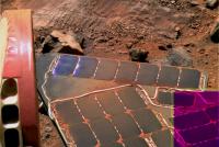
Well, given the occasion I felt that it was worth trying to make one of these colour image jobbies just so I could look for myself at what happened.
Here's my first comby, I apologise to any image connoisseurs out there, perhaps it might be best to avert your eyes!!  I'll leave it to the experts from now on I think. It's always nice to dabble though. I'll leave it to the experts from now on I think. It's always nice to dabble though. Who would have thought clumps of dirt could look so good on solar panels. It's becoming quite the fashion statement on Mars it seems... 
Attached thumbnail(s)
-------------------- Turn the middle side topwise....TOPWISE!!
|
|
|
|
|
|
|
Mar 12 2005, 12:38 AM
Post
#67
|
|
|
Founder Group: Chairman Posts: 14431 Joined: 8-February 04 Member No.: 1 |
Interesting thing if you look at this
http://themis-data.asu.edu/img/V07909002.html Many of the dust devil tracks ( particularly one ENORMOUS one starting left edge of centre ) start at a crater - or perhaps the northern rim of a crater. Maybe being in a slight wind 'shadow' allows the air pocket inside the crater to warm up faster in the morning, rise, draw air in down the crater walls and it cycles from there. Perhaps this is why Opportunity got cleaned so well? If you look closely - some devils start AT the columbia hills - perhaps a north facing slope playing the same roll as the crater - being a trigger point. Any glider pilot will tell you - a sun-facing slope is often a good trigger for thermals Doug |
|
|
|
|
Mar 12 2005, 01:20 AM
Post
#68
|
|
|
Forum Contributor Group: Members Posts: 1372 Joined: 8-February 04 From: North East Florida, USA. Member No.: 11 |
I noticed a long time ago too that a lot of streaks started at a crater. I have glided before but just on a winch, not hill soaring.
|
|
|
|
|
Mar 12 2005, 01:26 AM
Post
#69
|
|
|
Member Group: Members Posts: 180 Joined: 31-January 05 From: Brittany (France) Member No.: 164 |
I guess you are right, Doug, explaining Dust Devils in terms of topography. One may compare "Dust Devils alley" area from Themis image you linked with the strongly amplified MOLA datas for Spirit landing site linked below (each square 463m; each color: 20m elevation): most Dust Devils are likely linked with an elevated area extending between White Hill and Castril crater:

-------------------- Erwann |
|
|
|
|
Mar 12 2005, 01:53 AM
Post
#70
|
|
|
Member Group: Members Posts: 180 Joined: 31-January 05 From: Brittany (France) Member No.: 164 |
A few more explanation words: The (cream color) elevated area (given Eastward Gusev rim) is likely to be sooner sun heated on the early morning than neighbouring areas (blue or grey)....
-------------------- Erwann |
|
|
|
|
Mar 12 2005, 02:51 AM
Post
#71
|
|
|
Senior Member Group: Members Posts: 1870 Joined: 20-February 05 Member No.: 174 |
tedstryk commented:
"The Viking 1 lander died in a very sad way. A young controller sent an erant command shutting it down in 1982 - it may well have lived into the 1990s had this not happened." To set the record straight. The Viking Landers were powered by Radioisotope Thermoelectric Generators, but their instantaneous power demands when they were *doing* anything were greater than the RTG's could supply. They had to draw on rechargable batteries when they were transmitting, recording data to the tape recorder, etc. Also note that the Landers primary communications to Earth was by relay to the Viking Orbiters, and secondarily by direct uplink to Earth. Viking Orbiter 2 died of attitude control gas depletion after 2 years in Mars Orbit, while Viking Orbiter 1 lasted 4 years. Viking Lander 2 died of battery failure just a few weeks before the loss of Orbiter 1. It would try to do *ANYTHING*, have a brownout, and go into a safemode. I believe they finally sent it a final shutdown command sequence. Lander 2 had both transmitters to Earth fail, and could only communicate through an Obiter, so it would have been silenced by the loss of the last Orbiter. Viking 1 was put on a 1-transmission-per-week (direct to Earth) "eternal" mission and lasted 2 1/3 more years till it started to show signs of battery failure. They assembled an "impromptu" team to write battery conditioning software and uplinked a command sequence to the Lander. It was never heard from again. They believe the command sequence accidentally overwrote the code that predicted Earth's location in the sky for the antenna pointing. They attempted to uplink corrected code, but either the Lander never received the corrections, or the batteries had in fact failed. Viking started the sad example of repeat crisises regarding termination of a live mission. After the first "Extended" mission, there was a further "Extended" Mission, (I think), then a "Completion" mission, after which things wouild be shut down. That was averted and Orbiter 1 did a "Survey" Mission of very simple large area contiguous mapping. Finally, with the orbiter's loss, Lander 1 was put on it's "Eternal" (don't recall if there was an official name or not) mission. They were only able to listen sporadically to it's automatic broadcasts: Voyagers and some other missions were doing their things and there was essentially no $ for the effort. |
|
|
|
|
Mar 12 2005, 04:04 AM
Post
#72
|
|
|
Senior Member Group: Members Posts: 1870 Joined: 20-February 05 Member No.: 174 |
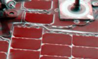
I took the pre and post cleaning images posted earlier today, and combined them into a pseudo-color image: the pre-dusting frame as red, the post-dusting frame as blue, and their average as green.
Sun-angles are close but not identical, and the images are not in perfect registration, but the result is interesting. Areas with the most dust removed (actually the greatest reflectance change) are red. You can trace the changes even into shadowed areas. Some of the misc. metal hardware in the upper left corner shows little if any real change (other than mis-registration fringes). Dust tails behind pieces of hardware appear grayer, as there's been little brightness change. A steplike edge of metal hardware in the center of the left edge of the image may have accumulated dust, or that may be due to the change in illumination. |
|
|
|
|
Mar 12 2005, 04:05 AM
Post
#73
|
||
|
Senior Member Group: Members Posts: 1870 Joined: 20-February 05 Member No.: 174 |
Uh... It would help if I added the pic before hitting "add reply"...
Attached thumbnail(s)
|
|
|
|
|
|
| Guest_RGClark_* |
Mar 12 2005, 06:56 AM
Post
#74
|
|
Guests |
QUOTE (Sunspot @ Mar 11 2005, 12:20 AM) it seems to extend in to the atmosphere:  Thanks for that image, Sunspot. If it's that big maybe we should call it a tornado rather than a dust devil. Anyone want to estimate its width at the base? Bob Clark |
|
|
|
|
Mar 12 2005, 10:14 AM
Post
#75
|
|
|
Founder Group: Chairman Posts: 14431 Joined: 8-February 04 Member No.: 1 |
Half the size of lahontan crater? Call it 30ft across maybe?
Doug |
|
|
|
|

|
Lo-Fi Version | Time is now: 19th April 2024 - 01:09 PM |
|
RULES AND GUIDELINES Please read the Forum Rules and Guidelines before posting. IMAGE COPYRIGHT |
OPINIONS AND MODERATION Opinions expressed on UnmannedSpaceflight.com are those of the individual posters and do not necessarily reflect the opinions of UnmannedSpaceflight.com or The Planetary Society. The all-volunteer UnmannedSpaceflight.com moderation team is wholly independent of The Planetary Society. The Planetary Society has no influence over decisions made by the UnmannedSpaceflight.com moderators. |
SUPPORT THE FORUM Unmannedspaceflight.com is funded by the Planetary Society. Please consider supporting our work and many other projects by donating to the Society or becoming a member. |
|