HRSCview, New online HRSC image viewer |

  |
HRSCview, New online HRSC image viewer |
 May 21 2007, 10:16 AM May 21 2007, 10:16 AM
Post
#16
|
|
 Special Cookie  Group: Members Posts: 2168 Joined: 6-April 05 From: Sintra | Portugal Member No.: 228 |
Some Deuteronilus Mensae goodies...

-------------------- "Ride, boldly ride," The shade replied, "If you seek for Eldorado!"
Edgar Alan Poe |
 |
 
|
|
Jan 1 2008, 04:41 PM
Post
#17
|
||
|
Founder Group: Chairman Posts: 14432 Joined: 8-February 04 Member No.: 1 |
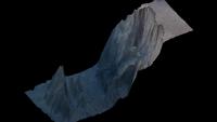
At the HRSCView site, they now have a downloadable IDL VM tool - and if you download the complete set of level 4's for an observation, you can do some primative processing yourself.
It includes a perspective viewer - which can do things like the attached. It has an export-to-vrml option, but the VRML's it produces are enormous files that no application I can find can use. If only...if only I could get these HRSC DEM's into 3ds max  Doug
Attached thumbnail(s)
|
|
|
|
|
|
|
Jan 4 2008, 11:22 PM
Post
#18
|
||||
|
Founder Group: Chairman Posts: 14432 Joined: 8-February 04 Member No.: 1 |
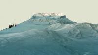
Lady's and Gentlemen....bingo.
Emily was kind enough to put me in touch with Greg Michael who, within 24 hours, had an IDL script on the HRSCView website ( http://hrscview.fu-berlin.de/software.html - bottom of ) to export 8 bit tif's of all the imaging channels, and a 16bit tif of the DEM. As a result - the attached out of 3ds max. And yes - a movie is rendering right now 720p, it'll be done by the end of tomorrow.Doug
Attached thumbnail(s)
|
|||
|
|
|
|||
|
Jan 5 2008, 12:32 AM
Post
#19
|
|
 Senior Member Group: Members Posts: 1281 Joined: 18-December 04 From: San Diego, CA Member No.: 124 |
Um, OMG?!?!?!?
 It's like UMSF is a massively parallel networked system a la SETI@home, except instead of sharing CPU cycles it channels "enthusiast resources" to create TEH MOST AWESOMEST IMAGERY EVER!!!* I am so glad to be part of this board... *If you can't take the hint, this was supposed to get you to post the movie, Doug. 
-------------------- Lyford Rome
"Zis is not nuts, zis is super-nuts!" Mathematician Richard Courant on viewing an Orion test |
|
|
|
|
Jan 5 2008, 08:08 AM
Post
#20
|
|
 The Poet Dude Group: Moderator Posts: 5551 Joined: 15-March 04 From: Kendal, Cumbria, UK Member No.: 60 |
Wow Doug, I genuinely felt a shiver run up my spine when I saw those images... this is the kind of breakthrough that really could help to show non space- and Mars-enthusiasts that Mars is a real world, with alien but strangely-familiar landscapes. When I highlighted those "MRO perspective views" a few days ago I fully expected someone to post a "They look great, but actually they are vertically exaggerated" reply, because they just look 'wrong' to me somehow (I'm sure they're not, it's just me!) but those images of yours look like the view through a spacecraft window... just stunning... thank you! I can't wait to see how this evolves.
We may just have found the door to a martian Narnia...
-------------------- |
|
|
|
|
Jan 5 2008, 01:34 PM
Post
#21
|
||
|
Founder Group: Chairman Posts: 14432 Joined: 8-February 04 Member No.: 1 |
Not sure on the vert exag myself with these yet. Thing is - the really big features (like Oly Mons) look crap without vertical exaggeration.
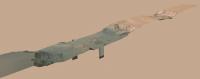
I'll try and do something to explain how I'm doing them - but I actually end up with two noodles for the data. One is a low res version which I actually have in 3d in 3ds max, maybe 200 x 1000 polygons, displaced by the elevation tif. Then, there is a flat surface, which is also displaced by the tif, but in the rendering process - at it's full res, so it emulates the full res of the tif, maybe 8 million points ( 1000 x 8000 for example ). To have the 8 million polys in real time would be murder to animate - so I drop a blank blue texture on my low res version and put it directly on top of the 'real' one. I keep increasing the displacement of the low res one until it matches (as they're displaced using different techniques they don't work exactly the same) - by rendering and re-rendering until the high res displacement, and the low res blue just about match. THEN - I can set the blue to be none-rendered, but use it as a guide for animating the camera over. As a result, I'm not entirely sure of the vertical elevation I'm getting. What I'll have to do is make a simple box with the length, width, and total height of the terrain from highest to lowest point - and then fit the other two to match it. I think. Doug
Attached thumbnail(s)
|
|
|
|
|
|
|
Jan 5 2008, 03:00 PM
Post
#22
|
|
|
Founder Group: Chairman Posts: 14432 Joined: 8-February 04 Member No.: 1 |
Low res ( 3 meg) and High Res ( 9 meg ) available here
http://www.rlproject.com/HRSC/2039 H264 Quicktimes - the low res should play on anything, the high res, you might need a bit of grunt. FYI - the render of 500 frames took 3hrs 20 mins on a Quad Core 3Ghz machine with 4 Gig of Ram running Win XP 64. Doug |
|
|
|
|
Jan 5 2008, 03:23 PM
Post
#23
|
|
 Junior Member Group: Members Posts: 53 Joined: 10-September 05 Member No.: 492 |
Great stuff, Doug! The hi res runs perfectly on my fairly modest desktop so shouldn't be a problem for most.
Pity the strip is so narrow, seeing the edges takes away some of the feeling of 'immersion' (unless there is some way for me to zoom in with my viewer). Are you planning any other (ie not straight down the middle) fly-throughs? (*Not* wishing to sound ungrateful -just that you've whetted my appetite for more!) This really is tremendous - thanks for sharing! Rob |
|
|
|
|
Jan 5 2008, 03:49 PM
Post
#24
|
|
|
Founder Group: Chairman Posts: 14432 Joined: 8-February 04 Member No.: 1 |
That's the challenge, the data is taken in ribbons (push broom) and thus that's one observation.
I'm currently working on putting two observations in a mosaic ( by doing a mosaic of the imagery first, then simply having one terrain object in 3ds max ) which will, instead of being something like 10,000 pixels long and a 1000 across, be more like 3000 across and 6000 long (380_0001 and 420_0001) They will always have the feel of looking 'at' a product rather than being in it - simply because it will fall apart if the camera is too close (low resolution). Doug |
|
|
|
|
Jan 5 2008, 09:28 PM
Post
#25
|
|
|
Senior Member Group: Members Posts: 2920 Joined: 14-February 06 From: Very close to the Pyrénées Mountains (France) Member No.: 682 |
Whouaouh ! Father Christmass is late, but what a present !
Thanks Doug -------------------- |
|
|
|
|
Jan 5 2008, 11:56 PM
Post
#26
|
|
 Member Group: Members Posts: 710 Joined: 28-September 04 Member No.: 99 |
QUOTE (djellison @ Jan 5 2008, 04:49 PM)  They will always have the feel of looking 'at' a product rather than being in it - simply because it will fall apart if the camera is too close (low resolution). Here's an idea: Put the camera right on the edge of a cliff and let the camera pan around into the valley like the viewer in Midnight Mars Browser. That should be spectacular, and I'm guessing the camera will still be far away enough from the valley floor... |
|
|
|
|
Jan 6 2008, 12:02 AM
Post
#27
|
|
|
Merciless Robot Group: Admin Posts: 8783 Joined: 8-December 05 From: Los Angeles Member No.: 602 |
The high-res didn't work for me (got a plug-in error), but the low-res did...and that was enough. Damn!
 Thanks, Doug; a very nice gift to us all!
-------------------- A few will take this knowledge and use this power of a dream realized as a force for change, an impetus for further discovery to make less ancient dreams real.
|
|
|
|
|
Jan 6 2008, 12:22 AM
Post
#28
|
|
|
Founder Group: Chairman Posts: 14432 Joined: 8-February 04 Member No.: 1 |
Hmm - what you using to play it? You'll need the latest quicktime. (Although VLC might do it) Save it to your desktop and run it from there, don't ask a browser to play it.
Two more tomorrow. One a bit 'soft' on the terrain (a mosaic with the stitching done with the imagery) and a double for Val-Mer (a mosaic of two with the stitching done with the geometry). The problem with MEX is that it really REALLY doesn't orbit at a standard time of day, so no two neigbour noodles will match up at all - even if you tweak all day. In one case, I've got thick fog in Val-Mer, and the stitch has thing fog. A bit hard to handle really. Doug |
|
|
|
|

|
Lo-Fi Version | Time is now: 25th April 2024 - 05:30 PM |
|
RULES AND GUIDELINES Please read the Forum Rules and Guidelines before posting. IMAGE COPYRIGHT |
OPINIONS AND MODERATION Opinions expressed on UnmannedSpaceflight.com are those of the individual posters and do not necessarily reflect the opinions of UnmannedSpaceflight.com or The Planetary Society. The all-volunteer UnmannedSpaceflight.com moderation team is wholly independent of The Planetary Society. The Planetary Society has no influence over decisions made by the UnmannedSpaceflight.com moderators. |
SUPPORT THE FORUM Unmannedspaceflight.com is funded by the Planetary Society. Please consider supporting our work and many other projects by donating to the Society or becoming a member. |
|