T-75 Flyby (April 19, 2011 / Rev 147), All about the magnetosphere |

  |
T-75 Flyby (April 19, 2011 / Rev 147), All about the magnetosphere |
 Apr 16 2011, 12:53 AM Apr 16 2011, 12:53 AM
Post
#1
|
|
 Senior Member  Group: Moderator Posts: 2785 Joined: 10-November 06 From: Pasadena, CA Member No.: 1345 |
Mission description now up (new abbreviated format?): http://saturn.jpl.nasa.gov/files/T-75_508_v41.pdf
A more complete description of images (RGB composite + some near looks at Adiri - did the recent storm wash away any surface coatings?) on the CICLOPS Looking Ahead summary: http://www.ciclops.org/view/6763/Rev147 -------------------- Some higher resolution images available at my photostream: http://www.flickr.com/photos/31678681@N07/
|
 |
 
|
|
Apr 16 2011, 01:16 AM
Post
#2
|
|
|
Merciless Robot Group: Admin Posts: 8783 Joined: 8-December 05 From: Los Angeles Member No.: 602 |
Mike, I beg your indulgence; been awhile since we've seen you exercise your PhD!
 Can you speculate on the chemical nature of the surface coatings that might have been washed away based (I assume) largely on their solubility in liquid methane @ 94K? Can you speculate on the chemical nature of the surface coatings that might have been washed away based (I assume) largely on their solubility in liquid methane @ 94K?Of course, all bets are off if this was truly a methane monsoon; sheer mechanical force presumably would have been enough to scrub pretty much any transient surface deposits. But what if this was the equivalent of, say, a few cm of gentle terrestrial rain without wind? I suspect that we may have seen removal of 17 or so years of fallout products from atmospheric chemosynthesis. -------------------- A few will take this knowledge and use this power of a dream realized as a force for change, an impetus for further discovery to make less ancient dreams real.
|
|
|
|
|
Apr 16 2011, 02:56 AM
Post
#3
|
|
|
Senior Member Group: Moderator Posts: 2785 Joined: 10-November 06 From: Pasadena, CA Member No.: 1345 |
Mr. McGuire: "I want to say one word to you. Just one word."
Benjamin: "Yes, sir." Mr. McGuire: "Are you listening?" Benjamin: "Yes, I am." Mr. McGuire: "Plastics." - The Graduate (1967) (Actually, if I had to bet, it would be some type of polymeric product. Not necessarily tholin, but something else, maybe a highly colored contaminant. PAH's are a possibility, as are longer chain polyphenyls. You would need something that would be hydrocarbon soluble. Water ice (from the crust) and tholins are not soluble in hydrocarbons (methane/ethane).) The really big question is when stuff gets "washed" do the highlands get brighter as the channels get darker? Or do just the channels get darker? Or do just the highlands get brighter? Or do the highlands get darker and the channels get brighter? -------------------- Some higher resolution images available at my photostream: http://www.flickr.com/photos/31678681@N07/
|
|
|
|
|
Apr 16 2011, 03:09 AM
Post
#4
|
|
|
Merciless Robot Group: Admin Posts: 8783 Joined: 8-December 05 From: Los Angeles Member No.: 602 |
That movie was far more prophetic than we knew at the time!
 Thanks, Mike. Thanks, Mike.Man...I think it's going to be a long time before we understand what's going on on Titan. (Global comment...) -------------------- A few will take this knowledge and use this power of a dream realized as a force for change, an impetus for further discovery to make less ancient dreams real.
|
|
|
|
|
Apr 22 2011, 11:06 AM
Post
#5
|
|
|
Senior Member Group: Members Posts: 3516 Joined: 4-November 05 From: North Wales Member No.: 542 |
Exceptionally fine Titan images from this flyby. Here's just one
http://saturn.jpl.nasa.gov/multimedia/imag...7/N00171170.jpg |
|
|
|
|
Apr 22 2011, 12:36 PM
Post
#6
|
|
|
Rover Driver Group: Members Posts: 1015 Joined: 4-March 04 Member No.: 47 |
South polar detached hood/cap/whatever!
http://saturn.jpl.nasa.gov/photos/raw/rawi...?imageID=236696 those violet images look just weird http://saturn.jpl.nasa.gov/photos/raw/rawi...?imageID=236663 |
|
|
|
|
Apr 23 2011, 08:00 AM
Post
#7
|
|||
|
Member Group: Members Posts: 699 Joined: 1-April 08 From: Minnesota ! Member No.: 4081 |
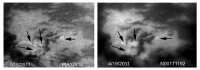
QUOTE (ngunn @ Apr 22 2011, 05:06 AM)  Exceptionally fine Titan images from this flyby... Very nice indeed and interesting to compare with those of January 2011. The Adiri bright spots are still visible (see figure below) supporting the view these are changes in surface albedo rather than fog or clouds near the ground.
While the SAR Topo maps show Adiri is relative high ground and the bright spots are associated with bright terrain in ISS images, they don't seem to precisely register with the linear bright ridges (presumably the highest ground) seen in the T8 SAR swath. (see below)
|
||
|
|
|
||
|
Apr 30 2011, 02:51 AM
Post
#8
|
||
|
Member Group: Members Posts: 699 Joined: 1-April 08 From: Minnesota ! Member No.: 4081 |
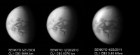
Latest Titan images (right image) continue to show the Senkyo region returning to its appearance before (left image) the T72 arrow storm. Middle image from Dec 20 2010 shows the storm's effect (arrow) with both darkening and brightening albedo differences.
|
|
|
|
|
|
|
Apr 30 2011, 07:37 PM
Post
#9
|
|
|
Senior Member Group: Moderator Posts: 2785 Joined: 10-November 06 From: Pasadena, CA Member No.: 1345 |
QUOTE (titanicrivers @ Apr 23 2011, 04:00 AM) While the SAR Topo maps show Adiri is relative high ground and the bright spots are associated with bright terrain in ISS images, they don't seem to precisely register with the linear bright ridges (presumably the highest ground) seen in the T8 SAR swath. The T8 Swath just "missed" the lower brighter area in the blink image. But assuming a regular mountain spacing, it's likely there is another mountain "line" just beyond the southern T8 edge that would correlate with the brightened area. The brightening effect doesn't necessarily need to correlate with elevation. Instead it might correlate with certain materials and the washing off of an overlaying "paint" on those materials. The assumption is that some materials might, but not always, correlate with elevation. (F'r instance, on Earth, granite might make up the tops of some mountains, while in others it might be schist. But in most cases the valley floors and lowlands are neither, being made up of clays, soils, and general alluvium.) Another possibility is that the stream bottoms have darker stuff in them. And the more dense the drainage network, the darker the overall terrain. So an elevated region without a lot of bigger channels (or higher order) might be able to brighten as dark stuff gets washed into channel bottoms. But lower down, where there are more channels (and channel bottoms) you still see the same amount of darker stuff so the brightening effect isn't so evident. In that case the brightening effect would correlate with drainage density (at a given channel size resolution), which may also correlate with material. (F'r instance, on Earth you get a much more impressive drainage density in soft clays and weak sandstone than you do in hard relatively impermeable granite or in strongly absorbing surfaces) -------------------- Some higher resolution images available at my photostream: http://www.flickr.com/photos/31678681@N07/
|
|
|
|
|
Apr 30 2011, 10:18 PM
Post
#10
|
|
|
Senior Member Group: Members Posts: 3516 Joined: 4-November 05 From: North Wales Member No.: 542 |
Good post Mike. Titan would have to be a very simple place if it could be understood entirely by analysing high/low and dark/bright. We are lucky to live on a world that is as complex as Titan, or more so. It may be a little simpler than Earth, but we should be ready for anything.
|
|
|
|
|
May 7 2011, 09:41 AM
Post
#11
|
|||
|
Member Group: Members Posts: 699 Joined: 1-April 08 From: Minnesota ! Member No.: 4081 |
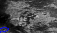
Excellent points Mike and Nigel ! Gets one thinking of what other correlations may exit. Interesting how Adiri was next in the path of the Arrow storm that inundated (blue outline) southern Belet (shown below, left image). The equatorial cloud pattern on images taken October 18th suggests storm continued its eastern march into Adiri encountering an upslope gradient. SAR topo measurements suggest a gain of 700 meters and Adiri bright spots tend to appear on the up-sloping terrain of the ridges. Using some of the cool maps in the text book "Titan from Cassini-Huygens" in the appendix there appears to be less correlation of the bright spots with RADAR backscatter values (surface roughness or reflective surfaces), surface brightness temperature (microwave thermal emissivity) or VIMS spectral units (the last shown in the figure below). With differing resolutions of these maps however the validity of the correlations is debatable.
EDIT: Sorry, but I just realized the Huygen's landing site was on the map and just had to put it in there (red + sign on the right).
I do believe Huygens may have gotten a good methane bath last September-October !! |
||
|
|
|
||
|
Dec 7 2011, 09:40 AM
Post
#12
|
||
|
Member Group: Members Posts: 699 Joined: 1-April 08 From: Minnesota ! Member No.: 4081 |
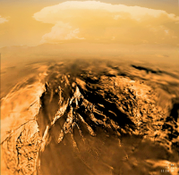
An imaginary scene from the Huygens landing site following passage of the 'Arrow Storm'. PIA08118 was blended with a New Mexico thunderhead near Granite Gap and colorized in Photoshop.
|
|
|
|
|
|
|
Dec 7 2011, 02:54 PM
Post
#13
|
|
|
Senior Member Group: Moderator Posts: 2785 Joined: 10-November 06 From: Pasadena, CA Member No.: 1345 |
Nice!
-------------------- Some higher resolution images available at my photostream: http://www.flickr.com/photos/31678681@N07/
|
|
|
|
|
Jan 24 2012, 09:04 AM
Post
#14
|
||
|
Member Group: Members Posts: 699 Joined: 1-April 08 From: Minnesota ! Member No.: 4081 |
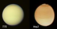
The T75 flyby produced Titan images that were one Saturn year (29.47 earth years) after the Voyager2 flyby in 1981. Although the filters and flyby orientation differs one can see similarity in Titan's appearance especially in the narrow dark northern band area.
|
|
|
|
|
|
|
Jan 24 2012, 09:27 AM
Post
#15
|
|
 Senior Member Group: Members Posts: 3648 Joined: 1-October 05 From: Croatia Member No.: 523 |
Not only the filters were different, but the processing was obviously different. High pass filtering, etc. If you applied the same processing to the Voyager images today, they would look pretty similar to Cassini images. Here's one such Voyager 2 shot.
-------------------- |
|
|
|
|

|
Lo-Fi Version | Time is now: 28th April 2024 - 02:49 AM |
|
RULES AND GUIDELINES Please read the Forum Rules and Guidelines before posting. IMAGE COPYRIGHT |
OPINIONS AND MODERATION Opinions expressed on UnmannedSpaceflight.com are those of the individual posters and do not necessarily reflect the opinions of UnmannedSpaceflight.com or The Planetary Society. The all-volunteer UnmannedSpaceflight.com moderation team is wholly independent of The Planetary Society. The Planetary Society has no influence over decisions made by the UnmannedSpaceflight.com moderators. |
SUPPORT THE FORUM Unmannedspaceflight.com is funded by the Planetary Society. Please consider supporting our work and many other projects by donating to the Society or becoming a member. |
|