The Valley Without Peril (Bay C5), after Cape of Good Hope |

  |
The Valley Without Peril (Bay C5), after Cape of Good Hope |
 Mar 11 2007, 08:32 AM Mar 11 2007, 08:32 AM
Post
#31
|
|
|
Senior Member  Group: Moderator Posts: 4279 Joined: 19-April 05 From: .br at .es Member No.: 253 |
RE steepness, I think BrianL is right.
The perception is usually worst from the top then from the side of a slope. |
 |
 
|
|
Mar 11 2007, 04:26 PM
Post
#32
|
||
 Senior Member Group: Members Posts: 4246 Joined: 17-January 05 Member No.: 152 |
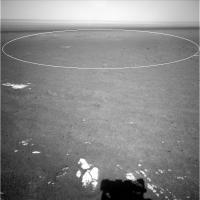
As you can see from Tesheiner's route map, we're pretty much sitting at the edge of the first of the darkest streaks that radiate out onto the plains. It's not as obvious when we're this close - I've circled it in this sol 1111 navcam:
|
|
|
|
|
|
|
Mar 12 2007, 05:13 PM
Post
#33
|
|
 Special Cookie Group: Members Posts: 2168 Joined: 6-April 05 From: Sintra | Portugal Member No.: 228 |
QUOTE (Stu @ Mar 11 2007, 08:31 AM)  Hey ustrax, how's this for an "abyss"...?  Yeap Stu...this is, in my oppinion, one of the most exciting views from this mission EVER! Beautiful and dramatic... 
-------------------- "Ride, boldly ride," The shade replied, "If you seek for Eldorado!"
Edgar Alan Poe |
|
|
|
|
Mar 12 2007, 06:12 PM
Post
#34
|
|
|
Member Group: Members Posts: 530 Joined: 21-March 06 From: Canada Member No.: 721 |
QUOTE (ustrax @ Mar 12 2007, 11:13 AM) in my oppinion, one of the most exciting views from this mission EVER! Beautiful and dramatic... Yep, indeed. Can we get a few of Fred's silhouettes in the shot for a sense of scale? Thanks Brian |
|
|
|
|
Mar 13 2007, 01:58 AM
Post
#35
|
|
|
Member Group: Members Posts: 599 Joined: 26-August 05 Member No.: 476 |
Valley Without Peril gets title billing in latest Opportunity update --
http://marsrover.nasa.gov/mission/status.html#opportunity |
|
|
|
|
Mar 13 2007, 03:11 AM
Post
#36
|
|
|
Solar System Cartographer Group: Members Posts: 10145 Joined: 5-April 05 From: Canada Member No.: 227 |
To me, the Valley without Peril looks very perilous - anyone can get into a hole, but I don't see Oppo getting out again, and the exposures don't look as accessible either. I say go back to Duck Bay.
Phil -------------------- ... because the Solar System ain't gonna map itself.
Also to be found posting similar content on https://mastodon.social/@PhilStooke NOTE: everything created by me which I post on UMSF is considered to be in the public domain (NOT CC, public domain) |
|
|
|
|
Mar 13 2007, 03:29 AM
Post
#37
|
|
|
Junior Member Group: Members Posts: 52 Joined: 24-May 06 Member No.: 784 |
I too believe this this bay is probably not the safest ingress (I'm a big fan of looking at the bays closer to the Soup Dragon) but since I also hold a lot of trust for Oppy's drivers and mgmt, I'll just sit here and prepare for the rollercoaster ride down.
|
|
|
|
|
Mar 13 2007, 04:12 AM
Post
#38
|
|
|
Member Group: Members Posts: 258 Joined: 22-December 06 Member No.: 1503 |
I think the name is just a marker. It doesn't mean the MER team will take the rover down this bay. Duck bay might be better than this for safety reason.
Perhaps they see those magnificent cliffs as the target. If they can get there, it would be worth it. But I don't think they can safely get there. If they do try to go in here, the rover is not likely to get out--at least not the same way it went down. I see only one possible track down this particular bay. That track looks to be like a "dead man's curve" of a slope (from the recent pancamss of it). From above, it doesn't look so steep; but it is. |
|
|
|
|
Mar 13 2007, 07:23 AM
Post
#39
|
|
 The Insider Group: Members Posts: 669 Joined: 3-May 04 Member No.: 73 |
I think the steepness is an illusion from the pancam due to foreshortening. Navcam view looks much better, and once we get closer to the rim to see the full slope it should be manageable.
|
|
|
|
|
Mar 13 2007, 08:36 AM
Post
#40
|
|
|
Founder Group: Chairman Posts: 14431 Joined: 8-February 04 Member No.: 1 |
The new anims of Victoria crater made from HiRISE DEMS makes Sans-Peril look very interesting - especially when you don't have the really steep, large outcrops each side to hide the sun, and MODY.
Doug |
|
|
|
|
Mar 13 2007, 03:49 PM
Post
#41
|
|
|
Senior Member Group: Moderator Posts: 4279 Joined: 19-April 05 From: .br at .es Member No.: 253 |
QUOTE (mchan @ Mar 13 2007, 02:58 AM) Valley Without Peril gets title billing in latest Opportunity update -- http://marsrover.nasa.gov/mission/status.html#opportunity It includes the name of the next Cape, too. QUOTE Next week Opportunity will conduct an extensive long baseline stereo survey of the Valley Without Peril and "Cape St. Vincent." Does it sounds familiar to you, Ustrax? |
|
|
|
|
Mar 13 2007, 04:17 PM
Post
#42
|
|
|
Special Cookie Group: Members Posts: 2168 Joined: 6-April 05 From: Sintra | Portugal Member No.: 228 |
QUOTE (Tesheiner @ Mar 13 2007, 03:49 PM) It includes the name of the next Cape, too. Does it sounds familiar to you, Ustrax? ...Here it is... But it could also be this one... 
-------------------- "Ride, boldly ride," The shade replied, "If you seek for Eldorado!"
Edgar Alan Poe |
|
|
|
|
Mar 13 2007, 04:17 PM
Post
#43
|
|
|
The Insider Group: Members Posts: 669 Joined: 3-May 04 Member No.: 73 |
QUOTE (Tesheiner @ Mar 13 2007, 08:49 AM) It includes the name of the next Cape, too. http://www.unmannedspaceflight.com/index.p...ost&p=85647 
|
|
|
|
|
Mar 13 2007, 04:22 PM
Post
#44
|
|
|
The Insider Group: Members Posts: 669 Joined: 3-May 04 Member No.: 73 |
QUOTE (ustrax @ Mar 13 2007, 09:17 AM) But it could also be this one... Wow, the similarity is striking!  
|
|
|
|
|
Mar 13 2007, 05:52 PM
Post
#45
|
|
|
Special Cookie Group: Members Posts: 2168 Joined: 6-April 05 From: Sintra | Portugal Member No.: 228 |
QUOTE (Pando @ Mar 13 2007, 04:22 PM) Wow, the similarity is striking! Yes it is... That's quite a special place... Here you have some more images and information. But I believe that the Martian Cape was named after the South American one...
-------------------- "Ride, boldly ride," The shade replied, "If you seek for Eldorado!"
Edgar Alan Poe |
|
|
|
|

|
Lo-Fi Version | Time is now: 18th April 2024 - 05:30 AM |
|
RULES AND GUIDELINES Please read the Forum Rules and Guidelines before posting. IMAGE COPYRIGHT |
OPINIONS AND MODERATION Opinions expressed on UnmannedSpaceflight.com are those of the individual posters and do not necessarily reflect the opinions of UnmannedSpaceflight.com or The Planetary Society. The all-volunteer UnmannedSpaceflight.com moderation team is wholly independent of The Planetary Society. The Planetary Society has no influence over decisions made by the UnmannedSpaceflight.com moderators. |
SUPPORT THE FORUM Unmannedspaceflight.com is funded by the Planetary Society. Please consider supporting our work and many other projects by donating to the Society or becoming a member. |
|