Updated Titan Map |

  |
Updated Titan Map |
 Jun 25 2007, 06:01 PM Jun 25 2007, 06:01 PM
Post
#106
|
|
 Member  Group: Members Posts: 809 Joined: 11-March 04 Member No.: 56 |
QUOTE (tty @ Jun 25 2007, 02:56 PM)  The word you are looking for is "playa" tty Playas are typically a bit drier than what I was imagining. The "desert" regions might equally be characterized as playa. |
 |
 
|
|
Jun 25 2007, 07:26 PM
Post
#107
|
|
|
Senior Member Group: Members Posts: 3516 Joined: 4-November 05 From: North Wales Member No.: 542 |
mudflats?
|
|
|
|
|
Jun 25 2007, 07:53 PM
Post
#108
|
|
 Senior Member Group: Moderator Posts: 2785 Joined: 10-November 06 From: Pasadena, CA Member No.: 1345 |
How about a "goo-flat"?
Methane rain bring down organic shizzle where it accumulates into masses/drifts/globs on the surface. Without a major flooding event it will sit and get coated in "bright material" or other atmospheric coatings. Picture an on Earth full of shallow water like a flooded bayou. Then frogs lay oodles and oodles of humungous egg masses all over the place. As the water evaporates (or drains away) the gelatinous gooey egg masses are revealed on the surface. Imagine walking around with jiggling, gross, yukky masses forming a rough terrain as far as the eye can see. I imagine the Titanian "goo-flat" would look like that. (Slightly RADAR rough, ISS/VIMS would look like brighter material - definitely not dark blue ice sands nor dark brown dune sands) [[Not a place for a romantic holiday]]. -Mike P.S. Does anyone know what Death Valley (Badwater with the salt crystals) would look like by SAR? Would it appear roughish? -------------------- Some higher resolution images available at my photostream: http://www.flickr.com/photos/31678681@N07/
|
|
|
|
|
Jun 25 2007, 08:30 PM
Post
#109
|
|
 Senior Member Group: Members Posts: 2530 Joined: 20-April 05 Member No.: 321 |
QUOTE (Juramike @ Jun 25 2007, 12:53 PM) P.S. Does anyone know what Death Valley (Badwater with the salt crystals) would look like by SAR? Would it appear roughish? Funnily enough, Death Valley is shown on the Wikipedia page for SAR. http://upload.wikimedia.org/wikipedia/en/2...-valley-sar.jpg Looks somewhat Huygens-like to me! |
|
|
|
|
Jun 25 2007, 09:14 PM
Post
#110
|
|
|
Senior Member Group: Moderator Posts: 2785 Joined: 10-November 06 From: Pasadena, CA Member No.: 1345 |
Amazing! It does look pretty similar!
It took a few twists and turns with Google Earth to realize that this is of the northern (dune) part of Death Valley. Unfortunately, Badwater is just to the SSW from the lowest part of the image. I was wondering if the knobby little salt incrustations ('bout 10-20 inches across if I remember correct) of Devil's Golfcourse (near Badwater) would show up and similar to Cassini SAR of the Temperate zones. So close.... -Mike -------------------- Some higher resolution images available at my photostream: http://www.flickr.com/photos/31678681@N07/
|
|
|
|
|
Jun 26 2007, 02:39 PM
Post
#111
|
|
 Member Group: Members Posts: 610 Joined: 23-February 07 From: Occasionally in Columbia, MD Member No.: 1764 |
QUOTE (Juramike @ Jun 25 2007, 03:53 PM) P.S. Does anyone know what Death Valley (Badwater with the salt crystals) would look like by SAR? Would it appear roughish? Highly variable, as it turns out (as the image posted shows). Some of the very saline salt flats at Death Valley buckle on scales larger than the radar wavelength and thus are very rough and hence bright ; ditto the very rubbly Devils's Golfcourse or whatever it is called. Then you have really flat things like Racetrack playa which acts like a mirror (even more so when wet) and thus appears radar dark... |
|
|
|
|
Jun 26 2007, 08:23 PM
Post
#112
|
|
 Senior Member Group: Members Posts: 1628 Joined: 5-March 05 From: Boulder, CO Member No.: 184 |
Greetings,
Thought I'd mention a slight cleanup on the Titan map that I've now posted at this URL: http://laps.noaa.gov/albers/sos/sos.html#TITAN One can keep fiddling with this thing for quite a while... -------------------- Steve [ my home page and planetary maps page ]
|
|
|
|
|
Jun 26 2007, 08:47 PM
Post
#113
|
|
 Member Group: Members Posts: 146 Joined: 23-August 06 From: Vriezenveen, Netherlands Member No.: 1067 |
Steve, isn't your map aligned in a different way other maps have been submitted? I can't overlay your map onto previous maps.
|
|
|
|
|
Jun 26 2007, 09:08 PM
Post
#114
|
|
|
Senior Member Group: Members Posts: 1628 Joined: 5-March 05 From: Boulder, CO Member No.: 184 |
Cap-Team - this is hard for me to say. This should be the same as my previous iteration. It is centered on 180 degrees longitude and is a cylindrical equidistant projection if that helps you to overlay it.
-------------------- Steve [ my home page and planetary maps page ]
|
|
|
|
|
Oct 11 2007, 05:00 PM
Post
#115
|
||
|
Senior Member Group: Moderator Posts: 2785 Joined: 10-November 06 From: Pasadena, CA Member No.: 1345 |
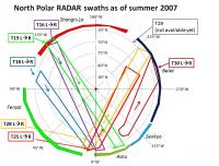
I created a graphic showing currently available north polar RADAR swaths that dip partially into the Equatorial Sand Sea.
This is adapted from the graphic in Mitchell et al IOF 2007 Abstract 6042 "Titan's North Polar Lakes as Observed by Cassini RADAR: An Update." (Abstract  ) )I've been using this to help make RADAR composites of Equatorial Sand Sea Basins:
-Mike -------------------- Some higher resolution images available at my photostream: http://www.flickr.com/photos/31678681@N07/
|
|
|
|
|
|
|
Oct 16 2007, 03:15 AM
Post
#116
|
||
|
Senior Member Group: Moderator Posts: 2785 Joined: 10-November 06 From: Pasadena, CA Member No.: 1345 |
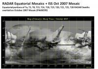
The Planetary Photojournal has release a new ISS Mosaic of Titan today! PIA08399.
Available at: http://photojournal.jpl.nasa.gov/catalog/PIA08399 I have taken all the Equatorial RADAR swath sections and overlaid them onto this new Mosaic:
Enjoy! -Mike -------------------- Some higher resolution images available at my photostream: http://www.flickr.com/photos/31678681@N07/
|
|
|
|
|
|
|
Oct 16 2007, 12:54 PM
Post
#117
|
|
|
Member Group: Members Posts: 813 Joined: 29-December 05 From: NE Oh, USA Member No.: 627 |
Nice map. Mike.... thanks.
And we have your plots on the south polar projection.... http://www.unmannedspaceflight.com/index.p...st&p=102003 Will be very interesting to see what ALL the instruments reveal there. Been reviewing the literature on clouds and hydrocarbon lakes and Titan climate models. What CHANGES will we see in the future....will comment later. A world-view is slowly beginning to develop. Craig |
|
|
|
|
Oct 16 2007, 01:11 PM
Post
#118
|
|
|
Solar System Cartographer Group: Members Posts: 10151 Joined: 5-April 05 From: Canada Member No.: 227 |
Juramike - post 115: go through LPI instead:
http://www.lpi.usra.edu/meetings/icysat2007/pdf/6042.pdf Phil -------------------- ... because the Solar System ain't gonna map itself.
Also to be found posting similar content on https://mastodon.social/@PhilStooke Maps for download (free PD: https://upload.wikimedia.org/wikipedia/comm...Cartography.pdf NOTE: everything created by me which I post on UMSF is considered to be in the public domain (NOT CC, public domain) |
|
|
|
|
Oct 16 2007, 01:49 PM
Post
#119
|
|||
|
Solar System Cartographer Group: Members Posts: 10151 Joined: 5-April 05 From: Canada Member No.: 227 |
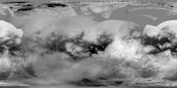
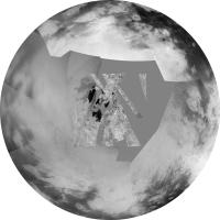
This is the new radar map of the north pole added to the new ISS map:
and here's the northern hemisphere from that map in polar (equidistant azimuthal) projection.
Phil -------------------- ... because the Solar System ain't gonna map itself.
Also to be found posting similar content on https://mastodon.social/@PhilStooke Maps for download (free PD: https://upload.wikimedia.org/wikipedia/comm...Cartography.pdf NOTE: everything created by me which I post on UMSF is considered to be in the public domain (NOT CC, public domain) |
||
|
|
|
||
|
Oct 16 2007, 01:54 PM
Post
#120
|
|
 Senior Member Group: Members Posts: 3648 Joined: 1-October 05 From: Croatia Member No.: 523 |
Great stuff, Phil!
I don't suppose there's a slightly less compressed version of the cylindrical map to be had? -------------------- |
|
|
|
|

|
Lo-Fi Version | Time is now: 25th April 2024 - 09:38 PM |
|
RULES AND GUIDELINES Please read the Forum Rules and Guidelines before posting. IMAGE COPYRIGHT |
OPINIONS AND MODERATION Opinions expressed on UnmannedSpaceflight.com are those of the individual posters and do not necessarily reflect the opinions of UnmannedSpaceflight.com or The Planetary Society. The all-volunteer UnmannedSpaceflight.com moderation team is wholly independent of The Planetary Society. The Planetary Society has no influence over decisions made by the UnmannedSpaceflight.com moderators. |
SUPPORT THE FORUM Unmannedspaceflight.com is funded by the Planetary Society. Please consider supporting our work and many other projects by donating to the Society or becoming a member. |
|