Printable Version of Topic
Click here to view this topic in its original format
Unmanned Spaceflight.com _ Earth Observations _ European Remote Sensing Satellites
Posted by: ljk4-1 Feb 14 2006, 03:37 PM
Double views from ERS tandem mission adding depth to Canadian wilderness maps
Unique views of Earth afforded by a pioneering twin ESA radar satellite flight
has brought an extra dimension to maps of Canada's newest territory, the results
winning praise from the Canadian government.
Full story at:
http://www.esa.int/esaEO/SEMDKSLVGJE_economy_0.html
Posted by: ljk4-1 Feb 24 2006, 10:26 PM
This Envisat image is focused over the Patagonia Plateau in Argentina and
southern Chile, and shows the snow-capped Andes mountain range which forms a
natural boundary between the two countries.
More at:
http://www.esa.int/esaEO/SEML8FMVGJE_index_0.html
Posted by: ljk4-1 Mar 10 2006, 12:11 PM
Satellite images acquired by ESAs ERS-2 revealed the recently discovered
changes in Yellowstones caldera are the result of molten rock movement 15
kilometres below Earths surface, according to a recent study published in
Nature.
Full story:
http://www.esa.int/esaEO/SEM9YBNVGJE_index_0.html
Posted by: ljk4-1 May 23 2006, 04:46 PM
Check out this artist's impression of the Earth Gravity field and Ocean Circulation
(GOCE) satellite to be launched by ESA in 2007:
http://www.esa.int/esaEO/SEMHQH9ATME_index_1.html#subhead2
It looks like the lead ship of the Zorgon invasion fleet!
From this article:
Six new Earth Explorer missions selected for further study
23 May 2006
ESA has announced the shortlist of new Earth Explorer mission proposals within its Living Planet Programme. This is part of the selection procedure that will eventually lead to the launch of the fourth Earth Explorer Core mission during the first half of the next decade.
http://www.esa.int/esaEO/SEMHQH9ATME_index_0.html
Posted by: imipak Oct 24 2008, 02:26 PM
The BBC reports that http://news.bbc.co.uk/go/rss/-/1/hi/sci/tech/7592689.stm, due to issues with the launch vehicle.
Posted by: PDP8E Apr 29 2012, 07:09 PM
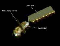
Envisat has been abruptly silent for a few weeks now...
France's Pleiades imaging satellite took this optical photo of Envisat on April 15 at a range of about 100 kilometers, or approximately 62 miles. Credit: CNES
|
http://www.spaceflightnow.com/news/n1204/21envisat/
Powered by Invision Power Board (http://www.invisionboard.com)
© Invision Power Services (http://www.invisionpower.com)