T28 (April 10th 2007) |

  |
T28 (April 10th 2007) |
 Jul 23 2007, 07:00 PM Jul 23 2007, 07:00 PM
Post
#46
|
||||
 Senior Member  Group: Moderator Posts: 2785 Joined: 10-November 06 From: Pasadena, CA Member No.: 1345 |
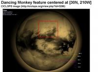
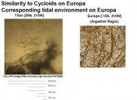
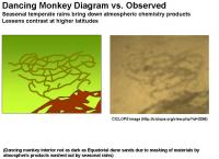
The Dancing Monkey feature located in the bright temperate highland area N of Adiri (approx location [30N, 210W]) looks very much like a cycloid crack pattern as seen on Europa.
Here are is an image of the Dancing Monkey feature (clipped from the CICLOPS website in the Looking Ahead Rev 47 post). And here is an image of a similarly complex patterned area on Europa.
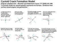
It is thought that the cycloids are generated by diurnal tides. (Europa orbits Jupiter every 3.55 days). Each arc is generated in one orbit due to changing and rotating tidal forces. The area on Titan and the area imaged on Europa are in almost the same tidal force environments (same longitude, almost exact opposite latitude). [Fun fact: (0N,0W) is the subprimary point for rotationally locked moons.] See this post for diagram showing Titans tidal forces and this post showing where the forces in Titan are strongest. Cycloid cracks are now thought to result from rotating tensile and shear stresses (Marshall and Kattenhorn Icarus 177 (2005) 341-366. A revised model for cycloid growth mechanics on Europa: Evidence from surface morphologies and geometries HTML (text-only no pictures - freely available here (A earlier work describing strike-slip faults on Europa is available freely here). A diagram of the cycloid growth model proposed by Marshall and Kattenhorn is shown below:
At a certain point, the tensile strength of the crust (ice) breaks and a crack forms and propagates. If the forces rotate faster than the crack propogates, the crack will try to form an arc. But as the forces rotate faster, they set up a shear as the tidal pull yanks the material on one side of the crack. The crack then begins to behave as a slip fault. Eventually the tensile force decreases, the crack stops propogating. But the forces keep rotating and eventually set up a shear in the old crack, and a tensile stress in the terminus. The shear forms a tailcrack and the crack propogates again. This makes a line with a series of arcs hopping across the surface. From the article, I got the impression that faults and cycloid cracks on Europa might be two flavors of the same thing. Also, cycloid cracks have recently been observed on Enceladuss south pole: Hurford et al. LPS XXXVIII (2007) Abstract 1844. A cycloid-like rift near Enceladus South Pole: Europa-style Production by Tidal Stress.. Abstract freely available here. -Mike -------------------- Some higher resolution images available at my photostream: http://www.flickr.com/photos/31678681@N07/
|
|||
 |
 
|
|||
|
Jul 23 2007, 07:27 PM
Post
#47
|
||||||||||||
|
Senior Member Group: Moderator Posts: 2785 Joined: 10-November 06 From: Pasadena, CA Member No.: 1345 |
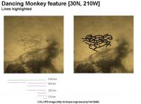
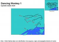
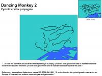
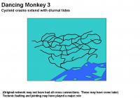
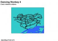
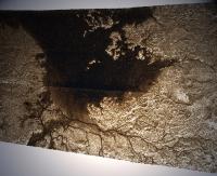
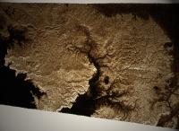
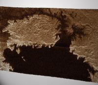
Europa-like cycloid crack propagation may be responsible for the evolution of the Dancing Monkey feature as shown in the following putative formation sequence. This final steps of this sequence are pretty much the same as proposed for the putative formation sequence for the neighboring Sliced Carrot feature (described in this post), save for the atmospheric chemistry product deposition:
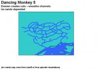
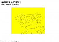
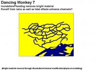
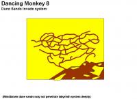
Here are the steps in the putative sequence: 1) Cycloid cracks start 2) Cycloid cracks propagate (1 arc/orbit) 3) Cycloid cracks continue (Tectonic faulting also?) 4) Network widens 5) Erosion from runoff cuts/shapes makes new channels (river capture?): dark blue ice sands deposited 6) Bright material deposited 7) Inundation and flooding by hydrocarbon solvents removes bright material from below flood stage 8) Dune sands invade system 9) Atmospheric chemistry products brought down by seasonal rains: deposition over dune sands and bright highlands: contrast lowered. (The exact formation sequence of the network will be very tricky to work out. Different cracks may have formed at different times. Shifting and faulting may also have occurred to complicate matters). Here is a comparsion of the diagram from the sequence above with the observed image:
The Dancing Monkey feature is probably an overall shallow area that has cracks just at the right level to be inundated by flood events that removed the bright material and increased contrast. Rather than a series of canyons and hoodoos, the feature most likely resembles a low-lying series of backwater sloughs. (using the western US definition of slough. Earth analog: Elkhorn Slough wiki here: http://en.wikipedia.org/wiki/Elkhorn_Slough) We may expect to see more regions of cycloid cracks on Titan. The area directly to the SE of the Dancing Monkey feature may have formed similarly but lying slightly lower, was subject to more extensive erosion from fluvial and tidal effects of the Equatorial Sand sea basins. It might be interesting to see if any of the ridges or grabens have a cycloidal or arcuate pattern overprinted on them. (T8 RADAR swath ridges that look like ski tracks? Or the "tiger stripes" river paths waaay up north?) -Mike -------------------- Some higher resolution images available at my photostream: http://www.flickr.com/photos/31678681@N07/
|
|||||||||||
|
|
|
|||||||||||
|
Jul 24 2007, 06:59 AM
Post
#48
|
|
|
Senior Member Group: Members Posts: 1870 Joined: 20-February 05 Member No.: 174 |
Why do I keep thinking it looks like the Flying Spaghetti Monster....?
|
|
|
|
|
Jul 27 2007, 01:42 AM
Post
#49
|
|
|
Solar System Cartographer Group: Members Posts: 10151 Joined: 5-April 05 From: Canada Member No.: 227 |
That was my thought too. Anyone for pasta?
Phil -------------------- ... because the Solar System ain't gonna map itself.
Also to be found posting similar content on https://mastodon.social/@PhilStooke Maps for download (free PD: https://upload.wikimedia.org/wikipedia/comm...Cartography.pdf NOTE: everything created by me which I post on UMSF is considered to be in the public domain (NOT CC, public domain) |
|
|
|
|
Jul 27 2007, 07:48 AM
Post
#50
|
|
|
Senior Member Group: Members Posts: 1870 Joined: 20-February 05 Member No.: 174 |
It's only a fake flying spaghetti monster....
....so it's an im-pasta! |
|
|
|
|
Jul 27 2007, 01:33 PM
Post
#51
|
|
 Senior Member Group: Members Posts: 3648 Joined: 1-October 05 From: Croatia Member No.: 523 |
Apologies if this was already mentioned somewhere, but the full T28 RADAR swath was released today:
PIA09217 -------------------- |
|
|
|
|
Jul 27 2007, 01:49 PM
Post
#52
|
|
|
Senior Member Group: Members Posts: 3516 Joined: 4-November 05 From: North Wales Member No.: 542 |
Thanks ugordan - it's a beauty.
|
|
|
|
|
Jul 27 2007, 02:15 PM
Post
#53
|
|
|
Member Group: Members Posts: 813 Joined: 29-December 05 From: NE Oh, USA Member No.: 627 |
I was just going to post this.....
thanks uugordon. Hopefully this is a harbinger of more releases to come?!?!. Craig |
|
|
|
|
Jul 27 2007, 03:33 PM
Post
#54
|
|
|
Senior Member Group: Moderator Posts: 2785 Joined: 10-November 06 From: Pasadena, CA Member No.: 1345 |
Awesome!
Wher is this located on Titan? Anybody got an global map with the T28 RADAR swath indicated? -Mike -------------------- Some higher resolution images available at my photostream: http://www.flickr.com/photos/31678681@N07/
|
|
|
|
|
Jul 27 2007, 03:46 PM
Post
#55
|
|
|
Member Group: Members Posts: 813 Joined: 29-December 05 From: NE Oh, USA Member No.: 627 |
Mike..
looks like this starts in Tsegihi and crosses Aztlan and Fensel as it heads north east. See slides 14 and 16 in this last CHARM presentation http://saturn.jpl.nasa.gov/multimedia/prod...CHARM_3Year.pdf Anybody have radar swath maps that are labeled? Craig |
|
|
|
|
Jul 27 2007, 05:40 PM
Post
#56
|
|
 Member Group: Members Posts: 610 Joined: 23-February 07 From: Occasionally in Columbia, MD Member No.: 1764 |
QUOTE (belleraphon1 @ Jul 27 2007, 10:15 AM)  Hopefully this is a harbinger of more releases to come?!?!. Yes. |
|
|
|
|
Jul 27 2007, 07:43 PM
Post
#57
|
|
|
Member Group: Members Posts: 813 Joined: 29-December 05 From: NE Oh, USA Member No.: 627 |
QUOTE (rlorenz @ Jul 27 2007, 01:40 PM) Yes. More Please!!!!!!!!!! 
|
|
|
|
|
Jul 27 2007, 09:32 PM
Post
#58
|
||||
 The Poet Dude Group: Moderator Posts: 5551 Joined: 15-March 04 From: Kendal, Cumbria, UK Member No.: 60 |
QUOTE (ugordan @ Jul 27 2007, 02:33 PM) the full T28 RADAR swath was released today: Some highlights of the lakes area... as usual, purely for "wow" reasons, not suggesting any scientific worth, ok?

-------------------- |
|||
|
|
|
|||
|
Jul 27 2007, 09:48 PM
Post
#59
|
|
|
Member Group: Members Posts: 813 Joined: 29-December 05 From: NE Oh, USA Member No.: 627 |
Calling all image mages.... ALERT ALERT ALERT.....
Can some one line up http://photojournal.jpl.nasa.gov/catalog/PIA09217 from T28 with http://photojournal.jpl.nasa.gov/catalog/PIA09182 from T25? And very evocative images Stu.... Amazing little world.... I am constantly amazed seeing these swaths.... as lively a place as we could wish for....... I was commenting to a coworker how wonderful these data are and I still have to pinch myself to be sure this is not some science fiction dream. This is for real.... Craig |
|
|
|
|
Jul 27 2007, 10:05 PM
Post
#60
|
|
|
Senior Member Group: Moderator Posts: 2785 Joined: 10-November 06 From: Pasadena, CA Member No.: 1345 |
Hey Craig,
I think I got the lower part (I stuck it in the Equatorial Sand Seas thread) here: (T25 was in the Exploitcorporations mosaic, you may may need to enlarge it to see the T25 insertion. It is immediately to the W of the T28 swath, and also has Sotra Facula at its lower section) -Mike -------------------- Some higher resolution images available at my photostream: http://www.flickr.com/photos/31678681@N07/
|
|
|
|
|

|
Lo-Fi Version | Time is now: 25th April 2024 - 04:05 AM |
|
RULES AND GUIDELINES Please read the Forum Rules and Guidelines before posting. IMAGE COPYRIGHT |
OPINIONS AND MODERATION Opinions expressed on UnmannedSpaceflight.com are those of the individual posters and do not necessarily reflect the opinions of UnmannedSpaceflight.com or The Planetary Society. The all-volunteer UnmannedSpaceflight.com moderation team is wholly independent of The Planetary Society. The Planetary Society has no influence over decisions made by the UnmannedSpaceflight.com moderators. |
SUPPORT THE FORUM Unmannedspaceflight.com is funded by the Planetary Society. Please consider supporting our work and many other projects by donating to the Society or becoming a member. |
|