HAMO, (aka High Altitude Mapping Orbit) |

  |
HAMO, (aka High Altitude Mapping Orbit) |
 Sep 1 2011, 01:12 PM Sep 1 2011, 01:12 PM
Post
#1
|
|
|
Solar System Cartographer  Group: Members Posts: 10229 Joined: 5-April 05 From: Canada Member No.: 227 |
According to Dawn (who ought to know) the descent to the next mapping orbit is beginning now.
"NASA_Dawn NASA's Dawn Mission I'm done with Survey science operations today!! Time for a several-week transfer down to High Altitude Mapping Orbit (HAMO)!! 20 hours ago" Better pics on the way! Thanks, Dawn team, for the pictures so far. Will we learn of any preliminary nomenclature soon? Phil -------------------- ... because the Solar System ain't gonna map itself.
Also to be found posting similar content on https://mastodon.social/@PhilStooke Maps for download (free PDF: https://upload.wikimedia.org/wikipedia/comm...Cartography.pdf NOTE: everything created by me which I post on UMSF is considered to be in the public domain (NOT CC, public domain) |
 |
 
|
|
Sep 1 2011, 08:17 PM
Post
#2
|
|
|
Member Group: Members Posts: 599 Joined: 26-August 05 Member No.: 476 |
Marc Rayman's latest Dawn Journal on HAMO --
"...they have been able to detect variations in the gravity field that are due to the uneven distribution of mass within the protoplanet. With their improved charts of the waters around Vesta, they plotted the ships course, and it is now under sail. Thrusting with the ion propulsion system began on August 31 at 4:05 p.m. PDT, and this trip to the high altitude mapping orbit will take a month." |
|
|
|
|
Sep 2 2011, 05:55 PM
Post
#3
|
|
 Member Group: Members Posts: 207 Joined: 6-March 07 From: houston, texas Member No.: 1828 |
QUOTE (Phil Stooke @ Sep 1 2011, 07:12 AM)  According to Dawn (who ought to know) the descent to the next mapping orbit is beginning now. "NASA_Dawn NASA's Dawn Mission I'm done with Survey science operations today!! Time for a several-week transfer down to High Altitude Mapping Orbit (HAMO)!! 20 hours ago" Better pics on the way! Thanks, Dawn team, for the pictures so far. Will we learn of any preliminary nomenclature soon? Phil Hi Phil! Nomenclature work has only just begun. we have been "surveying' the Survey data as it were, simply getting a feel for the geography. Once the coordinate system has been fixed, we will proceed with names. A list of names is ready to go, we just need to identify which features are priority for the first batch of names. cheers paul -------------------- Dr. Paul Schenk, Lunar and Planetary Institute, Houston TX
http://stereomoons.blogspot.com; http://www.youtube.com/galsat400; http://www.lpi.usra.edu/science/schenk/ |
|
|
|
|
Sep 2 2011, 06:00 PM
Post
#4
|
|
|
Solar System Cartographer Group: Members Posts: 10229 Joined: 5-April 05 From: Canada Member No.: 227 |
Thanks, Paul.
Phil -------------------- ... because the Solar System ain't gonna map itself.
Also to be found posting similar content on https://mastodon.social/@PhilStooke Maps for download (free PDF: https://upload.wikimedia.org/wikipedia/comm...Cartography.pdf NOTE: everything created by me which I post on UMSF is considered to be in the public domain (NOT CC, public domain) |
|
|
|
|
Sep 3 2011, 07:19 AM
Post
#5
|
||
 Senior Member Group: Members Posts: 2492 Joined: 15-January 05 From: center Italy Member No.: 150 |
Thanks for updates, Paul!
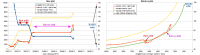
Here below the updated velocity/distance plots, current transfer orbit is clearly elliptical.
-------------------- I always think before posting! - Marco -
|
|
|
|
|
|
|
Sep 3 2011, 04:29 PM
Post
#6
|
||
|
Member Group: Members Posts: 207 Joined: 6-March 07 From: houston, texas Member No.: 1828 |
QUOTE (dilo @ Sep 3 2011, 01:19 AM) Thanks for updates, Paul! Here below the updated velocity/distance plots, current transfer orbit is clearly elliptical.
no problem. will try to be more informative as the mission goes on, but i get distracted easily . . . btw, where are u getting that plot from? I should be monitoring it i suppose! -------------------- Dr. Paul Schenk, Lunar and Planetary Institute, Houston TX
http://stereomoons.blogspot.com; http://www.youtube.com/galsat400; http://www.lpi.usra.edu/science/schenk/ |
|
|
|
|
|
|
Sep 3 2011, 05:42 PM
Post
#7
|
|
|
Senior Member Group: Members Posts: 2492 Joined: 15-January 05 From: center Italy Member No.: 150 |
I made by myself using MYSTIC simulator info from JPL Dawn site. Obviously, not real-time data nor continuous coverage, if you have something better, pls give us!
 -------------------- I always think before posting! - Marco -
|
|
|
|
|
Sep 3 2011, 08:58 PM
Post
#8
|
|
|
Junior Member Group: Members Posts: 22 Joined: 23-August 11 From: France Member No.: 6134 |
First Message: Hello everybody
 Answering dilo: You can use SPICE data from NAIF: ftp://naif.jpl.nasa.gov/pub/naif/DAWN/kernels/ For example, I product this http://www.youtube.com/watch?v=qWZbcAKXu-s from theses data. The problem is that you should have some (but little  ) programming skill for using SPICE files. ) programming skill for using SPICE files. But the good news is that the NAIF library (see upper node of link) is full of documentations and tools to learn and use it. But maybe DrShank know a better way ? |
|
|
|
|
Sep 4 2011, 11:36 PM
Post
#9
|
|
|
Member Group: Members Posts: 207 Joined: 6-March 07 From: houston, texas Member No.: 1828 |
QUOTE (Sarunia @ Sep 3 2011, 02:58 PM) First Message: Hello everybody Answering dilo: You can use SPICE data from NAIF: ftp://naif.jpl.nasa.gov/pub/naif/DAWN/kernels/ For example, I product this http://www.youtube.com/watch?v=qWZbcAKXu-s from theses data. The problem is that you should have some (but little ) programming skill for using SPICE files. But the good news is that the NAIF library (see upper node of link) is full of documentations and tools to learn and use it. But maybe DrShank know a better way ? not without doing some research into it . . . -------------------- Dr. Paul Schenk, Lunar and Planetary Institute, Houston TX
http://stereomoons.blogspot.com; http://www.youtube.com/galsat400; http://www.lpi.usra.edu/science/schenk/ |
|
|
|
|
Sep 5 2011, 11:10 AM
Post
#10
|
||
|
Senior Member Group: Members Posts: 2492 Joined: 15-January 05 From: center Italy Member No.: 150 |
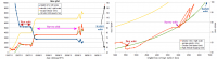
QUOTE (Sarunia @ Sep 3 2011, 08:58 PM) ... The problem is that you should have some (but little ) programming skill for using SPICE files. But the good news is that the NAIF library (see upper node of link) is full of documentations and tools to learn and use it. Thanks Sarunia, not an easy task for me (unless someone wants to help on this). For the moment, I'm still updating from simulator:
-------------------- I always think before posting! - Marco -
|
|
|
|
|
|
|
Sep 5 2011, 03:03 PM
Post
#11
|
||
|
Solar System Cartographer Group: Members Posts: 10229 Joined: 5-April 05 From: Canada Member No.: 227 |
Great pictures recently - not from HAMO yet or even the descent to HAMO, but really giving a taste of what the surface will look like in the weeks to come.
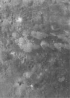
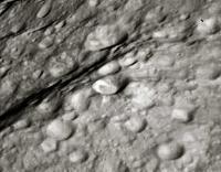
http://dawn.jpl.nasa.gov/multimedia/imageo...=2011-September I'm especially interested at the moment in this area from the Sept. 3 release:
Interesting bright patches on a darker surface. Phil -------------------- ... because the Solar System ain't gonna map itself.
Also to be found posting similar content on https://mastodon.social/@PhilStooke Maps for download (free PDF: https://upload.wikimedia.org/wikipedia/comm...Cartography.pdf NOTE: everything created by me which I post on UMSF is considered to be in the public domain (NOT CC, public domain) |
|
|
|
|
|
|
Sep 5 2011, 03:36 PM
Post
#12
|
|
 Member Group: Members Posts: 259 Joined: 23-January 05 From: Seattle, WA Member No.: 156 |
Dare I say those lobate margins look like flow features? Fun to think about, anyway!
|
|
|
|
|
Sep 6 2011, 10:22 AM
Post
#13
|
||
|
Senior Member Group: Members Posts: 3008 Joined: 30-October 04 Member No.: 105 |
> I'm especially interested at the moment in this area from the Sept. 3 release:
And why does this crater have an eccentric fill on the floor? What a peculiar little world.
Attached thumbnail(s)
-------------------- |
|
|
|
|
|
|
Sep 6 2011, 01:19 PM
Post
#14
|
|
|
Member Group: Members Posts: 207 Joined: 6-March 07 From: houston, texas Member No.: 1828 |
QUOTE (Bill Harris @ Sep 6 2011, 04:22 AM) What a peculiar little world. The Dawn team could not agree more! as far as those bright and dark splotches, we are scratching our heads too. they do not seem to have much relief at this resolution (we are still at ~250 meters and will move to HAMO resolution very slowly) but each significant increase in resolution has forced us to rethink some of our previous conclusions! Vesta is not a simple world. -------------------- Dr. Paul Schenk, Lunar and Planetary Institute, Houston TX
http://stereomoons.blogspot.com; http://www.youtube.com/galsat400; http://www.lpi.usra.edu/science/schenk/ |
|
|
|
|
Sep 6 2011, 01:49 PM
Post
#15
|
|
|
Solar System Cartographer Group: Members Posts: 10229 Joined: 5-April 05 From: Canada Member No.: 227 |
The eccentric fill may be a result of a local slope - the fill is horizontal, the crater's tilted. Of course, we need a proper shape model and interior mass distribution model to be sure, but that's my guess.
Phil -------------------- ... because the Solar System ain't gonna map itself.
Also to be found posting similar content on https://mastodon.social/@PhilStooke Maps for download (free PDF: https://upload.wikimedia.org/wikipedia/comm...Cartography.pdf NOTE: everything created by me which I post on UMSF is considered to be in the public domain (NOT CC, public domain) |
|
|
|
|

|
Lo-Fi Version | Time is now: 26th September 2024 - 10:08 AM |
|
RULES AND GUIDELINES Please read the Forum Rules and Guidelines before posting. IMAGE COPYRIGHT |
OPINIONS AND MODERATION Opinions expressed on UnmannedSpaceflight.com are those of the individual posters and do not necessarily reflect the opinions of UnmannedSpaceflight.com or The Planetary Society. The all-volunteer UnmannedSpaceflight.com moderation team is wholly independent of The Planetary Society. The Planetary Society has no influence over decisions made by the UnmannedSpaceflight.com moderators. |
SUPPORT THE FORUM Unmannedspaceflight.com is funded by the Planetary Society. Please consider supporting our work and many other projects by donating to the Society or becoming a member. |
|