From Cambridge Bay to the "parking lot" |

  |
From Cambridge Bay to the "parking lot" |
 Sep 3 2010, 06:22 PM Sep 3 2010, 06:22 PM
Post
#31
|
|
 Junior Member  Group: Members Posts: 39 Joined: 19-August 09 From: Dallas Member No.: 4905 |
Great Stu. Comparing the sizes gives you the sense of how thin is Mars' atmosphere to allow creation of group of such small craters.
I wonder if the fact that parent body of that crater group broke up/exploded before impact would mean there is gonna be (or was in the past) a large number of meteorites on the ground. |
 |
 
|
|
Sep 3 2010, 06:42 PM
Post
#32
|
|
|
Member Group: Members Posts: 252 Joined: 27-April 05 Member No.: 365 |
*glances at Scott's blog*
When was the last time Oppy drover over 100m? |
|
|
|
|
Sep 3 2010, 06:47 PM
Post
#33
|
||
|
Member Group: Members Posts: 194 Joined: 3-January 10 Member No.: 5156 |
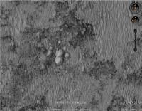
QUOTE (Stu @ Sep 3 2010, 07:41 PM)  ... and just to give a sense of scale, here's "Oppy" (scale correct, it's cloned from the same HiRISE image) next to the craters... Hey, it is just a marsian cat paw. It reminds me of the footsteps of a giant cat. So we could name them "cat paw crater"?
Attached thumbnail(s)
-------------------- Need more input ...
|
|
|
|
|
|
|
Sep 3 2010, 07:03 PM
Post
#34
|
|
 Senior Member Group: Members Posts: 1421 Joined: 26-July 08 Member No.: 4270 |
QUOTE (Burmese @ Sep 3 2010, 01:42 PM) When was the last time Oppy drover over 100m? I think the last time the rover drover over 100 m was on its way to Victoria. -------------------- -- Hungry4info (Sirius_Alpha)
|
|
|
|
|
Sep 3 2010, 07:27 PM
Post
#35
|
|
|
Member Group: Members Posts: 128 Joined: 28-October 08 From: Boston, MA Member No.: 4469 |
QUOTE (Hungry4info @ Sep 3 2010, 02:03 PM) I think the last time the rover drover over 100 m was on its way to Victoria. Actually, the last time she topped 100m was on sol 1954 while she was backtracking to Block Island. I have the very specific figure 107.48 recorded in my ongoing spreadsheet, but I don't know where that came from now. The official weekly update for that sol states simply that it was "over a 100 meter (328-foot) drive". She also drove 137 meters on sol 1864 while blazing past Porcupine. EDIT: Found it. The 107.48 came from A.J.S. Rayl's Planetary Society rover update for July 2009. |
|
|
|
|
Sep 3 2010, 07:35 PM
Post
#36
|
|
 Member Group: Members Posts: 656 Joined: 20-April 05 From: League City, Texas Member No.: 285 |
QUOTE (Stu @ Sep 3 2010, 11:41 AM) [attachment=22441:craters_plus_oppy.jpg] I think those are mounds. Compare the lighting with that on the dunes. Of course, how the mounds came to be is another matter. |
|
|
|
|
Sep 3 2010, 08:00 PM
Post
#37
|
|
|
Member Group: Members Posts: 530 Joined: 21-March 06 From: Canada Member No.: 721 |
If they were mounds, would they not be lit on the same side as the dunes?

|
|
|
|
|
Sep 3 2010, 08:09 PM
Post
#38
|
|
|
Solar System Cartographer Group: Members Posts: 10153 Joined: 5-April 05 From: Canada Member No.: 227 |
That's a very common optical illusion with planetary images. But no, they actually are craters!
Phil -------------------- ... because the Solar System ain't gonna map itself.
Also to be found posting similar content on https://mastodon.social/@PhilStooke Maps for download (free PD: https://upload.wikimedia.org/wikipedia/comm...Cartography.pdf NOTE: everything created by me which I post on UMSF is considered to be in the public domain (NOT CC, public domain) |
|
|
|
|
Sep 3 2010, 08:18 PM
Post
#39
|
|
 Senior Member Group: Admin Posts: 4763 Joined: 15-March 05 From: Glendale, AZ Member No.: 197 |
QUOTE (algorimancer @ Sep 3 2010, 11:35 AM) I think those are mounds. Save the image to your computer and then rotate it 90 and 180 degrees. Your mounds will become craters again. -------------------- If Occam had heard my theory, things would be very different now.
|
|
|
|
|
Sep 3 2010, 11:21 PM
Post
#40
|
|
|
Junior Member Group: Members Posts: 39 Joined: 19-August 09 From: Dallas Member No.: 4905 |
I actually tried to force my brain to see mounds and I couldn't, so the illusion works both ways.
My eyes hurt now... 
|
|
|
|
|
Sep 4 2010, 04:05 AM
Post
#41
|
||
 Senior Member Group: Members Posts: 2228 Joined: 1-December 04 From: Marble Falls, Texas, USA Member No.: 116 |
What do you mean they aren't mounds?

-------------------- ...Tom
I'm not a Space Fan, I'm a Space Exploration Enthusiast. |
|
|
|
|
|
| Guest_Bobby_* |
Sep 4 2010, 04:11 AM
Post
#42
|
|
Guests |
As we keep dropping in elevation. At our current position. Are we lower then the bottom of Victoria Crater yet and would any exposed bedrock we drive upon now be the layers that might be at the bottom of Victoria???
I would say our next stop for investigation will be the group of small craters we are heading for. |
|
|
|
|
Sep 4 2010, 05:44 AM
Post
#43
|
|
|
Senior Member Group: Members Posts: 2228 Joined: 1-December 04 From: Marble Falls, Texas, USA Member No.: 116 |
Bobby: As best as I can tell, the lowest point inside Victoria Crater is -1451 meters below the Mars datum. That's from the Google Mars model, which, as we have seen, has some problems with the real Mars. Opportunity's current location would appear to be somewhere around -1385 meters in the same model...quite a few meters above the lowest apparent point inside Victoria. Shortly after Oppy passes Santa Maria she'll be at an elevation near to the bottom of Victoria.
As for your bedrock layers question, that is more difficult to answer. It depends on whether those layers are perfectly flat, or if they are tilting in one direction or another. -------------------- ...Tom
I'm not a Space Fan, I'm a Space Exploration Enthusiast. |
|
|
|
|
Sep 4 2010, 07:41 AM
Post
#44
|
|
|
Senior Member Group: Members Posts: 3516 Joined: 4-November 05 From: North Wales Member No.: 542 |
QUOTE (CosmicRocker @ Sep 4 2010, 06:44 AM) Shortly after Oppy passes Santa Maria she'll be at an elevation near to the bottom of Victoria. I don't think that's right. This map shows a moderate slope of several hundred metres going down into the crater from the relatively level parking lot: http://www.unmannedspaceflight.com/index.p...st&id=20806 |
|
|
|
|
Sep 5 2010, 03:39 AM
Post
#45
|
|
|
Senior Member Group: Members Posts: 2228 Joined: 1-December 04 From: Marble Falls, Texas, USA Member No.: 116 |
Sorry, ngunn. I don't understand your point. According to the Victoria Crater DEM, the lowest point inside the crater is about -1450 meters. On the map you cite, the -1450 contour crosses the future route path about 1 kilometer SE of Santa Maria. At that point Opportunity will be at the same elevation as the bottom of Victoria Crater. If the bedrock layers are actually horizontal across this region, then Oppy may be driving on the same layers of rock as would be found at the bottom of Victoria.
-------------------- ...Tom
I'm not a Space Fan, I'm a Space Exploration Enthusiast. |
|
|
|
|

|
Lo-Fi Version | Time is now: 27th April 2024 - 05:37 PM |
|
RULES AND GUIDELINES Please read the Forum Rules and Guidelines before posting. IMAGE COPYRIGHT |
OPINIONS AND MODERATION Opinions expressed on UnmannedSpaceflight.com are those of the individual posters and do not necessarily reflect the opinions of UnmannedSpaceflight.com or The Planetary Society. The all-volunteer UnmannedSpaceflight.com moderation team is wholly independent of The Planetary Society. The Planetary Society has no influence over decisions made by the UnmannedSpaceflight.com moderators. |
SUPPORT THE FORUM Unmannedspaceflight.com is funded by the Planetary Society. Please consider supporting our work and many other projects by donating to the Society or becoming a member. |
|