South to Vera Rubin Ridge, (Sites 62-63, Sols 1659-1726, Apr 6 2017-Jun 14 2017) |

  |
South to Vera Rubin Ridge, (Sites 62-63, Sols 1659-1726, Apr 6 2017-Jun 14 2017) |
 Jun 4 2017, 09:20 AM Jun 4 2017, 09:20 AM
Post
#151
|
||
 Senior Member  Group: Members Posts: 2428 Joined: 30-January 13 From: Penang, Malaysia. Member No.: 6853 |
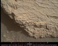
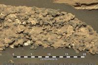
Another 1714 MAHLI of a target to the right of 'Prays Brook'. Shows some nice surface textures...
Scaled using Gerald's Ruler, so only applicable to 'in-focus portions' of the image.
|
|
 |
 
|
|
|
Jun 5 2017, 02:41 AM
Post
#152
|
||
|
Senior Member Group: Members Posts: 2428 Joined: 30-January 13 From: Penang, Malaysia. Member No.: 6853 |
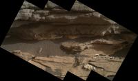
The focused merged MAHLI from 1714, no processing or sharpening, just stitched in MS ICE.
|
|
|
|
|
|
|
Jun 5 2017, 01:43 PM
Post
#153
|
||
|
Senior Member Group: Members Posts: 2428 Joined: 30-January 13 From: Penang, Malaysia. Member No.: 6853 |
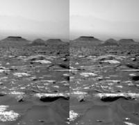
1717 L-NavCam, very roughly stitched pan (MS ICE) after a drive tosol... Reduced size and resolution to bring within the upload limit.
|
|
|
|
|
|
|
Jun 5 2017, 05:21 PM
Post
#154
|
|
|
Member Group: Members Posts: 923 Joined: 10-November 15 Member No.: 7837 |
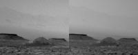
That looks like an intriguing mound to the East. Are we visiting the rock heap further south before swinging that way?
-------------------- |
|
|
|
|
Jun 5 2017, 07:27 PM
Post
#155
|
||
|
Senior Member Group: Members Posts: 2820 Joined: 22-April 05 From: Ridderkerk, Netherlands Member No.: 353 |
The Navcam L view on Sol 1717.
Jan van Driel
|
|
|
|
|
|
|
Jun 5 2017, 07:52 PM
Post
#156
|
||
|
Solar System Cartographer Group: Members Posts: 10153 Joined: 5-April 05 From: Canada Member No.: 227 |
Jan's sol 1717 panorama in circular form. The previously planned route was more to the east than the last few drives, so not sure where we are going in the near future.
Phil
-------------------- ... because the Solar System ain't gonna map itself.
Also to be found posting similar content on https://mastodon.social/@PhilStooke Maps for download (free PD: https://upload.wikimedia.org/wikipedia/comm...Cartography.pdf NOTE: everything created by me which I post on UMSF is considered to be in the public domain (NOT CC, public domain) |
|
|
|
|
|
|
Jun 5 2017, 10:40 PM
Post
#157
|
|
|
Member Group: Members Posts: 866 Joined: 15-March 05 From: Santa Cruz, CA Member No.: 196 |
|
|
|
|
|
Jun 6 2017, 06:58 AM
Post
#158
|
|
|
Senior Member Group: Members Posts: 2428 Joined: 30-January 13 From: Penang, Malaysia. Member No.: 6853 |
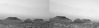
QUOTE (atomoid @ Jun 6 2017, 06:40 AM)  trying to get a handle on that capless mini-butte Is it Ireson Hill? |
|
|
|
|
Jun 6 2017, 12:10 PM
Post
#159
|
|
|
Senior Member Group: Members Posts: 2428 Joined: 30-January 13 From: Penang, Malaysia. Member No.: 6853 |
It's around 10 Sols since JPL issued RMI images as "Enhanced Data Products" (PNG files). Anyone here aware of the reason? Hopefully the process will start again soon
 |
|
|
|
|
Jun 6 2017, 12:47 PM
Post
#160
|
|
|
Member Group: Members Posts: 923 Joined: 10-November 15 Member No.: 7837 |
Ireson is way behind us to the North.
QUOTE (PaulH51 @ Jun 6 2017, 07:58 AM) Is it Ireson Hill? -------------------- |
|
|
|
|
Jun 6 2017, 01:17 PM
Post
#161
|
|
|
Founder Group: Chairman Posts: 14432 Joined: 8-February 04 Member No.: 1 |
QUOTE (PaulH51 @ Jun 6 2017, 05:10 AM) It's around 10 Sols since JPL issued RMI images as "Enhanced Data Products" (PNG files). Anyone here aware of the reason? Hopefully the process will start again soon A fix is underway. Pipeline issues. |
|
|
|
|
Jun 6 2017, 07:47 PM
Post
#162
|
|
|
Senior Member Group: Members Posts: 2428 Joined: 30-January 13 From: Penang, Malaysia. Member No.: 6853 |
QUOTE (djellison @ Jun 6 2017, 09:17 PM) A fix is underway. Pipeline issues. Many thanks
|
|
|
|
|
Jun 7 2017, 09:42 AM
Post
#163
|
||
|
Senior Member Group: Members Posts: 2820 Joined: 22-April 05 From: Ridderkerk, Netherlands Member No.: 353 |
The Navcam L view on Sol 1718.
Jan van Driel
|
|
|
|
|
|
|
Jun 8 2017, 09:36 AM
Post
#164
|
||
|
Senior Member Group: Members Posts: 2428 Joined: 30-January 13 From: Penang, Malaysia. Member No.: 6853 |
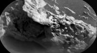
QUOTE (PaulH51 @ Jun 3 2017, 08:55 AM) A rather interesting outcrop, erosion features, or some sort of pebbles in the mudstone? Sol 1710 MastCam, added scale bar [attachment=41494:1710MR_S...ng_Ledge.JPG] A very rough RMI mosaic of a small section of the outcrop (jpeg version)
|
|
|
|
|
|
|
Jun 8 2017, 11:08 AM
Post
#165
|
||
|
Senior Member Group: Members Posts: 2428 Joined: 30-January 13 From: Penang, Malaysia. Member No.: 6853 |
Interesting R-MastCam from 1718 (Pre-drive) Cropped with added scale bar.
|
|
|
|
|
|
|

|
Lo-Fi Version | Time is now: 27th April 2024 - 10:17 AM |
|
RULES AND GUIDELINES Please read the Forum Rules and Guidelines before posting. IMAGE COPYRIGHT |
OPINIONS AND MODERATION Opinions expressed on UnmannedSpaceflight.com are those of the individual posters and do not necessarily reflect the opinions of UnmannedSpaceflight.com or The Planetary Society. The all-volunteer UnmannedSpaceflight.com moderation team is wholly independent of The Planetary Society. The Planetary Society has no influence over decisions made by the UnmannedSpaceflight.com moderators. |
SUPPORT THE FORUM Unmannedspaceflight.com is funded by the Planetary Society. Please consider supporting our work and many other projects by donating to the Society or becoming a member. |
|