Printable Version of Topic
Click here to view this topic in its original format
Unmanned Spaceflight.com _ Cassini's ongoing mission and raw images _ November 9 2006 icy moon encounters
Posted by: alan Nov 5 2006, 03:26 AM
Using the solar system simulator I found a pass ~100,000 km from Enceladus' south pole.
http://space.jpl.nasa.gov/cgi-bin/wspace?tbody=602&vbody=-82&month=11&day=9&year=2006&hour=00&minute=00&rfov=2&fovmul=-1&bfov=30&porbs=1&showsc=1
Any others planned for this orbit?
Posted by: Decepticon Nov 5 2006, 06:36 AM
Finally some Ice moons observations. Lacking as of late. 
Posted by: angel1801 Nov 5 2006, 08:36 AM
November 8-9 encounters:
Enceladus
Tethys
November 20-21 encounters:
Mimas
Dione
December 14-15 encouters:
Dione
Tethys
December 31 encounters:
Dione
Posted by: edstrick Nov 6 2006, 10:48 AM
Caution and Note: On the current high inclination orbits, the spacecraft plunges rapidly through Saturn's equatorial plane on the periapsis part of the pass. The result is that moderately encounters are possible with whatever moons happen to be near the plunge-point, but the trajectory won't stay in the equatorial plane and give relatively close encounters with other moons. An advantage is that moons will be able to be seen will be seen from one high "altitude" parts of the pass, giving better views of the poles than tends to be possible from equatorial orbits.
Posted by: angel1801 Nov 6 2006, 02:55 PM
The November 8-9 encounters of both Enceladus and Tethys are over high southern latitudes.
Enceladus at about 129,000km and Tethys at about 238,000km.
The November 20-21 encounters of Dione and Mimas are also both over high southern latitudes.
Mimas at about 175,000km and Dione at about 145,000km.
The Mimas encounter should fill alot of the gaps in Steve Alber's Mimas maps, especially near the south pole!
Posted by: Holder of the Two Leashes Nov 10 2006, 03:53 AM
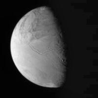
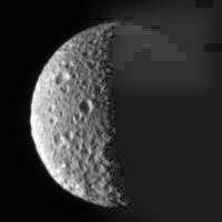
Two pics have come in so far, one of Enceladus and one of Mimas. Both fairly far out, about 400,000 km for each. Still, the Enceladus pic shows some better resolved... and interesting... features beyond the tiger stripes. This is on the upper left side in the raw picture. The stripes run almost horizontally from the terminator toward the left and downward just a little, and stop about halfway to the edge. This in the upper third of the half disk.
http://saturn.jpl.nasa.gov/multimedia/images/raw/raw-images-details.cfm?feiImageID=88503
http://saturn.jpl.nasa.gov/multimedia/images/raw/raw-images-details.cfm?feiImageID=88504
Posted by: angel1801 Nov 10 2006, 05:25 AM
The mimas image gives a very good view of it's south polar area. But we will see the same area at much better resolution on November 20-21.
The Enceladus image shows alot of the poorly seen areas at about 2.4km/pixel.
We will get much better resolution of these areas on May 27, June 28 and September 30 of next year.
Posted by: Phil Stooke Nov 12 2006, 03:21 PM
I've processed the Mimas and Enceladus pics a bit - you can't perform miracles with these JPEGs, but my interest is in making near-terminator features easier to see. There's a bit of Saturnshine on Mimas.
Phil
|
|
Posted by: TritonAntares Nov 13 2006, 11:47 PM
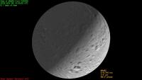
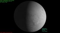
Let me add the view with Solar System Simulator:
Crosses mark the southpoles.
|
Mimas
|
Enceladus
And a map of known, unknown or mostly bad resolved regions at Enceladus southpolar cap:
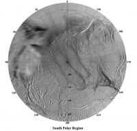
|
Bye.
Posted by: ugordan Nov 14 2006, 08:19 AM
Nice pictures, Phil. Sadly, from the looks of things, these two lone opnavs are the only images we'll be seeing from this periapsis pass. Due to a combination of bad timing on Cassini's part as well as bad timing on MGS's part and consequent recovery operations, all useful imaging data was lost.
Posted by: scalbers Nov 18 2006, 05:49 PM
Nice to see at least this one Enceladus image. So far I've been able to add a portion of this to my map, at moderately high southern latitudes near 0 degrees longitude. The latest version is at http://laps.noaa.gov/albers/sos/sos.html#ENCELADUS
Posted by: volcanopele Dec 22 2006, 05:35 PM
While ISS missed Enceladus on this encounter, CIRS got some decent data at Enceladus, revealing the hot spot at the south pole:
http://photojournal.jpl.nasa.gov/catalog/PIA09037
Posted by: scalbers Dec 22 2006, 09:23 PM
Interesting to see that both views over time show the same embedded cooler region between about 180 and 210 degrees longitude...
Posted by: scalbers Mar 3 2007, 05:59 PM
In relation to Enceladus I've been gradually adding some high resolution images of those fascinating mid-southern latitudes to my map. The most recent update is available at this URL:
http://laps.noaa.gov/albers/sos/sos.html#ENCELADUS
Posted by: ustrax Mar 3 2007, 09:08 PM

Great site. Great work!
Powered by Invision Power Board (http://www.invisionboard.com)
© Invision Power Services (http://www.invisionpower.com)