Rev205 and T102, Southern sub-Saturn temperate lake? |

  |
Rev205 and T102, Southern sub-Saturn temperate lake? |
 Jun 1 2014, 08:18 AM Jun 1 2014, 08:18 AM
Post
#1
|
|||
|
Member  Group: Members Posts: 699 Joined: 1-April 08 From: Minnesota ! Member No.: 4081 |
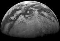
Rev205 (May 31 – Jul 2 ’14) has begun. http://www.ciclops.org/view/7892/Rev205 There is a Titan flyby (T102) and Cassini’s approach appears quite similar to T101. ISS will again image the southern sub-Saturn hemisphere. This will examine the interesting southern temperate zone where VIMS and ISS had imaged several temperate lakes just to the east of T102’s field of view. http://www.lpi.usra.edu/meetings/lpsc2012/pdf/2766.pdf Looking at that great ISS map one is drawn to a small dark region near 330 W and 45 S. This little place has had good VIMS http://photojournal.jpl.nasa.gov/catalog/PIA09034 and SAR (T50) coverage and I wonder if it is considered a temperate lake candidate?
|
||
 |
 
|
||
|
Jun 1 2014, 04:32 PM
Post
#2
|
||
|
Member Group: Members Posts: 699 Joined: 1-April 08 From: Minnesota ! Member No.: 4081 |
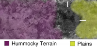
This area of T50 appears not to have been characterized as a geomorphic unit and sits between Hummocky and Plains terrains. SarTopo suggest its relatively low in elevation and there may be a draining channel or two nearby. Perhaps someone has denoised and destriped the PDS version of this area; that may help decide its morphology. (? JohnVV)!
|
|
|
|
|
|
|
Jun 9 2014, 09:29 PM
Post
#3
|
|
|
Member Group: Members Posts: 890 Joined: 18-November 08 Member No.: 4489 |
i did not see this until today
tonight i can grab the pds image and process it then post different levels of denoising imported the file "BIBQI28S319_D181_T050S01_V02.IMG" into ISIS and exported a raw normalized to 1,65535 rotated 270 Deg. and cropped the area 1) original image 2) denoised with detail 3) denoised with less detail 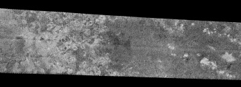 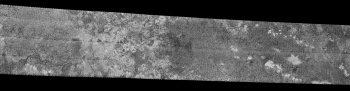  a G+ album https://plus.google.com/u/0/photos/10269590...168099862280065 to remove the horizontal seams will require some more work |
|
|
|
|
Jun 11 2014, 04:53 AM
Post
#4
|
|
|
Member Group: Members Posts: 890 Joined: 18-November 08 Member No.: 4489 |
my apologizes with the move from my 100% public Picasa albums to the G+ royally "bleeped"-up G+ albums
new folders are NOT being automatically made public the above G+ link is NOW public |
|
|
|
|
Jun 13 2014, 03:08 AM
Post
#5
|
|
|
Member Group: Members Posts: 699 Joined: 1-April 08 From: Minnesota ! Member No.: 4081 |
Not a problem John VV; thanks for the link and images. Not sure what this structure is. ? mainly a patch of dark dunes or perhaps a shallow lake or playa bottom.? Perhaps VP might comment.
|
|
|
|
|
Jun 13 2014, 03:23 AM
Post
#6
|
|
|
Member Group: Members Posts: 890 Joined: 18-November 08 Member No.: 4489 |
the radar data is reflectance the light areas are rough and the dark is smooth
( the same type as the venus data ) so i would expect that dark area to be a lake .Like a small lake in a marsh here on earth .  a crop of the PDE noise reduced area if i remove TOO much noise it becomes a bit blurry unlike the venus data this is very VERY noisy .So if i work it too much the data starts to become "artificial"( inpainted) or "flat" depending on the way i denoise |
|
|
|
|
Jun 13 2014, 06:33 AM
Post
#7
|
|
 Member Group: Members Posts: 444 Joined: 1-July 05 From: New York City Member No.: 424 |
I have a question about references in this thread to the "temperate zones" of Titan.
Has Titan, like the Earth, been separated Phil Stooke and his colleagues into major zones separated by great circles of latitude, with the northern temperate zone bounded to the North by Titan's Arctic Circle at 66.5° north latitude and to the south by the northerly tropic circle (I don't suppose it's called the tropic of cancer) at 23.5° north latitude? Or is the term "temperate zone" a more ad hoc one, referring to warmer spots where the contents of Titan's lakes are not frozen? My Google due-diligence on the question mostly returned articles about mythology and video games . . . Cheers, TTT Edited to correct a misspelling. This post has been edited by Tom Tamlyn: Jun 13 2014, 06:49 AM |
|
|
|
|
Jun 13 2014, 02:22 PM
Post
#8
|
|
 Senior Member Group: Moderator Posts: 2785 Joined: 10-November 06 From: Pasadena, CA Member No.: 1345 |
Titan does seem to be latitudinally stratified. Equatorial dunes, mid-lat stuff, empty lakes, and filled lakes, in the Northern hemisphere. Sorta-kinda similar but a little bit drier in the South.
The term for the Titan's mid-latitudes is officially the "Titan's mid-latitudes", and unofficially "the Blandlands". "Desolate plains" has also been used. There is no solid (!) evidence that Titan's lakes are frozen. Titan is just a tad too warm, even at the poles. There is a very small difference between the equatorial temperatures (95 K) and the polar temperatures (91 K). But even that is just enough to mess (!) with the expected equilibrium ratio of nitrogen/methane/ethane/propane in the lake fluids. If the lakes are in equilibrium with the atmosphere (which may not be the case), polar lake fluids would have a different equilibrium concentration than temperate lakes. One estimate of these values is in Cordier et al., 2009. (freely available here, check out table 3 in the text: http://iopscience.iop.org/1538-4357/707/2/..._707_2_L128.pdf. Local humidity can also be a driver and affect evaporation rates thus composition. At equilibrium, humidity (actual vapor pressure vs. saturation vapor pressure) is 100%. If the equatorial areas are drier, they could affect evaporation rates and the mix of lake composition. Methane is most volatile (nitrogen dissolves into methane, so it gets affected, too.) Ethane is not volatile (but could evaporate on a long enough time-scale. We are talking multi-year climate timescale.) Propane is seriously not volatile (Myr timescale????) 1-Butene is not predicted to be produced by atmospheric chemistry models to any appreciable extent. But if a puddle of that material were present, it would not evaporate, even on geological timescales. -------------------- Some higher resolution images available at my photostream: http://www.flickr.com/photos/31678681@N07/
|
|
|
|
|
Jun 14 2014, 12:12 AM
Post
#9
|
|
|
Member Group: Members Posts: 890 Joined: 18-November 08 Member No.: 4489 |
the area in question is at -45 Lat and 330 ( -30 ) Long
a map projected ( simple cylindrical ) image with some of the stripping removed North is UP  G+ "photo" image https://plus.google.com/u/0/photos/10269590...901291398562941 |
|
|
|
|
Jun 18 2014, 01:37 AM
Post
#10
|
|
|
Member Group: Members Posts: 699 Joined: 1-April 08 From: Minnesota ! Member No.: 4081 |
Two nice discussions about the T102 (and previous T101) flybys are now found on the Cassini mission homepage. http://saturn.jpl.nasa.gov/news/cassinifea...eature20140617/
http://saturn.jpl.nasa.gov/mission/flybys/titan20140618/ |
|
|
|
|
Jun 20 2014, 05:46 AM
Post
#11
|
||
 Lord Of The Uranian Rings Group: Members Posts: 798 Joined: 18-July 05 From: Plymouth, UK Member No.: 437 |
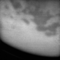
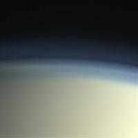
A shot of Kraken Mare from just the other day:
-------------------- |
|
|
|
|
|
|
Jun 20 2014, 08:11 PM
Post
#12
|
||
|
Lord Of The Uranian Rings Group: Members Posts: 798 Joined: 18-July 05 From: Plymouth, UK Member No.: 437 |
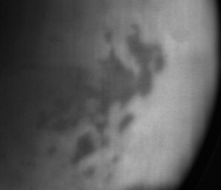
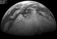
This is a fairly rough-and-ready (some might say grotty, even) 4-frame NAC mosaic, encompassing the entirety of the northern wetlands:
-------------------- |
|
|
|
|
|
|
Jun 21 2014, 05:52 AM
Post
#13
|
|||
|
Member Group: Members Posts: 699 Joined: 1-April 08 From: Minnesota ! Member No.: 4081 |
Some more T102 flyby images
RGB composite
Four of the approach images from about 250K km CB3 filter.
|
||
|
|
|
||
|

|
Lo-Fi Version | Time is now: 23rd April 2024 - 11:27 PM |
|
RULES AND GUIDELINES Please read the Forum Rules and Guidelines before posting. IMAGE COPYRIGHT |
OPINIONS AND MODERATION Opinions expressed on UnmannedSpaceflight.com are those of the individual posters and do not necessarily reflect the opinions of UnmannedSpaceflight.com or The Planetary Society. The all-volunteer UnmannedSpaceflight.com moderation team is wholly independent of The Planetary Society. The Planetary Society has no influence over decisions made by the UnmannedSpaceflight.com moderators. |
SUPPORT THE FORUM Unmannedspaceflight.com is funded by the Planetary Society. Please consider supporting our work and many other projects by donating to the Society or becoming a member. |
|