Printable Version of Topic
Click here to view this topic in its original format
Unmanned Spaceflight.com _ Opportunity _ Heading south from Cape York
Posted by: Phil Stooke Apr 27 2013, 08:16 PM
Time for a new thread... we should be starting up right about now after conjunction, and if no other targets have popped up our plucky rover should be heading south within days. This should be quite a scenic trip, so sit back and enjoy the fun.
Phil
Posted by: fredk Apr 27 2013, 08:53 PM
Good timing, Phil - the first post-conjuction pics are coming in now:
http://qt.exploratorium.edu/mars/opportunity/pancam/2013-04-27/1P419822192ESFBY00P2651R8M1.JPG?sol3285
Now we know the sun's still shining on Mars! 
Posted by: mhoward Apr 27 2013, 09:18 PM
Technically we haven't seen any images from the last 6 sols or so yet, but I'm going to take a leap of faith and assume those will be coming soon.
Posted by: mhoward Apr 29 2013, 11:19 PM
http://solarsystem.nasa.gov/news/display.cfm?News_ID=43484
Adding: @mikeseibert on Twitter says "Oppy should be back to regular operations after tomorrow's uplink. #knockonwood" So let's knock on wood.
Posted by: eoincampbell Apr 30 2013, 01:25 AM
If that's the case I'm off to listen to Tony Orlando...
Posted by: Tesheiner Apr 30 2013, 08:40 AM

And look what's included on "tomorrow's uplink".

03294::p1154::01::2::0::0::2::0::4::front_hazcam_idd_unstow_doc
03294::p1165::00::1::1::0::0::0::2::flhaz_IDD_check_subframe_2bpp_pri_41
03294::p1201::07::2::0::0::2::0::4::front_haz_penultimate_1bpp_pri17
03294::p1214::05::2::0::0::2::0::4::front_haz_ultimate_4bpp_pri15
03294::p1234::06::2::2::0::0::0::4::front_haz_fault_half_pri15_4bpp
03294::p1254::02::2::0::0::2::0::4::front_haz_fault_pri15_4bpp
03294::p1301::06::2::0::0::2::0::4::rear_haz_penultimate_1bpp_pri17
03294::p1334::00::2::2::0::0::0::4::rear_haz_fault_half_pri15_4bpp
03294::p1354::01::2::0::0::2::0::4::rear_haz_fault_pri15_4bpp
03294::p1939::05::2::0::0::2::0::4::navcam_idd_doc_1_bpp_pri_15
03294::p1960::05::2::0::0::2::0::4::nav_1x1_az0_El_neg50_4bpp_pri16
03294::p2601::05::4::2::0::0::2::8::pancam_tau_L78R48

Posted by: mhoward Apr 30 2013, 08:57 AM
As they say on the Internet: "Squee!"
Posted by: RoverDriver Apr 30 2013, 04:49 PM
Actually it will be a teeny tiny drive. In fact it will be my shortest drive ever. So short we had to devise a trick to actually command such a small motion by combining two slightly larger ones. But at least it is
Paolo
Posted by: mhoward Apr 30 2013, 07:11 PM
Oh well, any is good
Posted by: nprev May 1 2013, 03:19 AM
This is being widely reported right now:
http://www.nasa.gov/mission_pages/mer/news/mer20130429.html

Posted by: dtolman May 1 2013, 03:41 AM
So is Oppy up and running, or was that premature optimism and they're still trying to regain control?
tl;dr -  or ?
or ?
Posted by: jamescanvin May 1 2013, 07:40 AM
I don't think there is any reason to be worried at this point.
I know we're all in withdrawal but hang in there folks, I'm sure we'll get our fix soon.
Posted by: mhoward May 1 2013, 09:38 PM
http://solarsystem.nasa.gov/news/display.cfm?News_ID=43484 has been updated today to confirm that Opportunity has resumed normal operations.
(Still waiting for new images though.)

Posted by: brellis May 1 2013, 10:48 PM
Our beloved Rover Driver was featured in a http://www.bbc.com/future/story/20130501-getting-stuck-in-a-rut-on-mars today
Posted by: fredk May 3 2013, 03:55 AM
From the http://www.planetary.org/explore/space-topics/space-missions/mer-updates/2013/04-mer-update-opportunity-emerges-from-conjunction.html, some more details about plans:
Posted by: mhoward May 3 2013, 04:21 AM
And, per the more immediate plan, Opportunity bumped slightly to the right today (3296). Lots of good info in the Update, as usual.
Posted by: fredk May 8 2013, 02:30 PM
Tau has jumped a lot in the past week or so, from around the 0.7 level where it's been for a long time up to 1.5 on 3301, as http://www.lpl.arizona.edu/~lemmon/mars-tau-b.html shows. This is the highest it's been this Martian year, although as you can see from the chart, we've had very similar jumps at the same solar longitude in previous years. So hopefully it will drop back down quickly (within a couple of weeks), as it has in the past.
The increased dust is very obvious in both the lightness of the shadows and the haziness of the far rim of Endeavour by comparing these views from 3296 and 3301:
http://qt.exploratorium.edu/mars/opportunity/forward_hazcam/2013-05-02/1F420797168EFFBY08P1201R0M1.JPG?sol3296
http://qt.exploratorium.edu/mars/opportunity/forward_hazcam/2013-05-07/1F421239422EFFBY08P1148R0M1.JPG?sol3301
Posted by: Tesheiner May 8 2013, 03:53 PM
I was reading again the http://www.planetary.org/explore/space-topics/space-missions/mer-updates/2013/04-mer-update-opportunity-emerges-from-conjunction.html this morning. If the plan is still the same, the above FHAZ image may be one of the last ones from this site.
Posted by: fredk May 9 2013, 12:16 AM
From the http://www.msss.com/msss_images/2013/05/08/
Posted by: Tesheiner May 9 2013, 10:15 AM
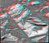
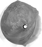
Here's an MI mosaic from the images taken during sol 3301.
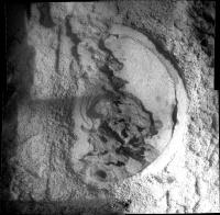
|
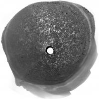
Now I understand Squyres' comment to TPS: Esperance, however, is a difficult target to say the least. "This vein is just about as nasty a RAT target as you can imagine," said Squyres. "It's irregular, tiny, and has newberries surrounding it which complicate the task."
Posted by: atomoid May 10 2013, 08:25 PM
thanks for the nice mosaic, for a second it carried me back to the other thread looking at an orbital view of Gale..!
Posted by: fredk May 15 2013, 05:09 PM
It looks like we're on our way:
http://qt.exploratorium.edu/mars/opportunity/forward_hazcam/2013-05-15/1F421864208EFFBYAEP1211R0M1.JPG?sol3308
Posted by: Tesheiner May 15 2013, 05:51 PM
Yeah!!
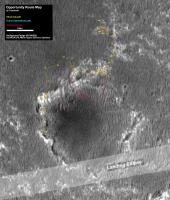
Looking at the "telemetry" I read something like 24m due south. A proper map update will have to wait 'til tomorrow when I'm back home.
Posted by: climber May 15 2013, 09:19 PM
We hit the road, Jake!
(thanks for everything)
Posted by: jamescanvin May 16 2013, 10:10 AM
And a further 80m tosol (3309)
Posted by: climber May 16 2013, 04:10 PM
So, we're now about 140 mere meters from Apollo 17th rover record. I'll expect Oppy will be n°2 quite soon, still 1.1 km short to pass Lunakhod 2. GoOppy, go
Posted by: marsophile May 16 2013, 09:58 PM
http://en.wikipedia.org/wiki/Lunokhod_2
The Lunokhod 2 achieved its distance record in about 6 months.
Contributing to this, the top speed of the rover was about 1.2 MPH compared to the MER and MSL rover speeds of about 0.1 MPH.
Opportunity may break the distance record, but I think it will be some time before the speed record is broken!
Posted by: Ant103 May 16 2013, 11:15 PM
The beginning of a new journey is for me the occasion to going back to some imagery That was a long time not stitching and coloring these picture from our old little girl .
Sol 3303 - Dusty atmosphere this sol :
http://www.db-prods.net/marsroversimages/Opportunity/2013/Sol3303_pancam.jpg
And a last Navcam pan before the move :
http://www.db-prods.net/marsroversimages/Opportunity/2013/Sol3308_pano.jpg
(And also, a new gallery with a timeline, just like Curiosity http://www.db-prods.net/marsroversimages/opportunity-2013.html )
Posted by: Ron Hobbs May 16 2013, 11:23 PM
JPL has made it official:
"The team operating NASA's Mars Exploration Rover Opportunity received confirmation in a transmission from Mars today that the rover drove 263 feet (80 meters) on Thursday, bringing Opportunity's total odometry since landing on Mars in January 2004 to 22.220 statute miles (35.760 kilometers)."
http://www.jpl.nasa.gov/news/news.php?release=2013-166
Hey, I think it so cool that Gene Cernan is talking to the MER Team about this.
And it looks like the Lunakhod 2 record is not far from being broken. Go Oppy!
Ron
Posted by: jamescanvin May 17 2013, 09:45 AM
And ~95m more tosol (3310)
Posted by: Phil Stooke May 18 2013, 12:02 AM
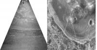
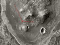
Quick look at some features just ahead in a stretched view of the Navcam frame.
Phil

|
Posted by: Phil Stooke May 18 2013, 01:25 AM
James tweeted: "Oppy sol 3310 - Took pancam images of Karratha & Corunna Downs. Then drove 95m SW along Cape York. "
Do we know yet which features these are?
Phil
(always hungry for feature names)
Posted by: SFJCody May 18 2013, 07:57 AM
Looks like there's another drive coming up for sol 3312.
Posted by: mhoward May 18 2013, 03:50 PM
We haven't seen many images come down yet, so it's hard to be sure. Here's my estimate based on what we do have, though. This is seen from site 170/0114 (sol 3308), below "Kirkwood".
I hope we'll see some more images soon, so I can find out if I was right! (And so we can have some more images.)
Edit: Oops, mispelled "Corunna" in the image. Lack of coffee, etc.

|
Posted by: Ant103 May 18 2013, 09:36 PM
Sol 3308 panoramic updated :
http://www.db-prods.net/marsroversimages/Opportunity/2013/Sol3308_pano.jpg
And the Pancam drive direction
http://www.db-prods.net/marsroversimages/Opportunity/2013/Sol3308_pancam.jpg
Posted by: fredk May 18 2013, 10:08 PM
Thanks, Ant. Isn't it great to see drive-direction pancams again?
Based on the drives so far, it looks like the plan may be to hug the "coast" of CY, just inland, rather than driving straight for Solander Point.
Posted by: Tesheiner May 19 2013, 12:54 AM
Actually, I'm wondering if she will do a quick stop near Odissey to image those old tracks around it.
Posted by: centsworth_II May 19 2013, 09:01 AM
According to the last http://www.planetary.org/explore/space-topics/space-missions/mer-updates/2013/04-mer-update-opportunity-emerges-from-conjunction.html
"We calculated a rapid transit... " Arvidson informed. "....This route allows for a short stop at Nobby's Head so that the rover can take some stereo images of the northern side of hill for engineering characterization of slopes, just in case we need a possible bail-out location for winter, but other than that it's a path that will take Opportunity to Solander as quickly as possible..."
Illustrated in the March 1, 2013 entry http://www.nmnaturalhistory.org/rover-field-reports-from-mars.html
|
Posted by: Astro0 May 19 2013, 12:58 PM
Just bck to Opportunity's driving record, there's a nice little poster on vehicle driving distances (Moon and Mars) over on i09.
http://io9.com/the-records-for-the-greatest-distances-driven-on-mars-a-508328297
Back to the drive south
Posted by: fredk May 19 2013, 03:44 PM
Posted by: Phil Stooke May 19 2013, 04:16 PM
This looks like a good place to add a note of caution about Lunokhod driving distances. They will have to be recalculated based on the LROC images. When the actual Lunokhod 2 tracks are compared with the original Soviet-era map, it looks to me like they landed slightly north of the expected location, drove a bit further south than they thought, then east, and finally ended up further north than they thought. Some extra distance will probably come out of a recalibration of the drives (maybe they allowed for more wheel slip than actually occurred). A new mapping effort is under way at MIIGAiK - they already did Lunokhod 1 and are working on Lunokhod 2. Maybe by LPSC next year we will have a result. Just a caution - we might break the record and then have to break it again!
Phil
Posted by: Phil Stooke May 19 2013, 04:35 PM
Don't just read that great site by Larry Crumpler - those images, especially the maps, can stand a considerable amount of enlargement. Lots of good stuff! Too bad there doesn't seem to be an archive of past reports like these.
Phil
Posted by: Phil Stooke May 19 2013, 04:39 PM
Another drive...
http://qt.exploratorium.edu/mars/opportunity/navcam/2013-05-19/1N422223111EFFBY%23%23P0713L0M1.JPG
Phil
Posted by: climber May 19 2013, 05:17 PM
Did you also notice that we (I on the Spirit & Oppy Statistics) used to get 35890 for Apollo 17 rover and this is also used on the New Mexico Museum's but Nasa says 35744...and tthey can't be wrong 
Phil, do you think all Moon driving distances will have to be reevaluated?
Thanks
Posted by: Phil Stooke May 19 2013, 05:24 PM
Apollo should be much better than Lunokhod because they had high resolution orbital images and lots of backup position data. I would not have expected much change for Apollo distances. I will look into the difference in those numbers.
Phil
Posted by: Tesheiner May 19 2013, 06:58 PM
http://qt.exploratorium.edu/mars/opportunity/navcam/2013-05-19/1N422223111EFFBY%23%23P0713L0M1.JPG
Phil
Similar distance as on the previous one: 95m. One more drive and we may be reaching the 36km mark.
Posted by: serpens May 19 2013, 11:13 PM
Phil, do you think all Moon driving distances will have to be reevaluated?
Did they zero the odometer before deployment or did it still have acceptance test distance logged, compensated for in the distance / direction from start point software? ie. The distance on moon will be less than the total recorded? Comparing the Apollo rovers to the MER is really a chalk and cheese approach and the outcomes depend on how you squint when assessing. For example: if you look at distance and time deployed the Apollo 15 rover is the champ. 0.152 kilometers per minute. Apollo 17 comes in second at 0.135. Opportunity can go down in history as the slowest ever rover in terms of distance /time.

Posted by: dvandorn May 20 2013, 12:08 AM
Yes, they zeroed the nav system several times during the EVAs. And the system only told you the range and bearing back to the LM. Total odometry was calculable from this (it was calculated on wheel turns), but was considered somewhat of a "dead reckoning" system. Wheel slippage and meander to avoid rocks and craters meant that the nav system would get you back to where you could see the LM and drive back to it by eye. No one ever pretended that it could tell you within a few meters *exactly* where you were or how far you had driven.
On the LRV, the range and bearing were more often used in finding the planned station stops, and due to the various small detours and wheel slips these readings usually varied from the pre-mission calculated values, even when the slight variations in landing point were taken into account.
All this is to say that you'd have to do the kind of detailed wheel-track analysis they're now doing with the Lunakhods to get the absolute exact distance traveled by any of the LRVs. There is a "wander factor" in the LRV nav data that makes all calculations based on them somewhat approximate.
-the other Doug
Posted by: djellison May 20 2013, 03:58 AM
You could make up a million different statistics all pretty much as meaningless as the next. Distance travelled vs average distance from earth. Distance travelled per KG of vehicle mass. Number of individual drives. Number of locations visited. Total longevity etc etc etc
Posted by: brellis May 20 2013, 07:25 AM
Interesting stats would be long distance targets like Endurance or Victoria or Endeavor and what was the average drive length when heading towards these goals. Before embarking on the trek to Endeavor folks were doing some math about how long it would take.
btw, didn't we have a pool guessing the arrival date at Endeavor?
Posted by: elakdawalla May 20 2013, 02:53 PM
We had one long-running poll here years back and the back-and-forth arguing both during the drive and after the goal was reached became so annoyingly dull that polls have been banned here ever since.
Posted by: Ant103 May 20 2013, 03:11 PM
Sol 3312 panoramas :
Navcam
http://www.db-prods.net/marsroversimages/Opportunity/2013/Sol3312_pano.jpg
Pancam, drive "yes it's good to read drive " direction :
http://www.db-prods.net/marsroversimages/Opportunity/2013/Sol3312_pancam.jpg
Posted by: serpens May 20 2013, 10:36 PM
Exactly my point. Comparing the distance achieved by a lunar 'car' and a martian robotic rover is meaningless. The really big deal is comparing the longevity and distance achieved by Opportunity compared to design requirements and mission success parameters. I have used Opportunity as an example of outstanding reliability engineering and remote diagnosis and rectification. I stand in awe of those who designed and built her.
Posted by: MahFL May 21 2013, 01:00 PM
JPL engineers admitted the MER's were overengineered and that the 90 day mission time was very likely to be exceeded, barring some unforseen problem. So comparing to the 90 day required time is not really a valid reference point. The main reason Sprit died was it got trapped in sand and could not tilt it's solar panels to the Sun. That of course could have happend on the first drive if fate had meant that to happen.
Posted by: djellison May 21 2013, 01:45 PM
I assume you mean MER.
I can assure you - all mechanisms etc are tested to 3x the required lifetime. That's not 'over engineered' - that's called engineering margin to guarantee a good shot at reaching your requirements. It's JPL policy. It puts the bellcurve of expected failure centered beyond 90 days.
Squyres has been on record - years after landing - saying he thought maybe 120, if everything went perfectly maybe 180 sols. I'd be interested in exactly where you see JPL engineers describing MER as 'overengineered'. That's not a phrase I've ever heard them use. Required engineering margin....yes. Not 'overengineered'
Plus - the dust was STILL expected to kill the rovers very shortly after 90 sols. This paper by the late great Jake Matijevic details the expected liftspan of the rovers...
http://trs-new.jpl.nasa.gov/dspace/bitstream/2014/11979/1/02-0732.pdf
Slide 3 explicitly states that the expected useful lifespan of the rovers was 100 sols for MER-B at the 'Hematite' site ( aka Meridiani ) and 92 sols for MER-A at Gusev.
So - maybe you might find an engineer on Sol 500 saying "We obviously tested for more than 90 sols". But BEFORE launch - I challenge you to find any engineer on record stating they expected the rovers to last significantly longer than 90 days. I don't think you'll find it.
Posted by: MahFL May 21 2013, 02:42 PM
I think I may have equated 'margin' with 'over engineering'.
I still think though the team was staying with the 90/180 day thing, as the costs for a 10 year mission would not have been at the time favorably looked at by the beancounters......  . There was even conjecture at one time one rover would be turned off to save said beans
  .
.
Posted by: RoverDriver May 21 2013, 02:52 PM
btw, didn't we have a pool guessing the arrival date at Endeavor?
I counted 999 Sols, Distance 21.12285 Km, 357 drives, 21.14 meters/sol 59.17 meters/drive
Paolo
Posted by: vikingmars May 21 2013, 03:52 PM
Thanks a lot Ant103 : those views are impressive in the sense they show a virgin territory yet to be explored in front of us, really devoided of any tracks and marks.
A real sence of loneliness here from your pics. This is what I call an "unknown territory" !
Posted by: djellison May 21 2013, 04:11 PM
And the paper I linked to proves otherwise.
Posted by: Tesheiner May 21 2013, 08:35 PM
Here's an "enhanced version" of a FHAZ image taken during sol 3314.
|

Posted by: climber May 21 2013, 08:50 PM
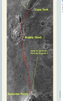
I don't intend to be as precise as you are Eduardo, but Lunokhod 2's mark will be around there pending we detour to Nobby's Head as "scheduled", right?
This is to show how close we are.
|
Posted by: ngunn May 21 2013, 09:13 PM
There are some bumps on the horizon to the right. Is that Nobby head, Sutherland point or neither? What are we looking at?
Posted by: fredk May 22 2013, 03:06 AM
We're now just starting to see Nobby's Head peeking around the side of CY. We had good views of it and Sutherland Point when we arrived at CY, but once we arrive at the south end of CY we should have a different view, since we'll be below Spirit Point/Odyssey, so Nobby/Sutherland may stick above the horizon.
Posted by: eoincampbell May 22 2013, 06:28 AM
That's great climber, just what we need to see ...for now...
Posted by: jamescanvin May 22 2013, 11:36 AM
Right on the edge of Cape York now, Nobby's Head/Sutherland Point ahead.
http://www.midnightplanets.com/web/MERB/image/03315/1N422477356EFFBZCUP0723R0M1.html
Posted by: fredk May 22 2013, 02:28 PM
Fasten your seatbelts and take your gravol - the drive may get a little bumpy as we cross the choppy seas of Botany Bay!
Posted by: Phil Stooke May 23 2013, 02:10 PM
http://qt.exploratorium.edu/mars/opportunity/navcam/2013-05-23/1N422571856EFFBZJVP0733L0M1.JPG
Yes, a bit bumpy - now we have a clear view of Sutherland Point up ahead.
Phil
Posted by: ngunn May 24 2013, 09:19 PM
This navcam shot is a treat. Level horizon with interesting destination, sundial in the foreground and dramatic lighting: it has everything. Worthy of some artistic treatment in my view.
http://qt.exploratorium.edu/mars/opportunity/navcam/2013-05-24/1N422664439EFFBZW8P0733L0M1.JPG
Posted by: James Sorenson May 25 2013, 05:44 AM
I agree.

|
Posted by: Tesheiner May 25 2013, 07:21 AM
This pancam mosaic was taken right after that navcam shot. The view of Sutherland Point is improving.

|
Posted by: Phil Stooke May 25 2013, 08:47 PM
It's been a while since I did one of these vertical stretches - but here I think it helps to relate the horizon detail with the HiRISE image and see where we are and what's coming up. Nobby's Head is still partly hidden from view.
Phil

|
Posted by: Ant103 May 26 2013, 09:30 AM
Sol 3317 panoramas The view to Sutherland Point is very good !
http://www.db-prods.net/marsroversimages/Opportunity/2013/Sol3317_pano.jpg
http://www.db-prods.net/marsroversimages/Opportunity/2013/Sol3317_pancam.jpg
Posted by: udolein May 26 2013, 07:38 PM

Artefact or something real ?
Sol 3314, local time between 02:03 and 02:21 pm. 12 images with 1 min separation between the single images.
Cheers, Udo
Posted by: Phil Stooke May 26 2013, 08:44 PM
I assume the automatic routine that makes a small window around the sun is following the sun across the frame (rather than the camera trying to track the sun), so one hot pixel in the detector will appear to move.
Phil
Posted by: fredk May 26 2013, 09:38 PM
Phil's got it. The solar neutral density filter used in those images absorbs so much light that any star/planet/meteor/satellite would be completely invisible.
Posted by: Phil Stooke May 28 2013, 03:21 PM
http://qt.exploratorium.edu/mars/opportunity/navcam/2013-05-28/1N422650186EFFBZJVP1637R0M1.JPG
Very close to the new 'island' in Botany Bay now!
(oops! Mike just told me that one's looking backwards at Cape York just after leaving it - sorry about that, folks!)
Phil
Posted by: Bill Harris May 28 2013, 04:58 PM
Nice geologic contact, there...
--Bill
Posted by: mhoward May 28 2013, 07:28 PM
Yes, there's a bunch of Pancam images that should come down eventually mostly have come down.
Today we're treated to a lovely Navcam look back at Cape York, amongst other things. Odyssey Crater is just left of the North marker in this view.

|
Posted by: Phil Stooke May 28 2013, 08:01 PM
http://qt.exploratorium.edu/mars/opportunity/navcam/2013-05-28/1N422650674EFFBZJVP1637R0M1.JPG
Big dust devil on the slope below Cape Tribulation - or wind gust.
Phil
Posted by: mhoward May 28 2013, 08:14 PM
Ooh, nice. Sol 3317.
Posted by: Phil Stooke May 28 2013, 08:17 PM
I have noticed hints of wind activity on those slopes in the last two weeks or so, but not so obvious. Now we need to get one a bit further north!
This is a very faint DD lower down the hill on sol 3308.
http://marsrovers.jpl.nasa.gov/gallery/all/1/n/3308/1N421855083EFFBYAEP0713L0M1.JPG
Phil
Posted by: fredk May 28 2013, 08:26 PM
Nice catch, Phil. Since the navcam imagery is only momentary, we're probably missing many gusts/dds. We had a cleaning event between 3311 and 3315 - let's hope for more.
Can you post any of those tentative gust images, Phil?
Edit - thanks!
Posted by: Phil Stooke May 28 2013, 09:54 PM

|
This is the faint thingy in that image (its base is half way from horizon to bottom of frame) ... of course, the more I look at it the less I beieve it now. But comparison with other images suggests there is a faint vertical streak here. I had another one higher up in another image but can't find it now.
Phil
Posted by: eoincampbell May 29 2013, 01:00 AM
Yes, a marvelous goodbye cross-section view, explaining some of the slopes on CY...
Posted by: CosmicRocker May 29 2013, 02:26 AM
Nice catch! Are we going to get this view in pancams?
Posted by: mhoward May 29 2013, 02:49 AM
Doesn't seem so at the moment, but I don't know what the future may hold. There's an albedo pan from the current position coming, but it falls just under Odyssey / CY, if that's the view you mean.
Posted by: CosmicRocker May 29 2013, 04:37 AM
I just want to see that "marvelous goodbye cross-section view"...or that "lovely lookback" in pancams.
Posted by: fredk May 29 2013, 02:17 PM
It's also clearly visible in both L and R frames, so I'd say it is real.
Posted by: Ant103 May 29 2013, 03:03 PM
Leaving Cape York, the "big picture" (Sols 3317 & 3318)
http://www.db-prods.net/marsroversimages/Opportunity/2013/Sol3317-3318_pano.jpg
And Sol 3317 view of Endeavour.
http://www.db-prods.net/marsroversimages/Opportunity/2013/Sol3317_pano2.jpg
Maybe it's Postcard time ?
http://www.db-prods.net/blog/2013/05/29/opportunity-dit-adieu-a-cape-york/
I'm wondering about making a colorized version…
Posted by: Phil Stooke May 30 2013, 04:42 AM
Really nice mosaics! One thing they show clearly is how the hills all sit on a slope so the western side of the hill is nearly level and the eastern side is steeper. Remember when we approached Cape York and it was so hard to see it from a distance. For that reason it was easy to get 'up' onto the ridge of Cape York. But looking further south suggests the same will be true at Solander and even Cape Tribulation. They are steeper than Cape York, certainly, but it certainly looks like we can get all the way to the top of any of those hills from the west side.
I have been looking at the hills in HiRISE to see if the range of features visible at Cape York is also available further south. I especially hope to see networks of large filled cracks like we saw on Shoemaker Ridge but did not investigate at the time. So far I have not noticed anything like that, but maybe I have not looked at the best images yet.
Phil
Posted by: PaulM May 30 2013, 11:18 AM
Is there a comprehensive source of Lunakhod 2 pictures? I would love to see a movie taken by Lunakhod 2's "hazcams" as it drove over the 37 km. I guess that most probably these analogue "hazcam" views are lost. I have seen some of Lunakhod's pretty "navcam" views of hills and piles of rocks. However, I have never found more than about 20 different Lunakhod 2 photos.
Posted by: Hungry4info May 30 2013, 12:39 PM
This site seems to be the most comprehensive resource out there as far as I'm aware.
http://www.planetology.ru/panoramas/lunokhod2.php
Posted by: Phil Stooke May 30 2013, 02:48 PM
The TV images used for driving ('hazcams') were recorded on tape. When the Soviet Union fell apart the tapes were taken home by one of the participants who probably hoped to sell them at some point. That never happened and the tapes were recovered a few years ago. So far they have not been read and the images recovered, as far as I know - if they have nothing much has been done with them. But a lot of work is going on in this area now. I have had this from the people involved, especially Kira Shingareva.
Phil
Posted by: climber May 30 2013, 03:47 PM
Phil
Who's here on the same picture as yourself Phil, right? http://www.google.fr/imgres?um=1&sa=N&hl=fr&rlz=1T4ADBF_frFR294FR294&biw=1613&bih=816&tbm=isch&tbnid=pyANEUpa4C8BRM:&imgrefurl=http://airandspace.si.edu/ceps/ica/ottawa99.html&docid=WozOLiL11Q9iWM&imgurl=http://airandspace.si.edu/ceps/ica/icaimages/groupl.jpg&w=640&h=429&ei=9XOnUb-EI7HL0AW36IDAAQ&zoom=1&iact=hc&vpx=1098&vpy=136&dur=11341&hovh=184&hovw=274&tx=100&ty=110&page=1&tbnh=149&tbnw=230&start=0&ndsp=46&ved=1t:429,r:7,s:0,i:105
Posted by: Phil Stooke May 30 2013, 04:10 PM
Yes, third from the left.
Phil
Posted by: Phil Stooke May 30 2013, 06:43 PM
OK... Shirley they moved today.
http://qt.exploratorium.edu/mars/opportunity/navcam/2013-05-30/1N423192800EFFC000P0722R0M1.JPG
Phil
Posted by: mhoward May 30 2013, 06:54 PM
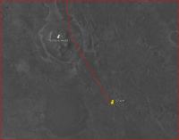
Yes; approximately 75m SW toward Sutherland Point on sol 3323. And stop calling us Shirley.
Adding: Here's an http://www.flickr.com/photos/marscat/8892256669/ from the sol 3323 location. We should be right next to that small crater along the way on the route map, so the next couple Navcam images to come down might be interesting.
Posted by: mhoward May 30 2013, 08:14 PM
And there it is: the small crater to the west on sol 3323. For a minute I thought it was not there. Very hard to make it out except in stereo; not what I was expecting to see!
http://www.flickr.com/photos/marscat/8893906947/
http://www.flickr.com/photos/marscat/8893906947/ on Flickr
Posted by: Phil Stooke May 31 2013, 01:32 AM
A bit clearer if we perspectivize it (is that even a word?)
Phil

|
Posted by: Ant103 May 31 2013, 11:19 AM
Sols 3317 & 3318 panoramic is getting full circular
http://www.db-prods.net/marsroversimages/Opportunity/2013/Sol3317-3318_pano.jpg
A small crater met at Sol 3314 :
http://www.db-prods.net/marsroversimages/Opportunity/2013/Sol3314_pancam.jpg
And the last panoramas, Navcam and Pancam, from Sol 3323. Clearer view on Sutherland
http://www.db-prods.net/marsroversimages/Opportunity/2013/Sol3323_pano.jpg
http://www.db-prods.net/marsroversimages/Opportunity/2013/Sol3323_pancam.jpg
Posted by: Phil Stooke May 31 2013, 04:30 PM
This is Ant103's Sol 3317-3318 panorama in circular format.
Phil
|
Posted by: mhoward May 31 2013, 05:36 PM
And here she is at "Sutherland Point" - or pretty close to it anyway - on sol 3324. The drive was about 79m southwest, more or less - probably more, since she didn't go in an exact straight line.
|
Posted by: Ant103 May 31 2013, 06:23 PM
This is like ve have Mars in live from Endeavour thes days
Today's pan, Sol 3324 :
http://www.db-prods.net/marsroversimages/Opportunity/2013/Sol3324_pancam.jpg
http://www.db-prods.net/marsroversimages/Opportunity/2013/Sol3324_pano.jpg
Posted by: Bill Harris May 31 2013, 06:36 PM
The ground at our feet is trying to tell us something. What do you suppose it is?
http://qt.exploratorium.edu/mars/opportunity/pancam/2013-05-31/1P422652753EFFBZJVP2372L2M5.JPG
--Bill
Posted by: fredk May 31 2013, 06:58 PM
That's the ground that was at our feet, back on 3317 when we had just left CY...
Posted by: centsworth_II May 31 2013, 07:05 PM
Posted by: serpens Jun 1 2013, 12:12 AM
Not quite. Botany Bay sulphates are supposed to be well hydrated in comparison to the plain. Perhaps it is just my ageing eyes but despite the lag of big juicy berries, embedded berries seem extremely sparse. - almost as though the lag originated external to the crater.
Posted by: centsworth_II Jun 1 2013, 02:39 AM
|
As seen in this http://www.unmannedspaceflight.com/index.php?s=&showtopic=681&view=findpost&p=43519
|
the left (sol 634) image is from the area labeled Olympia Outcrop here:

|
http://www.gps.caltech.edu/~grotz/Publications/Publications_files/2009_Metz_Erebus.pdf
(Edited to add route map and add "?" to scale comment.)
Posted by: ElkGroveDan Jun 1 2013, 03:21 AM
That we should all get rid of our trendy travertine tile kitchen flooring and go with the more pleasing sinuous appearance of a nice polished and sealed layered sandstone?
Posted by: Phil Stooke Jun 2 2013, 12:19 AM
Looks like we have now hopped up onto the bench surrounding Sutherland Point. More to follow.
Phil
Posted by: Phil Stooke Jun 2 2013, 02:12 AM
There's those gypsum veins again:
http://www.midnightplanets.com/web/MERB/image/03325/1P423369085EFFC0NSP2378R2M1.html
Phil
Posted by: SFJCody Jun 2 2013, 08:07 PM
A nice view of Solander Point & Cape Tribulation down thissol. Details becoming clearer.
http://qt.exploratorium.edu/mars/opportunity/pancam/2013-06-02/1P423362467EFFC0GHP2585L5M1.JPG
Posted by: Bill Harris Jun 2 2013, 11:51 PM
http://www.midnightplanets.com/web/MERB/image/03325/1P423369085EFFC0NSP2378R2M1.html
Any relation to MMB?
>Gypsum veins
May be, but it's a stretch with this/these views-- I see a few light-toned flakes which may be arranged linearly.
Given the genesis of these filled fractures, it's not surprising.
--Bill
Posted by: mhoward Jun 3 2013, 12:04 AM
Yes: successor!
Posted by: Phil Stooke Jun 3 2013, 01:01 AM
"it's a stretch "
Yes, it is. But I think that's what they are. We'll see, as we get further on. This is quite a cute little mini-Cape York.
Phil
Posted by: Bill Harris Jun 3 2013, 02:09 AM
I'm on the hopeful lookout more examples of the "gypsum veins". They are the remnant of some wonderful geochemistry. Clays are weathering byproducts but fracture fills are (or can be) the fingerprints of the weathering processes.
> Yes: successor!
And wonderful, too !! I spent the last couple of hours twiddling with it. I'm a traditionalist, and like to go into Exploratorium and "shop", but when the relay comms get a bit spotty and we don't get all the images in neat packages the manual browse can be tedious. I just got caught up on my missing L 2, 5, and/or 7 post-conjunction images.
Kudos.
--Bill
Posted by: mhoward Jun 3 2013, 04:12 AM
I attempted an 'ad hoc' long-baseline stereo pair 'a la fredk'. It's composed of two views toward Solander Point taken on Sol 3325, before and after drive. Since the drive wasn't really lined up to produce stereo, view this image at your own risk - it may induce nausea.
It actually came out a lot better than I was expecting. Once again, I find I was misinterpreting the monoscopic views, and now I can see where Solander Point actually is - which is not exactly where I thought it was! For those without red-cyan glasses, I'm including a 'freeviewing' version, plus separate left and right frames if you'd like to do a blink comparison.
Also: quick http://makeagif.com/i/4UGQsu a la Gerald.

|

|

|

|
Posted by: Ant103 Jun 3 2013, 11:11 AM
Many images on this Sol 3325
Begin with the drive "pancam" direction :
http://www.db-prods.net/marsroversimages/Opportunity/2013/Sol3325_pancam.jpg
The color view of Cape Tribulation & Solander Point :
http://www.db-prods.net/marsroversimages/Opportunity/2013/1P423362445EFFC0GHP2585LCoul.jpg
Two Navcam panoramics. One before moving, and one after :
http://www.db-prods.net/marsroversimages/Opportunity/2013/Sol3325_pano.jpg
http://www.db-prods.net/marsroversimages/Opportunity/2013/Sol3325_pano2_b.jpg
Posted by: Bill Harris Jun 3 2013, 09:46 PM
Cape Tribulation from Sutherland Point, Sol-3325:
--Bill

|
Posted by: Phil Stooke Jun 5 2013, 01:50 AM
http://qt.exploratorium.edu/mars/opportunity/forward_hazcam/2013-06-04/1F423640407EFFC01NP1211L0M1.JPG
Looking back, with Sutherland Point at the left, quite far behind already. Just had a good drive!
Phil
Posted by: mhoward Jun 5 2013, 02:02 AM
About 100m S-SW according to the metadata.
Posted by: Phil Stooke Jun 6 2013, 02:32 AM
http://qt.exploratorium.edu/mars/opportunity/navcam/2013-06-05/1N423717320EFFC01NP1952R0M1.JPG
Those white lines have just got to be gypsum veins again! It would be nice if a really good wide example was waiting for us on Solander Point, because a vein wide enough to brush and analyze properly was never found at Cape York. Homestake and Monte Cristo were too small, if I'm remembering correctly - sure we got some data from them, but not enough. But they only seem to show up on the outer apron, not up on top of Cape York so probably not up too high on Solander either. Oh well, keep looking...
Phil
Posted by: Bill Harris Jun 6 2013, 03:20 AM
My thoughts exactly. These look more probable.
Here is an X-eyed Stereo view looking due East from Sutherland Point over the Overlap/Bench area on Sol-3329. Note the probable light-toned veins in the foreground and the wonderful stratigraphy in the midground. The interior dunes and central mound of Endeavour Crater are on the horizon.
--Bill

|
Posted by: Ant103 Jun 6 2013, 10:34 AM
Heading Nobbys Head, at Sol 3328 :
http://www.db-prods.net/marsroversimages/Opportunity/2013/Sol3328_pano.jpg
And a closer look with Pancam :
http://www.db-prods.net/marsroversimages/Opportunity/2013/Sol3328_pancam.jpg
Posted by: Phil Stooke Jun 6 2013, 05:48 PM
An Opportunity telecon is coming up on Friday
http://www.jpl.nasa.gov/news/news.php?release=2013-192
It would be nice to get an update on findings... but maybe there will also be some news about distance records. There is some news but let's see if it gets mentioned tomorrow.
Phil
Posted by: kungpostyle Jun 7 2013, 01:31 PM
Planetary Society report:
http://www.planetary.org/explore/space-topics/space-missions/mer-updates/2013/05-mer-update-opportunity-departs-cape-york.html
Posted by: Bill Harris Jun 7 2013, 03:35 PM
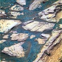
Now that I'm getting caught up with the recent imagery, I'd like to share an image of part of the Ringtail outcrop in the Meridiani Onlap/Cape York, an L257 taken on Sol-3317. Nice colors, nice sedimentary structure-- our old friends, the Fine Laminations and Burple Strata.
--Bill
|
Posted by: Phil Stooke Jun 7 2013, 05:17 PM
OK.. last question touched on Lunokhod 2. Steve was non-committal in his answer. Let me point interested parties to this Russian presentation from last year:
http://meetingorganizer.copernicus.org/EPSC2012/EPSC2012-464.pdf
In it you may find a surprise. A much longer distance, 42 km. And I can say that the more refined answer now is thought to be 42.1 km.
Why is this? The old value was based purely on engineering data, wheel turns and drive times etc. There was no chance to compare locations after each drive as we do now for Opportunity and Curiosity, because the available orbital imagery was inadequate. The engineering data are good for short drives but drift away from the correct value quite rapidly because of wheel slip and maybe sensor errors. Now we can check the actual distance using LRO images of tracks, and that's what the people at the mapping lab at MIIGAiK in Moscow are doing. They are not quite finished because they don't yet have high resolution DEMs for the whole traverse.
The old value was quite short, 5 km shorter than the new value. I think it is because they assumed a lot more slip than actually experienced, but it might also be a sensor problem. For Lunokhod 1 the new drive distance from LRO track mapping is 9.5 km, shorter than the old estimate - so you can see it's not very straightforward.
This is not really unique to Lunokhod 2. See this paper:
http://www-robotics.jpl.nasa.gov/publications/Mark_Maimone/05pers_mer.pdf
or this one:
http://www.lsgi.polyu.edu.hk/staff/Bo.Wu/publications/li&wu08_jgr_characterization_of_traverse_slippage.pdf
MER also has its issues with this, but we can fix the problem with the method called Bundle Adjustment in that paper. The Lunokhod team could not. Final result of all this - we have quite a way to go before we can be confident of beating that old record.
Phil
Posted by: Bill Harris Jun 7 2013, 07:35 PM
And then the actual ground distance traveled may be greater than the simple map distance due to the effect of rolling over the topography. Complex situation.
--Bill
Posted by: climber Jun 7 2013, 09:26 PM
Complex and interesting since, just for the record, a Marathon is 42195m. Don't tell me that Lunokhod 2 stopped 95m short to complete the task! Serriously, you're right, we have to wait to exceed and be sure.
Posted by: Bill Harris Jun 8 2013, 03:27 AM
Going through archives and looking at images of the Meridiani Onlap during the approach of Cape York around Sols-2676-2681 I came across this: a Navcam pano with 3x vertical exaggeration taken from the Meridiani Onlap on Sol-2679 showing Cape York on the left, Odyssey Crater in the center with Cape Tribulation above center on the right and Sutherland Point/Knobby's Head in the area just below right center.
It's deja'vu all over again...
--Bill
Note-- updated the attached image to a "slightly improved", wider version.
|
|
Posted by: ElkGroveDan Jun 8 2013, 04:31 AM
That is such a killer image on so many levels.
Posted by: Phil Stooke Jun 8 2013, 04:34 AM
It even makes me feel seasick!
Phil
Posted by: Explorer1 Jun 8 2013, 04:59 AM
Takes me back to the old Spirit route map days, with the valley between Husband and McCool hills, and Home Plate....
Posted by: Bill Harris Jun 8 2013, 11:09 AM
It gives me a touch of vertigo seeing and thinking about the Central Mound and the Eastern Rim of Endeavour off in the distance behind Cape York... 
Ideally, it would be nice to have a similar treatment of a similar Pancam panorama, but in reality Oppy was zipping along on the fast-track to get to Cape York ASAP, so I'm thinking that this Navcam sequence will be all we've got. 
Aye, It reminds me of the heady days of Sputnik and Gagarin when the world trembled at the sound of our (rovers)... 
--Bill
Note-- updated the attached image in Post#131 to a "slightly improved", wider version.
Posted by: fredk Jun 8 2013, 06:47 PM
In case anyone's confused by the recent http://www.nasa.gov/mission_pages/mer/multimedia/pia17078.html that shows the sol 3325 view towards Solander and Tribulation, they've mislabelled those two features. Solander and Tribulation (and Byron behind it) are very closely aligned now, as you can see from this orbital view:

|
The area labelled "multiple rock strata" and "bench" in the press image is Solander, and the area labelled "Solander" is actually Tribulation. The area labelled "Tribulation" is actually Cape Dromedary, much farther away.
Posted by: mhoward Jun 8 2013, 07:15 PM
Interesting. That did puzzle me, but I think you're right.
Adding: Earlier I did this ID of Solander Point, which I think matches up with what you've labelled. (When they posted that slide, I figured I'd got it wrong again.)
http://www.flickr.com/photos/marscat/8960884717/
http://www.flickr.com/photos/marscat/8960884717/ on Flickr
Posted by: Phil Stooke Jun 8 2013, 08:29 PM
Yes indeed, Fredk is right.
Phil
Posted by: Bill Harris Jun 8 2013, 09:19 PM
I don't think it was an error as much as it was sloppy graphics-- the annotations were in their correct locations, they just needed arrows drawn down to the hills.
I've always looked at Tribulation as "that big hill over thar" and Solander as "them foothills"...
--Bill
Posted by: fredk Jun 8 2013, 10:07 PM
But the caption says
Mistakes happen - no big deal.
Posted by: Bill Harris Jun 8 2013, 11:02 PM
Well, I guess the caption does shred their cred...
--Bill
Posted by: mhoward Jun 9 2013, 03:27 AM
I just noticed all the frames of "Esperance" post-RAT on Opportunity sol 3308 are down. Here's the stretched L456. Beautiful.

|
Posted by: Phil Stooke Jun 9 2013, 03:49 AM
That is beautiful. What a gallery of rocks we could put together now!
Phil
Posted by: CosmicRocker Jun 9 2013, 04:51 AM
I haven't seen as much of the purple-hued sediment as I thought we would around the Capes. When we first saw the stuff I thought it had to be some form of mineralization or diagenesis. Eventually I came across a paper that suggested a correlation between the purple hue and hydrated sulfates. I think that conclusion was based on a "hydration index" calculated with the pancam near infrared filters. If anyone recalls which paper that was I'd appreciate a reminder, as I can't seem to find it in my collection of pdfs.
By the way, where did we first see the purple hues in the Burns formation? I was thinking it was somewhere around Erebus Crater.
Posted by: Bill Harris Jun 9 2013, 10:08 AM
I'm think of the "Burple Rocks" being associated with Santa Maria Crater (Sol 2450-2546) and consequently the lower units of the Burns Fm, as was that Brown-Toned rock type, and others. I think of Erebus as being more about the Festooned Beds and the Weathering Rinds on rock surfaces. Or so my creaky memory sez.
I've been going through and organizing the images better and categorize everything in a searchable relational database. Been putting this Herculean task off for years, though I do have the work on some some sites started. But now that I've "discovered" Midnight Planets ( http://www.midnightplanets.com/index.html ), it will make this organizationizing (is that a word??) much easier. Thanks, Mike Howard!!!!
Currently, I'm focused on the "Meridiani Onlap", that critical contact between the Meridiani Burns Formation and the earlier weathered Endeavour ejecta apron. We have many images of that zone from the Cape York approach and many from the Cape York exit.
So much to do, so little time.
Thanks for the Espernace RAT images, Mike. I've been waiting on images to come dribbling in on that area (the usual post-conjunction logjam). Time to move _that_ off'n the back burner, too...
BTW, in the data pipeline today (?) we have a series of MIs of the soil at Knobby's Head and Pancams of a new site named "Gnarlaroo". On my Wish List at this site? Those dunes on the eastern side of the Knobby Bench... an opportunity to sample wind-transported material from inside Endeavour Crater. Both the light-toned longitudinal dunes and the dark-toned pre-barchans.
Stay tuned...
--Bill
Posted by: Ant103 Jun 9 2013, 11:06 AM
On the road North to Nobbys Head (Sol 3330)
http://www.db-prods.net/marsroversimages/Opportunity/2013/Sol3330_pano.jpg
http://www.db-prods.net/marsroversimages/Opportunity/2013/Sol3330_pancam.jpg
(Tosol we are Sol 3333, all the same numbers )
Posted by: mhoward Jun 9 2013, 01:01 PM
Don't tell anyone (just kidding), but in a few weeks I should have processed calibrated images from the PDS, plus MER-A. I still have to reduce the images to 8-bit JPGs for my purposes, so they won't be suitable for science, but it makes for much better browsing. Slow progress.
Posted by: Bill Harris Jun 9 2013, 01:32 PM
This is what our Intrepid Explorer is up to:
First is a crop of the HiRISE image ESP_018701_1775_RED.JP2 showing the northern part of Knobby's Head. It is inverted so that South is up so that it can be viewed in context with the next Pancam pan. The "*" shows the guesstimated location of Oppy on Sol-3330 and the arrow shows the approximate look direction. Those tasty dunes I mentioned earlier are in the upper left of this image, but I'll s'pose that the drive direction will be towards upper right.
And next is a panorama of the leftmost two images of the Pancam "next-drive" image set, cropped and exaggerated 3x. View is to the Southwest.
And so it goes...
--Bill

|

|
Posted by: Ant103 Jun 9 2013, 01:48 PM
Back a few sols, on Sol 3308, Oppy has imaged her tracks in color :
http://www.db-prods.net/marsroversimages/Opportunity/2013/Sol3308_pancam2.jpg
Posted by: Bill Harris Jun 9 2013, 07:11 PM
Initial impression: angular fragments, composed of angular clasts, in a (basaltic) sandy soil.
http://www.midnightplanets.com/web/MERB/image/03332/1M423993937EFFC0%23%23P2935M2M1.html(Sol-3332)
At this site: http://www.midnightplanets.com/web/MERB/image/03330/1F423810151EFFC0%23%23P1214L0M1.html (Sol-3330 FHazCam, pre-IDD deployment) and http://www.midnightplanets.com/web/MERB/image/03330/1F423813058EFFC0%23%23P1291L0M1.html (Sol-3330 FHazCam, post-IDD deployment).
--Bill
Posted by: CosmicRocker Jun 10 2013, 03:32 AM
It took quite a bit of digging around, but I think I found an image of one of the first rocks of the Burns formation with a purple hue that I noticed. It goes back to sol 657. Take a look at the attachment in http://www.unmannedspaceflight.com/index.php?s=&showtopic=1744&view=findpost&p=29691.
Posted by: Bill Harris Jun 10 2013, 07:35 AM
Sol-657, Dec 2005, has it been that long? And that Mogollon Thread, as well as the Mogollon and Olympia and Payson, et al, sites are well worth a read, well worth the review.
And I'll note that the "attached image" is by MMB. Thanks, Mike, again.
I got a chuckle. One response to your post was "Here we are, kneeling on this wonderful outcrop, can't find the handlens or scratch plate, and the carpal tunnel is acting up... ain't life wonderful", and the author of that reply didn't have corrective surgery until 2012.
Check MMB/MP. Another installment of imagery-- looks like Oppy is on the move, and going on the West side of the rim outcrop at Knobby.
--Bill
Posted by: ngunn Jun 10 2013, 08:13 AM
Talk of purple layers in sandstone has triggered a childhood memory. Digging through the white sands of beaches in the west highlands of Scotland I used to encounter discrete purple layers. Somebody told me at the time these were due to staining by iodine from the seaweed. Thinking back I would have to question this and consider the alternative possibility of gravitational sorting of haematite grains by wave action. On Mars the processes must be totally different but the same colour raises the same questions. Iodine, haematite or something else altogether?
Posted by: ElkGroveDan Jun 10 2013, 03:25 PM
Ancient Roman shipwrecks offshore with slowly leaking wine jars.
Posted by: ngunn Jun 10 2013, 04:10 PM
Maybe not Romans but Phoenicians . .
Posted by: fredk Jun 10 2013, 11:13 PM
We're getting our first good pancam views of the far rim in a while, as part of the long-baseline Nobby sequence. Here's a spectacular view that shouted out "anaglyph me!":
|

|
Posted by: Bill Harris Jun 11 2013, 02:37 AM
Here are two L257 Pamcam images from panoramas made on Sol-3325 at Sutherland Point.
The first is titled "Sutherland contact" and the second is titled "Sutherland outcrop". Both sites have intriguing lithologies and textures.
--Bill
|
|
Posted by: Ant103 Jun 11 2013, 04:46 PM
Sol 3333 panoramics are down
http://www.db-prods.net/marsroversimages/Opportunity/2013/Sol3333_pano.jpg
http://www.db-prods.net/marsroversimages/Opportunity/2013/Sol3333_pancam.jpg
Posted by: walfy Jun 11 2013, 10:31 PM
Very cool to be roving again! A nice 3D pano to be had from Sol 3334:
|
|
(Full-res at http://i.imgbox.com/adyPwIWF.jpg)
Posted by: walfy Jun 11 2013, 11:14 PM
...and beautifully layered structures from Sol 3317:
|
Posted by: Bill Harris Jun 11 2013, 11:31 PM
Here is another "Vertical Exaggeration" panorama (aka "Philovision") of the Navcam pan from Sol-3333. The Central Mound of Endeavour is on the left, Cape Tribulatin in center with the summit of Knobbys Head on the right. You can still orient via the inverted HiRISE image in my post #148.
Interesting oblique view of the downhill wasting process here.
--Bill

|
Posted by: Phil Stooke Jun 12 2013, 12:57 AM
Very nice! And here is a reduced-scale version of it with an arrow pointing to a possible new dust devil. That white streak seems to be missing in older images.
Phil

|
Posted by: Bill Harris Jun 12 2013, 02:32 AM
Indeed, the DD does show better in the vertically exaggerated image. It was fairly broad and diffuse and doesn't stand out in the "raw" image. I wonder if this is a new undocumented feature of Philovision or if it is something that we (or some of us) just forgot about?
Anyways, good catch...
--Bill
Posted by: fredk Jun 12 2013, 03:12 AM
Seriously, I don't recall it making it easier to discover DDs. But it does seem to turn a gusty thing into a DD-like thing.
Posted by: Bill Harris Jun 12 2013, 02:41 PM
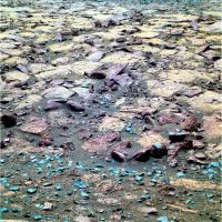
On this post-Cape_York leg of the Traverse there is a program called the "color clast survey", which appears to be an extension of the (apparently) defunct "systematic foreground..." program. This is really a good idea to characterize of the soil along the Traverse route. But they need to make sure that parts of the Rover chassis do not reflect into the camera because this can wreak havoc with the Auto-exposure and make processing the image challenging.
--Bill

|
Posted by: Phil Stooke Jun 12 2013, 03:22 PM
"it does seem to turn a gusty thing into a DD-like thing."
Maybe you're right - it should be thought of as a little puff of dust raised by the wind rather than an actual dust devil, and the stretched image would be misleading. After all, that technique would make ground cover look like a forest (or the Viking 2 site look like a Christmas tree farm).
As for documentation, I never read it so I'm not going to start writing it!
Phil
Posted by: mhoward Jun 12 2013, 03:23 PM
I think this is only a problem with the stretched JPGs from the web; I don't think it generally affects the PDS data, although I could be wrong.
Posted by: Bill Harris Jun 12 2013, 03:52 PM
May well be, but I'm thinking it'll affect the the total exposure of the frame. We'll see what it looks like in 6 mos when it hits PDS...
--Bill

|
Posted by: Phil Stooke Jun 12 2013, 04:08 PM
Yikes, it's like the fountains at Versailles!
Phil
Posted by: ElkGroveDan Jun 12 2013, 04:45 PM
The @n0m@lists would have a field day with those.
Posted by: Bill Harris Jun 12 2013, 08:21 PM
I've gone through my archives and it seems that in 2005 when we first started noticing Dust Devils at the the Spirit/Gusev site we did a lot of vertical exaggerations and animated GIF sequences. I note that many times the DDs are present as the broad, diffuse gusty areas, especially when developing and as they fall apart. And the vertical exaggeration and contrast enhancement technique would help to bring out thew DDs on these distant images of the Endeavour Central Mound (which is about as good a situation for DD hunting as the Spirit On A Hill scenario that we used before). It is not hard to do a Crop/Resize/Contrast-Tweak on incoming images of the Central Mound.
--Bill
Posted by: serpens Jun 13 2013, 12:32 AM
Dust devils? Cool, but possiby a touch passé. The probable gypsum veins in this remnant of the rim are more interesting. The rim has overrun by plains material, which means that there was massive erosion of the NW edge of Endeavour prior to that event. But was the gypsum formed within the rim which implies that these veins predate the plains material deposition and associated liquid water. Or are they the product of the same water event that is evidenced by Opportunity's observations of the plains material? I find it a touch disappointing that there seems to have been little correlation (at least in published articles) between Opportunity's limited area investigations and Endeavour crater as a whole. The hematite signature of the internal mound raises a lot of questions about how there was sufficient groundwater to form berries (assuming they are the hematite source in that area) unless the crater were filled with water.
Posted by: walfy Jun 13 2013, 05:51 AM
Wonderful shot of Nobby's Head on Sol 3335, with our goal in the distance:
|
|
(http://imgbox.com/gallery/edit/NC6Y3uLzck/gcYGQ7rvHFSJ6YFS)
Posted by: Ant103 Jun 13 2013, 10:26 AM
Yes Walfy. So much imagery this sol
A color portion of a bigger panorama, I think :
http://www.db-prods.net/marsroversimages/Opportunity/2013/Sol3335_pancam3.jpg
The bigger panorama, in greyscale for now :
http://www.db-prods.net/marsroversimages/Opportunity/2013/Sol3335_pancam2.jpg
The navcam shot, after a quick drive. Lovely ripples there :
http://www.db-prods.net/marsroversimages/Opportunity/2013/Sol3335_pano.jpg
And the drive direction :
http://www.db-prods.net/marsroversimages/Opportunity/2013/Sol3335_pancam.jpg
Posted by: Tesheiner Jun 13 2013, 11:09 AM
If I'm reading correctly, two 6x1 colour mosaics were shot on sol 3335. This is the second one, taken (almost) at the end-of-drive. The first one is still on the downlink queue and was shot before the drive, 35m to the NE.
Posted by: Bill Harris Jun 13 2013, 02:28 PM
There are so many clues and questions at this line of outcrops. We got started on understanding the basics of the history of this area with the work at Cape York and we need to be following up and tying many things together as we walk this outcrop.
For example, what is the story behind the contact and outcrop at Sutherland Point? http://www.unmannedspaceflight.com/index.php?showtopic=7646&view=findpost&p=200875 What is the lithology and nature of the several rock types seen at that site? No need to do detailed APXS or MI studies, simple Pancam Systematic Foreground or Color Clast Survey images will speak volumes. At Knobby Head, what are the similarities and differences in the (apparent) Impactite seen at CY and here? (Attached image)
Admittedly, there are time constraints in getting to Cape Trib, but it is good field practice to connect the dots was we go. On the dipping strata present here, the more deeply eroded the outcrop is and the lower in the section we can look. And this doesn't even touch on the importance of understanding the Meridiani Onlap (ie, the contact between the Endeavour strata and the post-Endeavour strata). Or the enigma of the gypsum-filled fractures that are prevalent here.
So much to do, so little time...
--Bill

|
Posted by: Ant103 Jun 14 2013, 09:50 AM
Sol 3335, wider Navcam panorama :
http://www.db-prods.net/marsroversimages/Opportunity/2013/Sol3335_pano2.jpg
Posted by: ngunn Jun 14 2013, 09:53 PM
I have a question about 'contouring'. Walking in the hills it's not uncommon to follow a contour to avoid losing height. How much does this come into play in rover operations? I note that we have gone round the top side of Nobby's Head and so kept on the level.
Posted by: fredk Jun 15 2013, 12:04 AM
The slopes are pretty subtle here and I think they could have done a direct route if they chose to. I think the approach to Nobby is mainly to do stereo imaging in case they need to use it for winter.
Also, they talked about possibly driving around and approaching from the west side of Solander, which would be easier than driving up from the east or north.
Posted by: Bill Harris Jun 15 2013, 03:45 AM
Hot off the wire... the central portion of an L257 Pancam panorama of Nobbys Head on Sol-3335:
--Bill

|
Posted by: Phil Stooke Jun 16 2013, 02:08 PM
On the road again:
http://www.midnightplanets.com/web/MERB/image/03339/1F424617048EFFC1SDP1205R0M1.html
Phil
Posted by: Bill Harris Jun 16 2013, 10:39 PM
This is also a good hint:
03339 p1211.03 2 0 0 2 0 4 ultimate_front_haz_1_bpp_pri_15
03339 p1301.06 2 0 0 2 0 4 rear_haz_penultimate_1bpp_pri17
03339 p1311.07 2 0 0 2 0 4 rear_haz_ultimate_1_bpp_crit15
03339 p2388.32 10 0 0 3 2 15 pancam_drive_direction_5x1_L2R2
http://merweb.sese.asu.edu/merweb.pl
--Bill
Posted by: walfy Jun 17 2013, 06:08 AM
A 3D pano from Sol 3339. Looks like we're south of Nobby's Head already, and rough plains ahead!
Solander Point is already showing a touch of parallax! Or am I imagining things.  Viewable in http://imgbox.com/adfQ2Qy7.
Here's a smaller version:
|
|
(http://imgbox.com/adfQ2Qy7)
Posted by: fredk Jun 17 2013, 02:17 PM
Thanks for the nice stereo pan, walfy. I think we'd have to be almost sitting on top of Solander before we could see parallax with pancam...
Posted by: Ant103 Jun 17 2013, 07:28 PM
Navcam and Pancam for this Sol 3339 :
http://www.db-prods.net/marsroversimages/Opportunity/2013/Sol3339_pano.jpg
http://www.db-prods.net/marsroversimages/Opportunity/2013/Sol3339_pancam.jpg
Nothing seems to be between us and Solander Point now
Posted by: fredk Jun 17 2013, 08:02 PM
I'm going to propose that this old degrated crater:

|
is visible as this wide, smooth patch:

|
The direction and angular extent match well what we'd expect from the 3339 location.
Posted by: Phil Stooke Jun 17 2013, 08:49 PM
Looks like you're right. I guess we will skirt the edge of it.
Phil
Posted by: walfy Jun 18 2013, 10:11 PM
This shot renders nicely in 3D, thought I'd share it, overlooking the swale atop Nobby's Head, Sol 3339 still:

|
It's always mind-blowing to look down the inner slope of this great Martian crater, especially with features in the foreground. Makes me feel like I'm there!
Posted by: Tesheiner Jun 19 2013, 10:13 AM
Here's a navcam mosaic taken at the current site. It was shot during sol 3342 after driving about 54m SSE from the previous position.

|
Posted by: MichaelT Jun 19 2013, 03:37 PM
Nature has an interesting story on the distance travelled by Lunokhod 1 and 2 on the Moon.
The scientists from MIIGAiK in Moscow now seem to have finished their analysis using DEM data (see earlier in the thread).
Lunokhod 1: 9.93 km (instead of 10.54 as recorded in the logs)
Lonokhod 2: 42.1 to 42.2 km (instead of 37 km as recorded in the logs)
http://www.nature.com/news/space-rovers-in-record-race-1.13229
So it really seems that Oppy is still quite a long way from breaking the distance record...
Michael
Posted by: Bill Harris Jun 19 2013, 04:23 PM
Here is a parting shot of Nobby's Head by Oppy on Sol-3442. A 2x1 Navcam panorama, 3x vertical exaggeration, looking back to the North.
--Bill
Added: Here is a HiRISE image of the site, with the approximate Sol-3442 location of Oppy shown along with the sight margins of the above Navcam pano.

|

|
Posted by: James Sorenson Jun 20 2013, 02:50 AM
Just something I put together
http://www.flickr.com/photos/43581439@N08/9088077807/
Posted by: Bill Harris Jun 20 2013, 04:09 AM
An L257 Pancam of the site "Numbat", Sol-3342, presumably located on the Bench at Nobby's Head. Along with the corresponding R721 Pancam, there is the suggestion of a change in composition of the underlying soil unit.
--Bill

|
Posted by: Phil Stooke Jun 20 2013, 01:30 PM
Sol 3343 - looks like we just turned east for a short drive up to the southernmost hill of Nobby's Head.
Phil
Posted by: Tesheiner Jun 20 2013, 04:16 PM
If I'm reading the data correctly, Phil, there was no drive on 3343 but there's one planned for 3344.
Posted by: Phil Stooke Jun 20 2013, 04:35 PM
Oh... OK... I was looking at this 3343 image and thinking it had to be where my lines show it here.
Phil
|
Posted by: Bill Harris Jun 20 2013, 05:52 PM
Tis possible-- you;re thinking that the light-toned fragments to the South (Navcam) are that low hill to the South (HiRISE)? The relief is so subdued here it's hard to tell. We have a Navcam Albedo pan on the table (with one bad frame), that would be ideal to polar project for Location. Expecting that last image just anytime...
--Bill
Posted by: Tesheiner Jun 20 2013, 05:56 PM
Perfect matching. And I think the same features are visible on the http://www.unmannedspaceflight.com/index.php?s=&showtopic=7646&view=findpost&p=201049.
PS: Can't update the route map until the weekend. I'm travelling.
Posted by: mhoward Jun 20 2013, 07:01 PM
I think your position is correct too, Phil. The drive direction images on sol 3342 were facing east, so perhaps she's not done photographing Nobby's Head. Here's an anaglyph view.

|
Posted by: Phil Stooke Jun 21 2013, 12:01 AM
This is half of a circular pan from sol 3339. The low hills where we are at present (3342) are visible to the southeast of this location.
Phil
|
Posted by: Bill Harris Jun 21 2013, 12:02 AM
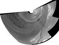
The "missing piece" of the Albedo Pan hasn;t arrived so I did a quick cylindrical pan and reprojected it as a Polar pan.
Sol-3342, p2297, L2 Albedo Pan. North approx up:
--Bill
|
Posted by: Bill Harris Jun 21 2013, 12:29 PM
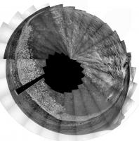
Practicing a bit with polars, here is a 3x1 Navcam from Sol-3442. North approximately up.
And we have several interesting Pancam sequences in the pipeline...
--Bill
|
Posted by: Bill Harris Jun 22 2013, 10:03 AM
My best "TLAR" guesstimate of where Oppy is on Sol-3345:
--Bill
|
Posted by: Tesheiner Jun 22 2013, 10:29 AM
I think the last two sites, 3342 and 3344, are slightly south of those positions. Here're the two vertical projections I just made to update my route map.
|
|
Posted by: Bill Harris Jun 22 2013, 03:03 PM

It's not as prominent as it looks from HiRISE-- some of the deceptive relief may be emphasized by albedo features.
The L257...Pancam sequences are still on the way, the L2/R2 stereo pairs are starting their way down.
Berrio_Crater_2x1_L257R2 Sol-3044
Berrio_bench_L257R2 "
Carlindi_half_L257R2 "
Numbat_L257R12467 Sol-3344
Hornby_L257R2 "
Mulga_L257R12467 "
Chameleon_L257R2 "
Jacky_L257R12467 "
The current site is that "updip, low in the sequence" area we were hoping for. Oh joy!
--Bill
Posted by: Ant103 Jun 22 2013, 03:34 PM
My take on this Sol 2244 & 2245 full 360 Navcam pan
http://www.db-prods.net/marsroversimages/Opportunity/2013/Sol3344_pano.jpg
Posted by: Phil Stooke Jun 22 2013, 04:23 PM
Nice pan - here's my circular version. Let's see if we can locate those names on it. (we had a Numbat 2 sols ago, and a Berrio crater near Whim Creek... seems a bit odd)
Phil
|
Posted by: Bill Harris Jun 22 2013, 05:20 PM
Right. The "Berrio Crater" (and -Bench) were Sol-3044. Those hid nicely in the Sol-3344 image list...
--Bill
Posted by: Tesheiner Jun 22 2013, 05:26 PM
They were shot on the same sol but at the previous site, the one from sols 3342-3344 with ID "C200". Most, if not all of them, are on http://qt.exploratorium.edu/mars/opportunity/pancam/2013-06-22/.
Posted by: Bill Harris Jun 23 2013, 03:50 AM
It's not that bad. There are some 20 post-Esperance named sites and of these 8-9 are the current crop. The problem is keeping up with things in the long run.
--Bill
Posted by: Phil Stooke Jun 23 2013, 12:26 PM
Wowsers! Looks like we're down on the plains again:
http://www.midnightplanets.com/web/MERB/image/03346/1N425235632EFFC2LMP0703L0M1.html
Phil
Posted by: Bill Harris Jun 23 2013, 12:26 PM
Looks like she's folded her tent and is headed Southwardish.
And we never found out about Gibber_Earless...
--Bill
Posted by: Phil Stooke Jun 23 2013, 12:51 PM
"There are some 20 post-Esperance named sites and of these 8-9 are the current crop. The problem is keeping up with things in the long run."
That's what I am trying to do, to record, maybe not all these names, but as many as is feasible, and locate them on maps. Earlier ones come out of the Analyst's Notebook, but I try to keep up with current ones as well. But it's a lot of work!
Phil
Posted by: Bill Harris Jun 23 2013, 02:03 PM
It is a lot of work. Not only the identifying the named sites, but also locating them on polar reprojections of Nav- and PanCam panoramas (if available) and thence to HiRISE images and HiRISE-derived maps. As you well know. The BIG problem is not so much the named sites, but the multitude of "Foreground Quarter" and "Clast Survey"and "one-shot drive-by" images. Even innocuous images like FHazCam and RHazCam shots are useful for soil texture info.
It never ends. Thank goodness...
--Bill
Posted by: Bill Harris Jun 23 2013, 10:17 PM
Here is a best guesstimate of where Oppy was on Sols-3342-3344-3346:
The graben-- fault block-- that she passed East of on exiting Nobbys Head bench may show up on the azimuth 270* partial Navcam pan.
--Bill

|
Posted by: Bill Harris Jun 24 2013, 04:22 AM
Here is a 5x1 pano of that Sol-3346 Navcam sequence with a cropped and rotated portion of the above location image, showing the suspected graben/fault block. Note especially the unusual textures of the weathered rock in the "fault plane".
--Bill
Added: A 4x1 pano of the above sequence (left the fifth "northmost" panel off) showing the suspected fault (but not as well as I'd hoped).
--b

|

|
Posted by: Ant103 Jun 24 2013, 09:49 AM
Sol 3346 panoramics :
http://www.db-prods.net/marsroversimages/Opportunity/2013/Sol3346_pancam.jpg
http://www.db-prods.net/marsroversimages/Opportunity/2013/Sol3346_pano.jpg
Posted by: Bill Harris Jun 24 2013, 02:07 PM
Now these sites are going to be interesting:
Gibber Earless
http://www.midnightplanets.com/web/MERB/image/03346/1P425226706ESFC2B3P2597R2M1.html
Signal Head
http://www.midnightplanets.com/web/MERB/image/03346/1P425226858EFFC2B3P2391R2M1.html
Got stereo pairs, waiting for the color imagery.
--Bill
Posted by: Tesheiner Jun 24 2013, 03:54 PM
Love it! And the view will improve drive after drive.
Posted by: Phil Stooke Jun 24 2013, 04:47 PM
This is a cleaned-up view of Solander Point (and Cape Tribulation peeking over its shoulder) - cleaned up by merging the two most recent pancam images to improve signal to noise (mostly JPEG artifacts). There should be plenty of interesting things to look at - I like the long continuous light-toned stratum at the top of the brighter area. (Hopefully it's not just a big dust drift!)
EDIT - see following post - Bill's right of course - looks like the Meridiani plains, AKA Burns Formation, slope upwards a bit where they are plastered onto the tip of the point. But we presumably have to go higher up to get the slopes we need plus the old Endeavour rim material.
Phil
|
|
Posted by: Bill Harris Jun 24 2013, 07:42 PM
The bright area is the usual Meridiani Overlap/Bench that crops up at the foot of the hills and the continuous stratum may be simply outcrops superimposed along the line of sight. Here is a cropped and inverted ("North" is down) HiRISE image of the target area:
--Bill

|
Posted by: ngunn Jun 24 2013, 08:32 PM
It's very nice to have the view ahead and the view from overhead consecutively in the last two posts. Even better would be if someone could identify a few key points in both images to help the rest of us get our bearings. I have to admit I'm struggling a bit to find sure identifications when it comes to the details.
Posted by: Bill Harris Jun 24 2013, 10:39 PM
Good idea. It's hard to tell "Who's on First or What's on Second" without a scorecard.
First: An annotated and clarified image from Arvidson, et al.
Second: Phil's "solander_cleaned" image and a HiRISE image, shamelessly annotated.
"HTH"
--Bill

|

|
Posted by: vikingmars Jun 25 2013, 09:48 AM
What an interesting geological site ! I hope they will have some time left to climb a little, even up to Solander Point if they can...
The view from up there on the crater and surrounding plains should be gorgeous ! Maybe that the rim of Bopolu crater on the south-west will be also visible from this new vantage point

|
Bopolu Crater, as seen by Opportunity, Sol 2195
Posted by: mhoward Jun 25 2013, 08:44 PM
Special treat today: at least part of the sol 3348 drive direction mosaic is in stereo color (L27R12).

|
Posted by: Phil Stooke Jun 25 2013, 08:54 PM
And the big filled crater is smiling benignly down on us as we go by.
Phil

|
Posted by: ngunn Jun 25 2013, 10:48 PM
"Hello and goodbye. I missed the chance to swallow you but never mind."
Posted by: Bill Harris Jun 27 2013, 02:05 PM
Here is a registered and merged combination of the L2 and R2 Drive Direction images from Sol-3350. This shows the Eastern slope of Solander in the vicinity of the "Bluffs" that I identified earlier in Post#223. In the foreground is the light-toned, and blocky, Meridiani Onlap unit. Above it can be seen distinct layers and even ledges of the basal part of the Endeavour Rim unit. This low part of the section has a good chance of having been weathered under wet and warm conditions (say "clay").
Don't zoom in beyond 150%, I didn't do a lot of work here prettyfying it...
--Bill

|
Posted by: fredk Jun 27 2013, 05:34 PM
...Phil's "solander_cleaned" image and a HiRISE image, shamelessly annotated.
I think your rightmost arrow points to a feature on Tribulation - check out my old ID http://www.unmannedspaceflight.com/index.php?s=&showtopic=6897&view=findpost&p=176029
Posted by: RoverDriver Jun 27 2013, 06:41 PM
That was my request. Red gives more contrast while Blue has sharper images. I wanted to see if Blue would give us more range data, or better range data farther from the rover to be able to extend our drives. The outcome is that yes, Blue gives range data at a larger distances but it is quite noisy so we have sparser data.
Paolo
Posted by: mhoward Jun 27 2013, 07:09 PM
Very interesting. Is there any way you could combine red and blue? I ask for purely selfish reasons, because false-color drive direction stereo pairs are pretty much my favorite thing ever
Posted by: RoverDriver Jun 27 2013, 08:47 PM
Likely yes but now with a shoestring budget any development is tough to justify. Whenever we can we use both when we assess the terrain in front of us but manually, there is no automation behind it.
Paolo
Posted by: serpens Jun 27 2013, 11:02 PM
Bill, post 228. It sure looks like strata but we have been fooled by Endeavour many times and Solander is almost certainly as big a dog's breakfast as Cape York. I think we are still in a 'suck it and see scenario'.
Posted by: Bill Harris Jun 27 2013, 11:22 PM
May well be Pareidolia in action. There are so many wild-eroded flutes on that surface that they may be looking like lineations at this low viewing angle.
We'll see what we see when we see it...
--Bill
Posted by: Bill Harris Jun 28 2013, 01:52 AM
Posted by: mhoward Jun 28 2013, 03:09 PM
According to metadata, Opportunity drove almost 120m south on sol 3351. Nice!
Posted by: neorobo Jun 28 2013, 03:44 PM
Nice email sent to the Opportunity team from John Callas after the Sol 3348 drive.
Over ten years ago, we struggled over whether the mission success distance requirement for the Mars Exploration Rovers should be 500 meters or 600 meters. The more ambitious requirement of 600 meters was chosen. When we landed, we fantasized how wonderful it would have been to have had multi-kilometer capability to reach the Columbia Hills with Spirit, knowing the rovers were designed for only 1 kilometer. We reached the Columbia Hills. After exploring Endurance Crater with Opportunity we ventured to imagine getting to Victoria Crater, requiring more than 10 kilometers of odometry. We reached Victoria. The problem with dreams is that when you achieve them you have even grander ones. We dreamt of now doubling Opportunity's odometry to reach the more ambitious target of Endeavour Crater. We fulfilled that dream. As ever more ambitious targets were achieved we set our sights on establishing the off-earth driving record. That record is held by the Soviet Lunokhod-2 rover from 1973. For four decades that record was 37 kilometers. Recently, with image survey data from the Lunar Reconnaissance Orbiter (LRO), the Lunokhod record is estimated to be father still. Whatever that record is, we know we are closing in on it. Today, with the Sol 3348 drive of nearly 100 meters, Opportunity's odometry is now 37,028.11 meters, exceeding 37 kilometers ! Clearly this rover and mission are in the Pantheon of great missions of exploration. These outstanding accomplishments are wholly due to your extensive contributions and unbridle dedication. Thank you for that. Well done. And, keep going!
Sincerely,
John
Posted by: Tesheiner Jun 28 2013, 07:08 PM
Definitely. And I would like to highlight his sentence "Clearly this rover and mission are in the Pantheon of great missions of exploration".
At this pace we might make "landfall" in two or three weeks.
Posted by: Bill Harris Jun 28 2013, 08:56 PM
Part of the current HiRISE image of the Oppy route between Nobbys Head and Solander suggests a set of N-S lineations that appears to be offset at a point midway between the two sites. I wonder what the nature of these lineations is? And what is the nature of the area where they are apparently offset?
Another of the Mysteries of Mars...
--Bill

|
Posted by: ngunn Jun 28 2013, 09:30 PM
Inward slumping of parts of the crater rim are evident on the far side of Endeavour crater so perhaps this is the eroded remains of something like that? The Noachian layers seem to be dipping downward into Endeavour. Was that the case before the Endeavour impact or is it a product of that impact in some way? Questions, questions . .
Posted by: serpens Jun 29 2013, 12:24 AM
Endeavour is pretty much on the threshold size for a complex crater so the eastern rim features could be where final crater marginal collapse zones caused terracing with associated faulting. The original rim would have been many hundreds of meters high so there could also have been some rebound, slumping and fracturing. The Endeavour rim is so worn down and over-run that it is difficult to determine an accurate footprint of the final crater.
Posted by: Bill Harris Jun 29 2013, 01:55 AM
What impresses me is that the Meridiani-age sediments (which we are now presumably traversing) were deposited long after the Endeavour event with the crater rim eroded down to a nubbins and the ejecta blanket eroded away or covered. The idea that the crater rim could still be structurally (tectonically??) active after all these aeons is almost incomprehensible. Not only do we have the lineations in the Meridiani-age sediments we also have that offset at the central point which implies faulting or slumping. And the term "Meridiani-age sediments" may be open to reinterpretation-- they may be the basal Burns Formation or even earlier. The gross characteristics are similar to the Burns: thinly-laminated to massive, fine-grained with concretions. We are not sure if the concretions are Blueberries, Newberries or Boysenberries.
A mystery that could be wrapped up in a enigma...
--Bill
Posted by: MarkG Jun 29 2013, 10:21 PM
Speculation: If the older buried rock along the rim has a lot of clays, expansion and contraction due to variable moisture content at some depth could generate large-scale cracking -- a periodic wetting and dessication cycle. The rock type boundaries of the rim would entrain the cracks.
Montmorillanite on Mars?
Posted by: serpens Jun 29 2013, 11:48 PM
At Endeavour we are trying to interpret events that took place roughly 4 Ga ago in a far more energetic environment. The dating is rubbery and the elapsed time between the Endeavour impact and the Meridiani sediment event is unknown. While we have come to love the traverse surface of laminated sulphate sandstone littered with hematite concretion lag can we make any correlation to the Burnes formation which is defined as the 7 odd meter stratigraphic section explored in Eagle crater and Endurance? The big crater roadcuts of Endureance, Erebus and Victoria were at the top of a mound and we have descended a fair way with limited analysis of the couple of crater roadcuts we passed on the way. The Botany Bay surface looks different, but does this reflect enhanced erosion from channelling of wind from the crater or something else entirely?
Posted by: Bill Harris Jun 30 2013, 03:44 AM
Amen, brother. The surface started to look different when we rolled off of the Cape York bench and continues to provide much amazement. I see that we are still getting the "clast survey" and the "systematic foreground" sporadically in the daily offerings but we'll need to go mine the PDS in a few months. Still, the surface is fascinating to look at as we roll along.
Here is a crop of a HiRISE RED channel image of the Western Rim of Endeavour. This is just off the possible route of Oppy and in in the general vicinity of the supposed offset of the lineations that I noted a couple of days ago. Scale is 25cm/pixel and I've added a scale bar. Take a look and see what you can see. Bear this in mind: this is a red channel image, so reddish areas will show as light-toned, and bluish (ie, basaltic or hematitic signatures) will show up as dark-toned.
Have fun...
EDIT:Oops. Got a decimal off on the scale bar-- should be 50m, not 5.0
--Bill

|
Posted by: Phil Stooke Jun 30 2013, 03:12 PM
Looks like another drive on sol 3353 - don't know how far yet, but we are covering the distance pretty fast now.
Phil
Posted by: Tesheiner Jun 30 2013, 08:25 PM
30m, according to the metadata.
Posted by: Bill Harris Jul 1 2013, 01:36 PM
I've not heard of that happening. Most likely they are related to stress-relief, but why do they cut through younger rocks and what are they more-or-less parallel to the rim structure?
At any rate, unusual rocks from the RHazcam, Sol-3553, presented in x-eyed stereo. Cut, paste and rearrange the pair as you see fit.
And, in the pipeline, a slew of MIs from Sol-3552. Yay.
--Bill

|
Posted by: serpens Jul 1 2013, 11:37 PM
Perhaps we shouldn't put too much emphasis on the orientation. There are similar features just to the east of Cape York visible in the attached image with varying orientation. As far as I know we don't have a real consensus on the cause of Anatolia Trough do we?

|
Posted by: Bill Harris Jul 2 2013, 03:40 AM
I've been admiring that terrain East of CY for years now.
The orientation and alignment of the lineations with the (remnant) structural features of the Endeavour rim is too strong to be considered casual. My intuition says that there may be a connection, but I'm always looking for another interpretation.
I don't know what current thought is on the Anatolia features. I feel that years ago the interpretation was karst: solution of the soluble keiserite-cemented sandstone along fractures and joint systems. And that is my continuing interpretation. I remember that Phil Stooke has some polar projections of MER-B Pancam panoramas of the type Anatolia feature near Eagle (Fram??) crater from the early Sols of Oppy.
Anyways, here is an annotated image of the Eagle-Endurance Crater region, with the Anatolia features delineated in Red, and the boundary between the Smooth sandy plains and the Rippled sandy plains to the South. I did this in 2005-2006 and the image is named "MER_DIMES_anatolia"; I don't recall where I got that base image.
--Bill

|
Posted by: Phil Stooke Jul 2 2013, 10:57 AM
As the file name suggests, that is one of the three images taken by the descent image camera to measure horizontal motion and allow it to be cancelled out during the final stages of descent.
Phil
Posted by: Bill Harris Jul 2 2013, 11:50 AM
Ah, "Descent Image Motion Estimation System", intuitive once it's deacronym'd. PIA05146. And now I've gotten a proper non-jpeg'd TIFF.
Hmmm, you don't suppose that the shadow in a hotspot to the left of Endurance Cr really is a hotspot and shadow???
At any rate, here is a ground-truth demo comparing a crop from the DIMES image 3 and one of the MER-B polar Pancam panoramas (although one of my source/ working images is labeled "MOC" instead of "DIMES").
You can see that there is a preferred orientation to these things, even several kilometers away.
--Bill

|
Posted by: jamescanvin Jul 2 2013, 11:59 AM
I can't quite beleve we are talking about this again nearly a decade later, but that 'hotspot' is the opposition surge with the shadow of Oppy's parachute near the centre.
Posted by: Bill Harris Jul 2 2013, 12:40 PM
The enduring legacy of MER...
I found this interesting thread:
http://www.unmannedspaceflight.com/index.php?showtopic=195&hl=dimes
--Bill
Posted by: Phil Stooke Jul 2 2013, 01:36 PM
Back to 2013! This is the current position, a comparison of HiRISE and the 3353 Navcam partial pan in circular projection. A red spot shows the current location. Since they have made such good progress, maybe there will be a brief examination of the bedrock just ahead over the upcoming holiday.
The dark streaks in HiRISE are seen in the Navcams to be dust drifts.
Phil

|
Posted by: Bill Harris Jul 2 2013, 02:04 PM
Any idea where site Tawny is located?
Posted by: Phil Stooke Jul 2 2013, 02:20 PM
No - what's it from? The latest Pancam targets?
Phil
Posted by: TheAnt Jul 2 2013, 03:17 PM
I concur, so you do not just need to feel about it my friend.
In the early part of the mission the rover did encounter several cracks that indeed were interpreted as signs underlying karst terrain, and that some now have been found to be associated with Endeavour crater could be a hint it have formed in cracks and areas where the bedrock have been shocked which gives us a bit of a timeline on the formation here. Even though the actual dating could be rather 'rubbery' indeed.
Posted by: mhoward Jul 2 2013, 03:30 PM
It's challenging to locate because the images haven't come down yet, but "Tawny" is the target that Oppy examined with the arm on Sol 3352. She briefly backed up and captured Pancam images of it on sol 3353 before moving on.
Posted by: centsworth_II Jul 2 2013, 03:45 PM
I think it's important to note that the cracks back in the pre-Victoria days are on the surface of a sedimentary stack hundreds of meters thick, while the cracks around Endeavour's rim are in a relatively thin layer of sediments covering the rim -- perhaps only a few meters thick in some spots. The near underlying rock in both cases is totally different, so the processes resulting in the cracks on the surface is likely different as well.
For example, the karst explanation may work well for the earlier terrain while the cause of the Endeavour rim cracks could more likely be the result of slumping of the underlying crater rim or differential expansion/contraction of the thin sulfate surface layer and the underlying rock of the rim.
Just my meagerly informed musings.
Posted by: MarkG Jul 2 2013, 05:28 PM
At any rate, unusual rocks from the RHazcam, Sol-3553, presented in x-eyed stereo. Cut, paste and rearrange the pair as you see fit.
And, in the pipeline, a slew of MIs from Sol-3552. Yay.
--Bill
The wetting/dessication cycle could be one in tens of thousands of years (orbital/precession cycles), and still be effective at creating "active" features in this profoundly ancient landsacpe.
Posted by: Bill Harris Jul 2 2013, 06:13 PM
Oh, agreed wholeheartedly. The Anatolia features seen early on and these lineations seen here are of the products vastly different ages, processes and Mars'es (climates). Especially intriguing is the terrain to the east within Endeavour which has many AnatoliaFeature-like characteristics but with a different genesis.
And doubly especially the thin, persistent (over a few kilometers at least) unit of the Meridiani Onlap which represents an unconformable contact between the old weathered and reworked impactites of the"Endeavour formation" and the newer sedimentary clastics of the basal Meridiani formation. This is a unique instant in geological time and we need to be looking at the ground under our boots to hear it's story...
--Bill
Posted by: Bill Harris Jul 2 2013, 06:30 PM
It's in this vicinity:
--Bill
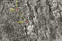
|
Posted by: Phil Stooke Jul 2 2013, 06:47 PM
At the scale of a HiRISE image Tawny can be located a bit more precisely than that, Bill! It was within reach of the arm on sol 3352, and Opportunity was driving backwards with its arm on its north side at the time, so Tawny is a pixel or two on the north side of the sol 3351 location. It's at the scale of the rover camera mapping that we don't yet know where it is
Phil
Posted by: Bill Harris Jul 2 2013, 09:51 PM
But without FHazcams w/ the IDD deployed or the Pancam sequence we won't know exactly where Tawny is.
I guess it may be in this locale
http://www.midnightplanets.com/data/MERBRawJPG/03353/1F425859620EFFC3R9P1205L0M1.JPG
and zooming in on the HiRISE image I can pick out which of several rocks it might be, but not exactly. But I'll guess when we do get a peek at it, it'll be almost earthshaking...
--Bill
Posted by: mhoward Jul 2 2013, 11:03 PM
As Phil says, "Tawny" is near the sol 3351 marker (assuming that's in the right place), facing SW from the rover. This sol 3351 Front Hazcam image should show it: http://www.midnightplanets.com/web/MERB/image/03351/1F425685490EFFC3NLP1214L0M1.html.
But I'm not sure "Tawny" was much of anything; they might just have been checking out the arm after this potentiometer issue mentioned in the http://marsrovers.jpl.nasa.gov/mission/status.html#opportunity.
The feature you're interested in (post-drive on 3353) doesn't have a name yet, that I'm aware of. (Well it might have a name that we don't know about, but you know what I mean: there are no Pancam images of it the metadata yet.)
Posted by: Bill Harris Jul 3 2013, 01:47 AM
Yes... I guess... we're just going to have to wait.

Posted by: nprev Jul 3 2013, 02:38 AM
<MOD HAT ON> Very funny, all, but let's try to stay a bit focused, eh?
The opstempo right now is a bit (well, quite a bit) more leisurely than previously. So, we're gettin' a little bored in the long intervals between new events. Understandable & natural.
Unfortunately that means that the SNR of this thread is decreasing thereby. I don't think it's intentional at all, but nevertheless it's happening.
So...just a gentle (and I do mean that) reminder to try to focus a bit more on the observations & the science. That's all.
</MOD>
Posted by: mcaplinger Jul 3 2013, 03:59 AM
I'm not sure what your point is, because this is a MER thread.
Posted by: nprev Jul 3 2013, 05:38 AM
The point is that I'm an idiot, I'm really tired (tough couple of days, in the middle of a temp schedule alteration) & screwed up. Post modified; thanks, Mike!!!
Posted by: fredk Jul 3 2013, 02:41 PM
Not totally clear what happened on 3335 - we have http://qt.exploratorium.edu/mars/opportunity/rear_hazcam/2013-07-02/1R426043435EFFC400P1311R0M1.JPG?sol3355 but no fhaz down. The latest blog entry at the end of http://www.nmnaturalhistory.org/rover-field-reports-from-mars.html says
Posted by: mhoward Jul 3 2013, 03:54 PM
That one rear hazcam must have been good though; they drove another 25m on it on sol 3356 (with autonav). That's after over 116m on sol 3355, plus taking a bunch of images along the way.
Bill and Phil: the crumbly rock on sol 3353 is now named http://en.wikipedia.org/wiki/Lake_Eyre. They got an L257R2 of it before zooming off.
The layers at the sol 3356 site (176/0158) are beautiful. Here are very quick Navcam and Pancam anaglyph views.

|

|
Posted by: Bill Harris Jul 3 2013, 04:43 PM
Yes! Lake Eyre.
And tosol's (Sol-3356) Drive Dir Pancams show the wonderfully delicate remnant bedding underfoot (-wheel). We may start seeing significant changes in the outcrops over the next few drives.
One of those Pancams in your anaglyph, for reference:
http://www.midnightplanets.com/data/MERBRawJPG/03356/1P426122443EFFC4BMP2401L2M1.JPG
--Bill
Posted by: ngunn Jul 3 2013, 08:53 PM
I like this view because it has the horizon (almost) horizontal. This is in spite of the rover being on a hillside. I presume the surface is quite bumpy and here we are luckily levelled by one of the bumps. Solander point has appeared on recent images as if it were a considerable hill, whereas like Cape York it is more like a shelf on a sloping surface. The top of it is about ten metres above plains outside the crater, useful perhaps for spotting distant horizons but not really much of a hill.
http://qt.exploratorium.edu/mars/opportunity/navcam/2013-07-03/1N426122294EFFC4BMP0702L0M1.JPG
Posted by: walfy Jul 3 2013, 08:55 PM
For what it's worth: a short traverse sequence from Sol 3356.

|
Posted by: Phil Stooke Jul 3 2013, 08:57 PM
That's great! I always like driving gifs.
Phil
Posted by: serpens Jul 3 2013, 10:21 PM
Bit of a salutary lesson there when making assumptions from orbital images. Remember the DEMS of Cape York which had it looming over the neighbourhood?
Posted by: walfy Jul 4 2013, 05:04 AM
There's some real parallax going on with with Solander Point and the distant ridge behind it, as I suspected a week or so back. It's quite clear now. We're getting so close to our winter hangout!

|
Posted by: Bill Harris Jul 4 2013, 05:28 AM
Having recently reviewed imagery of the approach to Cape York, I was reminded of the puzzlement of how low the relief of CY was from the Meridiani side. Of course this low relief was emphasized by a tricky optical illusion with the HiRISE imagery-- with the prevailing wind from the East, the Eastern side of CY tends to have the light-toned fines removed, leaving the dark-toned fragments behind, and then depositing the light-toned fines in the wind-shadow on the Western slope, thus giving a false emphasis to the apparent relief of CY.
At least Solander and Tribulation have some relief...
--Bill
Posted by: fredk Jul 4 2013, 01:34 PM
I didn't think it was possible, but you're clearly right. I estimate we're around 800-900 metres from that visible upper edge of Solander, which translates into a parallax of about 1.5 pixels at pancam L/R separation against the far background. Nice job spotting that!
Posted by: DFinfrock Jul 5 2013, 02:34 AM
A.J.S. Rayl's new Planetary Society monthly update on Oppy is online.
http://www.planetary.org/explore/space-topics/space-missions/mer-updates/2013/06-mer-update-opportunity-continues-sprint-to-solander-point.html
Posted by: Bill Harris Jul 5 2013, 02:57 AM
Here is the Sol-3355 drive direction 3x1 Pancam, cropped and reprojected in a polar format. This was cropped to show the fore- and mid-ground. It is oriented in the drive direction, with South approximately up. Note the wonderful texture of the outcrop, especially in the foreground.
--Bill

|
Posted by: SFJCody Jul 5 2013, 05:43 AM
Wow, Oppy's 10 year launch anniversary is coming up! IIRC the launch date slipped a couple of times and there were suggestions that if it was pushed forward much further it could have to wait until the '05 opportunity.
Posted by: jamescanvin Jul 5 2013, 08:16 AM
An intriguing and tantalising snippit:
Posted by: Bill Harris Jul 5 2013, 10:17 AM
Here is the Sol-3356 drive direction 3x1 Pancam, cropped and reprojected in a polar format. This was cropped to show the fore- and mid-ground. It is oriented in the drive direction, with South approximately up. Note the wonderful texture of the outcrop in the foreground and midground, and the bedding in the midground.
--Bill

|
Posted by: serpens Jul 6 2013, 12:39 AM
It would be nice to know whether Tawny was targeted or happenstance. Actually it looks kind of interesting. Rounded, sorted grains, texture reminiscent of lower Overgaard and a change from most of the laminated sedimentary surface. Pity in a way that priorities and winter deadlines have precluded any in depth investigation of the approach to Cape York or Botany Bay since a high water table at the top of the mound would imply at least some level of surface flow could have been expected in Botany Bay. Anyway, with the Solander slope hopefully Opportunity will be able to do a bit of roaming and investigation this winter.

|
Posted by: Bill Harris Jul 6 2013, 02:49 AM
The MI that came down today was not "Tawny". Today's MI is p2935 and the named site is p2530. Good sleuthing, though. And a good description of the victim.
As far as I've been able to prognosticate, this MI was taken after the FHazcam IDD check subframe made on Sol-3551 at Site-175/0589. The MI was made on Sol-3552 and is of the corner of one of the ubiquitous flatrocks of the area. This, AFAIK, was made after the IDD arm went C R E A K and they did a diagnostic on the spot.
Attached is a location image with some enhancement. This rock, which I am informally naming Ferd, was a surprise to me. It is more coarsely clastic than I would have expected. But this is a completely different area (and era) that what we have studied before, so it certainly falls within my expectations. I wish we had a better understanding of the Meridiani Onlap.
Anyway, this MI of today is the first of a series p'haps 20 MIs to look forward to.
--Bill
NOTE: Serpens was right, this site is "Tawny". Corrections and apologies made...

|
Posted by: mhoward Jul 6 2013, 03:38 AM
No - the MI and the fhaz subframe are indeed "Tawny". p2935 isn't a site code, it's a command sequence number.
(For reference, the Pancam images of Tawny were taken on sol 3353 at site 175/0591, after backing up from site 175/0589 where the arm work was done. The image ids for the Pancam images are 1P425857332ETHC3NNP2530L2M1 through 1P425857701ETHC3NNP2530R7M1; the site code is 'C3NN'; C3 = 175 and NN = 0591. This will all get much easier once the images actually come down.)
Posted by: Bill Harris Jul 6 2013, 10:25 AM
Correct, and I apologize to Brian for poo-poohing his location ID.
I have gotten into the habit (shortcut ??) of using the command sequence number (an action) to identify a location. I guess I started doing this since I use the Pancam Tracking Database to keep track of what, where and when was done. This works most of the time, but sometimes doesn't.
Ferd is now known as "Tawny".
And we do have a Phobos image upcoming:
03359 p2739.01 0 0 0 0 0 0 pancam_phobos_deimos_prepoint_L1R4
--Bill
Posted by: SFJCody Jul 6 2013, 02:00 PM
03360 p1215.03 0 0 0 0 0 0 front_hazcam_ultimate_0.5_bpp_pri_18
03360 p1234.06 0 0 0 0 0 0 front_haz_fault_half_pri15_4bpp
03360 p1254.02 0 0 0 0 0 0 front_haz_fault_pri15_4bpp
03360 p1311.07 0 0 0 0 0 0 rear_haz_ultimate_1_bpp_crit15
03360 p1334.00 0 0 0 0 0 0 rear_haz_fault_half_pri15_4bpp
03360 p1354.01 0 0 0 0 0 0 rear_haz_fault_pri15_4bpp
03360 p2601.05 0 0 0 0 0 0 pancam_tau_L78R48
03360 p2740.01 0 0 0 0 0 0 pancam_phobos_deimos_L1
More Phobos and Deimos imagery & another southward drive due on 3360.
Posted by: Bill Harris Jul 6 2013, 07:47 PM
Check out "Latest Images", new MIs of "Tawny" as well as a stereo pair of "Lake Eyre":
http://www.midnightplanets.com/web/MERB/latestImages.html
Yay.
Here is a cropped x-eyed stereo pair of "Lake Eyre". That is one rotten, weathered rock.
--Bill

|
Posted by: serpens Jul 6 2013, 11:11 PM
Is it my imagination or are the blueberries around Cape York and in Botany Bay more misshapen and elongated than the near perfect spherules from earlier in the mission? While the nice round examples imply a static groundwater environment, more elongated concretions would support groundwater flow. I have always had difficulty reconciling the clear evidence of a long lasting water table at the top of the mound around Victoria, Erebus and Endurance and the hematite concretion signature from the Endeavour crater infill , with the seeming lack of evidence of water flow in the sulphate sandstone around Cape York and Botany Bay. Can anyone point me towards any papers or articles that address or correlate the probable groundwater effects over the area of the traverse?
Posted by: Phil Stooke Jul 7 2013, 12:15 AM
We've been climbing a bit as we go south - this image looks back at Cape York (mosaic of 2 Navcam images on sol 3354). Below is a roughly x6 vertical stretch. The nearer object is Nobby's Head, with Sutherland Point almost hidden behind it. The farther object is Cape York, with a few dark spots at the left end being rocks at Odyssey crater. Everything tilts in towards Endeavour. Pancams of this area from Solander should be quite impressive.
Phil

|
Posted by: Bill Harris Jul 7 2013, 02:21 AM
Serpens, the Berries seen post-Cape York do appear to be differently-shaped, less perfect-spheroidal, but I can't call them "elongated" . But yes, they are different. I've been holding off, awaiting more of the "color clast survey" and "systematic foreground" and MI imagery before looking more closely. I may go ahead and pull together some type examples of the Berries we see on this leg of the Traverse just to get started and finisah up when the data hits the PDS.
Good idea, though. My thoughts are that on low-transmissivity, low gradient aquifers, as we have here, the groundwater velocity will be so exceedingly slow as to preclude streamlined concretions. I don't know of anything in the literature. Maybe Mr Don Burt would know.
Anyways, attached are two Berries cropped from MIs of the site Tawny on Sol 3352. My first thought is that these look etched or corroded.
--Bill

|
Posted by: Bill Harris Jul 7 2013, 02:51 AM
--Bill

|
Posted by: Phil Stooke Jul 7 2013, 03:05 AM
Oh, OK, I was thinking that because we now had a view back slightly above the plane of the Nobby's Head pavement - my image above shows the pavement looping around the Head, not just projected as a straight line. But that could occur through different geometries, I guess. I was thinking of climbing a bit from just after Nobby, not all the way from Cape York, but I was probably wrong anyway, it's just the way Nobby is tilted, I think.
Nice topo map!
Phil
Posted by: Bill Harris Jul 7 2013, 03:44 AM
Yes, a "lookback of where we was" is always of nostalgic interest. I remember one we did just as we departed Erebus Crater, looking back to Endurance over the Purgatorian Sea of Sand.
That map is a quickie "browse" DTM map from http://hirise.lpl.arizona.edu/dtm/dtm.php?ID=ESP_018701_1775 . The really nice .JP2 HiVIEW images have 600MB filesizes, much to much for me on Dialup. I need to go to our Public hi-speed 'Net connection at the Library with a Thumbdrive and do some DTM shopping. I'm sure that the .JP2 has "scalable" elevation scaling so one can get better resolution for a specific area. A contour map would be spiffy.
Maybe one of our local DTM mavens can work something up. Ditto on the upcoming project are at Solander.
/hint
--Bill
ps-- and in the FWIW dept:
03360 p2740.01 0 0 0 0 0 0 pancam_phobos_deimos_L1
for tomorrow.
--b
Posted by: ngunn Jul 7 2013, 07:09 AM
There is a nice contoured perspective view on p.51 of this PDF:
http://www.google.co.uk/url?sa=t&rct=j&q=&esrc=s&source=web&cd=1&ved=0CC8QFjAA&url=http%3A%2F%2Fshoreline.eng.ohio-state.edu%2Fpublications%2F10thesis_karahayit.pdf&ei=NhPZUcDRIIOl0AXx4IGgDQ&usg=AFQjCNEgkfkCQhVZL0749YOZ_rszrYoEpw&bvm=bv.48705608,d.d2k&cad=rja
Posted by: Bill Harris Jul 7 2013, 11:00 AM
Nice. I knew bits-and-pieces of how-we-did-it, and this thesis is a good summary of all that.
Ah, to have access to GIS and DTM software and databases...
--Bill
Posted by: Bill Harris Jul 7 2013, 02:52 PM
And here is a mosaic of Tawny, the MI target of Sol 3352. Not a great job, there are always problems with mixed shadows
and full sunlight.
--Bill

|
Powered by Invision Power Board (http://www.invisionboard.com)
© Invision Power Services (http://www.invisionpower.com)