Crossing the Dunes at Murray Buttes, Sites 54-62, Sols 1353-1659, May 28 2016-Apr 6 2017 |

  |
Crossing the Dunes at Murray Buttes, Sites 54-62, Sols 1353-1659, May 28 2016-Apr 6 2017 |
 Apr 3 2017, 10:21 PM Apr 3 2017, 10:21 PM
Post
#1186
|
|
 Member  Group: Members Posts: 684 Joined: 24-July 15 Member No.: 7619 |
QUOTE (Actionman @ Apr 3 2017, 05:11 PM)  Static cling (as it were). It does not seem to "rain" dust. But what if dust "rains up"
http://onlinelibrary.wiley.com/doi/10.1002/2016GL069491/full Ok, Mars isn't airless, just close. If air pressure is low enough, (how low?) static makes "dust" act as a fluid, thus "dust ponds" on 67P, atlas. |
 |
 
|
|
Apr 3 2017, 10:45 PM
Post
#1187
|
|
|
Senior Member Group: Members Posts: 2511 Joined: 13-September 05 Member No.: 497 |
QUOTE (Actionman @ Apr 3 2017, 09:11 AM) Static cling (as it were). It does not seem to "rain" dust. Sure it does. It rains dust all the time. Where do you think the dust on MER's solar panels comes from? One has to distinguish between dust, fines, sand, and other names for particulates on the basis of grain size. The stuff on the MSL deck mostly looks like sand or maybe soil to me. There's a lot of stuff on aeolian transport of materials on Mars in the literature going back to Viking or even before. -------------------- Disclaimer: This post is based on public information only. Any opinions are my own.
|
|
|
|
|
Apr 4 2017, 01:52 AM
Post
#1188
|
|
 Senior Member Group: Members Posts: 2425 Joined: 30-January 13 From: Penang, Malaysia. Member No.: 6853 |
Bit of a drought for new MSL images. Nothing for 1654, 55 & 56... Anyone know if MRO / ODY & DSN are healthy?
|
|
|
|
|
Apr 4 2017, 11:52 AM
Post
#1189
|
|
|
Solar System Cartographer Group: Members Posts: 10146 Joined: 5-April 05 From: Canada Member No.: 227 |
Healthy enough for us to be getting images from Opportunity.
Phil -------------------- ... because the Solar System ain't gonna map itself.
Also to be found posting similar content on https://mastodon.social/@PhilStooke NOTE: everything created by me which I post on UMSF is considered to be in the public domain (NOT CC, public domain) |
|
|
|
|
Apr 4 2017, 03:26 PM
Post
#1190
|
|
|
Senior Member Group: Members Posts: 2511 Joined: 13-September 05 Member No.: 497 |
QUOTE (PaulH51 @ Apr 3 2017, 05:52 PM) Bit of a drought for new MSL images. There's this thing called the weekend. If the Friday command sequence doesn't get uplinked for some reason, then the rover is in "run out" over the weekend and may not send anything, depending on the state of the downlink queues. That's the typical cause of a 2-3 day outage. You can stop worrying now. -------------------- Disclaimer: This post is based on public information only. Any opinions are my own.
|
|
|
|
|
Apr 4 2017, 04:23 PM
Post
#1191
|
|
|
Member Group: Members Posts: 923 Joined: 10-November 15 Member No.: 7837 |
Ok that makes sense... I can stop thinking Curi is pitched over in a ditch then.

-------------------- |
|
|
|
|
Apr 4 2017, 04:52 PM
Post
#1192
|
|
|
Founder Group: Chairman Posts: 14431 Joined: 8-February 04 Member No.: 1 |
If you look super close at the raw image page - you'll find some old sols got new data added. That would also be indicative of run-out activities - just down-linking what's in flash, without acquiring anything new.
|
|
|
|
|
Apr 4 2017, 07:19 PM
Post
#1193
|
|
 Member Group: Members Posts: 334 Joined: 11-December 12 From: The home of Corby Crater (Corby-England) Member No.: 6783 |
"There's this thing called the weekend"
Love it!  |
|
|
|
|
Apr 4 2017, 09:03 PM
Post
#1194
|
|
 Senior Member Group: Members Posts: 1887 Joined: 20-November 04 From: Iowa Member No.: 110 |
I just ran across this:
An animation tracking Curiositys path on Mars, along Bridger Basin while looking at the Bob Marshall Ridge. Composed in Blender from 41 Navcam greyscale/xyz image pairs taken by the rover at sols 1094 to 1108. https://vimeo.com/160405895 |
|
|
|
|
Apr 4 2017, 09:51 PM
Post
#1195
|
|
 Senior Member Group: Members Posts: 2173 Joined: 28-December 04 From: Florida, USA Member No.: 132 |
Here's Phil's MSL route map covering that time period.
|
|
|
|
|
Apr 4 2017, 09:52 PM
Post
#1196
|
|
|
Senior Member Group: Members Posts: 2425 Joined: 30-January 13 From: Penang, Malaysia. Member No.: 6853 |
Good call on the Runout...
Curiosity Mission Update by Ryan Anderson: Sols 1657-1658: April Fool's Day, or Groundhog's Day? QUOTE Over the weekend there was a problem with the Deep Space Network that we rely on to transmit commands to Curiosity, so the rover didnt receive its instructions and instead went into runout mode, where it patiently waits for commands and does some basic environmental monitoring in the meantime. That means todays plan was a do-over trying to cram everything from our weekend plan into two sols.
The Sol 1657 plan starts with a busy remote sensing science block. Navcam will take a couple of images of the workspace, then Mastcam will do a large multispectral mosaic of Vera Rubin Ridge and its interesting iron oxides. This is then followed by a multispectral observation of the target Fivemile Brook and an image to monitor the rover deck. Mastcam also has the first of several change monitoring observations in the science block. These observations are repeated throughout the day to see if any sand moves. Once Mastcam is done, ChemCam has a couple of passive calibration activities, followed by a long-distance RMI observation of Mt. Sharp that I requested. Later in the Sol 1657 plan, MAHLI has a couple of documentation images of the scoop location at Ogunquit, and MARDI has a twilight observation of the ground under our wheels. SAM also has an engineering activity. On Sol 1658, the plan starts off with some morning atmospheric observations using Navcam and Mastcam, as well as the start of another set of Mastcam change detection images. The main targeted science block on Sol 1658 has ChemCam observations of the targets Kamankeag and Hamlik Peak with accompanying Mastcam images. Navcam also has a dust devil movie and a cloud movie in this science block. A little bit later in the afternoon, Mastcam will repeat its change detection image and do another couple of observations to measure the dust in the atmosphere. The change detection images will continue on into the evening, and MARDI will also take another image to see what has changed beneath the rover. |
|
|
|
|
Apr 5 2017, 12:23 AM
Post
#1197
|
|
|
Member Group: Members Posts: 122 Joined: 19-June 07 Member No.: 2455 |
From Sol 1657
 Mars Panorama at My Flickr Page Mars Panorama at My Flickr Pageand a simulated 3D panorama of the same scene. I downloaded the latest Panorama Maker software from ArcSoft and it has this capability. Seems to do a decent job. 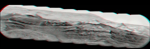 Simulated 3d Pan Simulated 3d Pan
|
|
|
|
|
Apr 6 2017, 08:31 PM
Post
#1198
|
||
|
Senior Member Group: Members Posts: 2425 Joined: 30-January 13 From: Penang, Malaysia. Member No.: 6853 |
Curiosity Mission Update Sols 1659-1660: Time to Hit the Road Again
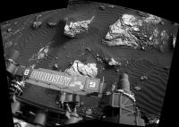
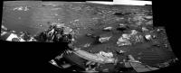
QUOTE Curiosity has been carrying out a great investigation at Ogunquit Beach, but were still working out some issues related to the drill feed, so the decision was made to drive away in todays plan. Were driving away with a cache full of sand, so we can still deliver to CheMin and SAM in a future plan. I was the Geology Science Theme Lead today, and our plan was focused on picking up a few last observations at Ogunquit Beach before driving away. The plan starts with APXS on undisturbed sand at the target Pamola, with corresponding MAHLI documentation images. This observation will be helpful to compare to APXS results from the disturbed sand in the wheel scuff. Later in the afternoon, theres another arm backbone to run some drill diagnostics. Then well acquire several high-priority Mastcam change detection observations, to monitor the movement of sand in a few places, one of which corresponds to a previous Navcam dust devil survey. Well also take two stereo mosaics to evaluate ripple wavelength and height. Before we fully drive away, well position the back of the rover over Ogunquit Beach so DAN can take a measurement. Then Curiosity will continue driving to the south. After the drive well take post-drive imaging for targeting, and prepare for the possibility of contact science in the weekend plan. The second sol includes an autonomously selected ChemCam target, and a ChemCam calibration activity. Well also take several Mastcam and Navcam images to search for dust devils and monitor the amount of dust in the atmosphere. Even though were leaving the dune behind, theres some interesting outcrop up ahead so Im excited to see what the more resistant outcrop might hold!
|
|
|
|
|
|
|
Apr 7 2017, 02:38 AM
Post
#1199
|
|
|
Senior Member Group: Members Posts: 2425 Joined: 30-January 13 From: Penang, Malaysia. Member No.: 6853 |
|
|
|
|
|
Apr 7 2017, 11:09 AM
Post
#1200
|
||
|
Senior Member Group: Members Posts: 2425 Joined: 30-January 13 From: Penang, Malaysia. Member No.: 6853 |
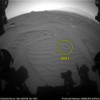
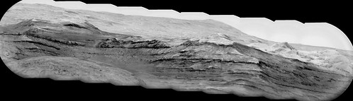
1659 : L-NavCam partial pan that may help to refine the location until the rest come down
|
|
|
|
|
|
|

|
Lo-Fi Version | Time is now: 20th April 2024 - 01:31 AM |
|
RULES AND GUIDELINES Please read the Forum Rules and Guidelines before posting. IMAGE COPYRIGHT |
OPINIONS AND MODERATION Opinions expressed on UnmannedSpaceflight.com are those of the individual posters and do not necessarily reflect the opinions of UnmannedSpaceflight.com or The Planetary Society. The all-volunteer UnmannedSpaceflight.com moderation team is wholly independent of The Planetary Society. The Planetary Society has no influence over decisions made by the UnmannedSpaceflight.com moderators. |
SUPPORT THE FORUM Unmannedspaceflight.com is funded by the Planetary Society. Please consider supporting our work and many other projects by donating to the Society or becoming a member. |
|