Winter campaign at Cook Haven, Sol 3512 - 3599 (December 13, 2013 - March 10, 2014) |

  |
Winter campaign at Cook Haven, Sol 3512 - 3599 (December 13, 2013 - March 10, 2014) |
 Feb 15 2014, 12:33 AM Feb 15 2014, 12:33 AM
Post
#151
|
|
|
Senior Member  Group: Members Posts: 3516 Joined: 4-November 05 From: North Wales Member No.: 542 |
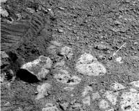
The location may be solved but we still have two hypotheses for the formation of the bright componenet. It's either formed recently near the surface or it is a serendipitous exposure of something ancient. I'm going with number one. There is some water vapour in the air and it must go through cycles of condensation and sublimation. There will be an active layer at some depth where crystals form, like desert roses in Arabia. Maybe that layer is just a couple of centimetres down and we're seeing the products here.
http://i1.trekearth.com/photos/108334/_dsc4210_800.jpg |
 |
 
|
|
Feb 15 2014, 12:51 AM
Post
#152
|
|
|
Solar System Cartographer Group: Members Posts: 10150 Joined: 5-April 05 From: Canada Member No.: 227 |
On the other hand - that suggests the products should be found almost everywhere. An excavated stratum of unusual material could be much more limited in extent. Maybe mapping occurrences of rocks like this around the hilltop will help resolve the question.
Phil -------------------- ... because the Solar System ain't gonna map itself.
Also to be found posting similar content on https://mastodon.social/@PhilStooke NOTE: everything created by me which I post on UMSF is considered to be in the public domain (NOT CC, public domain) |
|
|
|
|
Feb 15 2014, 02:51 AM
Post
#153
|
|
|
Senior Member Group: Members Posts: 1043 Joined: 17-February 09 Member No.: 4605 |
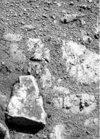
I think I would punt for number two ngunn. Given the miniscule absolute humidity and temperatures it is extremely difficult to see how manganese iron oxide crystals could form, recently, near the surface and internal to Stuart Island, which in itself is potentially an eroded out clast. The Manganese iron oxide crystals alone would seem to point towards a hydrothermal deposition. High magnesium and sulphur content implies a magnesium sulphate. No idea of the hydration state but there would be a high probability that this also formed by ground water mobilisation. We have seen enough kieserite since landing in Eagle crater to imply that water deposition from the atmosphere is effectively non-existent.
|
|
|
|
|
Feb 15 2014, 06:35 AM
Post
#154
|
||
 Senior Member Group: Members Posts: 4246 Joined: 17-January 05 Member No.: 152 |
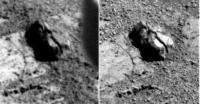
As atomoid reminds us, Oppy's lost bits of hardware before. But I don't think this is a nut, as much as it might look like one:
Probably just a fragment of rock from the PI-forming incident. Edit: this frame from the current location just missed capturing the "nut" at higher resolution: http://qt.exploratorium.edu/mars/opportuni...5M1.JPG?sol3571 |
|
|
|
|
|
|
Feb 16 2014, 08:11 PM
Post
#155
|
|
|
Solar System Cartographer Group: Members Posts: 10150 Joined: 5-April 05 From: Canada Member No.: 227 |
The sol 3578 images:
http://www.midnightplanets.com/web/MERB/sol/03578.html seem to show the right front wheel driving right over Pinnacle Island - an attempt to crush it, probably. Phil -------------------- ... because the Solar System ain't gonna map itself.
Also to be found posting similar content on https://mastodon.social/@PhilStooke NOTE: everything created by me which I post on UMSF is considered to be in the public domain (NOT CC, public domain) |
|
|
|
|
Feb 16 2014, 08:40 PM
Post
#156
|
|
 Senior Member Group: Moderator Posts: 3431 Joined: 11-August 04 From: USA Member No.: 98 |
Hmm... I've been wishing they'd do that, but I think PI is still safely at the bottom of this image, uncrushed, unless I'm missing something. Probably just repositioning, but I do hope they run over it again, and maybe crush some other rocks for good measure!
|
|
|
|
|
Feb 16 2014, 08:52 PM
Post
#157
|
|
|
Solar System Cartographer Group: Members Posts: 10150 Joined: 5-April 05 From: Canada Member No.: 227 |
Oh, right... there are later images, but it's another rock the wheel has probably run over.
Phil -------------------- ... because the Solar System ain't gonna map itself.
Also to be found posting similar content on https://mastodon.social/@PhilStooke NOTE: everything created by me which I post on UMSF is considered to be in the public domain (NOT CC, public domain) |
|
|
|
|
Feb 16 2014, 09:21 PM
Post
#158
|
|
 Senior Member Group: Members Posts: 2228 Joined: 1-December 04 From: Marble Falls, Texas, USA Member No.: 116 |
omg, all of this talk about the violent treatment of rocks has left me feeling faint.

-------------------- ...Tom
I'm not a Space Fan, I'm a Space Exploration Enthusiast. |
|
|
|
|
Feb 16 2014, 10:44 PM
Post
#159
|
|
|
Member Group: Members Posts: 507 Joined: 10-September 08 Member No.: 4338 |
http://marsrovers.nasa.gov/gallery/all/1/p...FCP2535R7M1.JPG
The dark rock on the right looks different from this earlier image. [EDIT: Sorry for being unclear. Comparing the above image to the image linked in mhoward's post: http://www.midnightplanets.com/web/MERB/im...4P1205R0M1.html there is a very dark rock that appears to have been crushed. That it is the same is evident from the bedrock underneath although the perspective is quite different. (I think the rock is in one piece in the prior image although it looks cracked and is partially in shadow.)] |
|
|
|
|
Feb 17 2014, 03:40 PM
Post
#160
|
||
|
Senior Member Group: Members Posts: 4246 Joined: 17-January 05 Member No.: 152 |
Which two images are you comparing, marsophile?
QUOTE (fredk @ Feb 15 2014, 07:35 AM)  Probably just a fragment of rock As expected, a fragment it is:
|
|
|
|
|
|
|
Feb 17 2014, 06:59 PM
Post
#161
|
||
|
Member Group: Members Posts: 507 Joined: 10-September 08 Member No.: 4338 |
QUOTE (marsophile @ Feb 16 2014, 02:44 PM) The dark rock on the right looks different...
On second thoughts, it might be an illusion caused by the change in perspective. The rock looks pretty beaten up even in this earlier image. |
|
|
|
|
|
|
Feb 17 2014, 07:04 PM
Post
#162
|
||
|
Senior Member Group: Members Posts: 2819 Joined: 22-April 05 From: Ridderkerk, Netherlands Member No.: 353 |
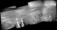
The Navcam images from Sol 3571 and Sol 3573 stitched together.
Jan van Driel
|
|
|
|
|
|
|
Feb 18 2014, 09:49 PM
Post
#163
|
|
|
Member Group: Members Posts: 866 Joined: 15-March 05 From: Santa Cruz, CA Member No.: 196 |
QUOTE (serpens @ Feb 14 2014, 06:51 PM) I think I would punt for number two ngunn. Given the miniscule absolute humidity and temperatures it is extremely difficult to see how manganese iron oxide crystals could form, recently, near the surface and internal to Stuart Island, which in itself is potentially an eroded out clast. The Manganese iron oxide crystals alone would seem to point towards a hydrothermal deposition. High magnesium and sulphur content implies a magnesium sulphate. No idea of the hydration state but there would be a high probability that this also formed by ground water mobilisation. We have seen enough kieserite since landing in Eagle crater to imply that water deposition from the atmosphere is effectively non-existent. As an alternative to truly 'ancient' deposits (hundreds of thousands of years, rather than billions), might it be plausible for the source of humidity to be associated with a recent Milankovitch epoch, one in which an overlying snowpack drift accumulates against and outcrop and becomes buried by blowing sand to linger below the surface long enough to eventually interact and form deposits like this? and the non-ubiquity of such deposits be explained by the initial uneven formation and weathering in the intervening eons? |
|
|
|
|
Feb 18 2014, 10:30 PM
Post
#164
|
|
|
Senior Member Group: Members Posts: 3516 Joined: 4-November 05 From: North Wales Member No.: 542 |
I appreciate both replies on this topic. Regarding the unusual elemental composition, undoubtedly that has to have arrived with the rock itself. That's no surprise. We know the sediments here contain fragments of many different types of source rock, no doubt from diverse locations traversed by the episodic flooding events. So far I'm with serpens. That said, I also think it's likely that atypical rocks that find themselves just centimetres below a freshly exposed surface as erosion proceeds will undergo at that stage more rapid changes than they have done during long term burial. In particular they will be subject to temperature variations and perhaps humidity cycles too: daily, yearly and astronomical (Croll-Milankovich). Also pH changes. So recent recrystallisation processes have to be considered a possibility.
|
|
|
|
|
Feb 19 2014, 03:38 AM
Post
#165
|
|
|
Senior Member Group: Members Posts: 1043 Joined: 17-February 09 Member No.: 4605 |
Temperature is a limiting factor for formation of manganese iron oxide so a bit more than snow or humidity would seem to be necessary. Other than hydrothermal, I guess the most likely mechanism would be formation of bixbyite in the high temperature, steam rich impact cloud when Endeavour formed. Both scenarios would explain the positioning in rim breccia.
|
|
|
|
|

|
Lo-Fi Version | Time is now: 24th April 2024 - 10:10 AM |
|
RULES AND GUIDELINES Please read the Forum Rules and Guidelines before posting. IMAGE COPYRIGHT |
OPINIONS AND MODERATION Opinions expressed on UnmannedSpaceflight.com are those of the individual posters and do not necessarily reflect the opinions of UnmannedSpaceflight.com or The Planetary Society. The all-volunteer UnmannedSpaceflight.com moderation team is wholly independent of The Planetary Society. The Planetary Society has no influence over decisions made by the UnmannedSpaceflight.com moderators. |
SUPPORT THE FORUM Unmannedspaceflight.com is funded by the Planetary Society. Please consider supporting our work and many other projects by donating to the Society or becoming a member. |
|