Martian Cartography |

  |
Martian Cartography |
 Nov 28 2018, 10:36 AM Nov 28 2018, 10:36 AM
Post
#91
|
|
|
Newbie  Group: Members Posts: 2 Joined: 5-June 08 Member No.: 4186 |
|
 |
 
|
|
Nov 28 2018, 03:00 PM
Post
#92
|
|
|
Member Group: Admin Posts: 976 Joined: 29-September 06 From: Pasadena, CA - USA Member No.: 1200 |
QUOTE (Rain @ Nov 28 2018, 02:36 AM)  HiRISE DEMs are available here: https://www.uahirise.org/dtm/ Keep in mind that the corner coordinates can be of by quite a bit. Paolo -------------------- Disclaimer: all opinions, ideas and information included here are my own,and should not be intended to represent opinion or policy of my employer.
|
|
|
|
|
Jan 7 2019, 08:02 PM
Post
#93
|
||
 Member Group: Members Posts: 349 Joined: 20-June 07 From: Slovenia Member No.: 2461 |
I am currently doing some Mars cartography work and just realised that Spirit and Opportunity tracks in Mars2000 Sphere projection published at Analyst's Notebook don't align with Google Earth kml based data and vice versa. Does anyone have any idea which projection is used to display Google Mars data, as it does not seem to use standard GSC/WGS84? Thank you.
Attached thumbnail(s)
|
|
|
|
|
|
|
Jan 9 2019, 04:58 AM
Post
#94
|
|
|
Solar System Cartographer Group: Members Posts: 10150 Joined: 5-April 05 From: Canada Member No.: 227 |
I don't know, but I looked at the traverse map in Analysts Notebook and it matches the background map properly. That map is in a cylindrical projection. It might be that cylindrical projection data have been mapped straight onto the GE globe without correction.
Phil -------------------- ... because the Solar System ain't gonna map itself.
Also to be found posting similar content on https://mastodon.social/@PhilStooke NOTE: everything created by me which I post on UMSF is considered to be in the public domain (NOT CC, public domain) |
|
|
|
|
Jan 9 2019, 06:01 PM
Post
#95
|
|
 Member Group: Members Posts: 796 Joined: 27-February 08 From: Heart of Europe Member No.: 4057 |
QUOTE (Rain @ Nov 28 2018, 11:36 AM) Sorry for late reply, you can download global DEMs from MOLA altimeter here: http://pds-geosciences.wustl.edu/missions/mgs/megdr.html There is also combined MOLA/HRSC DEM here but for now server is down thanks to US budget shutdown. -------------------- |
|
|
|
|
Jan 9 2019, 09:45 PM
Post
#96
|
|
|
Member Group: Members Posts: 796 Joined: 27-February 08 From: Heart of Europe Member No.: 4057 |
New version (1.2) of my Topographic Map of Mars.
It contains all official names up to end of year 2018 but main difference between this version and the previous one is new base map with higher resolution so now map shows almost twice as much details. There are also new mini scale bars directly in the map so estimating size of surface features is now much easier when browsing at full resolution. PDF version (171 MB!) contains on top of that more detailed regional maps of most of the landing sites including some future ones (Jezero crater and Oxia Planum). More detailed description of changes is on my blog (in Czech language but there is a Google translate button on the page). 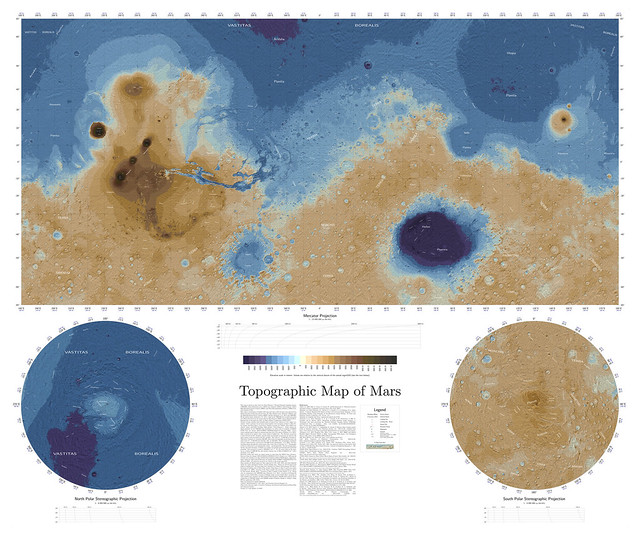
-------------------- |
|
|
|
|
Jan 10 2019, 06:02 PM
Post
#97
|
|
 Senior Member Group: Members Posts: 1083 Joined: 19-February 05 From: Close to Meudon Observatory in France Member No.: 172 |
[quote name='machi' date='Jan 9 2019, 10:45 PM' post='243339']
What a feat ! Congratulations Machi for this outstanding work  Btw, about the deepest point in Hellas, which figure you would recommend for EPO purposes, please : the one derived from MOLA or the one from HRSC ? |
|
|
|
|
Jan 11 2019, 01:38 AM
Post
#98
|
|
|
Member Group: Members Posts: 796 Joined: 27-February 08 From: Heart of Europe Member No.: 4057 |
Thank you!
I would recommend HRSC result. MOLA result is in this case affected by lack of coverage as it clearly missed the lowest point. It's a pity that MOLA suffered fatal malfunction long before MGS' end of mission. We could have better coverage of the Martian surface by the laser altimetry. -------------------- |
|
|
|
|
Jan 11 2019, 09:53 AM
Post
#99
|
|
|
Senior Member Group: Members Posts: 1083 Joined: 19-February 05 From: Close to Meudon Observatory in France Member No.: 172 |
QUOTE (machi @ Jan 11 2019, 02:38 AM) Thank you! I would recommend HRSC result. MOLA result is in this case affected by lack of coverage as it clearly missed the lowest point. It's a pity that MOLA suffered fatal malfunction long before MGS' end of mission. We could have better coverage of the Martian surface by the laser altimetry. Dear Machi, Thank you very much for your kind answer  |
|
|
|
|
Jan 11 2019, 12:14 PM
Post
#100
|
|||
|
Member Group: Members Posts: 349 Joined: 20-June 07 From: Slovenia Member No.: 2461 |
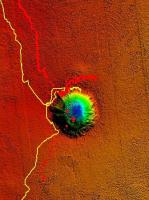
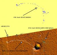
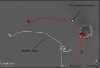
QUOTE (Phil Stooke @ Jan 9 2019, 05:58 AM) I don't know, but I looked at the traverse map in Analysts Notebook and it matches the background map properly. That map is in a cylindrical projection. It might be that cylindrical projection data have been mapped straight onto the GE globe without correction. Phil First of all, thank you Phil very much for your attention, I was really hoping for your answer. Yes, the Analyst's track aligns perfectly with HiRISE imagery as well as with stereo DTM's in Equirectengular Cylindrical Projection using Mars2000 sphere. What does not align are Opportunity tracks (and other Mars data) I originaly got in KML format. The first picture illustrates the point. Even when the track is reprojected from basic WGS84 to Mars2000 sphere datum, KML track still won't align. And vice versa. When I load SHP Analyst's track into GE Mars, it is off by about 200 meters (second picture), but all KML based data aligns nicely. It appears to me the problem lies with the the fact the apparently unknown datum other than WGS84 or Mars2000 Sphere is used by Google Mars, and so the transformation does not work out. For Curiosty rover I only have Fernando Nogal's excellent track in KML and am not sure how well it aligns when reprojected onto EC Mars2000 Sphere map Is it in the right place or is off by the same amount as the other KML Mars data? Thank you in advance, Jack
Attached thumbnail(s)
|
||
|
|
|
||
|
Mar 8 2021, 05:09 AM
Post
#101
|
|
 Member Group: Members Posts: 219 Joined: 14-November 11 From: Washington, DC Member No.: 6237 |
Regarding the map projection & registration, for rover ops, I learned some things when mcaplinger pointed out this MSL document a little while back: https://pds-imaging.jpl.nasa.gov/data/msl/M...CES_PDS_SIS.PDF
For Curiosity, there were some deliberate simplifying assumptions made regarding position plotting on the mission-specific image mosaic. I wonder what the status is for Perseverence... the orthoimages and DEMs at the USGS site (e.g. here) are much larger and more comprehensive from what I can tell, but they may not be exactly what the operations team is using. |
|
|
|
|
Mar 8 2021, 02:10 PM
Post
#102
|
|
|
Member Group: Members Posts: 248 Joined: 25-February 21 From: Waltham, Massachussetts, U.S.A. Member No.: 8974 |
QUOTE (Greenish @ Mar 8 2021, 12:09 AM) Regarding the map projection & registration, for rover ops, I learned some things when mcaplinger pointed out this MSL document a little while back: https://pds-imaging.jpl.nasa.gov/data/msl/M...CES_PDS_SIS.PDF For Curiosity, there were some deliberate simplifying assumptions made regarding position plotting on the mission-specific image mosaic. I wonder what the status is for Perseverence... the orthoimages and DEMs at the USGS site (e.g. here) are much larger and more comprehensive from what I can tell, but they may not be exactly what the operations team is using. Thanks, that is a very helpful document. I learned that the rover positions are with respect to the center between the center wheels, that RMC means Rover Motion Counter, that the onboard positioning can get refined, and how the stacked system of reference frames is defined. Given this, it seems to me that the coordinates provided in the geojson data are directly from the PDS PLACES (or successor) database. Unfortunately, I could not find direct access to the PDS PLACES database for the Mars2020 (M20?) mission, only previous missions, for a more robustly defined source. For example, it is unclear if the geojson provided latitudes are planetocentric or planetodetic as both are described. But choosing the wrong interpretation for projecting back into the equirectangular projection used for the base map would lead to an obvious mismatch I think. I am using that USGS mosaic and here is the geotiff CRS: PROJCRS["Equirectangular Mars 2000 Sphere IAU",BASEGEOGCRS["D_Mars_2000_Sphere",DATUM["Mars_2000_(Sphere)",ELLIPSOID["Mars_2000_Sphere_IAU",3396190,0,LENGTHUNIT["metre",1]],ID["ESRI",106971]],PRIMEM["Reference_Meridian",0,ANGLEUNIT["degree",0.0174532925199433,ID["EPSG",9122]]]],CONVERSION["Equidistant Cylindrical",METHOD["Equidistant Cylindrical",ID["EPSG",1028]],PARAMETER["Latitude of 1st standard parallel",0,ANGLEUNIT["degree",0.0174532925199433],ID["EPSG",8823]],PARAMETER["Longitude of natural origin",0,ANGLEUNIT["degree",0.0174532925199433],ID["EPSG",8802]],PARAMETER["False easting",0,LENGTHUNIT["metre",1],ID["EPSG",8806]],PARAMETER["False northing",0,LENGTHUNIT["metre",1],ID["EPSG",8807]]],CS[Cartesian,2],AXIS["easting",east,ORDER[1],LENGTHUNIT["metre",1,ID["EPSG",9001]]],AXIS["northing",north,ORDER[2],LENGTHUNIT["metre",1,ID["EPSG",9001]]]] - Projected I think it is exactly the projection described in the PDS pdf, including the sphere radius of 3396190m. The Where is the rover ? online map uses leaflet and proj4leaflet plugin which indicates that it uses a custom map projection, likely the equirectangular projection, for the tiled base map. The traverse data on the other hand had a crs field indicating potentially use of a terrestrial crs. I am relying on QGIS/GDAL to convert between CRSs which should be better than trying to do it myself although the conversion is straightforward for this projection. On a side note, I saw in the MSL PDS archives that there are site specific mesh reconstructions of local topography, presumably based on stereo imagery. It would be cool if Mars2020 could make those available. They are probably generated currently. I also saw in the configuration data for the online map that there is an option for "site experiences", and that THREE.js is being loaded, a popular web 3d rendering library, presumably in anticipation of such experiences once they are ready for consumption. Something to look forward to. -------------------- --
Andreas Plesch, andreasplesch at gmail dot com |
|
|
|
|
Mar 9 2021, 07:16 AM
Post
#103
|
|
|
Member Group: Members Posts: 219 Joined: 14-November 11 From: Washington, DC Member No.: 6237 |
Great, I'm glad you were able to make some use of it. I'm a GIS neophyte so appreciate you posting the details.
In terms of other potential resources - this SPICE topocentric kernel was made pre-landing, but other than exact coords of actual landing has useful detail: https://naif.jpl.nasa.gov/pub/naif/MARS2020...z_iau2000_v4.tf (it in turn leads to many rabbit holes, but I think the upshot is that "IAU" + "east-positive longitude" seems to indicate planet'ocentric). The above kernel provides the local definition that connects to the rover kernel, which fully defines all the other transformations. Note that the one in the main folder doesn't seem to be quite as complete as this one, which has more instruments: https://naif.jpl.nasa.gov/pub/naif/MARS2020...ee/m2020_v03.tf So far as I know (which isn't that far) PLACES is internal to JPL. But the data does get published with the periodic PDS releases. I think the .geojson is a great asset that gets most of what we'd want from there in terms of near-real-time location data. |
|
|
|
|
Mar 10 2021, 01:27 AM
Post
#104
|
|
|
Member Group: Members Posts: 248 Joined: 25-February 21 From: Waltham, Massachussetts, U.S.A. Member No.: 8974 |
Wow, another document covering similar topics.
Some notes: https://naif.jpl.nasa.gov/pub/naif/MARS2020...z_iau2000_v4.tf "The landing site Gaussian longitude and latitude upon which the definition is built are: Lon = 77.429800 degrees East Lat = 18.670633 degrees North " This is far from the actual landing site. https://naif.jpl.nasa.gov/pub/naif/MARS2020...ck/pck00010.tpc "Mars Old values: Values are from the 2006 IAU report. body499_radii = ( 3397. 3397. 3375. ) Current values: The 2009 IAU report gives separate values for the north and south polar radii: north: 3373.19 south: 3379.21 The report provides the average of these values as well, which we use as the polar radius for the triaxial model. BODY499_RADII = ( 3396.19 3396.19 3376.20 )" It appears earlier USGS products used this (averaged) ellipsoid but I think now use a spheroid with 3396.19km radius. https://naif.jpl.nasa.gov/pub/naif/MARS2020...ee/m2020_v03.tf "Local Level Frame ------------------------------------------------- M2020 local level frame, M2020_LOCAL_LEVEL, is defined as follows: - +Z axis is along the downward normal at the landing site ("nadir"); - +X axis is along the local north direction ("north"); - +Y axis completes the right hand frame ("east"); - the origin of this frame is located between the rover's middle wheels and moves with the rover. Since this frame is essentially the M2020_TOPO frame flipped by 180 degrees about +X ("north") to point +Z down, this frame is defined as a fixed offset frame with respect to the M2020_TOPO frame." This is consistent with the PLACES document. So these documents seem to be developed together, and do not compete with each other (luckily). There are cool ascii drawings of rover reference frames and mentioning of sclk which shows up as field in the geojson. There are cool ascii drawings of camera reference frames. The MASTCAM frames includes toe in angles of -1.25 deg. and +1.25 deg. for right and left. There are cool ascii drawings of arm axes frames. Everything is referenced by id with value mappings somewhere else. SCLK means SPICE spacecraft clock (SCLK) kernel. It turns out that the PLACES document pdf for MSL lives along with the database archive, last updated in December: https://pds-imaging.jpl.nasa.gov/data/msl/MSLPLC_1XXX/ But there is no PDS archive for Mars2020 yet, it appears. There is a review. But it mentions that PLACES is not included to be picked up later. -------------------- --
Andreas Plesch, andreasplesch at gmail dot com |
|
|
|
|
Mar 10 2021, 03:18 AM
Post
#105
|
|
|
Member Group: Members Posts: 219 Joined: 14-November 11 From: Washington, DC Member No.: 6237 |
QUOTE (Andreas Plesch @ Mar 9 2021, 08:27 PM) This is far from the actual landing site. Sorry if I was unclear. The file was made as a placeholder until actual landing. The M2020 team will be using an updated version by now, but everything except the coords will be identical. (We know those from other sources. Posting operational SPICE kernels on public-facing side is probably not a priority.) |
|
|
|
|

|
Lo-Fi Version | Time is now: 23rd April 2024 - 09:42 PM |
|
RULES AND GUIDELINES Please read the Forum Rules and Guidelines before posting. IMAGE COPYRIGHT |
OPINIONS AND MODERATION Opinions expressed on UnmannedSpaceflight.com are those of the individual posters and do not necessarily reflect the opinions of UnmannedSpaceflight.com or The Planetary Society. The all-volunteer UnmannedSpaceflight.com moderation team is wholly independent of The Planetary Society. The Planetary Society has no influence over decisions made by the UnmannedSpaceflight.com moderators. |
SUPPORT THE FORUM Unmannedspaceflight.com is funded by the Planetary Society. Please consider supporting our work and many other projects by donating to the Society or becoming a member. |
|